Navagio beach Zakynthos.jpg

Ionian Islands, GR

Navagio

A cove no road reaches, known to the world only as one overhead photograph — a rusting freighter on white pebbles that few have ever stood on.

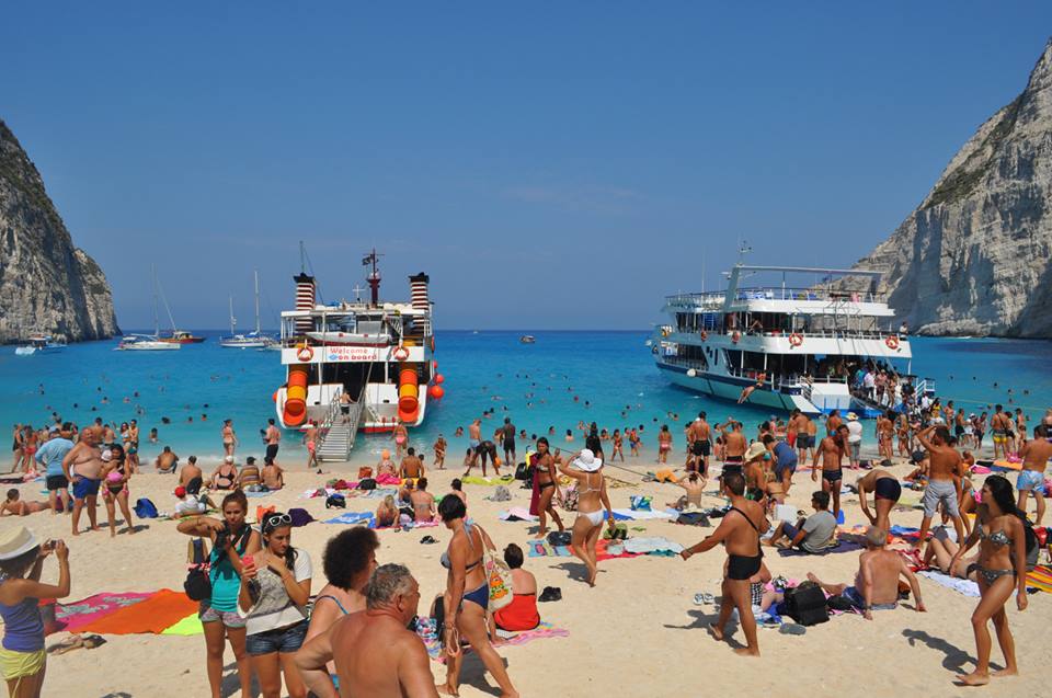
Navagio beach Zakynthos.jpg · <a href="//commons.wikimedia.org/wiki/User:Kallerna" title="User:Kallerna">kallerna</a> · CC BY-SA 4.0
Length
300 m
Nearest airport
ZTH · 26 km
Tier
Featured
I’m here for
Story

Navagio is a cove on the northwest coast of Zakynthos that no road reaches. Limestone cliffs roughly 200 meters high close around three sides of a strip of white pebbles, and the only way in has always been by water. Before 1980 the locals called it Agios Georgios. The name in use today, Navagio, is simply the Greek word for shipwreck.

The wreck that renamed the beach is the MV Panagiotis, and its biography is older than its legend. It was built in 1937 at Bowling on the River Clyde in Scotland as the MV Saint Bedan, a 47.8-meter coastal freighter of 452 gross tons. Under Greek ownership, it ran aground here in early October 1980. The story that travels with it holds the ship was running contraband cigarettes from Turkey and beached in the cove to escape a navy chase in a storm; court records and seized cargo later cited thousands of cigarette cartons aboard. A competing account, attributed to captain Charalambos Kompothekras-Kotsoros, says it carried legitimate freight between Argostoli and Albania when weather drove it ashore, and that twenty-nine islanders were later convicted of stripping the hull. Both versions survive. The rusted ship settled into the pebbles where it remains.

What made Navagio singular is not the wreck alone but the angle. Photographed from the cliff edge directly above, the cove resolves into one composition: the orange-brown freighter dead center, the pebble beach bone-white, the water grading from pale aqua at the shoreline to deep Ionian blue, and the rock walls framing all of it. It is the same shot every time, and that sameness is the point. Navagio became one of the most reproduced images of Greece in the social-media era, a coordinate the internet learned by heart. The local economy reorganized around delivering people to that one frame, by boat to the sand and by car to the platform on the clifftop.

Access is the honest complication. Small boats leave Porto Vromi to the south for a crossing of roughly half an hour; larger excursion boats run from Zakynthos Town and the island's northern ports. The cove has no facilities of any kind: no taverna, no shade, no fresh water, no road out. For decades visitors landed, swam in the cold clear water, photographed the wreck up close, and left on the same boat. The clifftop viewpoint, reached by car and a short walk, gave the postcard angle to anyone who never set foot on the sand.

That arrangement no longer holds. After a cliff failure in 2018 and renewed rockfall following a 2022 earthquake, geologists judged the slopes unstable, and Greek authorities closed the beach to landings and swimming. As of summer 2026 the cove itself is off-limits, viewing is restricted to a fenced observation point above, and boats are barred from approaching the shoreline. The image that conquered the internet is now, for most people, only an image again.
The spike

A cove no road reaches, known to the world only as one overhead photograph — a rusting freighter on white pebbles that few have ever stood on.

the only sanctioned anglenorth platform · ~200 m upboat landing & swimmingprohibited, 2018 →200 mcliff
Why every photograph of Navagio is the same photograph: one cliff-edge platform, one frame, the wreck dead-centre — and, since 2018, no way down.

Navagio is a place the world knows almost entirely as a single overhead photograph. Strip away the picture and what remains is a 200-meter-deep notch in the limestone of Zakynthos's northwest coast, a strip of white pebbles no road reaches, and a rusted freighter that has sat in the same spot since October 1980. None of that is what made it famous. What made it famous was one frame, shot from one place, repeated until it became a coordinate the internet learned by heart.

The anatomy of the canonical image. Walk the cliff above the cove and there is exactly one angle that produces the picture everyone already has in their head. From the fenced platform on the north rim, roughly 200 meters straight up, the camera looks down into a horseshoe of pale limestone walls that close the cove on three sides. The MV Panagiotis sits dead center on the pebbles, its orange-brown corrosion the only warm note in the whole composition. Around it the beach reads bone-white, and the water grades in clean bands from pale aqua at the shoreline to deep Ionian blue where it meets the open sea. The rock walls frame the edges. Crucially, it is the *same* shot every time. There is no second great angle, no alternative composition that competes with it. The cove only resolves into its famous self when you stand where everyone stands and point the lens straight down. That enforced sameness is not a weakness of the image; it is the whole mechanism of its fame.

Why this one frame conquered travel media and Instagram. Most beaches photograph a hundred ways and so dilute into a hundred mediocre pictures. Navagio photographs one way and so concentrates into a single overwhelming one. It is graphically legible at thumbnail size: a bright cove, a dark wreck, a hard frame of rock, colors saturated enough to survive any feed. The wreck supplies narrative — a ship, a story, a question — where an empty beach supplies only scenery. And the overhead vantage flatters the human instinct for the godlike view, the sense of looking *down* on a secret place rather than *across* an ordinary one. Travel magazines reproduced it because it sold covers; the social-media era reproduced it because it was the perfect unit of envy, instantly recognizable and endlessly repeatable. The local economy reorganized itself around delivering people to that exact frame — boats to the sand below, cars to the platform above. Navagio stopped being a beach people visited and became an image people collected.

The wreck's real, contested history. The object at the center of all this is older than its legend and less settled than the postcard implies. The MV Panagiotis was not built for Greek waters at all. It was launched in 1937 at Bowling on the River Clyde in Scotland as the MV Saint Bedan, a 47.8-meter coastal freighter of 452 gross tons. Under Greek ownership it ran aground in early October 1980, in a cove then still called Agios Georgios. From there the story forks and never rejoins. The popular account holds the ship was running contraband cigarettes from Turkey and beached deliberately to escape a navy chase in a storm — an account partly corroborated by court records citing thousands of seized cigarette cartons. A competing version, attributed to captain Charalambos Kompothekras-Kotsoros, says the vessel carried legitimate freight between Argostoli and Albania and was simply driven ashore by weather. Both accounts survive intact; neither has erased the other. What is documented is the aftermath: twenty-nine islanders were convicted of stripping the abandoned hull. The beach took its current name, Navagio — the Greek word for shipwreck — from the rusting evidence of whichever story is true.

The access paradox. Here is the uncomfortable engine of the whole thing. The image drew crowds the cove was never built to hold — hundreds of people at a time on a strip of pebbles with no exits, no shade, no fresh water, and no way out except the boat that brought them. Above them, the same soft limestone that frames the famous shot kept eroding. On a September day in 2018, a slab broke off the cliff and fell onto a beach full of swimmers. A Czech tourist suffered a fractured vertebra, six others were injured, and the falling rock threw up a wave that capsized small boats below. The beach reopened in 2019, but a 5.4-magnitude earthquake in September 2022 triggered fresh rockfalls, and after geological assessment Greek authorities closed the cove to landings, swimming, and close approach by boat. The closure has been extended repeatedly and now runs through 31 October 2026. The crowds chasing the photograph helped load the very walls whose failure shut the cove. The picture, in a real and measurable sense, helped make its own subject unreachable.

The melancholy of the thing. The result is a quietly strange fact: the most-photographed beach in Greece is now one almost no one is allowed to stand on. For most visitors Navagio is sold as a beach they can only look at, from a 10-meter platform 200 meters above the sand, the wreck rusting where it has rusted since 1980 and the water grading through its famous bands with no one in it. The closure has enforced, as policy, the exact distance the image always implied — the gap between the photograph and the place. The internet conquered a cove and, in conquering it, was locked out of it. What is left is the view, the wreck, and the honesty of a destination most of its admirers will only ever see as a picture again.

Navagio Beach.jpg
Culture

Where it shows up

History
  • The smuggling legend of the Panagiotis · 1980

    The popular account that the freighter was running contraband cigarettes from Turkey and beached in the cove to escape a navy pursuit in a storm. Long an unverified local legend, it is partly corroborated by court records citing seized cargo, though a competing account of legitimate freight driven ashore by weather also survives.

Other
  • "Smugglers Cove" / one of Greece's most-photographed images

    Navagio circulates online under the nickname Smugglers Cove and stands as one of the most reproduced images of Greece in the social-media era, where the beach is known almost entirely through a single overhead photograph rather than as a place people visit.

  • Overtourism case study

    Navagio is frequently cited in Greek and international coverage as a case of an image-driven destination overwhelmed by the crowds the image attracted, a tension that authorities named explicitly when extending the closure to manage both landslide risk and overtourism.

Navagio, Zante 01.jpg
History

What happened here

  1. 1937founding

    The ship is built in Scotland

    The freighter later known as the MV Panagiotis is launched as the MV Saint Bedan at Bowling on the River Clyde in Scotland, a 47.8-meter coastal vessel of 452 gross tons.

    Wikipedia →
  2. 1980disaster

    The Panagiotis runs aground at Agios Georgios

    In early October 1980 the Panagiotis runs aground in the cove then known as Agios Georgios. The widely told account holds it was smuggling contraband cigarettes from Turkey and beached to evade a navy chase in a storm; a competing account cites legitimate cargo driven ashore by weather.

    Wikipedia →
  3. 1980cultural

    The cove is renamed Navagio

    After the wreck, the cove's older name Agios Georgios falls out of use and it becomes known as Navagio, the Greek word for shipwreck. Twenty-nine islanders are later convicted of plundering the abandoned hull.

    Wikipedia →
  4. 2018disaster

    Cliff collapse injures swimmers

    A slab breaks off the roughly 200-meter cliff and falls onto a crowded beach. A 34-year-old Czech woman is hospitalized with a fractured vertebra and six others are injured; the falling rock raises a wave that capsizes several small boats.

  5. 2018policy

    First closure after the rockfall

    Greek authorities close Navagio to visitors immediately after the collapse while the slopes are assessed.

  6. 2019policy

    Reopening

    The beach reopens to visitors in spring 2019 after the post-collapse closure.

  7. 2022natural

    Earthquake triggers new rockfalls

    A 5.4-magnitude earthquake in the sea between Zakynthos and Kefalonia sets off fresh rockfalls around the cove, and the beach is closed again.

  8. 2023policy

    Indefinite closure on geological advice

    Following assessment by Greece's Earthquake Planning and Protection Organization (OASP), authorities extend the closure of Navagio with no fixed reopening date, citing unstable perimeter slopes.

  9. 2024policy

    Closure renewed; viewing limited to a platform

    The cove remains closed to landing and swimming; access to the clifftop is funneled to a small designated observation point, with fencing and protective works carried out by the Municipality of Zakynthos. Boats are barred from approaching the shoreline.

  10. 2026policy

    Closure extended through October 2026

    Authorities extend the full closure of Navagio through October 31, 2026, citing both ongoing landslide risk and the need to manage overtourism. The cove itself stays off-limits; the view is available only from the clifftop platform.

The honest part
The crowds chasing a picture of an empty cove helped make that cove unsafe to stand in.

The gap between the photograph and the place is now official policy. For years the single overhead shot drew crowds that the cove was never built to hold, hundreds of people at a time on a strip of pebbles with no exits, while the soft limestone above kept eroding. On a September day in 2018, a slab broke off the cliff and fell onto a beach full of swimmers; a Czech tourist suffered a fractured vertebra, six others were hurt, and the falling rock threw up a wave that capsized small boats. The beach reopened in 2019, but a 5.4-magnitude earthquake in September 2022 triggered fresh rockfalls, and after geological assessment Greek authorities closed Navagio to landings, swimming, and close approach by boat. The closure has been extended repeatedly and currently runs through October 31, 2026.

The result is an uncomfortable honesty. Navagio is a destination most of its visitors can no longer reach, sold to them as a beach they can only look at from a 10-meter platform on the clifftop. The crowds chasing a picture of an empty cove helped make that cove unsafe to stand in. What remains is the view, the wreck rusting where it has rusted since 1980, and the distance the closure now enforces between the photograph and the sand.

Navagio "Shipwreck" Beach aerial (44653856390).jpg
Anatomy

The shape of the place

Boat approach from the sea

20%

The open-water approach from Porto Vromi to the south (about a 30-minute crossing) and from the island's northern ports, the route by which every visitor historically arrived.

Excursion boats still run along the coast, but anchoring and close approach to the cove are restricted under the closure.

The swimming cove

40%

The white-pebble strand and the cold, clear, fast-shelving water where visitors swam for decades. No shade, no fresh water, no facilities of any kind.

Swimming is banned under the current closure; boats may not approach within the restricted zone of the shoreline.

The MV Panagiotis

50%

The rusted freighter half-settled into the pebbles at the center of the cove, the single object every photograph is built around. Built 1937 in Scotland, grounded here in 1980, corroding in place ever since.

Best for The defining photograph

Landing is currently prohibited; the wreck can be seen only from the clifftop or from boats kept offshore.

Clifftop observation point

50%

The fenced platform on the cliff edge roughly 200 meters above the cove, reached by car and a short walk from the north of the island. It delivers the overhead angle of the famous image.

Best for The postcard view without a boat

Now the only sanctioned way to see Navagio; access is confined to the designated point after protective works by the Municipality of Zakynthos.

Landmarks

MV Panagiotis (the shipwreck) · 1937

shipwreck

Coastal freighter built in 1937 at Bowling, Scotland as the MV Saint Bedan; 47.8 meters, 452 gross tons. Grounded in the cove in October 1980 and abandoned there. Its presence renamed the beach Navagio and is the subject of essentially every photograph taken of the place.

Wikipedia →

Navagio clifftop observation platform

viewpoint

The fenced viewing point on the cliff edge about 200 meters above the cove, on the island's northwest. It supplies the overhead composition the beach is famous for and, under the current closure, is the only authorized way to see Navagio.

Navagio cliffs

natural

The near-vertical limestone walls, roughly 200 meters high, that enclose the cove on three sides and make it reachable only from the sea. Their erosion is the reason the beach is currently closed.

A day here

From first light to dark

Dawn

At first light the cove is still in shadow under its west-facing cliffs, the water flat and the wreck a dark shape before the sun clears the rock. The first excursion boats have not yet left Porto Vromi or the northern ports, so the photographers at the clifftop platform have the silence to themselves.

Midday

By late morning the sun is overhead, the water lights to the aqua-and-blue gradient of the famous shot, and the platform fills with people working the same frame. In open years this was the crush hour on the sand; now the crowd gathers above, leaning to the fence for the angle the closure preserves only from a distance.

Golden hour

Late afternoon throws warm light onto the upper cliffs and the rust of the hull while the lower cove falls into shade, the contrast that flatters the wreck most. The day boats thin out as crews head back to harbor before dusk.

Night

After dark the cove is empty and unlit, with no facilities, no road, and no one staying. The clifftop above sees occasional headlights and the rare visitor who drives up for the stars over the Ionian, then nothing but the water moving against the pebbles.

Navagio Beach and Shipwreck of the Panagiotis at 'Smugglers Cove' Zakynthos.JPG
Sea & surf

What the water does

JFMAMJJASONDmetres (significant wave height)

Solid = typical monthly wave height; pale = the bigger days (90th pct). Offshore/regional swell from Open-Meteo Marine (ERA5 Ocean reanalysis, 2023–2024); a sheltered cove may sit calmer than this.

Mixed — usually swimmable, with a livelier season
Typical wave height
1.11 m
Biggest swell
Jan · 1.61 m
Calmest
Jun · 0.71 m
Typical period
5.7 s (wind chop)
Before you go

Things to know

Access

The cove is closed to landing and swimming through at least 31 October 2026 after rockfalls; only the clifftop viewing platform is open.

Getting on the sand

When open, the beach is reachable only by boat — tour caiques run from Porto Vromi (~30-min crossing) and the north of Zakynthos.

The viewpoint

The famous overhead photograph is taken from a railed platform high above the cove; parts of the cliff path are unfenced.

Sharks

No incidents on record in the global shark-attack file.

Plan

If you go

Getting there
Nearest airport
Zakynthos International Airport Dionysios Solomos (ZTH) · 26 km
Nearest town
Katastarion · 12 km

There is no road to the cove. Boat tours depart Porto Vromi (south) and the north of Zakynthos; the clifftop viewpoint is a separate drive via Anafonitria village.

When to go
  • Summer boat-tour season · Roughly May to September, peaking in July and August

    The high season for excursion boats running the northwest coast from Porto Vromi and the northern ports. Even with the cove closed to landing, operators continue to bring visitors along the coastline within the permitted limits, and the clifftop viewpoint draws its heaviest crowds in these months.

What to eat & drink
Nothing on the beach

Navagio is an isolated cove with no taverna, kiosk, shade, or fresh water, and the closure now bars landing entirely. Eat and drink before you board or after you return; carry your own water for the clifftop, which is just as exposed.

Plan around the cove, not in it

Grilled fresh fish and Zakynthian olive oil

The standard Ionian taverna meal: whatever was landed that morning, grilled whole and dressed with local oil and lemon, eaten at the harbor where the Navagio boats depart.

Tavernas at Porto Vromi harbor, the southern departure point

Ladotyri Zakynthou (oil cheese)

Zakynthos's PDO sheep's-milk cheese, hard and salty, traditionally matured in olive oil. A regional specialty rather than a tourist invention, found in island shops and on meze plates.

Volimes and village markets in the island's mountainous northwest

Mandolato and local wine

Mandolato is the island's soft nougat of honey, sugar, and almonds, a long-standing Zakynthian sweet; pair it with wine from the Zakynthos plain. Both predate the beach's fame and are sold across the island.

Zakynthos Town and inland villages

Go deeper
Sources & references
  1. Wikipedia: MV Panagiotis · cited 6×
  2. Wikipedia: MV Panagiotis; BBC News · cited 2×
  3. The Pappas Post; The Traveler · cited 2×
  4. BBC News, 13 September 2018; The National Herald
  5. GTP Headlines, 24 September 2018
  6. GreekReporter; Hellenic News
  7. GreekReporter, 8 September 2022
  8. RTE News; Neos Kosmos, March 2023
  9. GTP Headlines, 10 May 2024; To Vima
  10. Beach geology / island surveys
  11. Local operators / island access notes
Colophon · Provenance

Where this page comes from

Geography, facilities
OpenStreetMap (ODbL) for geometry and facility tags within 500 m of the beach centroid. GeoNames for city/airport distances.
Climate & ocean
Open-Meteo ERA5 + Marine archive, 2014–2023 monthly normals.
Photography
Archival, original tone (Tier B — Wikimedia Commons). Each image licensed per its own terms; attribution visible inline.
History & culture
Every factual claim is linked to its source in the prose above. Wikipedia citations inline. Non-wiki sources named where relevant.
Editorial voice
Register: melancholic. Written to pass a local's nod test; corrections welcome.
Written by Erin Rose
Last reviewed 2026-04-19
v0.9in editorial development toward v1.0