The shell-shaped bay on the Portuguese Atlantic. A 900-year-old Cistercian fishery that became the Silver Coast's family beach.
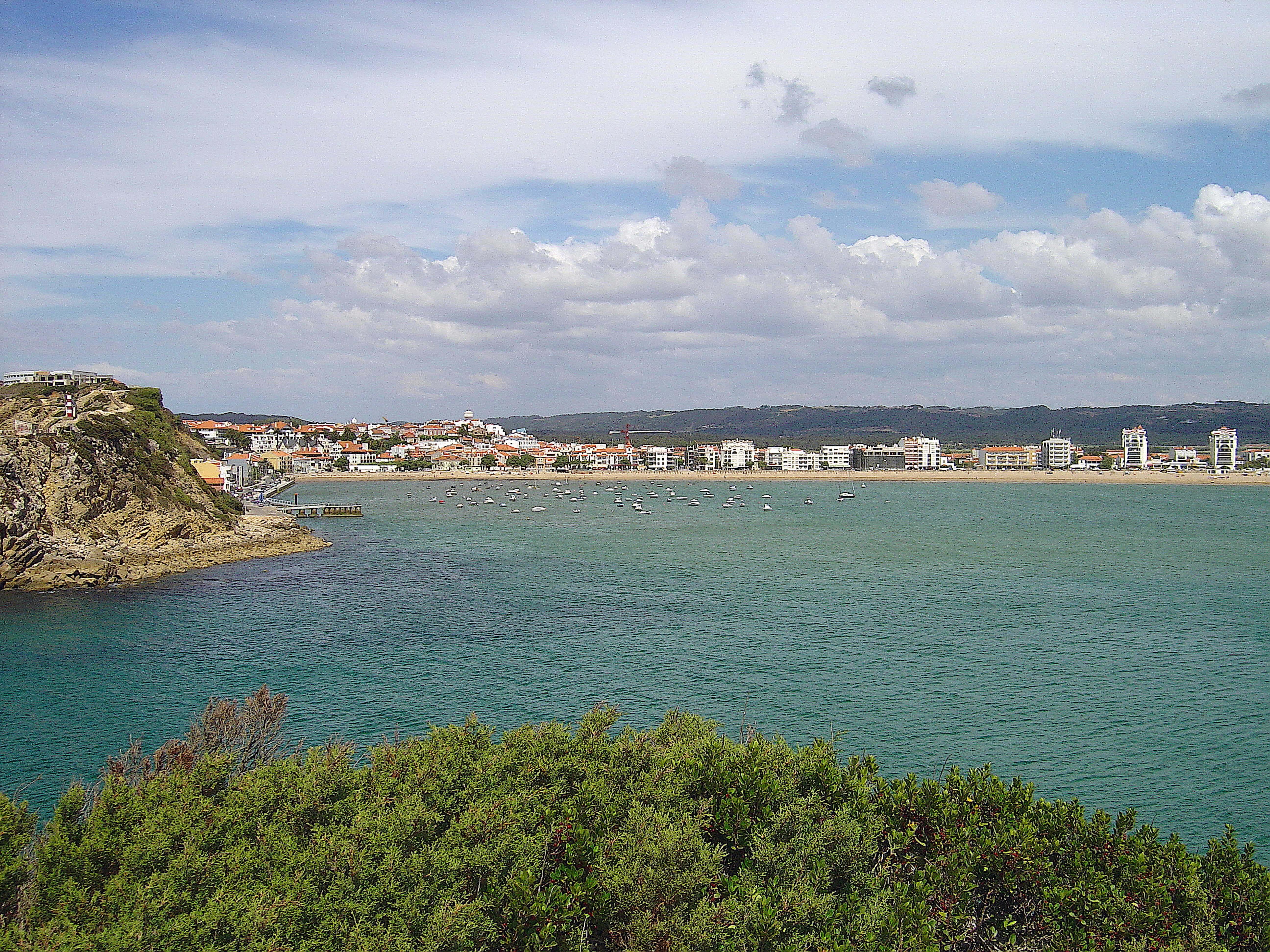
São Martinho do Porto — the shell-shaped bay from the southern headland · Vitor Oliveira (Torres Vedras) · CC BY-SA 2.0
· Story
São Martinho do Porto is a Portuguese coastal town of roughly 3,000 permanent residents, ten kilometers south of Nazaré, whose beach is the almost-perfectly-closed circle of a natural harbor. The bay is two kilometers across. Its only opening to the Atlantic — the Boca da Baía — is a narrow 200-meter channel between two rocky headlands. Everything inside is calm. Everything outside is the same Portuguese Atlantic that produces the world's biggest surfable waves at Nazaré, ten kilometers north. The contrast is geographic: the shell-shaped opening is a tectonic accident that trapped a chamber of Atlantic water and made it swimmable in a country whose coast, generally, is not.
The bay has been used as a harbor since at least the Roman period. The town's name — *Porto de São Martinho* — retains the older meaning: the port of the saint, named for Martin of Tours, who is also the patron saint of Alcobaça, the great Cistercian monastery twenty kilometers inland whose lands reached the sea here. The 12th-century Cistercians of Alcobaça collected salt and fish from this bay for six hundred years. The monastery's coastal fishing rights — the *coutos de Alcobaça* — are still a feature of local municipal boundaries.
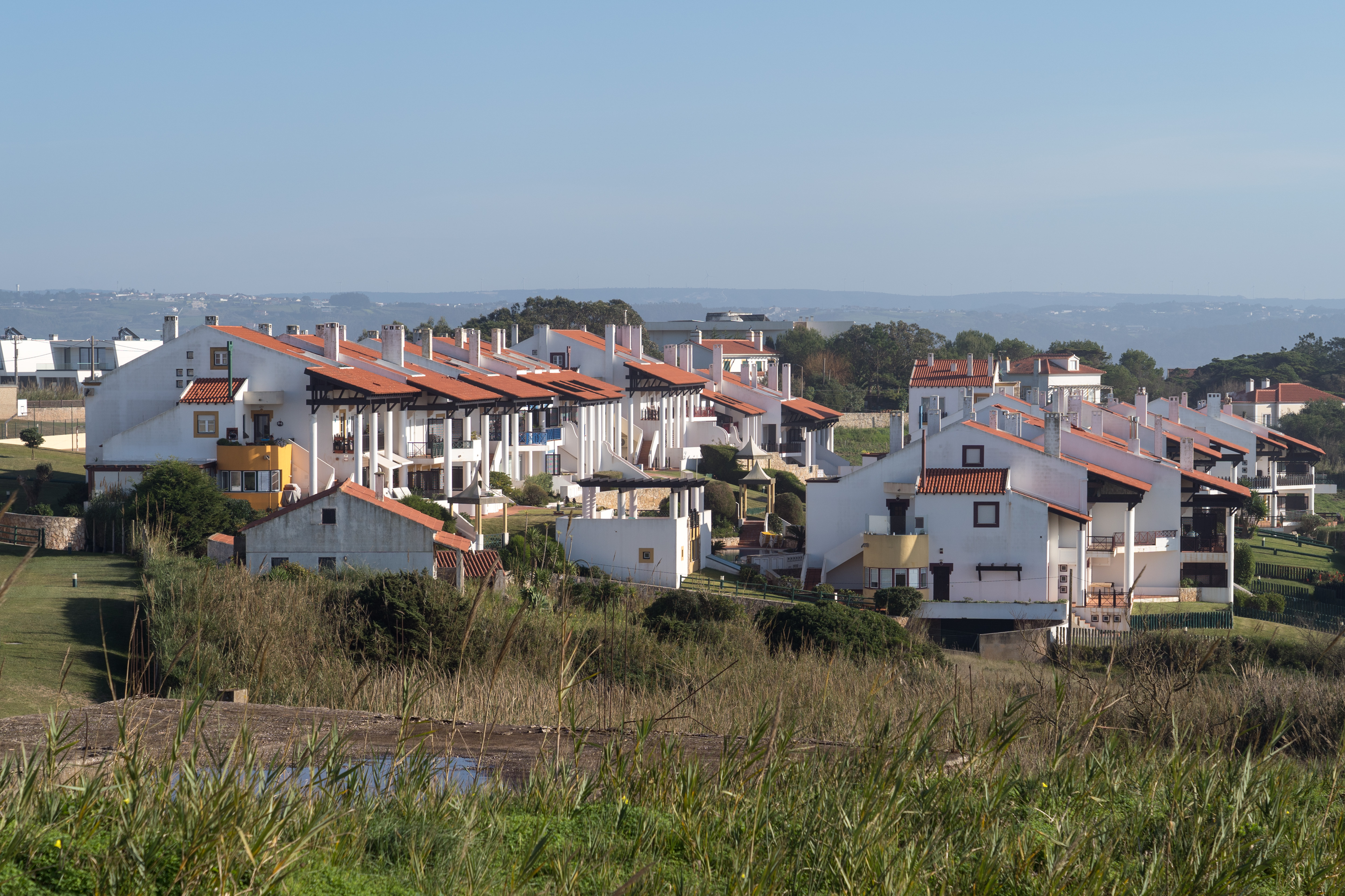
Tourism at São Martinho is older than tourism at Nazaré. The railway from Caldas da Rainha reached the bay in 1887, two generations before Nazaré's big-wave era made the coast famous internationally. Portuguese middle-class families summered here through the late 19th and early 20th centuries. The early-20th-century houses along Avenida Marginal — tile-fronted, two-story, pitched-roof — are the domestic architecture of a Portuguese seaside resort of that period, and many still stand.
The bay today is the defining family beach of the Silver Coast. The water is warm by Atlantic standards (18–21 °C June–September), calm because of the geography, and safe for children in a way the rest of this coastline is not. The visitor who stays in Nazaré to watch big-wave surfing, then drives south to São Martinho for an afternoon with swimmable water, is doing exactly what a Portuguese family from Lisbon or Leiria has done for a century.
· The Shell-Shaped Bay
Why this specific stretch of the Portuguese Atlantic is swimmable
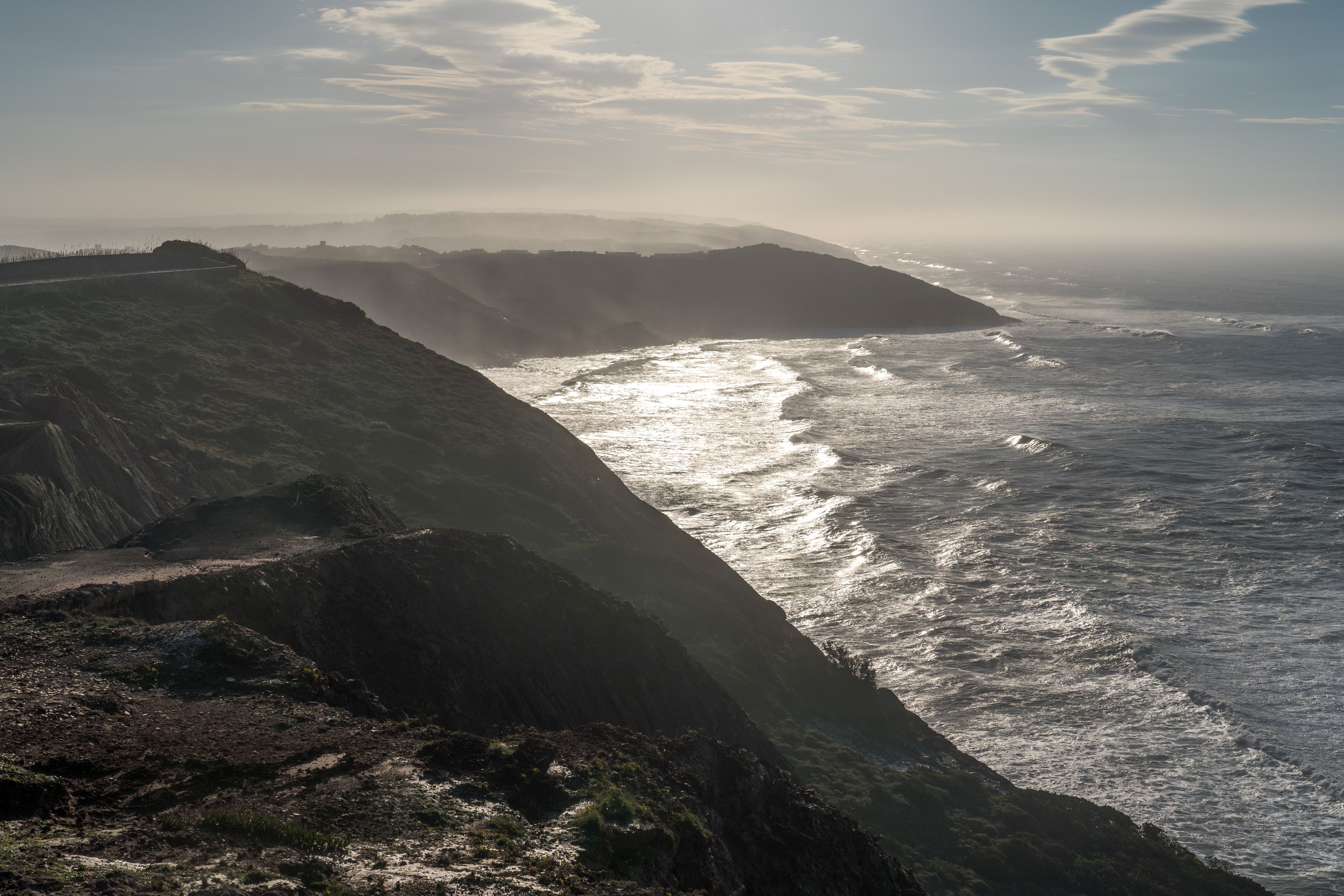
The Nazaré Canyon produces the largest surfable waves on Earth, ten kilometers north of here. São Martinho's bay is the exact opposite feature — a closed chamber that traps calm water on the same coastline. The geometry is not accidental.
The geometry
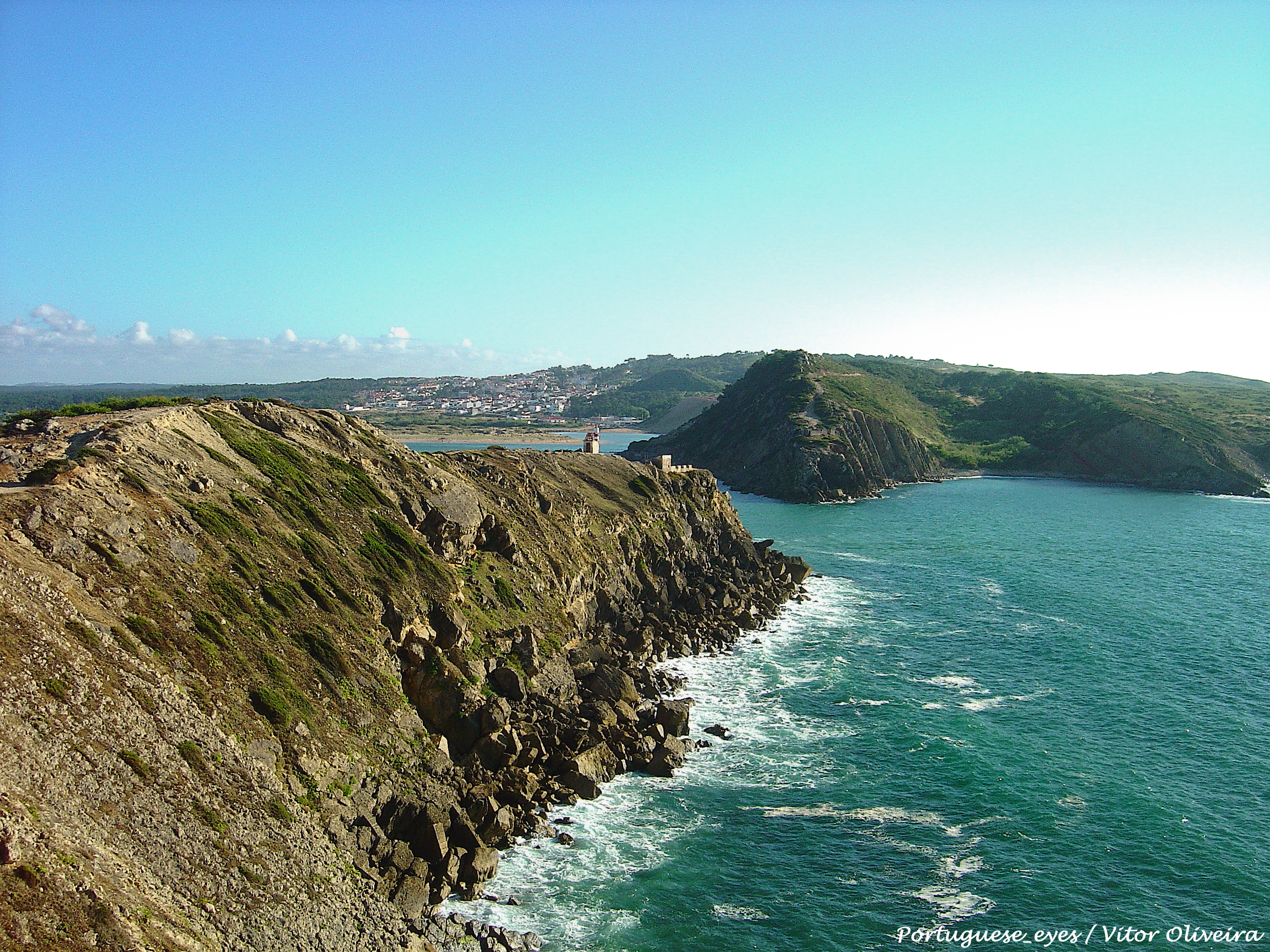
The bay of São Martinho is almost a perfect circle — roughly 2 kilometers in diameter, enclosed on three sides by Jurassic limestone cliffs that curve inward to leave only a narrow opening to the Atlantic. That opening — the Boca da Baía — is approximately 200 meters wide at its narrowest, running roughly north-south between the two rocky headlands.
The shape is the result of differential erosion of the surrounding sedimentary rock over millions of years. The cliffs enclosing the bay are Upper Jurassic limestone — around 150 million years old — laid down when this stretch of Iberia was shallow coastal sea. Harder beds of the limestone (the two headlands) resisted erosion; softer beds (where the bay now sits) eroded faster. The Atlantic, working on the softer material for millennia, carved the circular cavity. The Boca is the narrow breach where the softer material extended to the coastline.
The functional consequence: Atlantic swell that arrives at the Boca is largely blocked from entering the bay. What does get through refracts around the headlands and loses most of its energy. The inside of the bay, on a day when the outside coast is being hit by 3-meter surf, is a calm lagoon. The water temperature runs 2–3 °C warmer than the open Atlantic because the bay is shallow and slow to flush. Currents are mild. This is the only stretch of the Portuguese west coast where a non-swimmer can stand waist-deep in the Atlantic without anxiety.
Looking out from the inside of the bay toward the Boca — the narrow 200-meter opening that keeps Atlantic swell out. December 2025.· Alexkom000
Dinosaurs on the cliffs
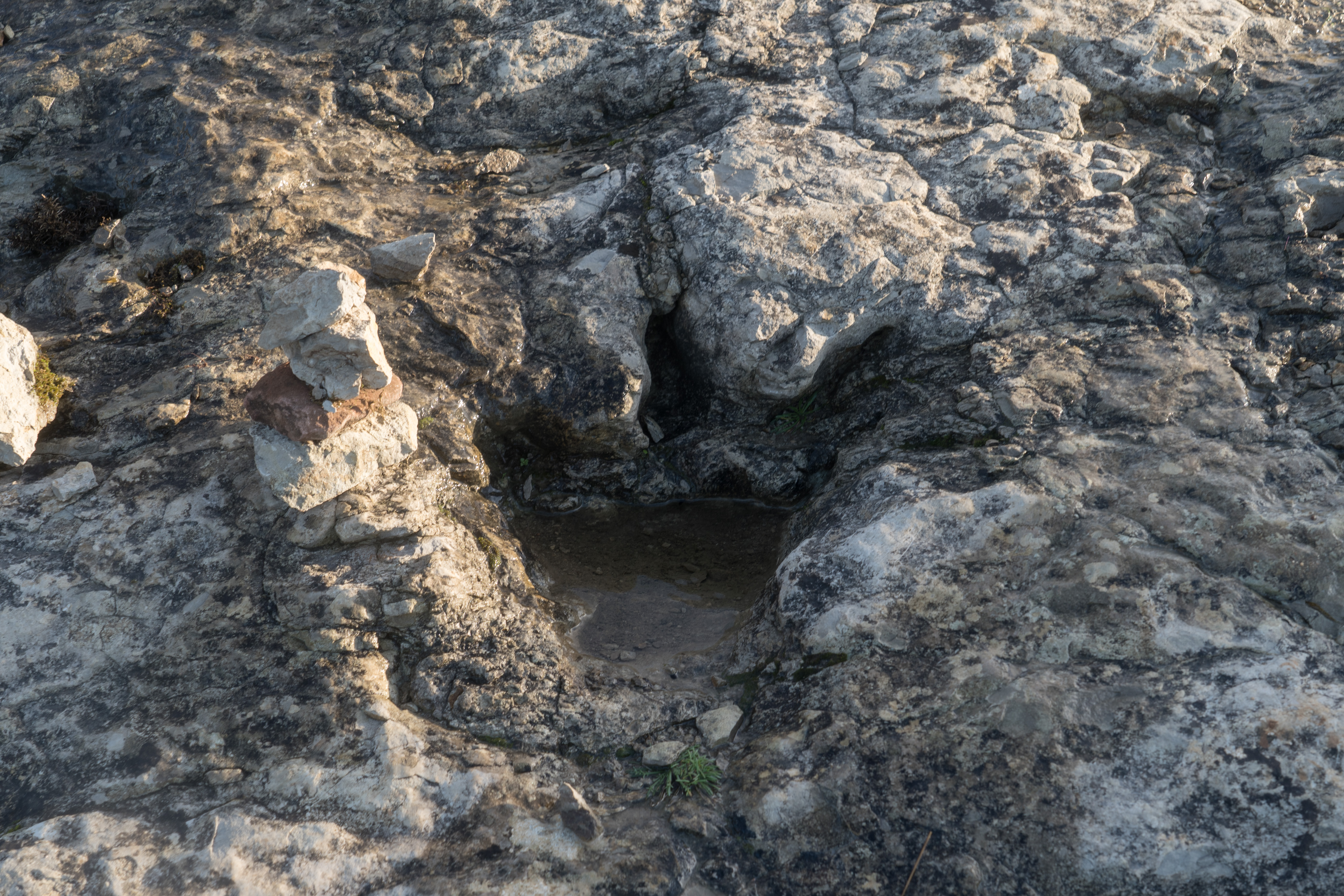
The same Jurassic limestone that shapes the bay preserves another feature worth the walk: dinosaur trackways. The outer-facing cliffs of the northern headland contain a set of theropod footprints — meat-eating bipedal dinosaurs, roughly Jurassic in age — impressed into the limestone when it was soft marine mud. The largest prints are roughly 35 cm across. They are visible at low tide along the exposed rock platform, best accessed from the Farol do Cabo do Ouivro trail with a local guide or in the company of someone who has been before. Portugal's Jurassic coast — which extends from Peniche through Lourinhã to Cabo Mondego — is one of the richest dinosaur-footprint regions in Europe. São Martinho is on it.
A theropod dinosaur footprint in the Late Jurassic limestone of the bay's outer cliffs. Roughly 150 million years old. December 2025.· Alexkom000
· Three Parts of the Bay
The beach, the headland, the estuary
The bay reads as one continuous shoreline from the Avenida Marginal. On the ground it's three distinct places with three different purposes.
The bay's inside curve at full attendance — Portuguese families, striped beach tents (tendas), the same summer practice the town has seen for a hundred and thirty years.· Vitor Oliveira (Torres Vedras)
PRAIA
Praia de São Martinho
The main beach — the inside curve of the shell. 2 km of white sand, calm water, very family-oriented. Lifeguarded June through September. Striped traditional beach tents (*tendas*) available for rent by the day or week.
Best for
Swimming with young children, paddle boats, first-time ocean visitors, the classic Portuguese summer-beach day
NORTE
Northern headland (Ouivro)
The rocky promontory at the bay's northern edge. A walking path leads up from the beach to the Farol (lighthouse) and the old whale-watching lookout. The exposed outside-of-the-bay water here is genuine Atlantic — rough, cold, not swimmable. The views back down into the bay are the source of most of the iconic photographs.
Best for
Sunset walks, panoramic photos, seeing the geometry of the bay
Local note
The path requires moderate walking shoes and is not suitable for strollers.
SALIR
Salir do Porto (southern end)
The sandbar and small wetlands at the bay's southern end — the estuary of the Alcobaça river system. A protected natural area. Partially swimmable at high tide; more interesting for birdwatching (egrets, herons, occasional flamingos in winter) than for beach activity.
Best for
Birdwatching, wetland walks, quieter sand
Local note
Respect the protected-area markers; do not take shells, sand, or plants.
· A Day Here
The Portuguese family beach day, still
Sunset over the bay, November. The southwest-facing shore catches the winter light for a long hour.· Alexkom000
Dawn
The fishing boats in the bay haven't entirely gone. Three or four small traineiras still work out of the Porto de Pesca at the southern end of the beach; they leave before first light, return by mid-morning. The Avenida Marginal is empty at 6 a.m. — the bakeries open at 7, the cafés at 8.
Midday
By eleven the beach is full. Portuguese families, mostly — striped beach tents (*tendas*), portable gas camping stoves for midday lunch, umbrella rows. Children in the water from 11 to 1, lunch on the sand, a second swim session in the afternoon. The calm water means parents are genuinely at ease; the vigilance needed on Atlantic beaches is not needed here. This is the bay's function.
Golden
Late afternoon the light on the southern headland turns bronze; the ferry-style tourist boat (*Pôr-do-Sol*) does a loop of the bay at €10 per adult. The cafés along Avenida Marginal fill. Portuguese families do the late-afternoon *passeio* along the boardwalk. Dinner in the village restaurants starts at 7:30 and runs late.
Night
Quieter than Nazaré or Peniche by an order of magnitude. A half-dozen restaurants and bars active past 11 p.m.; one or two clubs operate weekends in summer. The beach empties completely after sunset. The cafés on the praça stay open for the Portuguese tradition of after-dinner coffee and conversation. By midnight the town is mostly asleep.
· History
Seven points from the Romans to the dunes
The bay has been a functioning harbor for two thousand years. The seven dates below are the ones that shaped the São Martinho a visitor meets today.
100 BCE · cultural
Roman-era use of the bay
Archaeological evidence (amphora fragments, a small Roman-era salting facility at the southern headland) indicates the bay was in use as a harbor and fishery during the late Roman Republic and early Empire. The bay's natural shelter from Atlantic swell made it a reliable anchorage in a coast that otherwise offered almost none.
1153 · political
Coutos de Alcobaça established
King Afonso Henriques grants the Cistercian monks of Alcobaça a vast coastal territory — the Coutos de Alcobaça — that includes São Martinho's bay. The monks develop the coastal fishery and the salt-pans that will sustain the region for six centuries.
The 1 November 1755 earthquake — one of Europe's defining natural disasters — generated Atlantic tsunamis that reshaped stretches of the Portuguese coast. São Martinho's shell-bay geometry dampened the tsunami's local effect compared to open-coast sections; the neighboring Praia do Norte area at Nazaré was severely impacted. The bay has not significantly changed shape since.
The Linha do Oeste railway branch reaches the bay, connecting São Martinho to Caldas da Rainha and, through there, to Lisbon. The town becomes a summer resort for Portuguese middle-class families almost immediately. Early-20th-century hotel and villa construction along Avenida Marginal dates to the generation after this connection.
The small chapel at the bay's edge — dedicated to Martin of Tours, the town's patron — is rebuilt in its current form after an earlier structure was damaged. The chapel remains the ceremonial center of the town's November 11 Festa de São Martinho.
1970 · infrastructure
Salir do Porto bar dredging
Dredging at the Salir do Porto estuary (southern end of the bay) reshapes the sandbar in an attempt to improve water flow. The project is now widely regarded as having damaged the estuary's ecology; the bar and wetlands have been under protection status since the 1990s.
2013 · political
Municipal protected-area status
The Alcobaça municipality formally designates the Salir do Porto dunes and the bay's surrounding cliffs as protected natural heritage, tightening development restrictions. The bay's postcard identity is now municipally codified.
· In the Culture
Three inheritances that still define the town
The Cistercians of Alcobaça, since 1153
São Martinho's modern identity is younger than its economy. From the mid-12th century until the dissolution of Portuguese religious orders in 1834, the bay and its fisheries were worked under the jurisdiction of the Cistercian monastery at Alcobaça — a monastery whose founding charter (granted by King Afonso Henriques in 1153) ceded the monks a vast coastal territory known as the Coutos de Alcobaça. The Cistercians built salt pans, organized the fishing fleet, codified the share system that distributed the catch among the village's families, and for six hundred years were the institution the bay answered to. The municipal boundary of Alcobaça today — which still includes São Martinho, Nazaré, and a dozen other towns — follows the old couto lines. When you visit the UNESCO-listed Alcobaça monastery twenty kilometers inland and see the full extent of the medieval land grant painted on the cloister walls, you are looking at the jurisdictional geometry that made São Martinho what it became.
The tile-fronted houses of the village core — late-19th- and early-20th-century Portuguese seaside vernacular, built in the generation after the 1887 railway arrived.· Alexkom000
The 1887 railway — Portugal's first seaside resort
The railway that reached São Martinho in 1887 — the Linha do Oeste, connecting Lisbon to Leiria via the Silver Coast — was the second transformation. Within a generation the village's economy shifted from fishing and salt to summer tourism for the Portuguese middle class. The tile-fronted two-story houses that still line Avenida Marginal are the architecture of that transformation — Portuguese seaside vernacular built between approximately 1890 and 1930, roughly contemporary with Nice's Promenade des Anglais and Brighton's early-Victorian squares. São Martinho is one of the oldest continuously-operating seaside resorts in Portugal. Most of its current visitor infrastructure dates to that period; most of its current vacationers are fourth-generation descendants of the families who built it.
The windmills and the working hinterland
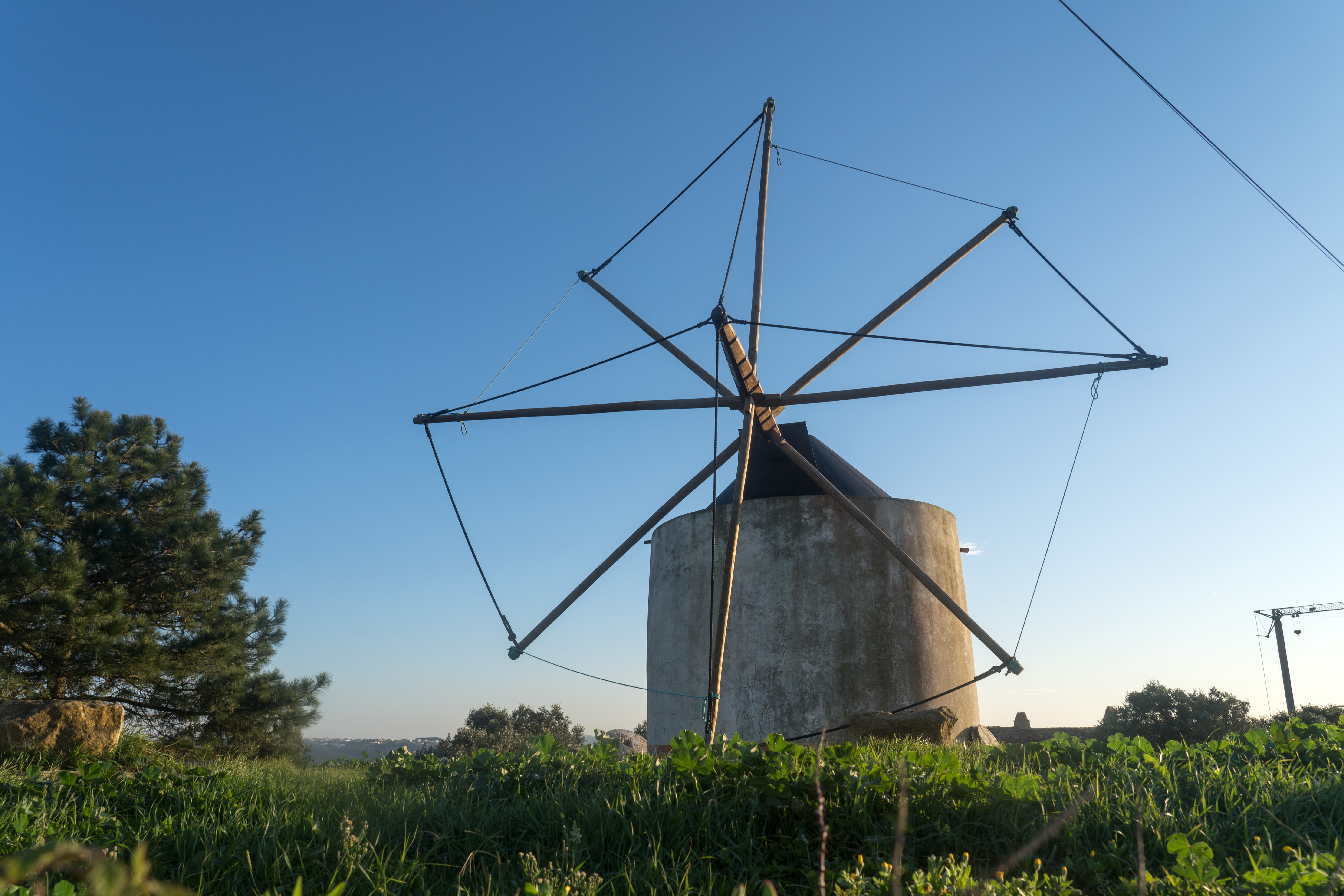
The hills immediately inland from the bay carry the town's third visible inheritance: a set of traditional Portuguese windmills (moinhos de vento) that ground grain for the coastal settlements from the 17th through the early 20th centuries. Several still stand, restored or semi-restored; one or two still turn on windy days. They are the reminder that São Martinho was never only a beach — it was the coastal face of an agricultural hinterland that extended inland to Alcobaça and beyond, and that hinterland is still there. Drive ten minutes inland and you are in Portuguese wine country: the Bairrada is a half-hour north, the Óbidos micro-region is a half-hour south, and the DOC Lourinhã — one of only three wine regions in the world formally classified for brandy production — is twenty minutes south.
A traditional windmill on the hills above the bay — 17th- to 19th-century Portuguese coastal agricultural technology. The hinterland São Martinho served as a port for.· Alexkom000
· What the Postcard Doesn't Show
The quieter pressures on a quieter bay
São Martinho is, unlike Nazaré, not a beach in crisis. But every Portuguese coastal town carries similar strains at different magnitudes. The ones here are worth naming.
São Martinho is, unlike Nazaré, not a beach in conflict with its tourism.
The town is small (roughly 3,000 year-round residents); the geography limits how much beachfront development is possible; and the bay's calm-water identity self-selects for a family-and-retired-Portuguese visitor base rather than the international surf-tourism crowd that changed Nazaré. Hotel development along Avenida Marginal has been cautious through the 20th century, and the Câmara Municipal de Alcobaça has historically enforced height limits tighter than Nazaré's. The result is a town whose shoreline still looks recognizably like it looked in 1950.
The tensions that do exist are quieter. The bay's closed geometry means water quality is more delicate than an open-Atlantic beach — the same feature that makes the water swimmable also makes it slower to flush, and there are occasional summer advisories when heavy rain or broken sewer infrastructure temporarily contaminates it. The Salir do Porto estuary at the bay's southern end — a small wetlands and sandbar — has been under chronic protection-vs-development argument for decades; the bar was partially reshaped by dredging in the 1970s and the estuary has not entirely recovered.
And there is housing pressure, softer than Nazaré's but real: the second-home market for Lisbon families has kept permanent-resident affordability strained. A small-town Portuguese service-sector worker increasingly cannot live in the town where they work. This is not a São Martinho problem specifically — it is every Portuguese coastal town problem — but it is the mechanism by which the quiet old resort becomes, over time, a less-lived-in place.
The big-wave capital. Same coast, opposite character. Nazaré's Praia do Norte is where the world's largest surfable waves break in winter; the village is where the 900-year Marian pilgrimage happens every September 8. A half-day from São Martinho; a full cluster of its own.
12 km inland
Alcobaça Monastery
The 12th-century Cistercian monastery whose monks ran the São Martinho bay for six centuries. UNESCO World Heritage site. Inside: the tombs of Dom Pedro I and Inês de Castro, facing each other — the central tragedy of medieval Portuguese literature. The monastery is the inland institutional anchor that São Martinho is the coastal face of.
25 km south
Óbidos
The walled medieval town given as a wedding gift by Dom Dinis to his queen in the 13th century and retained as the queens' property of Portugal for 650 years. Walk the ramparts; drink the ginjinha — sour cherry liqueur served in a chocolate cup you eat afterwards.
45 km south
Peniche & Supertubos
Portugal's WSL Championship Tour surf break — the MEO Pro runs here each October. Fast, hollow, barrelling beach break that produces some of the cleanest tubes in Europe. The Berlengas Islands (a nature reserve 10 km offshore) are worth a boat day if you stay overnight.
Written by Erin Rose. Historical material on the Coutos de Alcobaça follows Gonçalves (1989) O Mosteiro de Alcobaça e a Costa. Jurassic footprint material draws on the Lourinhã Museum's fieldwork catalogue for the region. Climate and ocean data from IPMA (Instituto Português do Mar e da Atmosfera). Images from Wikimedia Commons, per-image attribution in-line. Version v0.9. Corrections welcome, particularly on specific named-practice detail at the estendal of Salir do Porto and the current status of the Jurassic footprint guided-visit program.