Whitsunday Island - Whitehaven Beach 02.jpg

Queensland, AU

Whitehaven Beach

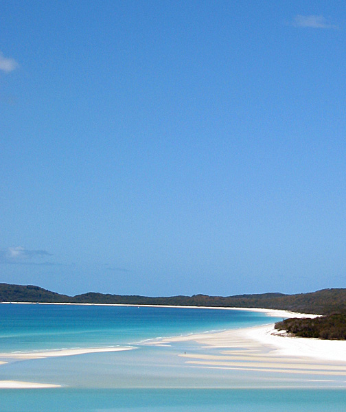
Seven kilometres of 98% silica sand so pure it squeaks underfoot and stays cool in full sun, with no local quartz source to explain it.

Whitsunday Island - Whitehaven Beach 02.jpg · <a rel="nofollow" class="external text" href="https://www.flickr.com/people/63906808@N00">Damien Dempsey</a> from Melbourne, Australia · CC BY 2.0
Length
12.0 km
Spring tide
2.84 m
Nearest airport
HTI · 12 km
Tier
Featured
I’m here for
Story

Whitehaven Beach runs about seven kilometres along the eastern side of Whitsunday Island, the largest of the Whitsunday group off the central Queensland coast. The island sits inside Whitsunday Islands National Park, gazetted in 1944 and now about 170 square kilometres managed by the Queensland Parks and Wildlife Service. There is no road and no resort on it. You reach it by boat, sailing catamaran, seaplane, or helicopter from Airlie Beach or Hamilton Island, and leave the same day unless you hold a national-park camping permit for the foredune sites.

The sand is the reason it is famous, and the reason is specific: about 98 percent pure silica, fine and bright white, behaving unlike ordinary beach sand. It squeaks underfoot as the grains rub together. It reflects sunlight rather than absorbing it, so it stays cool enough to cross barefoot at midday when darker beaches would burn, and it barely sticks to wet skin. The strange part is that there is no quartz in the surrounding rock to have produced it. Geologists generally hold that the silica was carried here over millions of years by ocean currents, weathered from quartz-rich rock somewhere else and deposited on this one stretch of shore.

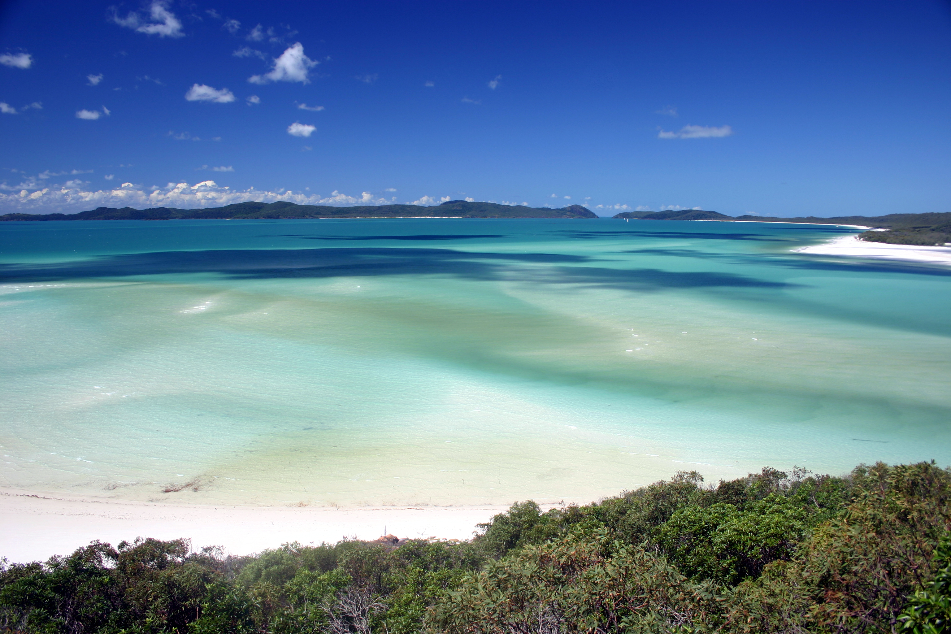
At the northern end the beach opens into Hill Inlet, a tidal channel where white sand and shallow water shift against each other with every tide, dragging the silica into pale ribbons through turquoise and deeper blue that are never the same twice. The standard view is from the Hill Inlet Lookout, reached on a 1.3-kilometre return track from Tongue Point. Most day tours stop at both the lookout and the main beach.

This is Ngaro Sea Country. The Ngaro, the saltwater people, lived and travelled across these islands for thousands of years before Europeans arrived, crossing the water in bark canoes. James Cook sailed through in June 1770, named the channel the Whitsunday Passage and the group the Cumberland Isles, and recorded nothing of the people already there. The beach was named Whitehaven in 1879 by Staff Commander E. P. Bedwell of the Royal Navy, after the town in England. The Ngaro and Gia peoples are the recognised traditional owners today.

Whitehaven is also the polished front edge of a system in trouble. It is a gateway to the Great Barrier Reef, and the reef has bleached at mass scale five times in eight summers — 2016, 2017, 2020, 2022 and 2024 — under ocean heat that 2024 research found to be the highest in four centuries. The beach can hold a few hundred day-trippers on a calm winter morning and look untouched, but the no-development rules that keep it that way are a deliberate constraint, and the reef the boats cross to reach it is not in the shape the brochures imply.

The spike

Seven kilometres of 98% silica sand so pure it squeaks underfoot and stays cool in full sun, with no local quartz source to explain it.

The spike at Whitehaven is the sand, and to understand why it earns a place of its own you have to start with what most beach sand actually is. The ordinary sand under most feet in the world is a mongrel: crushed coral and shell, fragments of volcanic rock, quartz mixed with feldspar and mica and iron-bearing minerals that tint it cream, tan, grey, or pink. Whitehaven is not that. It is about 98 percent pure silica — silicon dioxide, the same compound as quartz and window glass — and the consequences of that purity are physical, not poetic.

Why it is white. Pure silica grains are clear to milky and reflect light across the spectrum rather than absorbing particular wavelengths the way iron-stained or organic-rich sand does. A beach this close to monochrome silica behaves almost like a diffuse mirror under the tropical sun, which is why Whitehaven reads as a hard, bright white that photographs as overexposed even when your eyes are squinting at the real thing. There is no coral or shell debris diluting it, because the beach is shaped by silica deposition rather than by a reef grinding itself down at its edge.

Why it stays cool. This is the detail that surprises people who have burned their feet on tropical sand elsewhere. Quartz has a relatively low capacity to store heat, and the grains here are so fine and so reflective that they bounce most of the incoming solar energy back rather than soaking it in. The result is sand you can walk on barefoot at noon when a darker, mineral-rich beach a few hundred kilometres away would be scalding. The same fineness means the grains barely cling to wet skin; you come out of the water and most of it falls away.

Why it squeaks. The grains are extremely fine, well-rounded, and very uniform in size and composition. When you walk on dry silica sand of that uniformity, the grains slide and rub against one another in a way that releases a short, high squeak — sometimes called singing or squeaking sand. It is a property of clean, sorted, near-spherical quartz, and it is one of the most direct sensory proofs that you are standing on something close to pure mineral rather than a mixed beach.

Where it came from — and the honest gap. Here is the part the marketing skips. There is no quartz-rich rock on Whitsunday Island, or in the immediate surrounds, that could have weathered down to produce a seven-kilometre run of nearly pure silica. The Whitsundays are largely volcanic in origin. So the sand had to arrive from somewhere else. The prevailing explanation is that the silica was eroded from quartz-bearing rock far away, then transported over millions of years by ocean currents and deposited on this particular stretch of coast, where the geometry of the island and the water held it. It is worth being precise: this is a well-supported interpretation, not a closed case, and you will see it stated with more confidence on tour brochures than the geology strictly warrants. The mystery is real, and it is more interesting than the certainty.

Hill Inlet: the sand as a moving thing. At the northern end the beach is not a static white line but a tidal system. Hill Inlet is a shallow channel where the silica and the seawater are pushed and pulled twice a day. On the falling tide the white sand emerges in banks and ribbons; on the rising tide the water floods back over it. Because the sand is so pale and the water so clear, the boundary between them becomes a visible, shifting map of turquoise, mint, and deep blue, and that map is genuinely never the same on two visits — it reorganises with the tide height, the wind, and the angle of the light. The canonical view is from above, at the Hill Inlet Lookout reached on the 1.3-kilometre return track from Tongue Point, because the swirl only resolves into a pattern when you are looking down on it. At water level you are standing inside the pattern and cannot read it. This is why the lookout, not the beach, is the photograph everyone has seen.

The no-shoes, no-development ethos. The character of the place is enforced by what is not allowed. There is no hotel, no bar, no shop, no permanent structure for commerce on the beach. Facilities amount to composting toilets, picnic tables, and the national-park camping sites in the foredunes. Day-trippers arrive by boat or seaplane and leave; campers carry in and carry out. The cool, fine sand makes shoes pointless, and the rules make development impossible, and those two facts reinforce each other into the experience the beach is sold on. It is one of the few places where the absence of infrastructure is the product.

Ngaro Country and the reef tension. None of this is empty land. This is Ngaro Sea Country — the saltwater people navigated and lived across these islands for thousands of years, and the white beach was part of an inhabited seascape long before it was named after a town in Cumbria. And the beach is a gateway: the boats that carry visitors here also carry them out to the Great Barrier Reef, which has bleached at mass scale repeatedly in the last decade. The sand will likely outlast the argument, because it is mineral and effectively permanent on human timescales. The living reef that frames the postcard is the part that is not. Holding both of those truths at once — an almost geologically eternal beach in front of a dying reef — is the honest way to stand on Whitehaven.

Plage Whitesunday island.jpg
Culture

Where it shows up

Other
  • CNN top eco-friendly beach in the world (2010) · 2010
    CNN.com

    In July 2010 CNN.com named Whitehaven the top eco-friendly beach in the world, one of the rankings that cemented it as a global tourism icon and a fixture of Queensland marketing.

  • TripAdvisor top-five beaches worldwide (2014) · 2014
    TripAdvisor

    In 2014 TripAdvisor placed Whitehaven among its top five beaches in the world, part of a recurring run of 'world's best beach' rankings the beach is regularly cited in.

Brand & advertising
  • Forza Horizon 3 · 2016
    Playground Games

    Whitehaven Beach features in the Australia-set open-world racing game Forza Horizon 3, an example of the beach standing in as the visual shorthand for an idealised Australian coast.

History
  • Keep Australia Beautiful — Queensland's cleanest beach (2008) · 2008
    Keep Australia Beautiful

    Whitehaven was named Queensland's cleanest beach in the 2008 Keep Australia Beautiful awards, a recognition tied directly to its no-development, leave-no-trace management.

Whitsunday Island - Whitehaven Beach 01.jpg
History

What happened here

  1. cultural

    Ngaro Sea Country

    The Ngaro, the saltwater people, lived and travelled across the Whitsunday Islands for thousands of years before European arrival, crossing open water in bark canoes. The islands hold Ngaro stone quarries and rock art, evidence of one of the oldest maritime cultures on the Australian coast. The Ngaro and Gia peoples are the recognised traditional owners.

    Wikipedia →
  2. 1770historic

    Cook names the Whitsunday Passage

    In June 1770 James Cook sailed HMS Endeavour through the channel between the islands and the mainland, named it the Whitsunday Passage for the church festival, and named the group the Cumberland Isles. His charts recorded none of the Ngaro people already living there.

    Wikipedia →
  3. 1879historic

    Beach named Whitehaven

    Staff Commander E. P. Bedwell of the Royal Navy named the beach Whitehaven in 1879, after the town of Whitehaven in Cumberland, England, during hydrographic survey work along the Queensland coast.

    Wikipedia →
  4. 1944policy

    Whitsunday Islands National Park gazetted

    Whitsunday Island and surrounding islands were protected as Whitsunday Islands National Park in 1944, locking the land into roughly 170 square kilometres of parkland before the post-war Queensland resort boom and barring resort development on Whitehaven itself.

    Wikipedia →
  5. 2008tourism

    Named Queensland's cleanest beach

    Whitehaven was recognised as Queensland's cleanest beach in the 2008 Keep Australia Beautiful awards, an early marker of the conservation-led management that keeps it free of development.

    Wikipedia →
  6. 2009tourism

    First Whitehaven Beach Ocean Swim

    The Whitehaven Beach Ocean Swim, a roughly two-kilometre open-water swimming event, has been held on the beach in November each year since 2009, one of the few organised events permitted on the otherwise undeveloped sand.

    Wikipedia →
  7. 2010tourism

    CNN names it world's top eco-friendly beach

    In July 2010 CNN.com named Whitehaven the top eco-friendly beach in the world, one of a run of international rankings that turned the beach into a global tourism icon.

    Wikipedia →
  8. 2017disaster

    Cyclone Debbie strikes

    Severe Tropical Cyclone Debbie crossed the Whitsundays in March 2017, causing severe erosion and damage to Whitehaven Beach and a reminder that even silica sand is not beyond a changing climate's storms.

    Wikipedia →
  9. 2024environmental

    Fifth mass reef bleaching in eight summers

    In March 2024 authorities confirmed widespread coral bleaching on the Great Barrier Reef — the fifth mass event since 2016 (after 2016, 2017, 2020 and 2022) — under Coral Sea ocean heat that a 2024 Nature study found to be the highest in roughly four centuries.

    Wikipedia →
The honest part
The sand is effectively eternal; the reef the boats cross to reach it is not, and that is the contradiction you are standing in.

Whitehaven is the bright, durable foreground of a system under acute stress. It is marketed as a Great Barrier Reef gateway, and the reef behind that marketing has suffered mass coral bleaching five times in eight summers — 2016, 2017, 2020, 2022 and 2024 — under Coral Sea ocean temperatures that a 2024 study in Nature found to be the highest in roughly four centuries. The beach itself is silica and effectively permanent on any human timescale; the corals the day-boats cross to reach are not, and a visit here funds and depends on the same warming-driven tourism economy that the reef's decline is a symptom of. Cyclone Debbie tore at the beach in 2017, a reminder that even the sand is not beyond a changing climate's reach.

There is also the question of who the place belongs to and how many people it can hold. This is Ngaro and Gia Sea Country, inhabited and navigated for thousands of years before James Cook named the passage in 1770 and a naval officer named the beach after an English town in 1879; the European names on the charts sit on top of a dispossession the brochures rarely mention. The no-overnight-development rules and the national-park camping limits exist because an unmanaged Whitehaven would be loved into ruin — the constraint is the only reason it still looks the way the photographs promise.

Petrogale inornata 166097066.jpg
Anatomy

The shape of the place

Southern end and Chalkies (Haslewood Island)

10%

The quieter southern reach of the beach, away from the main landing. Across the channel on Haslewood Island, Chalkies Beach offers fringing-reef snorkelling on some tours.

Best for Escaping the central crowds; pairing the beach with reef snorkelling

Access depends on your operator and the tide; Chalkies is a separate landing across the water, not part of the main Whitehaven beach.

Main beach (central landing)

50%

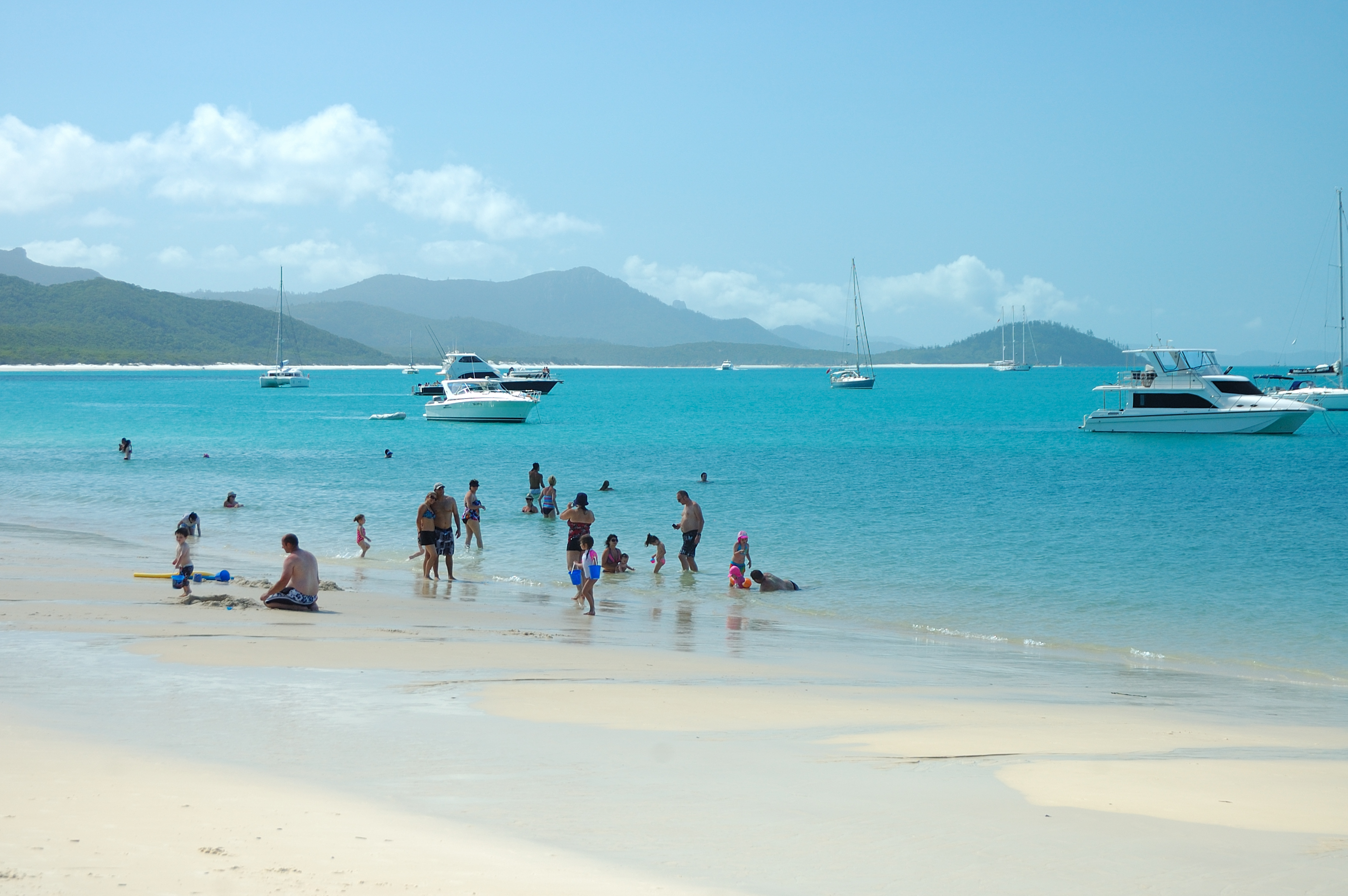
The wide central run of cool, squeaking white sand where most day tours land and swim. Composting toilets and picnic tables sit back in the foredunes; nothing is sold here.

Best for Swimming, walking barefoot on cool sand, the long white-sand panorama

The crowd concentrates here from late morning to early afternoon when the day boats arrive. Stinger suits in season; no shade and no shops.

Offshore anchorage

55%

The sheltered water off the central beach where day boats, bareboat charters, and sailing catamarans anchor and tender passengers ashore. There is no jetty or pier.

Best for Arriving by sail or charter; swimming off the boat

All landings are by tender or seaplane; there is no built infrastructure on the shore to tie up to.

Hill Inlet and Tongue Point Lookout

95%

The northern tidal channel where white silica and shallow water swirl into shifting ribbons of turquoise and blue, read from the lookout platform reached on a 1.3 km return track from Tongue Point.

Best for The classic aerial-style swirl view; photography at mid-to-low tide

The pattern only resolves from above and changes with every tide; at water level you are inside it and cannot see it. Plan around the tide chart, not the clock.

Landmarks

Hill Inlet Lookout (Tongue Point)

lookout · Queensland Parks and Wildlife Service

A national-park viewing platform above Hill Inlet at the northern end of the beach, reached on a 1.3 km return walking track from Tongue Point. It is the vantage point for the famous swirling sand-and-water pattern, which only resolves when seen from above.

Wikipedia →

Whitehaven Beach silica sand sheet

geological_formation

The roughly seven-kilometre body of about 98 percent pure silica sand that defines the beach. With no local quartz source, it is thought to have been carried here by ocean currents over millions of years and deposited on this stretch of the volcanic Whitsunday coast.

Wikipedia →

Whitsunday Islands National Park · 1944

protected_area · Queensland Parks and Wildlife Service

The roughly 170 km² national park, gazetted in 1944, that contains Whitsunday Island and bars resort development on Whitehaven, leaving only composting toilets, picnic tables, and permitted foredune camping.

Wikipedia →
A day here

From first light to dark

Dawn

The first boats have not left Airlie Beach or Hamilton Island yet, so the beach is effectively empty at first light. Campers on the foredune permits and the rare overnight charter have it to themselves. Low morning light rakes across the silica and the sand is cool underfoot before the sun is up. If the tide is falling, the Hill Inlet banks are emerging clean and unwalked.

Midday

This is the crowd peak. Day tours from Airlie Beach and Hamilton Island unload onto the main beach and the Hill Inlet Lookout track between roughly late morning and early afternoon, and the central stretch can hold a few hundred people. The light is hard and the white sand throws it straight back, so the beach photographs blown-out; the silica still stays cool to walk despite the overhead sun. Stinger suits are the dress code in season.

Golden hour

The day boats have a schedule to keep and most leave by mid-afternoon, so the beach empties out again before the best light arrives. Late afternoon brings warmer, lower sun, the turquoise deepens, and Hill Inlet's ribbons soften. The tide stage matters more than the hour: a low or falling tide late in the day exposes the most sand and the cleanest swirl.

Night

There is no nightlife here because there is no development. After the last boat the only people on a seven-kilometre beach are national-park campers in the foredune sites. No lights, no bar, no road — just the dark, the surf, and a sky with no light pollution from any settlement, because the nearest one is a boat ride away on the mainland.

Compare

How it ranks

Peak warmth
Warmer than 63% of beaches in its country
Peak-month high ≈ 29°C
Beach season
Longer beach season than 83% of beaches in its country
12 comfortable months a year

Ranked against every beach in our database — 228,000+ worldwide.

Whitsunday islands.jpg
Sea & surf

What the water does

JFMAMJJASONDmetres (significant wave height)

Solid = typical monthly wave height; pale = the bigger days (90th pct). Offshore/regional swell from Open-Meteo Marine (ERA5 Ocean reanalysis, 2023–2024); a sheltered cove may sit calmer than this.

Mixed — usually swimmable, with a livelier season
Typical wave height
0.67 m
Biggest swell
May · 0.82 m
Calmest
Jun · 0.49 m
Typical period
3.8 s (wind chop)
Before you go

Things to know

Leave the shoes on the boat

The silica sand reflects sunlight instead of soaking it up, so it stays cool enough to cross barefoot even at midday. Shoes are pointless on the beach itself; you'll want them on the rocky Hill Inlet Lookout track.

Wear the stinger suit in season

From roughly late October to May, box jellyfish and Irukandji are in these waters. There are no stinger nets out here — they're on the mainland beaches. Tours hand out full-body lycra stinger suits; wear one, even just to wade.

It's a national park — carry everything out

There are no shops, bins, or services on the beach, only composting toilets and picnic tables. Leave-no-trace rules apply: whatever you bring in, including food scraps and rubbish, you carry back out. Don't take the sand.

No road, no overnight resort

You can only arrive by boat, sailing charter, seaplane, or helicopter from Airlie Beach or Hamilton Island. There is no accommodation on the beach apart from permitted national-park camping in the foredunes; almost everyone visits as a day trip.

Sharks

No incidents on record in the global shark-attack file.

Plan

If you go

Getting there
Nearest airport
Hamilton Island Airport (HTI) · 12 km
Nearest town
Proserpine · 49 km

There is no road and no airstrip to Whitehaven. Reach it on a day trip from the mainland town of Airlie Beach or from Hamilton Island — by high-speed motorised boat, sailing catamaran, bareboat charter, seaplane, or helicopter, all of which anchor or land and tender passengers ashore. The only way to stay overnight is a Queensland Parks and Wildlife Service camping permit for the foredune sites, where you carry in all food and water; otherwise you leave on the same boat you arrived on.

When to go
  • Dry season (peak visiting months) · Roughly May to October

    The southern-hemisphere dry season brings the most settled weather, lower humidity, calmer water, and the heaviest day-tour traffic to Whitehaven. It falls largely outside the worst of stinger season, which is why most visitors come in these months.

  • Stinger season · Roughly late October to May

    Dangerous marine stingers — box jellyfish and the tiny Irukandji — are present in Whitsunday waters through the warmer months. There are no stinger nets at Whitehaven (the nets are on the mainland beaches), so tours issue full-body stinger suits, which cut the risk of a sting by around 75 percent.

  • Whitehaven Beach Ocean Swim · November, annually since 2009

    A roughly two-kilometre open-water swimming event held on the beach each November since 2009, and one of the only organised gatherings permitted on the otherwise rule-bound, undeveloped sand.

What to eat & drink
Nothing on the beach — bring it or it's on the boat

There is no shop, cafe, kiosk, or bar anywhere on Whitehaven. Day tours include lunch on board — typically a barbecue, tropical fruit, and cold drinks served from the vessel — and you carry everything else in and out. Campers must bring all food and water, as there is no supply on the island.

On your tour boat or carried in; the beach itself has only composting toilets and picnic tables.

Barramundi

Queensland's signature estuary and reef fish, served grilled or beer-battered across the coast. It is a fixture of Airlie Beach restaurants and of the better day-tour lunches that cater seafood.

Restaurants along the Airlie Beach esplanade and Port of Airlie, the mainland jumping-off point — not on Whitehaven.

Moreton Bay bugs

A flat, sweet Queensland slipper lobster, usually split and grilled with garlic butter. A regional delicacy that turns up on Whitsunday seafood platters and premium sailing-charter menus.

Seafood restaurants in Airlie Beach and on Hamilton Island; sometimes on higher-end charter lunches.

Tropical North Queensland mango and cold beer

Queensland mangoes ripen through the dry-season tourist months, and an XXXX or a local craft beer is the standard hot-day drink. Most day boats stock cold beer and the regional fruit for the trip out and back.

Served on the boats and across Airlie Beach; no alcohol is sold on the beach, and the national park has its own rules on what campers bring.

Go deeper
Sources & references
  1. Wikipedia: Whitehaven Beach · cited 6×
  2. Wikipedia: Whitsunday Islands National Park · cited 3×
  3. Wikipedia: Whitsunday Islands National Park; Ngaro people
  4. Wikipedia: Cumberland Islands (Queensland)
  5. Wikipedia: Whitehaven Beach; Cyclone Debbie
  6. WWF Australia; The Conversation; Nature (2024)
  7. Wikipedia: Whitehaven Beach; Sailing Whitsundays
  8. Tourism Whitsundays
  9. Wikipedia: Whitehaven Beach; Cumberland Islands (Queensland)
  10. WWF Australia; The Conversation; AIMS
Colophon · Provenance

Where this page comes from

Geography, facilities
OpenStreetMap (ODbL) for geometry and facility tags within 500 m of the beach centroid. GeoNames for city/airport distances.
Climate & ocean
worldclim_v2.1_2.5m
Tides
eot20
Photography
Archival, original tone (Tier B — Wikimedia Commons). Each image licensed per its own terms; attribution visible inline.
History & culture
Every factual claim is linked to its source in the prose above. Wikipedia citations inline. Non-wiki sources named where relevant.
Editorial voice
Register: reverent. Written to pass a local's nod test; corrections welcome.
Written by Erin Rose
Last reviewed 2026-04-19
v0.9in editorial development toward v1.0