Capital Region, DK

Amager Strandpark

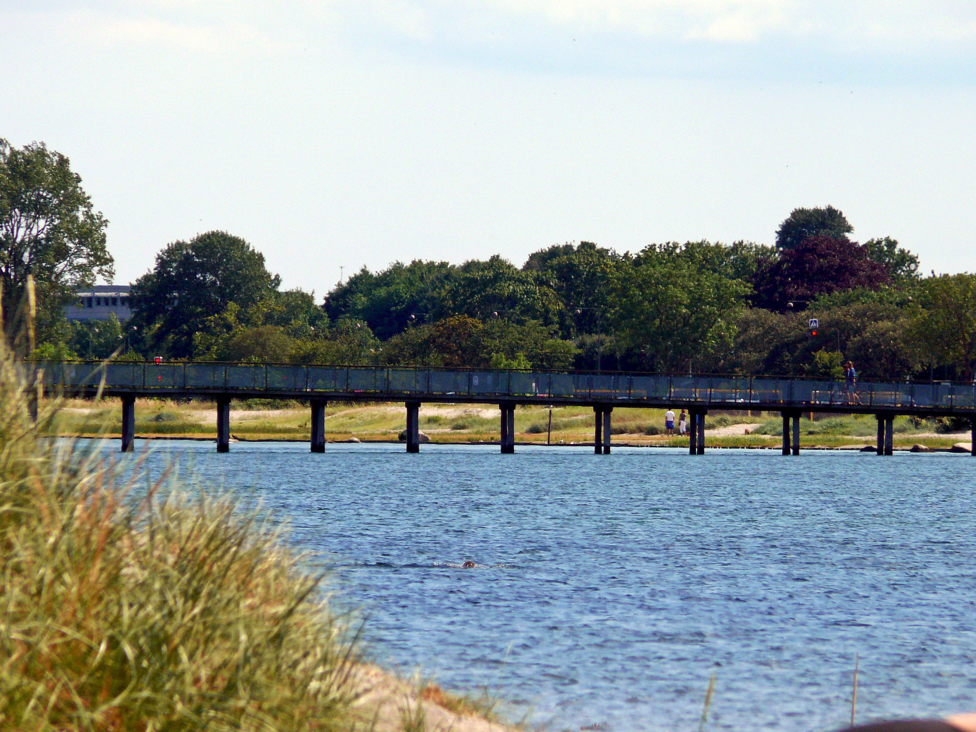
Amager Strandpark - bridge.jpg

Capital Region, DK

Amager Strandpark

Built in 2004-2005, Amager Strandpark is a 2 km man-made island that turns the strait into a shallow lagoon, with a metro line opened in 2007 to bring the city to it.

Amager Strandpark - bridge.jpg · <a rel="nofollow" class="external text" href="https://www.flickr.com/people/64304748@N07">Chris Alban Hansen</a> from Copenhagen, Denmark · CC BY-SA 2.0
Spring tide
0.09 m
Nearest airport
CPH · 4 km
Tier
Featured
I’m here for
Story

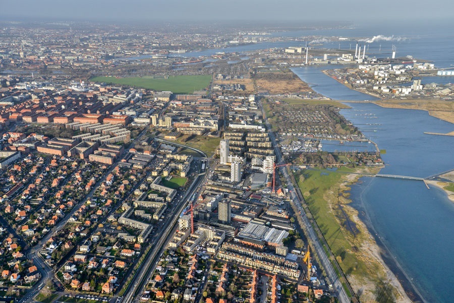
Amager Strandpark is not a natural beach. It is a piece of engineering that looks like one. The sand, the dunes, and the 2 km island you walk along were designed and built between 2004 and 2005 by the Copenhagen firm Hasløv & Kjærsgaard, with engineering by Niras and construction by Hoffmann A/S. Roughly 1.5 million cubic metres of material were moved to make a barrier island sitting offshore of the old shoreline, and the channel between the two was kept as a shallow lagoon crossed by three bridges. The total run of beach is about 4.6 km on a site of around 60 hectares, on the eastern edge of Amager, four kilometres from the city centre.

There was a beach here before. The first Amager Strandpark opened in 1934 on reclaimed land, partly over an old landfill. By the 1990s it was eroding and its water was not reliably clean. The 2005 rebuild did not restore it so much as replace it with a better machine: the offshore island takes the weather, and the lagoon behind it stays shallow, calm, and warm enough for children. The northern third was shaped into a duned 'landscape beach'; the southern two-thirds is a 'city beach' with a hard promenade, squares, and a 1,000-metre marked swimming course in the lagoon.

The view off the water is industrial and Scandinavian at once. Straight out, the twenty turbines of the Middelgrunden wind farm stand in a curved line on a shoal about 3.5 km offshore — among the first big offshore wind farms in the world when it went up in 2000. To the south you can see the Øresund Bridge running to Sweden, and on a clear day the Swedish coast itself. The horizon here is a bridge, a wind farm, and a foreign country.

What actually made this Copenhagen's beach was not the sand but the metro. The M2 line's eastern Amager branch — stations at Øresund, Femøren, and Amager Strand — opened on 28 September 2007, two years after the beach, putting the lagoon about fifteen minutes from the centre with no car. A purpose-built beach is only a city beach if the city can reach it, and after 2007 it could, in numbers reaching tens of thousands on a hot day. At the northern tip sits Helgoland, a cluster of patented turquoise timber bathing houses on stilts, home to one of the world's oldest winter-bathing clubs, Det Kolde Gys ('The Cold Thrill'), founded in 1929. Year-round, in water that drops to 3-5°C in winter, members sauna and then walk into the Øresund on purpose.

What Amager Strandpark proves is narrow and real: a city can manufacture a working beach if it will build an island, dig a lagoon, and run a train to it. The result is genuinely good — clean most of the year, swimmable, busy, free. It is also, every metre of it, made by people, and the park does not pretend otherwise.

The spike

Built in 2004-2005, Amager Strandpark is a 2 km man-made island that turns the strait into a shallow lagoon, with a metro line opened in 2007 to bring the city to it.

Amager Strandpark is the rare beach whose entire identity is that it was designed. Most legendary beaches are accidents of geology that humans then crowded; this one is a deliberate object, drawn by a named firm, priced, engineered, and built to a deadline. Understanding it means understanding the machine, not the myth.

The island and the lagoon are the whole idea. Before 2005 the old 1934 beach faced the open Øresund directly, which meant it took the weather, lost sand to erosion, and offered no shelter. Hasløv & Kjærsgaard's solution was to build a second, artificial barrier island roughly 2 km long, sitting offshore and parallel to the old shoreline, and to keep the channel between the two as a lagoon. The lagoon is the point. Because the new island absorbs the wind and chop coming off the strait, the water trapped behind it stays shallow, calm, and a few degrees warmer than the open sea — ideal for children and weak swimmers, with low-water play areas and a marked 1,000-metre swimming course. Three bridges cross from the old shore to the island so the public can walk out onto the seaward side, where the water is rougher and the windsurfers and kitesurfers work. One geography, two beaches: a sheltered domestic lagoon on the inside, an exposed sporting coast on the outside.

The numbers are construction numbers, not natural ones. The project moved on the order of 1.5 million cubic metres of raw material over a build of roughly eighteen months in 2004-2005. The site covers about 60 hectares and runs to about 4.6 km of total beach. Engineering was by Niras; the main contractor was Hoffmann A/S; the client side involved the City of Copenhagen and the dedicated Amager Strandpark organisation. Sources disagree on the headline cost: figures cited range from about €25 million to about €33 million (roughly 200 million Danish kroner), and the discrepancy is worth stating plainly rather than splitting — different sources draw the project boundary differently. What is not in dispute is the order of magnitude: this is a beach that cost a public infrastructure budget to make.

The 1934 ancestor matters. Amager Strandpark did not appear on virgin coast. The original beach park opened in 1934 as a Depression-era public works and bathing facility on reclaimed and partly reclaimed land — part of it built over an old landfill. That first beach gave generations of Copenhageners somewhere to swim, but by the 1990s it was eroding and its water quality was unreliable. The 2005 project is best read not as creation from nothing but as a teardown-and-rebuild of an existing 70-year-old artificial beach into a more durable, better-sheltered one. The dunes you see in the northern 'landscape beach' are planted and shaped, not inherited.

The metro is the hidden half of the design. A purpose-built city beach is useless if the city cannot get to it cheaply. The decisive infrastructure was not the sand but the Copenhagen Metro's M2 eastern Amager branch, whose stations at Øresund, Femøren, and Amager Strand opened on 28 September 2007 — two years after the beach itself. (A common claim that the line 'opened in 2002 to serve the park' conflates the M2's first 2002 stages with this 2007 branch; the section actually serving Amager Strandpark opened in 2007.) From 2007 the lagoon was about fifteen minutes from the centre with no car, and the day-tripper numbers that justify a beach this size — up to around 40,000 visitors on a hot day — became possible. The beach and the railway are a single system; one without the other is half a project.

The view is the argument in one frame. Stand on the seaward side and look out: the twenty turbines of the Middelgrunden wind farm in their curved line on a shoal 3.5 km offshore (built 2000, then among the largest offshore wind farms in the world), the Øresund Bridge carrying trains and cars to Malmö to the south, and the Swedish coast across the strait. Almost nothing in that view is older than the beach, and almost all of it is engineered. Amager Strandpark is the only major European city beach where the postcard is a wind farm and a transnational bridge, and that is exactly right, because the beach in the foreground is built too.

The oldest thing here is a habit, not a place. At the northern tip, the Helgoland bathing house — turquoise timber pavilions on stilts, the colour patented — hosts Det Kolde Gys, founded 1929, one of the world's oldest winter-bathing associations. Through a Copenhagen winter, members sweat in the sauna and then walk into 3-5°C Øresund water deliberately. The Helgoland structures themselves are recent at this location, but the ritual is the one genuinely old thing on the site, and it is cultural, not geological. That is the final tell about what makes Amager Strandpark singular: it is a beach whose sand was delivered by truck and whose deepest tradition is a swimming club. It is honest engineering pretending to be nothing.

Amager strandpark.jpg
Culture

Where it shows up

History
  • Det Kolde Gys winter-bathing club · 1929
    Vikingeforeningen Det Kolde Gys

    One of the world's oldest winter-bathing associations, founded 1929, now based at Helgoland on the northern tip of Amager Strand. Members sauna and then plunge into 3-5°C Øresund water through the Copenhagen winter — the oldest living tradition on the beach.

Film
  • The Olsen Gang's Big Score (Olsen-banden går amok) · 1973
    Erik Balling

    An entry in the long-running Danish 'Olsen Gang' comedy caper series uses the Helgoland sea-bath as a location. A modest but real screen appearance for the bathing house that anchors the northern end of the beach.

Other
  • Hasløv & Kjærsgaard's Amager Beach Park · 2005
    Hasløv & Kjærsgaard

    The beach as a recognised work of landscape architecture — widely published in the field (Landezine, the Danish Architecture Center) as a case study in building an urban beach and 'engineered nature' rather than restoring a natural one.

Amager strandpark parkrun Copenhagen Denmark 5June2023.jpg
History

What happened here

  1. 1934development

    Original Amager Strandpark opens

    The first Amager Strandpark opens as a public bathing park on reclaimed land on the eastern edge of Amager, partly over former landfill — a Depression-era public works giving Copenhageners a city beach. This 1930s beach is the ancestor the 2005 project would replace.

    Wikipedia →
  2. 2000infrastructure

    Middelgrunden wind farm goes up offshore

    The 20-turbine Middelgrunden wind farm is completed on a shoal in the Øresund about 3.5 km off Copenhagen — at the time among the largest offshore wind farms in the world. Its curved line of turbines becomes the permanent seaward view from the beach built five years later.

    Wikipedia →
  3. 2004development

    Construction of the artificial island begins

    Work begins on the rebuilt park: Hasløv & Kjærsgaard's design for a roughly 2 km artificial barrier island and the lagoon behind it, engineered by Niras and built by Hoffmann A/S. About 1.5 million cubic metres of material are moved over a build of around eighteen months.

  4. 2005development

    Rebuilt Amager Strandpark opens

    The new Amager Strandpark opens — a 2 km man-made island, a sheltered lagoon crossed by three bridges, a northern duned 'landscape beach' and a southern 'city beach' with promenade and a 1,000-metre swimming course, about 4.6 km of beach over ~60 hectares.

    Wikipedia →
  5. 2007infrastructure

    M2 metro branch opens to the beach

    On 28 September 2007 the Copenhagen Metro's M2 eastern Amager branch opens, with stations at Øresund, Femøren and Amager Strand directly serving the park — the infrastructure that turns a purpose-built beach into a true city beach about fifteen minutes from the centre.

    Wikipedia →
  6. 2008cultural

    Helgoland bathing house at its current Amager site

    The Helgoland sea-bathing house — turquoise timber pavilions on stilts — is established at its current location by Amager Strand, hosting the winter-bathing club Det Kolde Gys (founded 1929). The structures are recent here; the cold-water ritual is the oldest tradition on the beach.

  7. 2011policy

    Cloudburst exposes the sewer-overflow risk

    A record Copenhagen cloudburst overwhelms the city's combined sewers, sending stormwater and sewage toward the harbour and coast — the recurring hazard behind Amager Strandpark's post-rain bathing warnings. The city and utility HOFOR respond with large underground retention reservoirs and a 24-hour overflow warning system.

The honest part
The sand was delivered, the lagoon was dug, and the metro was built to bring you here — it is a genuinely good beach, and it is entirely man-made.

The honest thing to say about Amager Strandpark is that it is entirely man-made, and its problems are the problems of a city beach. The water carries an EU 'excellent' bathing rating most of the time, but Copenhagen still runs a combined sewer system in places, and in heavy rain the system overflows — a mix of stormwater and untreated sewage spills toward the harbour and coast. The city and its utility HOFOR built large underground retention reservoirs to reduce this, and run a warning system that posts bathing alerts during and for up to 24 hours after an overflow. The practical rule is simple: after a serious downpour, check the official bathing-water status before you swim, and assume the lagoon may be temporarily closed. On top of that, the Øresund gets seasonal jellyfish — moon jellies and the stinging lion's mane appear in summer and autumn, more in some years than others — and the beach is genuinely wind-exposed, which is why kitesurfers love the seaward side and why a calm-looking lagoon day can turn cold and blustery fast. None of this is hidden, and none of it is unusual for a northern-European urban beach. The larger point stands: this is not nature you stumbled on, it is infrastructure you were invited to. Calling it a beach is fair; calling it natural is not.

Amager Strandpark fra luften.jpg
Anatomy

The shape of the place

Landscape beach & Helgoland

12%

The northern third, shaped as a duned 'landscape beach', quieter and more naturalistic, ending at the Helgoland bathing house on the northern tip — home of the Det Kolde Gys winter-bathing club and the year-round sauna-and-cold-dip ritual.

Best for Winter bathing and sauna, quieter swimming, the planted dunes

The 'dunes' here are engineered and planted, not natural. Helgoland is the oldest cultural institution on the site.

The lagoon (sheltered side)

50%

The shallow, calm water trapped between the old shore and the artificial island, crossed by three bridges. Warmer and gentler than the open sea, with low-water play areas and a marked 1,000-metre swimming course. Where families and weak swimmers go.

Best for Children, lap swimming the marked course, calm-water bathing

This is the engineered heart of the design — the island exists to make this lagoon possible.

City beach & kayak club

80%

The southern two-thirds: a hard-edged 'city beach' with promenade, squares, kiosks and cafés, and a large kayak club with rentals and a sauna at the southern end of the island. The busiest, most urban stretch, fed by the M2 stations.

Best for Day-tripper crowds, food and cafés, kayaking, the promenade

The seaward (open-sea) side of the island here is where windsurfers and kitesurfers work the Øresund wind.

Landmarks

The artificial island & lagoon · 2005

engineered · Hasløv & Kjærsgaard (engineer Niras; contractor Hoffmann A/S)

The defining structure: a roughly 2 km man-made barrier island built in 2004-2005, sitting offshore of the old shoreline and trapping a sheltered lagoon behind it, crossed by three bridges. About 1.5 million cubic metres of material were moved to build it.

Wikipedia →

Helgoland bathing house

built · Carsten Hoff

Turquoise timber bathing pavilions on stilts at the northern tip, the colour patented, established at this Amager site around 2008. Home to Det Kolde Gys ('The Cold Thrill'), a winter-bathing club founded in 1929 and one of the oldest in the world.

Middelgrunden wind farm · 2000

infrastructure

Twenty offshore turbines in a curved line on a shoal about 3.5 km out in the Øresund, completed in 2000 and among the largest offshore wind farms in the world at the time. The permanent seaward landmark of the beach, half-owned by a citizens' cooperative.

Wikipedia →
A day here

From first light to dark

Dawn

Early, the lagoon is glass and the seaward side carries the Baltic chop. At Helgoland on the northern tip, Det Kolde Gys members are already in the sauna and the cold Øresund before work — in winter the water is 3-5°C and they go in deliberately. The Middelgrunden turbines turn on the horizon and the light is flat and grey-blue.

Midday

On a warm summer day the M2 delivers families in waves to Amager Strand, Femøren and Øresund stations, and the city beach fills along the promenade. The sheltered lagoon — shallow, calm, a touch warmer than the open sea — is where the children and casual swimmers go; the 1,000-metre marked course draws lap swimmers. The seaward side is for the wind.

Golden hour

Late afternoon the wind usually steadies and the seaward side of the island fills with windsurfers and kitesurfers working the Øresund breeze. The low sun puts the Øresund Bridge and the Swedish coast in silhouette to the south. The three bridges over the lagoon back up with cyclists heading home along the Amager paths.

Night

After dark the beach empties quickly and the promenade lights take over; the turbines blink red offshore and the bridge to Sweden is a lit line on the water. Helgoland keeps its own rhythm — the sauna and winter-bathing crowd come and go year-round — but the broad city beach is quiet, a built landscape returned to the wind and the gulls.

Compare

How it ranks

Peak warmth
Warmer than 94% of beaches in its country
Peak-month high ≈ 21°C

Ranked against every beach in our database — 228,000+ worldwide.

Amager Strandpark 2014.jpg
Sea & surf

What the water does

JFMAMJJASONDmetres (significant wave height)

Solid = typical monthly wave height; pale = the bigger days (90th pct). Offshore/regional swell from Open-Meteo Marine (ERA5 Ocean reanalysis, 2023–2024); a sheltered cove may sit calmer than this.

Calm — gentle swimming water most of the year
Typical wave height
0.57 m
Biggest swell
Jan · 0.79 m
Calmest
Jun · 0.4 m
Typical period
3.2 s (wind chop)
Before you go

Things to know

It is entirely man-made

Amager Strandpark is engineered, not natural — a 2 km artificial island and a dug lagoon built in 2004-2005, replacing a 1934 beach that was itself on reclaimed land. The dunes are planted. Come for a good city beach, not for wild nature.

Check the water after heavy rain

Copenhagen's combined sewers can overflow in downpours, sending stormwater and sewage coastward. The city posts bathing warnings during and for up to 24 hours after an overflow. After serious rain, check the official bathing-water status before swimming — the lagoon may be closed.

Wind and jellyfish

The seaward side is genuinely wind-exposed (which is why kitesurfers favour it) and a calm lagoon day can turn cold fast — bring layers. The Øresund gets seasonal jellyfish in summer and autumn, including the stinging lion's mane, heavier in some years than others.

Cold water, even in summer

This is the Baltic-influenced Øresund: water peaks around 17-18°C in high summer and drops to 3-5°C in winter. The sheltered lagoon is a touch warmer than the open sea, but a wetsuit is sensible outside July-August.

Swimming

Usually calm water — among the gentler beaches for a swim.

Sharks

No incidents on record in the global shark-attack file.

Plan

If you go

Getting there
Nearest airport
Copenhagen Kastrup Airport (CPH) · 4 km
Nearest town
Tarnby · 4 km

Take the Copenhagen Metro M2 line to Amager Strand, Femøren or Øresund station — all opened 28 September 2007 and sitting directly beside the park, about fifteen minutes from the city centre. The beach is roughly 4 km from the centre and 4.4 km from Copenhagen Airport (Kastrup); it is also an easy ~15-minute bike ride from the city on Copenhagen's cycle network. There is no entrance fee.

When to go
  • Winter bathing season (Det Kolde Gys) · Through the cold half of the year, roughly October to April; year-round for members

    The winter-bathing club at Helgoland runs through the Danish winter — sauna sessions and deliberate cold dips into a 3-5°C Øresund. The defining cold-season ritual of the beach, and one of the oldest such traditions anywhere.

  • Summer bathing season · Roughly mid-May to mid-September

    The main swimming season, when the lagoon warms enough for casual bathing and the M2 brings day-tripper crowds reaching tens of thousands on hot days. Water carries an EU 'excellent' rating most of the time, subject to post-rain overflow warnings.

What to eat & drink
Beach kiosks and the city-beach cafés

The southern city beach has seasonal kiosks and cafés along the promenade and near the kayak club at the southern end of the island — ice cream, coffee, hot dogs, basic Danish summer fare. Busy in summer, largely shut out of season. The substantial eating is back in the city, not on the sand.

Promenade and kayak-club end, southern city beach

Pølser (Danish hot dogs)

The default Danish beach and street food — a rød pølse or a ristet hot dog with remoulade, fried onions, pickled cucumber and mustard, from a kiosk or pølsevogn. Cheap, fast, and what most people actually eat on a Copenhagen beach day.

Kiosks at Amager Strandpark; pølsevogne across Copenhagen

Smørrebrød

Open-faced rye sandwiches — pickled herring, fried plaice with remoulade, roast beef with crispy onions — the Danish lunch classic. Not sold on the beach itself; pick it up in the city or on Amager before you come, or sit down for it after.

Cafes and lunch restaurants in Copenhagen and on Amager

Sauna and a cold dip at Helgoland

Not food, but the northern tip's defining ritual: a wood-fired or electric sauna in the turquoise bathing houses followed by a deliberate plunge into the Øresund. The winter-bathing club Det Kolde Gys (founded 1929) runs it as a year-round social institution; visitors can access public bathing here in season.

Helgoland bathing house, northern tip of the beach

Sources & references
  1. Wikipedia: Amager Strandpark · cited 2×
  2. Wikipedia: Amager Strand station; M2 (Copenhagen Metro) · cited 2×
  3. Wikipedia: Middelgrunden wind farm
  4. Danish Architecture Center; Landezine
  5. Wikipedia: Amager Strandpark; Danish Architecture Center
  6. Helgoland Søbadeanstalt (Copenhagen Municipality); Wonderful Copenhagen
  7. DHI; State of Green (City of Copenhagen)
  8. Wikipedia: Amager Strandpark; Danish Architecture Center; Landezine
  9. Wikipedia: Amager Strandpark; Landezine
  10. Landezine; landscape-architecture press
  11. Danish Architecture Center
  12. Wonderful Copenhagen; Det Kolde Gys
  13. Wikipedia: Amager Strandpark; Wikipedia: Middelgrunden wind farm
Colophon · Provenance

Where this page comes from

Geography, facilities
OpenStreetMap (ODbL) for geometry and facility tags within 500 m of the beach centroid. GeoNames for city/airport distances.
Climate & ocean
worldclim_v2.1_2.5m
Tides
eot20
Photography
Archival, original tone (Tier B — Wikimedia Commons). Each image licensed per its own terms; attribution visible inline.
History & culture
Every factual claim is linked to its source in the prose above. Wikipedia citations inline. Non-wiki sources named where relevant.
Editorial voice
Register: technical. Written to pass a local's nod test; corrections welcome.
Written by Erin Rose
Last reviewed 2026-04-19
v0.9in editorial development toward v1.0