California, US

Baker Beach

San Francisco (CA, USA), Baker Beach -- 2022 -- 3034.jpg

California, US

Baker Beach

Burning Man began here: an 8-foot wooden Man burned at Baker Beach on the June 1986 solstice, four years before it left for the Nevada desert.

San Francisco (CA, USA), Baker Beach -- 2022 -- 3034.jpg · <bdi><a href="https://www.wikidata.org/wiki/Q34788025" class="extiw" title="d:Q34788025"><span title="German photographer and mathematician">Dietmar Rabich</span></a></bdi> · CC BY-SA 4.0
Substrate
sand
Spring tide
1.51 m
Nearest airport
SFO · 22 km
Tier
Featured
I’m here for
Story

Baker Beach is a half-mile of sand on the open Pacific side of San Francisco, under the bluffs of the Presidio, with the south tower of the Golden Gate Bridge rising directly off its north end. The view is why most people come: from the sand you look across the strait at the bridge, the surf breaking in front of it, and the Marin Headlands behind — the whole postcard in one frame. It is roughly 800 metres long, sits inside the Golden Gate National Recreation Area, and costs nothing to enter. It is also one of the colder and more dangerous stretches of water within a major American city, and the gap between those two facts is the whole story of the place.

The thing that makes Baker Beach historically singular has nothing to do with the bridge. On the summer solstice in June 1986, Larry Harvey and Jerry James carried an eight-foot wooden figure to the north end and set it alight before about twenty friends. They called it 'the Man,' and repeated it every solstice for four years, the crowd growing each time, until in 1990 rangers stopped the burn for lack of a fire permit and it decamped to the Black Rock Desert in Nevada. This is the literal birthplace of Burning Man — a sand spit under a suspension bridge, not a playa.

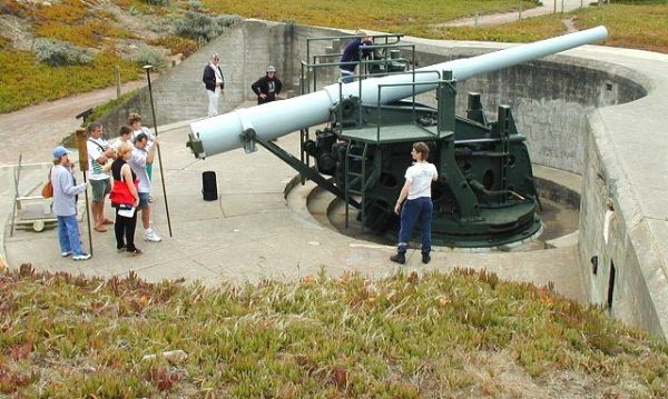
The beach has a military spine. The Presidio was a working Army post from 1776 until 1994, and the proof is set into the bluff above the sand: Battery Chamberlin, completed in 1904, with four 6-inch guns on disappearing carriages built to cover the minefields outside the Golden Gate. Its guns were pulled in 1948; the one disappearing gun mounted there now is a 1977 Smithsonian gift, which the National Park Service runs up and down for visitors on the first weekend of most months.

The northern end, below the steep bluff and reached by the wooden Sand Ladder, is clothing-optional and has been for decades — the quieter, more exposed half, with the cleanest bridge view and the worst current. The water is cold all year (no sea-surface temperature is on record for the beach; the open Pacific outside the Gate runs in the low 50s Fahrenheit), and the riptides are strong enough that the Presidio's guidance is blunt: be extremely cautious, the currents can overpower experienced swimmers. There are no lifeguards. People do not swim here. They wade, photograph, and leave.

That is the honest shape of Baker Beach. In a photograph it is the warm California beach of the imagination — bridge, surf, golden sand. In person it is usually grey, often fogged in by the marine layer that pours through the Gate on summer afternoons, wind-blown, and fronted by water that will kill a confident swimmer. People come for the view and the history, not the swim, and the place rewards them exactly that far.

The spike

Burning Man began here: an 8-foot wooden Man burned at Baker Beach on the June 1986 solstice, four years before it left for the Nevada desert.

Baker Beach has two claims to fame and they point in opposite directions. The obvious one is geographic: it is the best ground-level vantage on the Golden Gate Bridge that you can reach by car and walk onto barefoot. The other one is cultural, almost accidental, and far stranger: this is where Burning Man was born.

The origin is well documented and worth getting exactly right rather than mythologizing. On the summer solstice in June 1986, Larry Harvey and his friend Jerry James built an eight-foot human figure out of scrap lumber, carried it down to the north end of Baker Beach, and burned it in front of roughly twenty people. Accounts of Harvey's motivation vary — he gave more than one version over the years — but the act itself is not in dispute. What is striking is what happened next: passers-by on the beach were pulled toward the fire, and the crowd that night grew beyond the friends who had planned it. So they did it again the next solstice, and the next. The figure got taller. The crowd kept doubling. By 1990 the gathering had grown large enough that the Golden Gate National Recreation Area rangers stopped the burn — the group had no fire permit — and the event relocated to the Black Rock Desert in Nevada, where it became the festival the world now knows. The exact June day of that first 1986 burn is reported inconsistently across sources (some say the 21st, some the 22nd); what is consistent and verifiable is the year, the solstice, the eight-foot figure, the two men, the roughly twenty witnesses, and the 1986-to-1990 run before the move. Everything that Burning Man became — the desert, the 70,000 people, the ten principles, the Man as a standardized timber colossus — grew from a small driftwood-fed beach bonfire here.

Why this beach, specifically? Two practical reasons. Baker Beach collects driftwood, which is fuel. And it was, in the mid-1980s, a semi-wild edge of the city inside a still-active military reservation — the Presidio was a working U.S. Army post until 1994 — which made it the kind of place where a small group could light a fire at the waterline on a solstice night without much official attention. That second condition is exactly what failed by 1990, once the crowd outgrew the obscurity.

The military character is not background; it is built into the bluff. Battery Chamberlin, completed in 1904 above the south end of the beach, is the most intact reminder. It mounted four 6-inch rifled guns on 'disappearing' carriages — a clever Endicott-era design in which the recoil of firing drops the barrel back down behind the concrete parapet, where the crew can reload it out of an enemy's line of sight, before it is hoisted back up to fire again. The battery's job was to defend the minefields the Army laid in the channel outside the Golden Gate. Its guns came out in 1948 after the Second World War made coastal artillery obsolete; the single 6-inch disappearing gun installed there today is not original to the site but a 1977 donation from the Smithsonian, and the Park Service demonstrates it monthly. You can stand at the gun, look out at the water it was built to deny an enemy, and see the bridge that was finished in 1937, decades after the battery was already watching that same stretch of sea.

The bridge view is the third leg, and it is genuinely exceptional — but it is worth being precise about why. Most famous Golden Gate vantage points (Fort Point, the Marin Headlands, the bridge walkway itself) put you above or beside the structure. Baker Beach puts you at sea level, south of the span, looking north across the mouth of the strait so that the bridge, the breaking surf, and the Marin hills stack into one composition. That sea-level angle is the specific thing photographers come for, and it is the same exposed Pacific aspect that makes the water dangerous: the beach faces straight into open-ocean swell with nothing — no reef, no breakwater, no sheltering headland — between the sand and the North Pacific.

Which brings the two claims back into a single point. The conditions that make Baker Beach beautiful are the conditions that make it cold and unsafe. Its open western exposure delivers the dramatic surf and the unobstructed bridge frame; it also delivers water in the low 50s Fahrenheit year-round, riptides strong enough to drag experienced swimmers, and the marine-layer fog that boils through the Gate on summer afternoons and erases the very view people drove out to see. There are no lifeguards. The northern, clothing-optional end has the best sightline and the worst current. The Presidio's own advice is to be extremely cautious in the water; the realistic advice is not to get in it. Baker Beach is a place to look, to walk, and to stand where a beach bonfire turned into a global festival — not a place to swim.

BakeBeachAtMidday.jpg
Culture

Where it shows up

History
  • The first Burning Man · 1986
    Larry Harvey and Jerry James

    The single most consequential thing to happen on this beach. On the June 1986 solstice, Harvey and James burned an eight-foot wooden 'Man' at the north end before about twenty people. The annual burn grew here until 1990, when it moved to Nevada's Black Rock Desert and became the festival now attended by tens of thousands. Baker Beach is the literal origin point.

Film
  • A View to a Kill · 1985
    John Glen (director); EON Productions

    The 1985 James Bond film built its climax around the Golden Gate Bridge and San Francisco, putting the same bridge-and-strait scenery that frames Baker Beach into the global pop-culture image of the city. A representative example of how thoroughly this stretch of coast is bound to the bridge's on-screen identity.

Other
  • Battery Chamberlin disappearing-gun demonstrations · 1977
    National Park Service

    A living-history fixture: the NPS regularly raises and lowers the 6-inch disappearing gun (the 1977 Smithsonian donation) at Battery Chamberlin and opens the underground cartridge room, letting visitors see a piece of pre-WWI coastal-defense engineering in operation above the beach.

Seacliff District SF.jpg
History

What happened here

  1. 1776history

    The Presidio is founded as a Spanish garrison

    Spain establishes the Presidio of San Francisco as a military fort guarding the entrance to San Francisco Bay. The land that includes Baker Beach will remain a working military reservation — Spanish, then Mexican, then U.S. Army — for the next 218 years.

    Wikipedia →
  2. 1904built

    Battery Chamberlin completed

    The U.S. Army completes Battery Chamberlin on the bluff above the south end of Baker Beach, mounting four 6-inch rifled guns on disappearing carriages to defend the minefields outside the Golden Gate. It is named for Civil War officer Captain Lowell A. Chamberlin.

    Wikipedia →
  3. 1937built

    The Golden Gate Bridge opens

    The Golden Gate Bridge opens across the strait just north of Baker Beach, giving the beach the sea-level vantage on the span that becomes its defining attraction. The bridge tower nearest the beach rises directly off its northern end.

    Wikipedia →
  4. 1948history

    Battery Chamberlin's guns removed

    After the Second World War renders fixed coastal artillery obsolete, the Army removes the guns from Battery Chamberlin. The battery's concrete emplacements remain in the bluff above the beach.

    Wikipedia →
  5. 1959tragedy

    Fatal shark attack: Albert Kogler Jr.

    On 7 May 1959, 18-year-old Albert Kogler Jr. is killed by a shark while swimming off Baker Beach in about 15 feet of water — one of the very few documented fatal shark attacks within San Francisco itself.

    Wikipedia →
  6. 1977history

    Smithsonian donates a 6-inch disappearing gun

    The Smithsonian Institution donates a 6-inch disappearing gun to the National Park Service, which installs it at Battery Chamberlin so the disappearing-carriage mechanism can be demonstrated to the public. It is not original to the site.

  7. 1986cultural

    The first Burning Man

    On the June 1986 summer solstice, Larry Harvey and Jerry James burn an eight-foot wooden figure — 'the Man' — at the north end of Baker Beach before about twenty people. The exact day in June is reported inconsistently; the year, the solstice, the figure, and the two builders are well attested.

    Wikipedia →
  8. 1990cultural

    Burning Man leaves Baker Beach for Nevada

    After four years of growing solstice burns, GGNRA rangers stop the 1990 burn for lack of a fire permit. The event relocates to the Black Rock Desert in Nevada, where it becomes the international festival it is today.

    Wikipedia →
  9. 1994policy

    The Presidio becomes a national park site

    On 1 October 1994, after 219 years of military use, the U.S. Army transfers the Presidio — including Baker Beach — to the National Park Service within the Golden Gate National Recreation Area. A 1972 law had set this transfer in motion if the Army ever left.

    Wikipedia →
The honest part
The open Pacific exposure that frames the bridge and breaks the surf is the same exposure that keeps the water in the low 50s, drives riptides that overpower strong swimmers, and lets the fog erase the view you drove out to see.

The photographs lie by omission. Baker Beach in a picture is the warm, golden California beach under the Golden Gate Bridge; Baker Beach in person is usually grey, wind-blown, and fronted by water that runs in the low 50s Fahrenheit and carries riptides the Presidio openly warns can overpower experienced swimmers. There are no lifeguards. People drown on this coast — the open Pacific outside the Golden Gate is one of the more lethal swimming environments adjacent to any U.S. city, and the official answer here is simply not to swim. The danger is not only the cold and the current. On 7 May 1959, 18-year-old Albert Kogler Jr. was killed by a shark while swimming off Baker Beach in about 15 feet of water — one of the few documented fatal shark attacks inside San Francisco itself (note: this contradicts the zero-incident figure in some beach datasets, and the dataset is the one that is wrong).

The other costs are gentler but real. The marine layer that pours through the Gate on summer afternoons routinely erases the bridge view that is the entire reason most visitors come, so the postcard and the actual visit frequently do not match. The two free parking lots fill by mid-morning on clear weekends, and the beach — only about 800 metres long — concentrates the whole region's appetite for that one bridge sightline onto a narrow strip of sand. None of this makes it a bad place. It makes it a place that is honest only if you describe the cold, the current, the fog, and the gap between the picture and the day.

6in Rifled Gun No 9.jpg
Anatomy

The shape of the place

South end below Battery Chamberlin

15%

The southern end nearest the main parking lots and the trail up to Battery Chamberlin's 1904 gun emplacements. The calmer, more family-oriented end, set back from the worst of the current.

Best for Easiest access, visiting Battery Chamberlin, families with young children

Battery Chamberlin's disappearing-gun demonstrations are run by the NPS on the first weekend of most months; check the Presidio schedule.

Central sand

50%

The wide middle of the beach, the most general-use stretch — picnics, dog-walking, sunbathing on the rare warm day, and the largest open view of bridge, surf, and Marin Headlands stacked together.

Best for Picnics, families, the stacked bridge-and-surf photograph

No lifeguards anywhere on the beach. People wade; almost no one swims. Restrooms and picnic tables are the only facilities.

North Baker Beach (clothing-optional) and the Sand Ladder

85%

The northern half below the steep bluff, closest to the Golden Gate Bridge and the cleanest sightline on it. Long-established clothing-optional beach; the wooden Sand Ladder climbs from here to the Batteries to Bluffs and California Coastal trails. This is also where the burns of 1986–1990 happened.

Best for The best bridge view, naturism, walking up to the bluff trails, the Burning Man site

The current is strongest at this end and the water is cold and unguarded. Watch rising tides if you scramble over the rocks at the far north.

Landmarks

Golden Gate Bridge · 1937

built · Joseph Strauss (chief engineer), Charles Ellis, Irving Morrow

The 1937 suspension bridge across the mouth of San Francisco Bay, whose south tower rises directly off the north end of Baker Beach. The sea-level, south-of-the-span view from the sand — bridge, breaking surf, and Marin Headlands in one frame — is the beach's defining attraction.

Wikipedia →

Battery Chamberlin · 1904

heritage · U.S. Army Corps of Engineers (Endicott program)

Coastal-defense battery on the bluff above the south end of the beach, completed 1904 with four 6-inch guns on disappearing carriages and named for Captain Lowell A. Chamberlin. Its guns were removed in 1948; the single 6-inch disappearing gun shown today is a 1977 Smithsonian donation, demonstrated monthly by the National Park Service, with an underground cartridge room of coastal-defense exhibits.

Wikipedia →

The Sand Ladder

route

A wooden-stepped sand staircase climbing the bluff from the north end of Baker Beach up to the Batteries to Bluffs Trail and the California Coastal Trail. The link between the beach and the clifftop Presidio trail network, and a steep workout back up.

A day here

From first light to dark

Dawn

Early, before the fog has decided what to do, the beach belongs to dog-walkers, a handful of photographers waiting for the bridge to clear, and the occasional cold-water swimmer in a wetsuit who knows the risk. The light, when there is light, comes from behind the city and lands on the bridge's south tower; the water is at its calmest, which on this coast still means open ocean with a riptide and no one watching it.

Midday

By late morning on a clear day both free lots are full and the half-mile of sand carries the day's full crowd — families at the south end near Battery Chamberlin, sunbathers and naturists up the north end below the bluff. People wade to their knees and retreat; almost no one swims. On a fogged-in day, which is common in June and July, the bridge simply isn't there, and the beach is grey, wind-raked, and half-empty by noon.

Golden hour

Late afternoon is the photographers' hour and the reason the beach is famous. If the marine layer has burned back, the low sun lights the bridge from the southwest and the surf breaks gold in front of it. This is the picture. The north end, clothing-optional and quieter, has the cleanest line on the span. The wind usually picks up as the sun drops, and the temperature falls faster than first-time visitors expect.

Night

After dark Baker Beach is unlit and effectively closed — no lifeguards, no commerce on the sand, the parking lots emptying. For five solstice nights between 1986 and 1990 this north end was the brightest thing on the coast, a burning figure pulling strangers out of the dark; now the dark is just dark, with the bridge lights to the north and container ships standing off the Gate. It is not a beach to be in the water at night, and barely one to be on it.

Compare

How it ranks

Peak warmth
Cooler than 91% of beaches in its country
Peak-month high ≈ 22°C
Beach season
Longer beach season than 66% of beaches in its country
7 comfortable months a year

Ranked against every beach in our database — 228,000+ worldwide.

Baker Beach path with shrubs and crow.jpg
Sea & surf

What the water does

JFMAMJJASONDmetres (significant wave height)

Solid = typical monthly wave height; pale = the bigger days (90th pct). Offshore/regional swell from Open-Meteo Marine (ERA5 Ocean reanalysis, 2023–2024); a sheltered cove may sit calmer than this.

Exposed — real surf, and rip current to respect
Typical wave height
1.45 m
Biggest swell
Jan · 2.14 m
Calmest
Aug · 0.94 m
Typical period
10.5 s (groundswell)
Before you go

Things to know

Do not swim — cold water, riptides, no lifeguards

The water is cold all year and the riptides can overpower even strong swimmers; the Presidio's own guidance is to be extremely cautious, and there are no lifeguards. There is a documented 1959 shark fatality here as well. Realistically, this is a wading-and-walking beach, not a swimming one.

Expect fog, especially in summer

The bridge view that draws you here is frequently erased by the marine layer on June–August afternoons. For the clearest skies and warmest days, come in September or October. Bring layers regardless — it is windier and 10–15°F cooler than downtown.

The north end is clothing-optional

The northern section, below the bluff and up the Sand Ladder, is a long-standing clothing-optional beach. It also has the best bridge sightline and the strongest current. Plan accordingly if visiting with children, and keep to the south/central sand if you prefer.

Two free lots, no food, restrooms only

Parking is free in two lots but fills by mid-morning on clear weekends; overflow is along Lincoln Boulevard. The beach has restrooms and picnic tables but no food or drink — pack a picnic. Fires are not permitted (the reason Burning Man eventually had to leave).

Surf & rip

Powerful water — strongest around Jan, gentlest in Aug. Mind rip currents; this isn't a wade-in-anywhere beach.

Sharks

No incidents on record in the global shark-attack file.

Plan

If you go

Getting there
Nearest airport
San Francisco International Airport (SFO) · 22 km
Nearest town
Sausalito · 7 km

Baker Beach is in the Presidio on San Francisco's northwest shore, inside the Golden Gate National Recreation Area, about 21.6 km from San Francisco International Airport (SFO). By car, take US-101 to Lincoln Boulevard and follow signs through the Presidio to the Baker Beach lots; from Marin, cross the Golden Gate Bridge and exit to Lincoln Boulevard. There are two free parking lots — they fill by mid-morning on clear weekends, with overflow along Lincoln Boulevard a short walk away. By transit, Muni serves the Presidio (routes shift; check SFMTA), and the beach is a walkable couple of miles from the Presidio main post and visitor center. The Sand Ladder at the north end connects up to the Batteries to Bluffs and California Coastal trails. Facilities are limited to restrooms and picnic tables; there is no food on the beach, and there are no lifeguards.

When to go
  • Battery Chamberlin first-weekend gun demonstrations · First weekend of most months (check the Presidio/NPS schedule)

    The National Park Service demonstrates the 6-inch disappearing gun and opens the battery's underground rooms to visitors. The main scheduled draw at the beach, free and run by NPS staff and volunteers.

  • Summer fog season · Roughly June to August

    Not an event but a reliable condition: the marine layer pushes through the Golden Gate on summer afternoons and frequently buries the bridge view. The clearest, warmest beach weather in San Francisco usually comes later, in September and October.

What to eat & drink
Nothing on the sand — pack in

There is no food or drink concession on Baker Beach itself; the facilities are restrooms and picnic tables, nothing more. The standard move is to bring a picnic. Alcohol rules within the GGNRA/Presidio are restrictive and fires are not permitted, so this is a pack-in, pack-out beach, not a beach-bar one.

Baker Beach (restrooms and picnic tables only)

Cioppino

San Francisco's own seafood stew — Dungeness crab, clams, mussels, fish, and shrimp in a tomato-wine broth — invented by the city's Italian fishing community in the late 1800s. It is the most San Francisco thing you can eat after a cold afternoon on this coast. Found across the city; closest concentrations are toward the Marina, the Wharf, and North Beach.

Restaurants across San Francisco (Fisherman's Wharf, North Beach, the Marina)

Dungeness crab

The local crab, in season roughly November through June, sold cracked and cold or steamed whole. It is the regional shellfish that cioppino was built around and the thing to look for in winter, the same months the beach's surf runs biggest.

Fisherman's Wharf and seafood markets across the city

Coffee and a sourdough stop in the Presidio / Marina

The nearest real eating-and-drinking is back inland — the Presidio's main post and the Marina District a short drive east. San Francisco sourdough (a genuinely local fermentation, tied to the city's specific wild-yeast strain) and coffee are the practical pre- or post-beach stops, since the beach has none.

Presidio main post; Marina District (a few minutes' drive east)

Sources & references
  1. NPS / Presidio.gov: Battery Chamberlin; Wikipedia: Battery Chamberlin · cited 2×
  2. Wikipedia: Baker Beach · cited 2×
  3. Presidio.gov: Then + Now: Burning Man at Baker Beach; Burning Man Project timeline · cited 2×
  4. NPS: Presidio of San Francisco; Wikipedia: Presidio of San Francisco
  5. Wikipedia: Golden Gate Bridge
  6. NPS / Presidio.gov: Battery Chamberlin; CBS News
  7. NPS / Presidio.gov: Battery Chamberlin
  8. NPS: Presidio of San Francisco; Presidio.gov press release
  9. Wikipedia: Baker Beach; Presidio.gov: Baker Beach
  10. Presidio.gov: Then + Now: Burning Man at Baker Beach; Burning Man Project timeline; Wikipedia: Baker Beach
  11. Presidio.gov: Baker Beach; California Beaches: North Baker Beach
  12. Presidio.gov: Baker Beach; California Beaches: North Baker Beach; Wikipedia: Baker Beach
  13. NPS: Presidio of San Francisco; Presidio.gov press release (25 years as a national park site)
  14. Wikipedia: Baker Beach; Open-Meteo Marine (ERA5 reanalysis, 2023–2024)
Colophon · Provenance

Where this page comes from

Geography, facilities
OpenStreetMap (ODbL) for geometry and facility tags within 500 m of the beach centroid. GeoNames for city/airport distances.
Climate & ocean
worldclim_v2.1_2.5m
Tides
eot20
Photography
Archival, original tone (Tier B — Wikimedia Commons). Each image licensed per its own terms; attribution visible inline.
History & culture
Every factual claim is linked to its source in the prose above. Wikipedia citations inline. Non-wiki sources named where relevant.
Editorial voice
Register: technical. Written to pass a local's nod test; corrections welcome.
Written by Erin Rose
Last reviewed 2026-04-19
v0.9in editorial development toward v1.0