Chon Buri, TH

Bang Saen

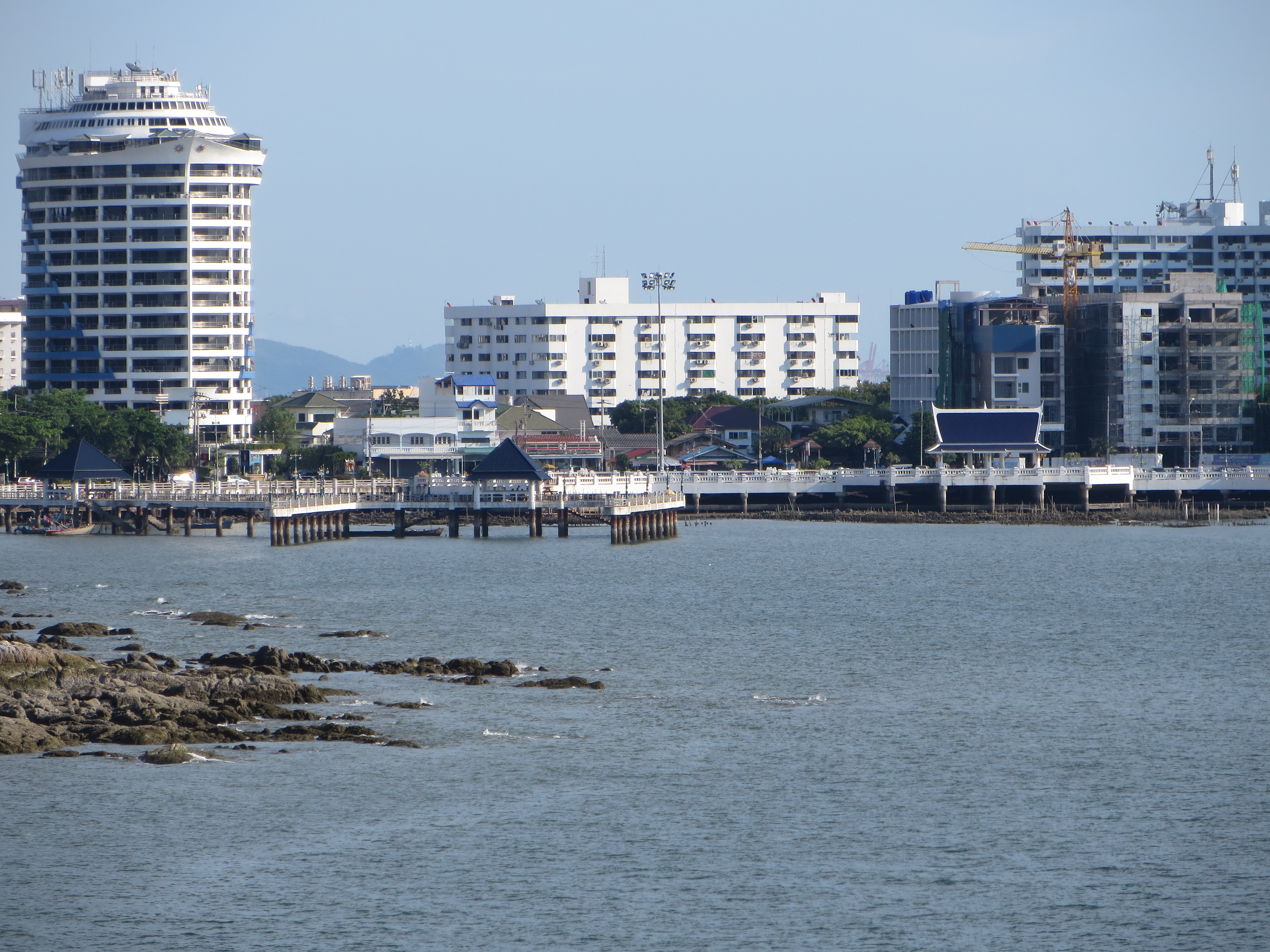
Bang Saen 01.JPG

Chon Buri, TH

Bang Saen Beach

In June 2026, several Bryde's whales — part of a pod surveyed at about 13 — fed within 2 km of Bang Saen as a rescue official warned of nighttime boats.

Bang Saen 01.JPG · <a href="//commons.wikimedia.org/wiki/User:Mstp77" title="User:Mstp77">atreyu</a> · CC BY-SA 3.0
Nearest airport
BKK · 50 km
I’m here for
Story

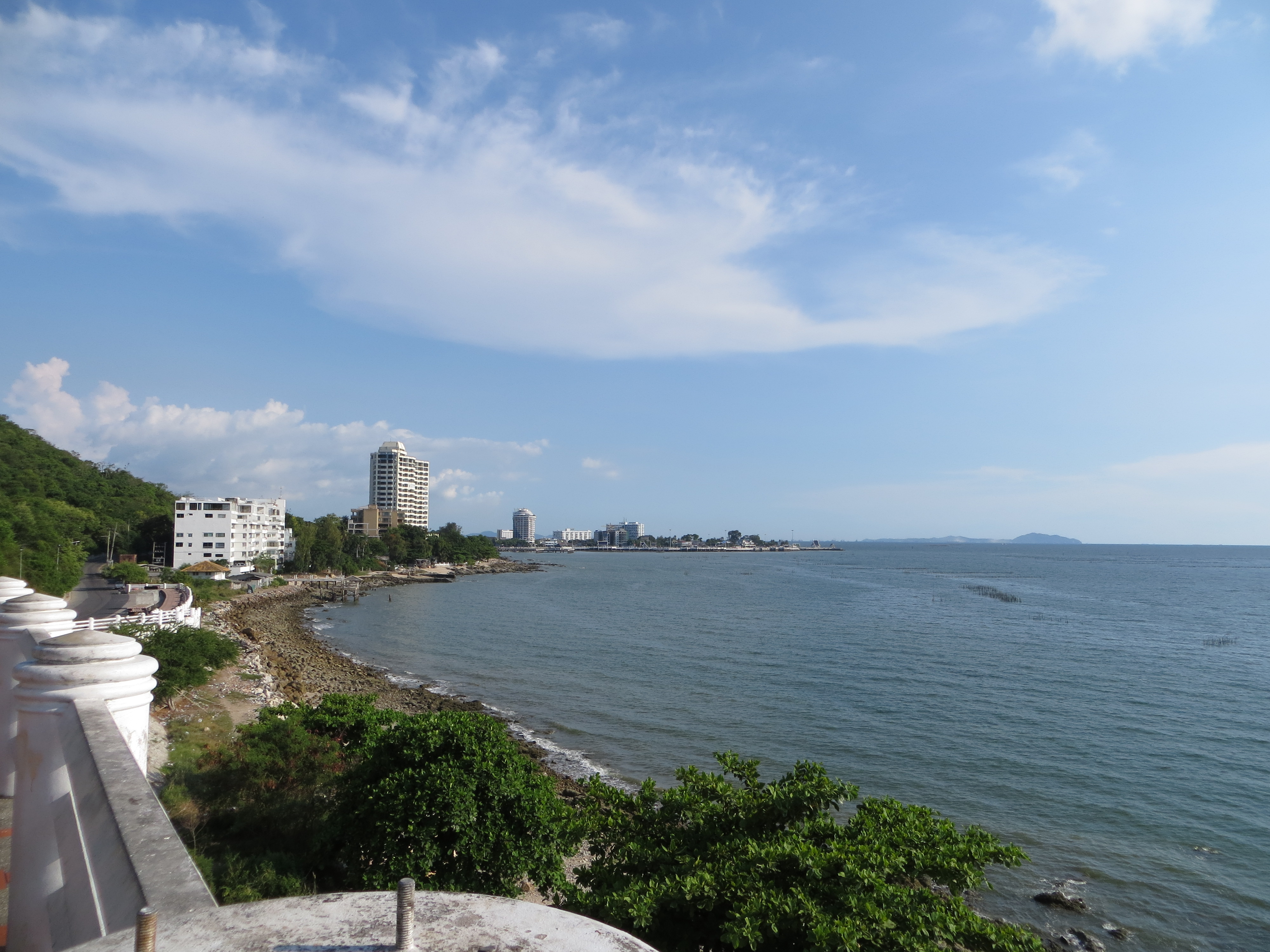
Bang Saen Beach is a Thai-domestic weekend beach on the Gulf of Thailand in Tambon Saen Suk, Mueang Chonburi district — about 108 km southeast of Bangkok, next to Ang Sila and north of Pattaya. It is not an international resort strip. Locals also call it Bangsaen or Hat Bang Saen (หาดบางแสน), and it has long carried a nickname: "the land for lonely souls."

How long the beach is depends on the source. English Wikipedia gives about 2.5 km, maintained by Saen Suk town municipality. Thai Wikipedia describes a continuous 4.5 km shoreline in three sections: central Bang Saen, the swimming area; Laem Thaen to the north, rocky and unswimmable; and Wan Napa to the south, a quiet fishing-village stretch. The 2.5 km figure likely covers only the central section.

The water here has had an eventful two years. On November 7, 2025, the shoreline turned visibly black; the report attributed it to a storm-triggered plankton bloom and Bang Pakong River runoff, vendors reported no dead fish or smell, and it was expected to clear — no water-quality data was cited. On May 15, 2026, rescuers pulled a stray Irrawaddy dolphin calf, the first ever recorded here, from the surf; it died despite care at Burapha University's marine institute. On June 26, 2026, boaters documented several Bryde's whales — part of a group of about 13 surveyed this year, some identifiable by scars and barnacles — feeding within 2 km of shore, even as a marine rescue official warns nighttime fishing-boat traffic threatens a species that sleeps with only half its brain at a time.

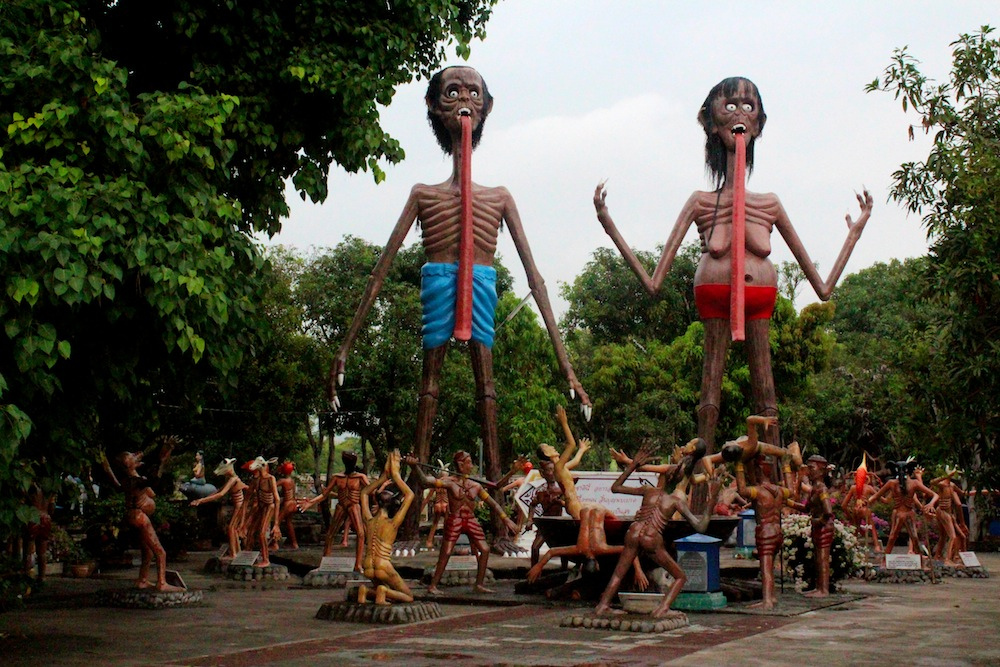
The name comes from a folk tale about two Chonburi lovers, Saen and Sam Muk, who drowned themselves after their families forbade the match — the story also named the headland Khao Sam Muk. The beach became a popular destination from 1943, per Thai Wikipedia. A short way inland, Wang Saen Suk holds Thailand's largest hell garden — twenty-one tortured souls built to frighten visitors into virtue. Since 2007, an FIA Grade-3 circuit has closed the coast road for the Bangsaen Grand Prix, in recent years around the turn of June and July.

Suvarnabhumi Airport (BKK) is 50.3 km away in a straight line; no sourced road driving time exists for that route. The nearest city, Si Racha, is 10.3 km south. Most visitors use Motorway 7, Thailand's first intercity motorway — 149.3 km total, a 120 km/h limit, nine tollgates — where a standard car pays 25 THB at the Lat Krabang gate near Bangkok and 105 THB at the Pattaya gate.

The spike

In June 2026, several Bryde's whales — part of a pod surveyed at about 13 — fed within 2 km of Bang Saen as a rescue official warned of nighttime boats.

Bang Saen's newest reason to matter isn't the sand. It's what showed up 2 km off it. On June 26, 2026, tourists and boaters documented several Bryde's whales — including calves — swimming and feeding in Saen Suk Subdistrict's waters; this year's survey found about 13, more than the year before. The largest individual, per the report, is the size of a city bus and weighs over a ton. Researchers identify the animals one by one, by scars, spot patterns, and barnacle growth, and they track two distinct groupings: one near Koh Sampanyue north of Koh Si Chang, another closer to shore near Khao Sam Muk and Ang Sila, the headland and fishing town that bracket Bang Saen itself.

A real comeback, in a working lane. Bryde's whales are baleen whales that feed by lunging through schools of small fish, and a pod this size persisting this close to a municipal beach is not routine — it reads as a genuine recovery story for the upper Gulf of Thailand, a body of water more associated with cargo traffic and fishing fleets than megafauna. But the same waters that feed the whales are worked at night by pair trawlers and commercial fishing boats, and Eksak Soemsri, the marine rescue official and boat owner who runs the whale survey, has flagged that traffic as a real risk to the pod. The reason is physiological, not incidental: Bryde's whales rest with only half their brain asleep at a time, alternating hemispheres so they can keep swimming and surfacing to breathe. That adaptation lets them sleep on the move. It does not let them see a boat coming.

The pattern repeats with smaller animals. Six weeks before the whale pod was documented, on May 15, 2026, Saen Suk's White Shark Marine Life Rescue Team, led by Natdanai Mongkunkong, pulled a baby Irrawaddy dolphin — about 1.20 meters long — out of the surf at Bang Saen Beach. It was the first time a stray Irrawaddy dolphin calf had ever been recorded straying into these waters. The rescue team moved it to Burapha University's Institute of Marine Science, the same research institute that studies the whale pod, for round-the-clock veterinary care. The calf died anyway. Rescuers believe strong waves and wind separated the calf from its group — a reminder that the water off a beach marketed as calm is not always calm.

And the water itself is not a constant. Six months before the dolphin died, on November 7, 2025, Bang Saen's shoreline water turned visibly black. A 70-year-old beach vendor, Sirikanya Triudom, described the shift in real time: crystal clear two weeks earlier when the cool season started, then rain and freshwater from the Bang Pakong River mixing with the seawater until it looked, in her words, like this. The report also attributed the color to a storm-triggered plankton bloom. A 30-year-old food vendor, Phuridech Singsat, offered the reassurance that stood in for water-quality data: no dead fish, no strong smell, so it's not dangerous, just odd-looking. Nobody in the reporting cited a dissolved-oxygen reading or a bacterial count. The vendors' read on the water was the only read on the water.

None of this means Bang Saen is unsafe. Nothing in the record says it is. What the record shows is a beach whose marketing rests on calm, sheltered, family-friendly water — and whose most notable recent events are a pollution scare nobody measured, a marine mammal death nobody could prevent, and a wildlife spectacle that the rescue official who surveys the pod is warning could end the same way the dolphin did. The whales are the good version of the same story the dolphin is the bad version of: this stretch of the Gulf is more alive, and more used, than its postcard image suggests, and the animals moving through it — like the swimmers on the sand — are relying on a system of nighttime boat traffic and storm runoff that nobody is formally tracking on their behalf.

Why it's the spike and not a footnote. A quiet fact sheet could have led with the whale sighting alone and called it wonder. It's the layering that makes Bang Saen's water the real story: a beach that promotes itself on safety hosted, within seven months, an unexplained color change, a dead calf, and a thriving-but-threatened pod, and the public account of all three came from vendors and researchers reacting after the fact rather than from any standing monitoring program. That's not a condemnation of the beach. It's a description of what "safe swimming water" actually means here: mostly true, occasionally interrupted, and checked by whoever happens to be standing on the sand when it changes.

Bang saen lang beach.jpg
Culture

Where it shows up

History
  • The legend of Saen and Sam Muk

    A folk tale of two unrequited Chonburi lovers who drowned themselves together after their families forbade the match; the story gave Bang Saen its name and also named the headland Khao Sam Muk.

  • Sam Muk's shrine legend at Khao Sam Muk

    Local legend holds that a poor Chinese girl named Sam Muk jumped to her death from the cliff after her parents objected to her marriage; she was later deified, and locals believe her spirit protects fishers from harm.

Other
  • "The land for lonely souls"

    A local nickname for Bang Saen, carried since it became a popular destination, per Thai Wikipedia.

  • Mazu shrine at Khao Sam Muk summit

    A Chinese shrine to the sea goddess Mazu sits at the hill's summit, distinct from the Thai shrine tied to the local legend at its base.

Fiat 131 Abarth, Bangsaen Speed Festival 2007.jpg
History

What happened here

  1. 1943history

    Bang Saen becomes a popular destination

    Thai Wikipedia dates Bang Saen's rise as a popular tourist destination to 1943 (B.E. 2486).

  2. 1955institution

    Burapha University founded as Bangsaen College of Education

    Thailand's first regional tertiary institute opens on July 8, 1955, adjoining Bang Saen; it now enrolls 47,865 students.

    Wikipedia →
  3. 2007sports

    Bangsaen Street Circuit opens

    A 3.740 km, 19-turn, FIA Grade 3 asphalt street circuit opens on Bang Saen's coastal roads.

    Wikipedia →
  4. 2017sports

    Circuit begins hosting international racing

    After redevelopment by Apex Circuit Design, the circuit starts hosting Porsche Carrera Cup Asia (2017-2019, returning 2024) and TCR Asia (2017-2019).

    Wikipedia →
  5. 2025festival

    Sand Pagoda Festival features 'Whale of Freedom' sculpture

    The Tourism Authority of Thailand's Pattaya office enters a sand sculpture titled 'Whale of Freedom' in the 2025 Wan Lai sand-pagoda festival.

  6. 2025pollution

    Water turns visibly black near shore

    On November 7, 2025, Bang Saen's shoreline water turns black; the report attributes it to a storm-triggered plankton bloom and Bang Pakong River runoff after storms, and vendors report no dead fish or odor.

  7. 2026wildlife

    Stray Irrawaddy dolphin calf rescued and dies

    On May 15, 2026, Saen Suk's White Shark Marine Life Rescue Team pulls a 1.20-meter Irrawaddy dolphin calf — the first ever recorded at Bang Saen — from the surf; it dies despite treatment at Burapha University's marine institute.

  8. 2026wildlife

    Bryde's whale pod documented feeding offshore; 2026 survey counts about 13

    On June 26, 2026, tourists and boaters document several Bryde's whales, including calves, feeding roughly 2 km offshore in Saen Suk Subdistrict; this year's survey has identified about 13 whales in Bang Saen waters, more than the year before.

  9. 2026sports

    Bangsaen Grand Prix marks the event's 20th anniversary

    The Bangsaen Grand Prix 2026 runs July 1-5 with more than 100 cars expected and free public entry, marking what organisers billed as the event's 20th anniversary.

    Wikipedia →
The honest part
“The reassurance about the black water came from a 30-year-old food vendor, not a water sample.”

Bang Saen sells itself, implicitly, on calm water: a sheltered Gulf beach where Bangkok weekenders can swim without the surf or crowds of Thailand's more exposed coasts. The record doesn't contradict that so much as complicate it. In a seven-month stretch from November 2025 to June 2026, the same water turned visibly black after a storm (explained only by vendors, not measured), stranded and killed a dolphin calf that had never been recorded there before, and hosted a genuine wildlife comeback — a pod of Bryde's whales — that a marine rescue official says is itself endangered by the boat traffic sharing the water. No official source confirms lifeguard staffing, rip-current risk, or a formal closure protocol for any of it.

The beach's basic facts aren't even settled. English and Thai Wikipedia disagree on whether Bang Saen is 2.5 km or 4.5 km long, and the only specific, currently-operating food business associated with it — "Seafood Club Bang Saen" — appears solely in aggregator listings nobody has independently verified. None of this makes Bang Saen dangerous or fake. It makes it a real, working municipal beach that Bangkok's tourism apparatus describes more confidently than its own available data supports.

Bang Saen Beach at sunset 2.jpg
Anatomy

The shape of the place

Laem Thaen

15%

The northern section of the continuous shoreline described by Thai Wikipedia: rocky, and explicitly not for swimming.

Best for Views toward Khao Sam Muk

No swimming, per Thai Wikipedia.

Central Bang Saen

50%

The central, swimmable section of the shoreline — what most visitors mean by "Bang Saen Beach" and the section English Wikipedia's 2.5 km figure most likely describes.

Best for Swimming and the main beachfront restaurants and beach-chair rentals

Wan Napa

85%

The southern section of the continuous shoreline: a quieter stretch with a small fishing village, per Thai Wikipedia.

Best for A quieter alternative to the central beachfront

Landmarks

Khao Sam Muk

headland

A sandstone hill between Ang Sila and Bang Saen Beach, given as 54 m in Wikipedia's infobox but 45 m in the article's own text — an unresolved discrepancy in the source itself. Its summit holds a Chinese shrine to the sea goddess Mazu; a second, Thai-built shrine sits at the escarpment's foot, tied to the local drowning legend.

Wikipedia →

Wang Saen Suk

temple

A Buddhist temple near Bang Saen Beach housing the largest hell garden in Thailand: twenty-one tortured souls with animal heads, plus two giant Preta figures, built to depict Naraka (Buddhist hell) and warn visitors away from sin.

Wikipedia →

Bangsaen Street Circuit · 2007

racetrack

A 3.740 km, 19-turn, FIA Grade 3 asphalt street circuit built into Bang Saen's coastal roads, which has hosted Porsche Carrera Cup Asia (2017-2019 and since 2024) and, from 2017 to 2019, TCR Asia.

Wikipedia →
A day here

From first light to dark

Dawn

English Wikipedia says the sea here is usually not clear except from October to February, when it likens the water to the Maldives — a description, not a measurement; site wave data puts the calmest average month, October, at just 0.14 m.

Midday

Midday brings Bangkok weekenders to the beachfront seafood restaurants and rented beach chairs that make up Wikipedia's only description of Bang Saen's food scene — no specific dish or vendor is named or sourced beyond that.

Golden hour

Even in its roughest month the water stays modest: Open-Meteo's reanalysis puts April's average at 0.55 m (big days around 0.74 m) and October's at 0.14 m, so the light at day's end plays out over flat water, not surf.

Night

After dark, the beach's water hosts a different risk than swimmers face: a marine rescue official says nighttime fishing-boat traffic threatens the Bryde's whale pod feeding within 2 km of shore, because the whales sleep with only half their brain at a time.

Bang Saen 04.JPG
Sea & surf

What the water does

JFMAMJJASONDmetres (significant wave height)

Solid = typical monthly wave height; pale = the bigger days (90th pct). Offshore/regional swell from Open-Meteo Marine (ERA5 Ocean reanalysis, 2023–2024); a sheltered cove may sit calmer than this.

Calm — gentle swimming water most of the year
Typical wave height
0.37 m
Biggest swell
Apr · 0.55 m
Calmest
Oct · 0.14 m
Typical period
3.2 s (wind chop)
Before you go

Things to know

Beach length is disputed

English Wikipedia gives 2.5 km; Thai Wikipedia describes a continuous 4.5 km shoreline in three sections, of which the swimmable central section is likely what the 2.5 km figure describes.

No sourced lifeguard or rip-current data

No official source or dated press report confirms lifeguard staffing, rip-current risk, or formal beach-closure protocols specific to Bang Saen.

Water can turn visibly dark after storms

On November 7, 2025, the water near shore turned black; the report attributed it to a storm-triggered plankton bloom and Bang Pakong River runoff mixing with seawater, and vendors reported no dead fish or odor, but no water-quality data was cited.

Jellyfish signage is unconfirmed

A claim that Bang Saen has posted jellyfish warning signs could not be corroborated by a Bang Saen-specific source; only generic Thailand-wide box-jellyfish guidance exists.

Swimming

Usually calm water — among the gentler beaches for a swim.

Sharks

No incidents on record in the global shark-attack file.

Plan

If you go

Getting there
Nearest airport
Suvarnabhumi Airport (BKK) · 50 km
Nearest town
Si Racha · 10 km

Bang Saen sits in Tambon Saen Suk, Mueang Chonburi district, about 108 km southeast of Bangkok and near Pattaya, to the south. Suvarnabhumi Airport (BKK) is 50.3 km away in a straight line; no sourced road driving-time or taxi-fare figure exists for that route. The sourced road corridor is Motorway 7, Thailand's first intercity motorway (149.3 km total, 125.865 km on the Bangkok-to-Pattaya section, 120 km/h limit, 9 tollgates), which runs through the area toward Chonburi and Pattaya; tolls for a standard car range from 25 THB at the Lat Krabang gate to 105 THB at the Pattaya gate, with higher rates for 6-wheel and over-6-wheel vehicles. The nearest city is Si Racha, 10.3 km away.

When to go
  • Bangsaen Grand Prix · Annually, in recent years around the turn of June and July; circuit opened 2007

    An FIA Grade 3 street race that closes Bang Saen's coastal roads; the 2026 edition ran July 1-5 with more than 100 cars expected and free public entry, marking what organisers billed as the event's 20th anniversary.

  • Wan Lai Sand Pagoda Festival · During the extended Songkran/Thai New Year season, April

    A sand-sculpture festival named by Saen Suk municipality as one of the town's defining traditions; the 2025 edition included the Tourism Authority of Thailand's Pattaya office entry, a sculpture titled 'Whale of Freedom.'

What to eat & drink
Beachfront seafood restaurants

Wikipedia's only description of Bang Saen's food scene: beachfront seafood restaurants alongside beach-chair rental facilities, with no specific dish, vendor, or business named or sourced beyond that.

Along the central Bang Saen beachfront, Saen Suk

Nong Mon Market

Saen Suk municipality's own website lists Nong Mon Market as one of the town's four defining attractions, alongside the beach itself, Khao Sam Muk, and the Wan Lai sand-pagoda tradition. A TourismThailand page describing dried squid and khao lam dessert there returned an access error on fetch, so no specific dish from the market is independently sourced here.

Saen Suk municipality, Chonburi

"Seafood Club Bang Saen"

This name appears only in aggregator travel-booking listings that were not independently fetched or verified; it is not confirmed here as a currently operating restaurant.

Unconfirmed

Sources & references
  1. Wikipedia: Bangsaen Street Circuit · cited 3×
  2. Thai Wikipedia: หาดบางแสน · cited 2×
  3. Wikipedia: Burapha University · cited 2×
  4. Thairath English, June 2026 · cited 2×
  5. The Pattaya News, July 2026 · cited 2×
  6. English Wikipedia: Bang Saen Beach · cited 2×
  7. Pattaya Mail, April 2025
  8. The Thaiger, November 2025
  9. The Pattaya News, May 2026
  10. Wikipedia: Wang Saen Suk
Colophon · Provenance

Where this page comes from

Geography, facilities
OpenStreetMap (ODbL) for geometry and facility tags within 500 m of the beach centroid. GeoNames for city/airport distances.
Climate & ocean
Open-Meteo ERA5 + Marine archive, 2014–2023 monthly normals.
Photography
Archival, original tone (Tier B — Wikimedia Commons). Each image licensed per its own terms; attribution visible inline.
History & culture
Every factual claim is linked to its source in the prose above. Wikipedia citations inline. Non-wiki sources named where relevant.
Editorial voice
Register: wry. Written to pass a local's nod test; corrections welcome.
Written by Erin Rose
Last reviewed 2026-04-19
v0.9 — in editorial development toward v1.0