Penang, MY

Batu Ferringhi

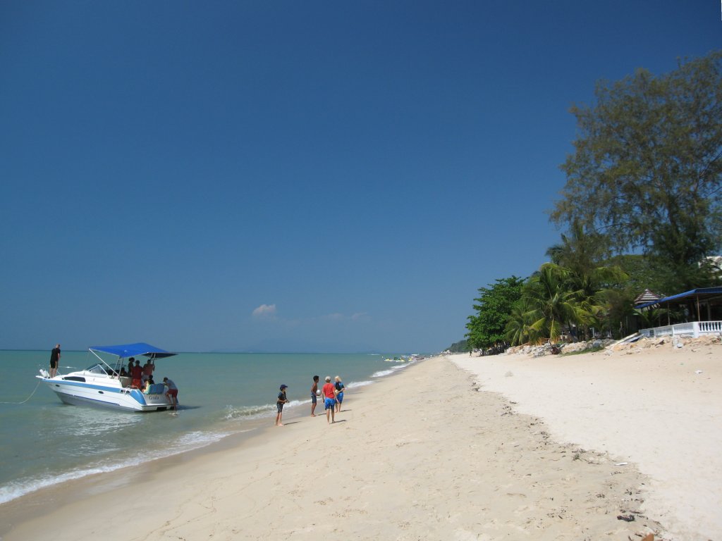
Batu Ferringhi, George Town, Penang 2023.jpg

Penang, MY

Batu Ferringhi

In July 2026 Penang buried 62 sand-filled containers along 44 meters of shoreline fronting the hotel that opened this coast in 1948.

Batu Ferringhi, George Town, Penang 2023.jpg · <a href="//commons.wikimedia.org/w/index.php?title=User:HundenvonPenang&amp;action=edit&amp;redlink=1" class="new" title="User:HundenvonPenang (page does not exist)">HundenvonPenang</a> · CC BY-SA 4.0
Nearest airport
BWH · 16 km
I’m here for
Story

Batu Ferringhi is a roughly 4-kilometer hotel strip on Penang Island's north coast, Malaysia, facing the Strait of Malacca about 11 kilometers northwest of George Town's UNESCO-listed core. The 2020 census counted 9,046 residents in the area's 2.3 square kilometers: roughly 46% Chinese, 22% Malay, 16% Indian, 16% non-citizens. Unlike beaches built around a fishing village or a landmark, this one grew up around hotels; nearly every meter of shoreline fronts a resort, a restaurant, or the road serving them.

The name stacks two languages. "Batu" is Malay for rock. "Ferringhi" comes from Malay "peringgi," a word for Portuguese traders that widened to mean any European, tracing through Persian and Arabic "farangi" to "Frank." Tamil speakers call the same stretch "Paringgi Malai," foreigner's hill. The label predates tourism: English privateer James Lancaster is recorded as the first European to reach Penang island, arriving in 1592 aboard the Edward Bonaventure.

The first hotel here opened in 1948, when Australian doctor Albert S. McKern converted a beachfront bungalow into a ten-room family hotel he named Lone Pine, mistaking a casuarina tree for a pine. It expanded through the 1950s and 1960s, and by the 1970s a wider wave of hotel construction had turned the coastal road, Jalan Batu Ferringhi, into Penang's resort strip proper.

On 26 December 2004, the Indian Ocean tsunami struck Penang's north coast, and Batu Ferringhi was among the hardest-hit stretches on the island. The disaster killed 52 people across Penang state; along the strait's exposed shorelines, the sea's initial withdrawal is recorded as having drawn curious onlookers onto the newly bare sand before the waves returned.

The beach has needed rescuing more than once. In February 2013, Penang's council pledged to fix declining water quality after hotel guests were stung by jellyfish traced to untreated sewage from nearby kampungs and beachfront restaurants. In 2026 the problem is the sand itself: over 33 days from 8 July to 10 August, the state's Department of Irrigation and Drainage buried 62 stacked sand-filled beach containers along the worst-eroded 44 meters, directly in front of the Lone Pine Hotel. The RM500,000 job is rated to hold two to three years. A RM61 million permanent fix, approved in April 2025, was still shopping for a consultant when the temporary one went into the ground.

The spike

In July 2026 Penang buried 62 sand-filled containers along 44 meters of shoreline fronting the hotel that opened this coast in 1948.

Drive along Jalan Batu Ferringhi in the second half of 2026 and the beach in front of the Lone Pine Hotel looks like a construction site that wandered onto the sand. It is one. Between 8 July and 10 August, crews from Penang's Department of Irrigation and Drainage (DID) buried 62 sand-filled beach containers in trenches along a 44-meter stretch of shoreline. The job cost RM500,000 (roughly USD 106,000) and is designed to do one thing: slow the water down before it takes any more sand.

What a "beach container" actually is. Despite the name, this is not a shipping container. It is a large sand-filled fabric container, buried below the beach surface in a stacked wall, functioning as a submerged breakwater that absorbs wave energy before it reaches the visible shoreline. Penang's state infrastructure, transport, and digital committee chairman, Zairil Khir Johari, described the goal plainly: reduce the impact of waves on the shoreline, slow the rate of erosion, and protect the most severely affected section while a permanent project is designed. He also stated the alternative plainly — delay, and the erosion moves inland toward "permanent structures, public amenities and infrastructure located near the shoreline." The work itself was constrained by the tide: DID could only install containers during low-water windows, with no direct machinery access to the beach, meaning materials and spoil had to be handled twice.

Why the sand is going. This is not a mystery. In December 2024, Universiti Sains Malaysia marine ecologist Mahadi Mohammad identified Batu Ferringhi as one of Penang's critical erosion hotspots, alongside Tanjung Bungah and Teluk Bahang, with erosion rates of 0.5 to 1 meter a year in the worst-affected sections — faster during storms. He attributed the trend to a combination that is, in effect, the beach eating its own success: rising sea levels and stronger monsoon-season storm surge on one side, and on the other, the dense hotel and road construction that built Batu Ferringhi's tourism economy in the first place. Concrete and seawalls disrupt the natural flow of sediment along the coast; land reclamation and the loss of mangrove buffer elsewhere in the system remove the sand that would otherwise replenish this stretch; legal and illegal sand mining upstream depletes the supply further; and pollution damages the beach vegetation that would otherwise hold what sand remains. The resort strip did not cause erosion by accident. It is a plausible, documented contributor to the very problem now being patched with buried sandbag containers.

The gap between funded and built. The sand-filled containers are a stopgap, and officials have said so from the start — rated to hold for two to three years, "depending on weather and tidal conditions." The actual fix, a comprehensive coastal protection project with coastal defense structures, an outfall structure, and beach nourishment, was approved April 2025 under the 12th Malaysia Plan with a federal RM61 million allocation. Fifteen months later, when the temporary containers went into the sand, that larger project was still in the consultant-appointment stage — not designed, not tendered, not built. A beach can get emergency triage inside a month. It took over a year for the state to finish choosing who would draw up the real plan.

Why this beach specifically. Batu Ferringhi is not an incidental stretch of coastline; it is Penang's original resort beach, built up hotel by hotel since 1948, when Lone Pine opened as a ten-room bungalow-turned-hotel. The 44-meter section now walled with sand-filled containers sits directly in front of that same hotel, 78 years after it opened. The image is almost too literal: the oldest hotel on the strip, its beachfront now defended by a buried wall of sand-filled containers because the sand it was built to sell is measurably leaving. Batu Ferringhi's other recent environmental episode — a 2013 water-quality crisis driven by untreated sewage from nearby kampungs and beachfront restaurants, serious enough that hotel guests were being stung by jellyfish — follows the same pattern: a manufactured tourism coast whose infrastructure keeps outpacing the maintenance and planning needed to keep it stable. The 2026 beach containers are not a story about a single storm. They are the latest instance of a coast that was built fast, in phases, since the 1970s, and is now being defended the same way: reactively, in pieces, while the comprehensive answer sits in a procurement queue.

None of this means the beach is not busy, or that the hotels are not full, or that the night market three streets back does not run every evening as it always has. It means the sand under the deck chairs is contractually rated to last two to three years, and the paperwork for what comes after was, as of mid-2026, still being written.

BatuFerringhi2006.JPG
Culture

Where it shows up

History
  • The "ferringhi" etymology and 1592 first European contact · 1592

    The beach's name preserves a regional word for European foreigners, and its earliest documented tie to that history is English privateer James Lancaster's 1592 arrival on Penang island aboard the Edward Bonaventure.

  • 2004 Indian Ocean tsunami · 2004

    Batu Ferringhi was among the hardest-hit stretches of Penang's north coast when the 26 December 2004 tsunami struck, part of a disaster that killed 52 people across the state.

Other
  • Batu Ferringhi Night Market

    A nightly street market along Jalan Batu Ferringhi selling food, souvenirs, and clothing, documented in Lonely Planet and Time Out Penang guides as a long-running fixture of the strip.

Brand & advertising
  • Hard Rock Hotel Penang · 2009

    Opened 19 September 2009 as the first Hard Rock-branded hotel in Malaysia, on this beach.

Batu Ferringhi Panorama.jpg
History

What happened here

  1. 1592historic

    First recorded European contact with Penang island

    English privateer James Lancaster arrives aboard the Edward Bonaventure, recorded as the first European to reach Penang island; his crew raids shipping in the strait for roughly four months. The word that later names this beach, "ferringhi," describes this category of visitor.

    Wikipedia →
  2. 1948founding

    Lone Pine Hotel opens as the beach's first hotel

    Australian doctor Albert S. McKern converts a beachfront bungalow into a ten-room family-run hotel, naming it Lone Pine after mistaking a casuarina tree on the property for a pine.

  3. 1970cultural

    Resort-strip hotel construction begins in earnest

    Urbanization along the beach accelerates through the 1970s as more hotels are built along Jalan Batu Ferringhi, converting the coastal road into Penang's primary resort strip.

    Wikipedia →
  4. 2004natural

    Indian Ocean tsunami hits Penang's north coast

    The 26 December tsunami strikes Batu Ferringhi and other north-coast beaches; the disaster kills 52 people across Penang state, among the deadliest single events in the area's modern history.

    Wikipedia →
  5. 2009founding

    Hard Rock Hotel Penang opens

    Hard Rock Hotel Penang opens on 19 September 2009 as the first Hard Rock-branded hotel in Malaysia, adding to the beach's hotel-strip identity.

  6. 2013policy

    Municipal council pledges water-quality fix after jellyfish stings

    Following reports of hotel guests stung by jellyfish, Penang's municipal council (MPPP) pledges to clean up coastal water, citing untreated discharge from Kampung Chetty, Kampung Mutiara, and beachfront restaurants and food courts lacking proper waste disposal.

  7. 2025policy

    RM61 million permanent coastal protection project approved

    A long-term coastal protection project for Batu Ferringhi, covering coastal defense structures, an outfall structure, and beach nourishment, is approved under the 12th Malaysia Plan with a RM61 million federal budget; as of July 2026 reporting on the emergency containers, the project remained in the consultant-appointment stage.

  8. 2026policy

    Emergency beach-container erosion works installed

    Over 8 July-10 August, Penang's Department of Irrigation and Drainage installs 62 stacked sand-filled beach containers along a 44-meter stretch fronting the Lone Pine Hotel, an RM500,000 stopgap rated to hold for two to three years while the RM61 million permanent project remains in the consultant-appointment stage.

The honest part
“A RM61 million permanent fix, approved in April 2025, was still shopping for a consultant when the temporary one went into the ground.”

Batu Ferringhi's environmental problems have a pattern: each one gets treated as a discrete engineering fix rather than evidence that the density of hotel construction on this stretch of sand needs rethinking. In 2013 it was untreated sewage from nearby kampungs and restaurants degrading the water enough that hotel guests were stung by jellyfish. In 2025-26 it is the beach itself: erosion of 0.5 to 1 meter a year at this and two neighboring hotspots, driven partly by sea-level rise and monsoon surge and partly by the same seawalls, roads, and concrete that built the resort strip's tourism economy in the first place, according to a Universiti Sains Malaysia marine ecologist's December 2024 assessment.

The response gap is the clearest evidence of the pattern. Penang approved a RM61 million permanent coastal protection project for this beach in April 2025 — outfall structures, coastal defenses, beach nourishment. Fifteen months later, that project was still in the consultant-appointment stage, undesigned and unbuilt, while a RM500,000 stopgap of buried sand-filled containers went into the sand within weeks in front of the Lone Pine Hotel, rated to last two to three years. The state can mobilize fast for triage. Turning a funded, approved project into an actual structure has taken longer than the emergency patch is expected to hold.

Batu Ferringhi Clinic.jpg
Anatomy

The shape of the place

Main hotel strip

45%

The core of Batu Ferringhi's roughly 4-km beachfront, fronted continuously by hotels including Lone Pine, Hard Rock Hotel Penang, and other resort properties along Jalan Batu Ferringhi.

Best for Hotel-based beach access, water sports concessions

Nearly every meter of this stretch fronts hotel property rather than public open shoreline.

Lone Pine erosion barrier stretch

50%

The 44-meter section of shoreline directly fronting the Lone Pine Hotel, now underlaid with 62 stacked sand-filled beach containers installed July-August 2026 as an emergency erosion barrier.

Best for Seeing the 2026 erosion-mitigation works firsthand

Low-tide construction access continued through early August 2026; the containers are buried, not visible as a structure, but mark the most eroded part of the beach.

Jalan Batu Ferringhi night market strip

50%

The roadside stretch of Jalan Batu Ferringhi where the nightly market sets up, running roughly 7pm to midnight with food and souvenir stalls set back from the sand.

Best for Evening food and shopping, not beach access

Operates every night, not seasonally; busiest 7-10pm.

Miami, Moonlight, and Shamrock beach sections

60%

Informal local names for sections of the wider Batu Ferringhi shoreline, used in Penang tourism references alongside the small offshore islet known as Lovers' Isle.

Coordinates are approximate; these are colloquial section names rather than administratively defined zones.

Landmarks

Lone Pine Hotel · 1948

building

The first hotel built on Batu Ferringhi beach, opened by Australian doctor Albert S. McKern as a ten-room family hotel; now a 90-room Marriott Tribute Portfolio property after a 2010 refurbishment, and the hotel directly behind the 2026 erosion-barrier works.

Jalan Batu Ferringhi (Federal Route 6)

road

The coastal road running the length of the beach, the spine of the resort strip and the site of the nightly night market; served by Rapid Penang bus routes 101 and 102.

Wikipedia →

Lovers' Isle

natural_feature

A small offshore islet listed among Batu Ferringhi's named attractions in Penang tourism references; verified as a real, named feature but without further documented history.

A day here

From first light to dark

Dawn

Low tide in the early hours is when the Department of Irrigation and Drainage's crews can access the buried-container work zone at all; the 44-meter stretch in front of Lone Pine Hotel has been an active low-tide construction window through early August 2026, off-limits to swimmers at those hours.

Midday

The strip runs on hotel infrastructure — pools, restaurants, water-sports counters — more than on the beach itself; midday sun over the Strait of Malacca's typically calm water (annual mean wave height 0.48 m, per reanalysis modeling) draws swimmers to the sections away from the erosion barrier.

Golden hour

Evening light over the strait faces west-northwest across calm water; the buried erosion-barrier construction zone in front of Lone Pine, active through early August 2026, sits beneath the re-sanded beach itself, out of sight during the sunset view.

Night

Jalan Batu Ferringhi's night market runs every evening, roughly 7pm to midnight, busiest between 7 and 10, with stalls set back from the beach itself along the main coastal road rather than on the sand.

Cmglee Penang Boon Siew Villa.jpg
Sea & surf

What the water does

JFMAMJJASONDmetres (significant wave height)

Solid = typical monthly wave height; pale = the bigger days (90th pct). Offshore/regional swell from Open-Meteo Marine (ERA5 Ocean reanalysis, 2023–2024); a sheltered cove may sit calmer than this.

Calm — gentle swimming water most of the year
Typical wave height
0.48 m
Biggest swell
Sep · 0.78 m
Calmest
Apr · 0.27 m
Typical period
6.2 s (wind chop)
Before you go

Things to know

Active erosion works

A 44-meter stretch of beach in front of the Lone Pine Hotel had active low-tide construction through early August 2026 as 62 sand-filled beach containers were installed; expect fencing or restricted access on that section if visiting in that window.

The real airport is not the one in some distance databases

Some datasets list this beach's nearest airport as RMAF Butterworth Air Base, a Royal Malaysian Air Force base on the mainland with no civilian passenger service. The airport travelers actually use is Penang International Airport (PEN), about 25 km and roughly 47-50 minutes by road, on the same island.

Water quality has a documented history of problems

In 2013, Penang's municipal council publicly acknowledged declining water quality tied to untreated sewage discharge and jellyfish stings; no more recent official water-quality rating for this specific beach was found in current research, so treat the 2013 record as dated rather than as a current-status claim.

Night market is nightly, not seasonal

The Jalan Batu Ferringhi night market runs every evening, roughly 7pm to midnight, rather than on fixed seasonal days.

Swimming

Usually calm water — among the gentler beaches for a swim.

Sharks

No incidents on record in the global shark-attack file.

Plan

If you go

Getting there
Nearest airport
RMAF Butterworth Air Base (BWH) · 16 km
Nearest town
Tanjung Tokong · 7 km

Batu Ferringhi sits on Penang Island's north coast, about 11 km northwest of George Town by road and reachable via Rapid Penang bus routes 101 and 102 from George Town's Komtar terminal, or by car along Jalan Batu Ferringhi (Federal Route 6). The nearest civilian airport is Penang International Airport (PEN), roughly 25 km and about 47-50 minutes away by road; RMAF Butterworth Air Base, sometimes listed as the nearest airport by straight-line distance (16.1 km, across the strait on the mainland), is a military installation with no civilian passenger service and is not a usable travel option.

When to go
  • Batu Ferringhi Night Market · Every night, roughly 7pm-midnight

    A nightly market along Jalan Batu Ferringhi with food stalls (satay, grilled fish, sweets), souvenirs, and clothing; runs year-round rather than on a seasonal schedule.

What to eat & drink
Night market satay and grilled fish

Street-stall satay and grilled fish are the market's core draw, alongside sweets, sold from stalls set up nightly along the roadside.

Jalan Batu Ferringhi night market, nightly ~7pm-midnight

Asam laksa

Penang's signature sour, fish-based noodle soup; not a Batu Ferringhi dish specifically but the island's best-known hawker export, found at hawker centers in George Town rather than on this beach.

George Town hawker centers, ~11 km southeast

Char kway teow

Wok-fried flat rice noodles with prawns, egg, and Chinese sausage; another Penang hawker staple more readily found in George Town's hawker courts than beachfront at Batu Ferringhi.

George Town hawker centers, ~11 km southeast

batubar and Matsu (Lone Pine Hotel)

The two in-house dining outlets added in Lone Pine Hotel's 2010 refurbishment — batubar and the Japanese restaurant Matsu — are verified, on-property beachfront dining rather than street food.

Lone Pine Hotel, Batu Ferringhi beachfront

Sources & references
  1. Wikipedia: Batu Ferringhi · cited 6×
  2. Lone Pine Hotel official history · cited 2×
  3. New Straits Times, Apr 2025; The Star, 26 Jan 2026 · cited 2×
  4. Hard Rock Hotel Penang; multiple hospitality trade sources, 2009
  5. The Star, 6 Feb 2013, "Sea change for Batu Ferringhi"
  6. Malay Mail, 14 Jul 2026; The Star, 18 Jul 2026; Free Malaysia Today, 14 Jul 2026
  7. Department of Statistics Malaysia, MyCensus 2020 (published Feb 2024)
  8. The Star, 18 Jul 2026; Malay Mail, 14 Jul 2026
  9. Scoop, 8 Dec 2024, citing Assoc. Prof. Mahadi Mohammad, USM
Colophon · Provenance

Where this page comes from

Geography, facilities
OpenStreetMap (ODbL) for geometry and facility tags within 500 m of the beach centroid. GeoNames for city/airport distances.
Climate & ocean
Open-Meteo ERA5 + Marine archive, 2014–2023 monthly normals.
Photography
Archival, original tone (Tier B — Wikimedia Commons). Each image licensed per its own terms; attribution visible inline.
History & culture
Every factual claim is linked to its source in the prose above. Wikipedia citations inline. Non-wiki sources named where relevant.
Editorial voice
Register: wry. Written to pass a local's nod test; corrections welcome.
Written by Erin Rose
Last reviewed 2026-04-19
v0.9 — in editorial development toward v1.0