California, US

Black's Beach

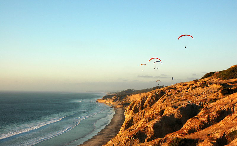
Black's Beach, La Jolla, San Diego, California 03.jpg

California, US

Black's Beach

The Scripps submarine canyon funnels open-ocean swell into this cliff-base beach, making it both a serious surf break and a place that has killed people.

Black's Beach, La Jolla, San Diego, California 03.jpg · <a href="//commons.wikimedia.org/wiki/User:Leviclancy" class="mw-redirect" title="User:Leviclancy">Levi Clancy</a> · CC BY-SA 4.0
Length
5.4 km
Spring tide
1.40 m
Nearest airport
NKX · 11 km
Tier
Featured
I’m here for
Story

Black's Beach runs along the foot of sandstone cliffs that rise up to 300 feet (91 m) above the sand in La Jolla, on the northern edge of San Diego. There is no road down. You arrive on foot, by trails cut into a bluff that the City of San Diego officially tells you not to use, and the descent is the first honest fact about the place: roughly 300 vertical feet of loose, eroding rock. The reward at the bottom is a beach most San Diegans know by reputation before they ever stand on it.

The beach carries two official names and a third everyone actually uses. The northern half is Torrey Pines State Beach, run by California State Parks. The southern half is Torrey Pines City Beach, run by the City of San Diego. "Black's" is the name that stuck — after the Black family, who once kept a horse ranch on the bluff above and later sold the land that became the La Jolla Farms lots.

What makes Black's singular is not visible from the sand. Just offshore, the Scripps submarine canyon cuts toward the coast, and it works like a funnel: it focuses open-ocean swell and concentrates wave energy onto this stretch. Surfers know the southern end as one of the most powerful beach breaks in Southern California. The same canyon that draws them makes the water dangerous for anyone who underestimates it.

Above the beach sits the Torrey Pines Gliderport, where Charles Lindbergh made the first soaring flight above these cliffs on February 24, 1930. On most days with onshore wind, paragliders and hang gliders launch off the bluff edge directly over the surf. The Salk Institute, the Torrey Pines golf course, and the UC San Diego campus all sit within walking distance to the east.

Black's is also, for a stretch of its length, clothing-optional — a status that has been legal, then illegal, then quietly tolerated, and remains a grey area to this day. It was, for a few years in the mid-1970s, the first and only officially sanctioned public nude beach in the United States. That history is real, specific, and unfinished.

The spike

The Scripps submarine canyon funnels open-ocean swell into this cliff-base beach, making it both a serious surf break and a place that has killed people.

The thing that makes Black's Beach worth a page of its own is invisible from the sand: a submarine canyon. Most beaches are shaped by what you can see — a headland, a reef, a river mouth. Black's is shaped by a deep trench in the seafloor just offshore, the Scripps Canyon, part of the larger La Jolla submarine canyon system that incises the continental shelf within a few hundred meters of the shoreline. That trench is why this otherwise unremarkable strip of sand under a cliff is, to surfers, one of the most serious waves in Southern California.

How a canyon makes a wave. Open-ocean swell travels in long, low lines until it reaches shallow water, where it slows, steepens, and breaks. Where the seafloor is uniform, that energy spreads out evenly and you get gentle, even surf. Where the seafloor is irregular, the energy bends. Waves refract — they turn toward shallow water and away from deep water — and a submarine canyon does both at once. The deep canyon axis pulls energy in along its flanks and concentrates it on the points where the canyon walls meet the beach. The result at Black's is a beach break that can be two or three times the size of the surf at flatter beaches a mile away on the same swell. A south or west swell that produces shoulder-high mush elsewhere can stand up overhead at Black's. That is the entire reason the southern end has the reputation it does.

Why the same canyon is dangerous. The physics that concentrate swell for surfers also concentrate it for everyone else. Wave energy focused onto a narrow zone drives strong, fast rip currents, and the steep nearshore profile — the modeled nearshore depth here is around 54 m, unusually deep close in for a California beach — means there is no long, gentle shelf to soften an incoming set. The water gets deep fast. Combine that with no lifeguard tower on the remote northern stretches, a long walk back to any help, and a cliff that blocks an easy exit, and you have a beach that punishes the unprepared. Lifeguards do patrol, with funding help from UC San Diego, but coverage is not the same as the staffed, towered, flag-lined supervision of a city beach like Mission or Pacific.

The cliff is the second hazard, and it is not theoretical. The bluffs above Black's are layered sandstone and mudstone, and they fail — sometimes slowly, sometimes all at once. In August 2008 a section of cliff collapsed onto the beach at Torrey Pines and killed a 57-year-old visitor, Robert Mellone, who had walked to the base of the bluff; three to five cubic yards of rock came down about 25 feet onto him, and other beachgoers dug him out, though he did not survive. In January 2023 a large section of sea bluff gave way with no injuries, and a local geology professor called it the most significant failure in 40 years. People have also died falling from the top — a 23-year-old in one fall of 50 to 60 feet, and in 2024 a 42-year-old man, Jose Santoyo, who lost his footing on the trail down. The City of San Diego posts "do not use" signs at the Gliderport descent for exactly this reason. None of this is here to scare you off the beach. It is here because a page that sold you the wave without the canyon's other half would be lying.

Why the canyon is also why anything is here at all. The same deep water close to shore is why the Scripps Institution of Oceanography — one of the oldest and most important ocean-research centers in the world — sits just down the coast. Researchers can reach deep-ocean conditions a short boat ride from the pier. The canyon that makes the surf, makes the danger, and helped make San Diego a center of marine science are the same feature. Stand at the bottom of the trail on a big winter day, watch a set wrap in and stand up where the canyon meets the sand, and you are watching seafloor geology write itself onto the surface of the water. That is the spike: at Black's, the wave is a readout of the canyon, and the canyon explains nearly everything else about the place.

Flatrock Point Torrey Pines State Beach La Jolla, CA.JPG
Culture

Where it shows up

History
  • First sanctioned public nude beach in the United States · 1974

    For several years in the mid-1970s, the city portion of Black's was the first and only officially sanctioned public nude beach in the country, before the designation was reversed in 1977.

  • Kitty Hawk of the West · 1930

    The nickname glider enthusiasts give the bluff above the beach, where soaring flight in California effectively began with Lindbergh's 1930 flight.

Other
  • Black's as a Southern California surf break

    Among California surfers, the southern end of Black's is widely regarded as one of the most powerful beach breaks in the region, a reputation built on the canyon-focused swell rather than any reef or point.

Blacks surfer.jpg
History

What happened here

  1. 1930milestone

    Lindbergh's first soaring flight above the cliffs

    On February 24, 1930, Charles Lindbergh made the first sailplane soaring flight above the Torrey Pines cliffs, helping establish the bluff as the "Kitty Hawk of the West."

    Wikipedia →
  2. 1974designation

    Swimsuit-optional designation

    In the mid-1970s the city portion of the beach was officially designated swimsuit-optional, making Black's the first and only sanctioned public nude beach in the United States for several years.

    Wikipedia →
  3. 1977regulation

    Nudity prohibited on the city portion

    By 1977 nudity was prohibited on the City of San Diego portion of the beach, ending the official sanction. The state-park portion has remained clothing-optional by tolerance.

    Wikipedia →
  4. 1993designation

    Gliderport added to National Register

    The Torrey Pines Gliderport on the bluff above the beach was added to the National Register of Historic Places on July 12, 1993.

    Wikipedia →
  5. 2008disaster

    Fatal cliff collapse

    A section of bluff collapsed onto the beach, dropping three to five cubic yards of rock about 25 feet onto 57-year-old visitor Robert Mellone, who died of his injuries despite being dug out by other beachgoers.

  6. 2023disaster

    Major bluff failure

    A large section of sea bluff above the beach collapsed with no injuries reported; a local geology professor called it the most significant failure in roughly 40 years.

  7. 2024disaster

    Fatal fall on the access trail

    Jose Santoyo, 42, of San Diego died after losing his footing while hiking down the sea bluff trail to the beach, one of several fall fatalities on the cliffs.

The honest part
The cliff that frames every photograph is the same cliff that has fallen on people; the canyon that makes the wave is the same canyon that makes the rip.

Black's earns its mystique and its danger from the same facts. The cliff that frames every photograph is actively failing — a 2008 collapse killed a man at the base, a 2023 failure was called the worst in 40 years, and people have died falling from the top, including a hiker on the trail in 2024. The descent itself carries an official "do not use" sign. In the water, the submarine canyon that draws expert surfers drives powerful rips, and long stretches have no lifeguard within reach. The clothing-optional tradition occupies a real legal grey zone: officially sanctioned in the mid-1970s, prohibited on the city portion by 1977, and merely tolerated since — which means enforcement is unpredictable and depends on which jurisdiction's sand you are standing on.

None of this makes Black's a bad beach. It makes it a beach with consequences. The people who love it know the tide chart, the swell forecast, and which trail is least likely to give way, and they treat the place as a serious environment rather than a postcard.

TorreyPinesBeach2008.jpg
Anatomy

The shape of the place

Southern surf break

20%

The powerful beach break that gives Black's its surf reputation, fed by the offshore Scripps submarine canyon. Best on a winter swell; not a place for inexperienced swimmers.

Best for Experienced surfers on a real swell.

Rips are strong here. The canyon focuses energy onto this end.

Gliderport trailhead (top)

50%

The most-used way down, starting from the dirt parking lot beside the Torrey Pines Gliderport. The City posts a "do not use" sign here because the trail descends roughly 300 feet over loose, unstable terrain. This is also the best free viewpoint of the whole beach.

Best for First-timers willing to take the steep route; the clifftop view even if you don't descend.

Free dirt parking. Watch paragliders launch off the rim directly over the surf.

Clothing-optional stretch (north of access)

65%

The roughly 1.1-mile section, beginning north of the Salk-canyon access, where the clothing-optional tradition is concentrated and tolerated on the state-park sand.

Best for Naturists; quieter beach time away from the surf crowd.

Legal grey area; enforcement varies by jurisdiction. Be aware of which half you're on.

Northern remote stretch

90%

The far northern sand toward Torrey Pines State Beach proper, long and empty, with the cliff at your back and no quick exit.

Best for Long, solitary walks at low tide.

No towered lifeguard here. Mind the rising tide — the cliff can cut off the walk back.

Landmarks

Torrey Pines Gliderport

historic site

Operating gliderport on the bluff above the beach, in use since the late 1920s, where Lindbergh made the first soaring flight on Feb 24, 1930. Added to the National Register of Historic Places on July 12, 1993. Paragliders and hang gliders still launch over the surf.

Wikipedia →

Salk Institute for Biological Studies · 1965

research institute · Louis Kahn

Louis Kahn's landmark concrete research campus sits on the bluff just south of the beach, its central courtyard famously open to the Pacific. A short walk from the clifftop.

Wikipedia →

Scripps Institution of Oceanography · 1903

research institution

One of the oldest and largest centers for ocean and earth science in the world, just down the coast, able to reach deep water quickly thanks to the same submarine canyon system offshore.

Wikipedia →
A day here

From first light to dark

Dawn

Offshore wind holds the swell lines clean and the trails are empty. On a winter morning the canyon-focused sets are at their biggest and the southern break draws the surfers who know it; the long walk down means you are mostly alone at the bottom.

Midday

The onshore wind fills in and the paragliders launch off the Gliderport bluff directly over the beach. Sun is hard on the pale sandstone. On a low tide the sand widens and the clothing-optional stretch north of the access fills with regulars.

Golden hour

Late light turns the 300-foot cliff face warm orange — the reason most photographs of Black's are shot at this hour, from the Gliderport rim looking down. Surfers thin out as the wind drops back offshore.

Night

The beach empties fast because the only way out is back up an unlit, unstable trail. There are no facilities at the base and no reason to linger after dark; the cliff is more dangerous when you cannot see your footing.

Compare

How it ranks

Peak warmth
Cooler than 91% of beaches in its country
Peak-month high ≈ 23°C
Beach season
Longer beach season than 79% of beaches in its country
8 comfortable months a year

Ranked against every beach in our database — 228,000+ worldwide.

Blacks-Beach-Road-From-UCSD.jpg
Sea & surf

What the water does

JFMAMJJASONDmetres (significant wave height)

Solid = typical monthly wave height; pale = the bigger days (90th pct). Offshore/regional swell from Open-Meteo Marine (ERA5 Ocean reanalysis, 2023–2024); a sheltered cove may sit calmer than this.

Mixed — usually swimmable, with a livelier season
Typical wave height
1.16 m
Biggest swell
Jan · 1.62 m
Calmest
Jul · 0.93 m
Typical period
11.1 s (groundswell)
Before you go

Things to know

The trail down is the real risk

All routes descend roughly 300 feet of loose, eroding cliff. The City posts "do not use" signs at the Gliderport trail. Wear real shoes, go slow, and do not cut switchbacks. Falls here have been fatal.

No lifeguard tower on the remote stretches

Lifeguards patrol with UC San Diego funding help, but the northern and remote sections have no staffed tower. The canyon-driven rips are strong; this is not a beach for weak or inexperienced swimmers.

Watch the tide

A rising tide narrows the sand against the cliff and can cut off the walk back. Check the tide chart before you go down, especially on the long northern stretch.

Clothing-optional is a grey area

The state-park half tolerates nudity; the city half officially prohibits it. Enforcement varies and depends on which jurisdiction's sand you are on. Bring a suit and know where you are.

Sharks

No incidents on record in the global shark-attack file.

Lifeguard

No lifeguard service — swim within your limits.

Plan

If you go

Getting there
Nearest airport
Miramar Marine Corps Air Station - Mitscher Field (NKX) · 11 km
Nearest town
La Jolla · 5 km

There is no road to the beach. Most visitors park free in the dirt lot at the Torrey Pines Gliderport (2800 Torrey Pines Scenic Dr) and take the steep ~300-foot trail down — the trail the City marks "do not use" because of the unstable cliffs. Alternative routes descend from the La Jolla Farms / Salk-canyon access road and the longer paved Black's Beach access road. From the north, you can also walk in along the sand from Torrey Pines State Beach at low tide, but a rising tide can trap you against the cliff. Whichever way you come, allow for a hard climb back out and carry water.

When to go
  • Paragliding and hang gliding over the cliffs · Any day the onshore wind permits, year-round

    Pilots launch from the Torrey Pines Gliderport rim and ride the ridge lift along the cliff face directly above the beach. Not a scheduled event so much as a near-daily feature when conditions allow.

  • Winter big-swell surf sessions · Peak winter, on north and west swells

    The biggest, most focused surf at Black's arrives with winter swells; the southern break draws experienced surfers when the canyon stacks the energy up. Informal, swell-dependent, not organized.

What to eat & drink
Nothing on the sand

There is no food, no kiosk, and no vendor at the base of the cliff. Whatever you carry down the trail is what you have. Plan to bring water — the walk back up in afternoon heat is the part people underestimate.

Black's Beach itself

Fish taco

The San Diego standard — grilled or battered white fish, cabbage, crema, lime — is the regional dish to eat after the climb out, found at taco shops throughout La Jolla and nearby Torrey Pines.

La Jolla / Torrey Pines, uphill from the beach

California burrito

A San Diego invention: carne asada, cheese, and french fries rolled into a flour tortilla. Heavy, local, and exactly what a post-surf appetite wants.

Taco shops across San Diego

Coffee at the Gliderport cafe

The cafe at the Torrey Pines Gliderport sits on the clifftop with the view down onto the beach and the launching paragliders — the practical regroup point at the top of the trail.

Torrey Pines Gliderport, on the bluff above

Sources & references
  1. Wikipedia: Black's Beach · cited 6×
  2. Wikipedia: Torrey Pines Gliderport · cited 4×
  3. World Beach Tour dataset · cited 2×
  4. Surfer / cbs8.com news reports
  5. La Jolla Light, Jan 21, 2023
  6. San Diego news reports
Colophon · Provenance

Where this page comes from

Geography, facilities
OpenStreetMap (ODbL) for geometry and facility tags within 500 m of the beach centroid. GeoNames for city/airport distances.
Climate & ocean
worldclim_v2.1_2.5m
Tides
eot20
Photography
Archival, original tone (Tier B — Wikimedia Commons). Each image licensed per its own terms; attribution visible inline.
History & culture
Every factual claim is linked to its source in the prose above. Wikipedia citations inline. Non-wiki sources named where relevant.
Editorial voice
Register: technical. Written to pass a local's nod test; corrections welcome.
Written by Erin Rose
Last reviewed 2026-04-19
v0.9in editorial development toward v1.0