Balearic Islands, ES

Cala d'Hort

Ibiza rock volcano (747230830).jpg

Balearic Islands, ES

Cala d'Hort

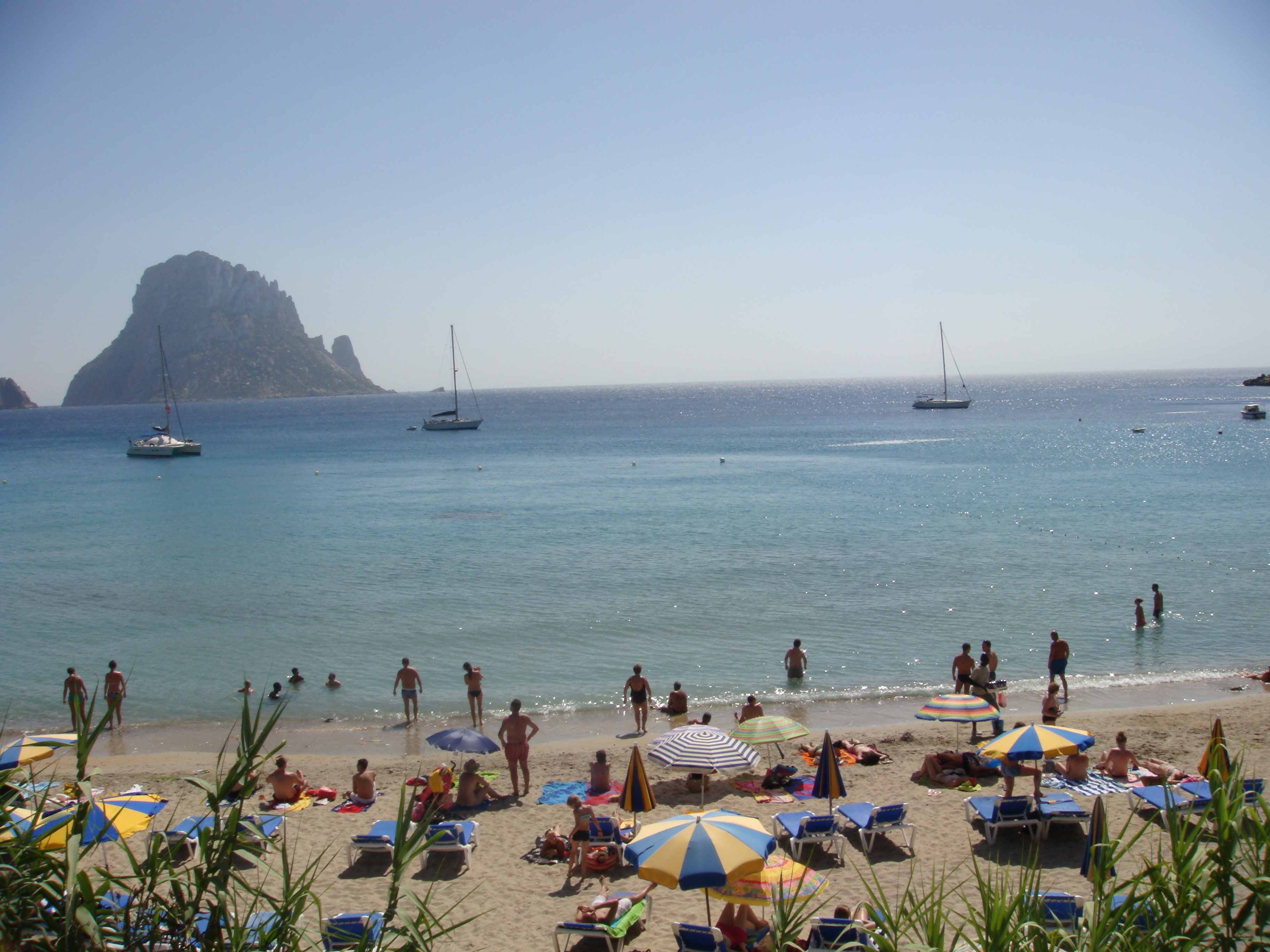
The cove is small and ordinary; what makes it famous stands 2.5 km offshore: Es Vedrà, 413 m of bare limestone that the sunset turns to silhouette.

Ibiza rock volcano (747230830).jpg · <a rel="nofollow" class="external text" href="https://www.flickr.com/people/30221626@N00">athinaf</a> · CC BY 2.0
Spring tide
0.05 m
Nearest airport
IBZ · 13 km
Tier
Featured
I’m here for
Story

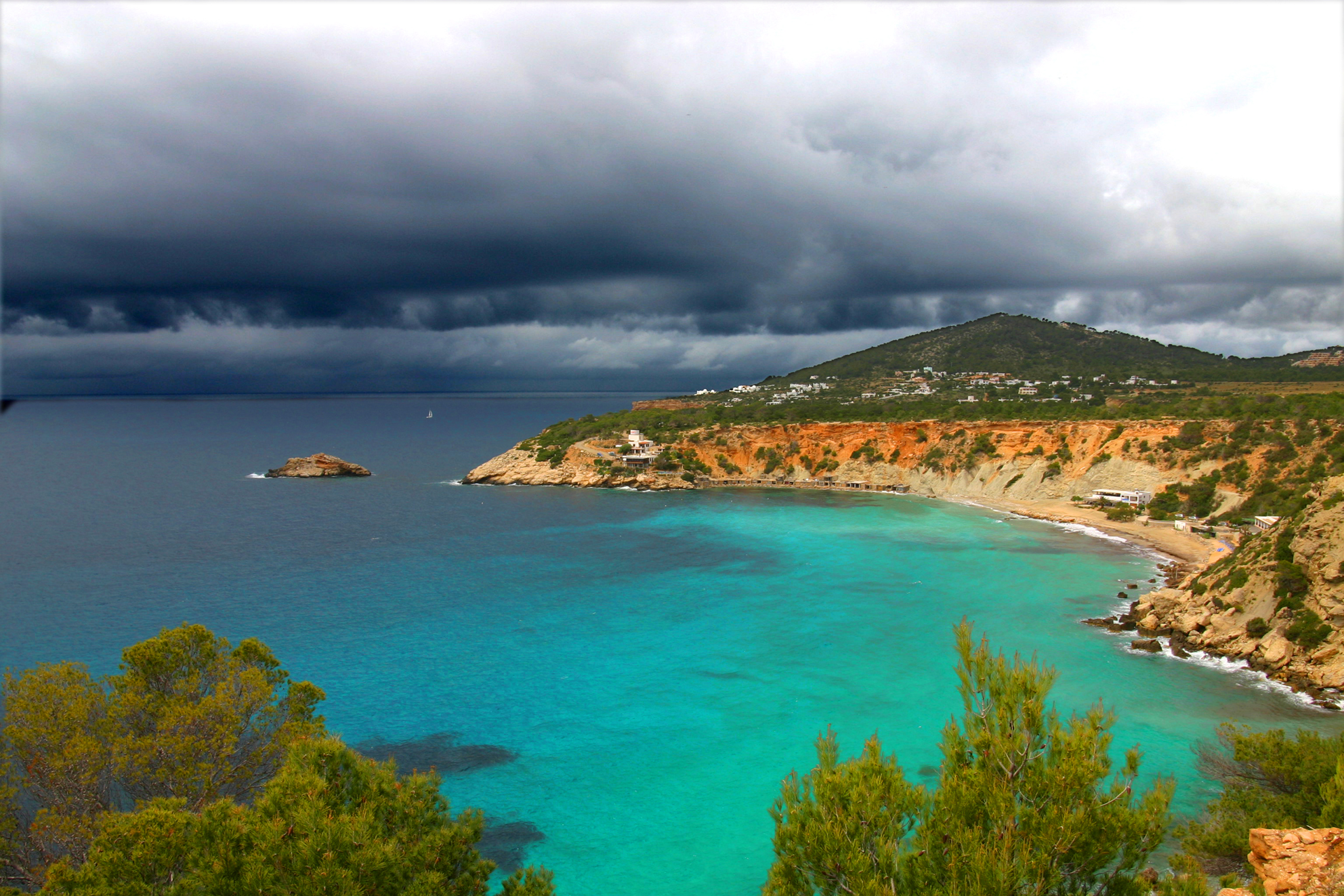
Cala d'Hort is a small cove on the southwest coast of Ibiza, in the municipality of Sant Josep de sa Talaia, about 21 km west of Ibiza Town. The beach itself is roughly 200 meters long and 30 meters wide, divided down the middle: golden sand on one half, coarse shingle and pebbles on the other. By the standards of the island's bigger resort beaches it is unremarkable. People do not come here for the sand.

They come for what sits offshore. About 2.5 km out, rising straight from the water, is Es Vedrà: a single block of bare Mesozoic limestone 413 meters tall, uninhabited, steeper than it has any right to be. From the waterline at Cala d'Hort the rock fills the western horizon, and at sunset the light goes behind it and turns it to a flat silhouette. The cove is, functionally, a viewing platform aimed at a rock.

That rock carries more legend than almost any feature in the western Mediterranean. It has been called the home of the sirens who tried to lure Odysseus, the sacred island of the Phoenician goddess Tanit, and one of the most magnetic places on Earth. The last of those is false in the literal sense, and the others are folklore, not history. What is verifiable is stranger in its own way: the island holds a breeding colony of the endangered Eleonora's falcon, a subspecies of the Ibizan wall lizard found almost nowhere else, and, until 2016, a population of feral goats the regional government shot from boats.

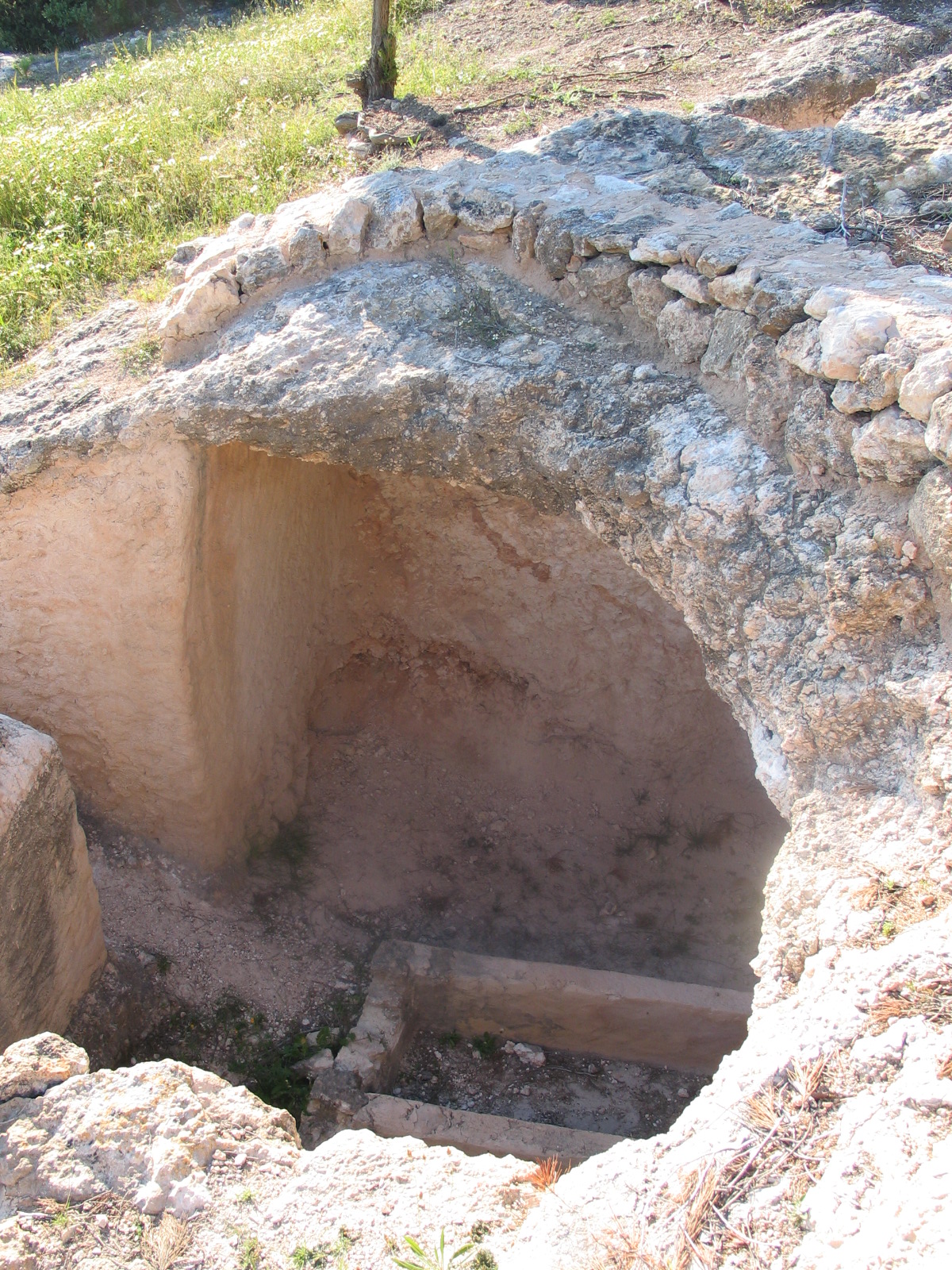
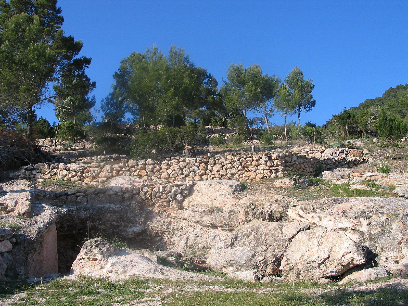
The land behind the beach has a deeper record than the myths. On the headland between Cala d'Hort and Cala Truja are the remains of Ses Païsses de Cala d'Hort, a Punic-Roman rural settlement occupied from the 5th century BC, with an oil mill, a cistern, a winery, and two necropolises. The Phoenicians who founded Ibiza in the 7th century BC really were here; the sirens were not.

The cove looks the way it does because of a fight. In 1998 the regional authorities approved a 420-room hotel and an 18-hole golf course for this stretch of coast. A campaign led by the environmental group GEN-GOB, a march of around 11,000 people in January 1999, and mounting pressure forced the government to halt the project in August 1999. In February 2002 the area was made a natural park. The undeveloped view that draws the crowds is not natural luck. It was won.

The spike

The cove is small and ordinary; what makes it famous stands 2.5 km offshore: Es Vedrà, 413 m of bare limestone that the sunset turns to silhouette.

The honest way to describe Cala d'Hort is that the beach is the frame, not the picture. The strand is about 200 meters of mixed sand and shingle, shallow and calm on most days, pleasant and entirely ordinary. What makes it one of the most photographed coves in the Mediterranean stands 2.5 km out to sea and has nothing to do with the beach at all. That is Es Vedrà, and understanding this place means understanding the rock.

The rock is real, and it is extreme. Es Vedrà is a single mass of Mesozoic limestone rising 413 meters straight out of the water, roughly 2.5 km off the Cala d'Hort shoreline. It is steep on every side, uninhabited, and far more vertical than its small footprint suggests. The limestone is part of the same Betic geology that built the island's western cliffs, lifted into a near-island spire that the sea isolated. From the beach it reads as a dark wedge on the horizon; from a boat at its base it is a wall. It is this verticality, more than any legend, that gives it the presence people respond to. A low offshore island would be a curiosity. A 413-meter rock alone in open water is a monument.

The legends are layered, and most of them are not true. Es Vedrà has accumulated more mythology than almost any rock in the western Mediterranean, and it is worth separating the strands honestly. The oldest associations are Phoenician: Ibiza was founded by Phoenician settlers in the 7th century BC, the goddess Tanit was the island's principal deity, and the rock has long been tied to her cult in local tradition. That is association and folklore, not documented ritual on the island itself. The classical claim, that Es Vedrà is the island of the sirens who tried to lure Odysseus in Homer's Odyssey, is a romantic identification with no basis beyond the wish to place the poem somewhere beautiful. The modern claims are the shakiest. The widely repeated line that Es Vedrà is the third most magnetic place on Earth, after the North Pole and the Bermuda Triangle, is simply false: the rock has no unusual magnetic mineral accumulation, and the claim does not survive a compass. UFO sightings and Atlantis theories belong to the island's 1970s counterculture, not to its geology. None of this should be dressed up as fact. The rock is remarkable enough without it, and the most interesting thing about the mythology is that the mythology exists at all, attached to a place that is, physically, just very large and very steep.

The verifiable life on the rock is the better story. Es Vedrà holds a breeding colony of Eleonora's falcon (Falco eleonorae), a small migratory raptor that nests on Mediterranean cliffs and times its breeding to the autumn songbird migration it hunts. The rock is also home to a distinct subspecies of the Ibizan wall lizard, Podarcis pityusensis, the same protected reptile that gives the beach's own scrubland its small green-and-blue residents. For decades the island also carried feral goats. In February 2016 the regional government sent agents by boat to shoot them, on the argument that grazing was destroying the endemic flora the falcons and lizards depend on. The cull was completed in a single day, the carcasses left where they fell, and it set off a public fight: a petition gathered more than 15,000 signatures, councillors were threatened, and the episode became a small scandal about how a protected rock should be managed. That is the real drama of Es Vedrà, and it is ecological, not paranormal.

The undeveloped view is the result of a defeated resort. The reason Cala d'Hort still looks across an empty headland to a bare rock is that a development was beaten here. In 1998 the regional authorities approved a project for a 420-room hotel and an 18-hole golf course on this coast, with a desalination plant to water it. The environmental coalition GEN-GOB had been campaigning against building here since 1992, and the 1998 approval turned the campaign into a movement. In January 1999 a march estimated at around 11,000 people, a substantial share of the island's population, took to the streets, and in August 1999 the local government stopped the development. In February 2002 the area was protected as a natural park, the Parc Natural de Cala d'Hort, Cap Llentrisca i sa Talaia, covering roughly 2,208 hectares, with the islets of Es Vedrà and Es Vedranell as nature reserves. The clean sightline that every sunset photograph depends on is not wilderness that happened to survive. It is a golf course that was stopped.

And then there is the crowd. All of this, the rock, the myth, the protected emptiness, converges at one moment each day. Cala d'Hort faces west, the sun sets behind Es Vedrà, and the result is one of the most reliable sunset spectacles in Ibiza. In peak season the small beach and the clifftop above it fill with people aimed at the same horizon, the parking lot overflows by mid-afternoon, and cars line the narrow approach road. The cove that exists to look at a quiet rock is, at the hour it is most worth seeing, not quiet at all.

Ibiza, Spain (2662925415).jpg
Culture

Where it shows up

Literature
  • The sirens of the Odyssey
    Homer

    Es Vedrà is popularly identified as the island of the sirens who tried to lure Odysseus in Homer's Odyssey. The identification is folklore with no textual or historical basis, but it is one of the rock's most repeated associations.

History
  • Tanit and Phoenician Ibiza

    Ibiza was founded by Phoenician settlers in the 7th century BC and Tanit was its principal goddess; statues and figures of her have been found across the island. Local tradition ties Es Vedrà to her cult, an association rather than documented on-island ritual.

  • The 'most magnetic place' myth

    A widely circulated claim holds that Es Vedrà is the third most magnetic place on Earth after the North Pole and the Bermuda Triangle. It is false: the rock has no unusual magnetic mineral content. The claim is part of the island's modern esoteric folklore, not its geology.

  • Friar Francis Palau's retreat · 1855
    Francis Palau y Quer

    The Carmelite friar Francis Palau, exiled from Barcelona, spent periods of solitary retreat on Es Vedrà around 1855, one of the few documented human associations with the uninhabited rock.

Begraafplaatsfeniciërs 5-05-2007 18-45-22.jpg
History

What happened here

  1. -600historic

    Phoenician settlement of Ibiza

    Phoenician settlers found the colony that becomes Ibiza in the 7th century BC, establishing the Punic culture whose goddess Tanit is later associated in local tradition with Es Vedrà.

    Wikipedia →
  2. -500historic

    Ses Païsses de Cala d'Hort occupied

    A Punic-Roman rural settlement on the headland behind the cove is established and remains in use from roughly the 5th century BC into late antiquity, with an oil mill, cistern, winery, warehouses and two necropolises.

  3. 1855cultural

    Friar Francis Palau on Es Vedrà

    The Carmelite friar Francis Palau y Quer, exiled from Barcelona, spends periods of solitary retreat on Es Vedrà, one of the few documented human associations with the otherwise uninhabited rock.

    Wikipedia →
  4. 1982cultural

    Ses Païsses excavated

    A full archaeological investigation of the Ses Païsses de Cala d'Hort settlement is carried out between 1982 and 1984 under the direction of Joan Ramón Torres, with further minor works in the 1990s.

  5. 1992policy

    GEN-GOB campaign begins

    The environmental group GEN-GOB begins campaigning against proposed development on the Cala d'Hort coast, the start of a decade-long fight to keep the area undeveloped.

    Wikipedia →
  6. 1998policy

    Hotel and golf course approved

    Regional authorities approve a development for the Cala d'Hort area comprising a 420-room hotel, an 18-hole golf course and a desalination plant, escalating the conservation campaign into a mass movement.

    Wikipedia →
  7. 1999policy

    March of around 11,000 people

    In January 1999 a protest march estimated at roughly 11,000 people, a large share of the island's population, demonstrates against the approved development.

    Wikipedia →
  8. 1999policy

    Development halted

    In August 1999 the local government stops all development plans for the Cala d'Hort coast, preserving the undeveloped sightline to Es Vedrà.

    Wikipedia →
  9. 2002policy

    Natural park declared

    In February 2002 the area is protected as the Parc Natural de Cala d'Hort, Cap Llentrisca i sa Talaia, around 2,208 hectares, with Es Vedrà and Es Vedranell designated nature reserves.

    Wikipedia →
The honest part
The clean sightline every sunset photo depends on is not surviving wilderness. It is a golf course that was stopped.

Three uncomfortable truths sit under the postcard. The first is that the empty, undeveloped view is not a gift of nature but the outcome of a development fight: a 420-room hotel and an 18-hole golf course were approved here in 1998, and only a sustained campaign and an 11,000-strong march in 1999 stopped them. Protection came in 2002. The view you photograph is a resort that lost. The second is the gap between the myth and the rock. Es Vedrà is sold as the third most magnetic place on Earth and the island of the sirens; the magnetism is measurably false and the sirens are folklore. The rock is genuinely extraordinary, 413 meters of bare limestone with a colony of endangered falcons, and it does not need the invented mysticism layered onto it for the tour boats.

The third is the crowd. Cala d'Hort is small, around 200 meters of sand and shingle, with limited parking that fills by mid-afternoon in summer. Because it faces the sunset, the worst crowding arrives at the exact moment people come for. The lot overflows onto an uneven verge, cars line the access road, and the clifftop terrace at Es Boldado is packed. The cove's whole appeal, a calm view of a lonely rock, is hardest to find at the hour it is most famous for.

Es vedra.jpg
Anatomy

The shape of the place

The sandy half

35%

The golden-sand half of the ~200 m cove, shallow and calm on most days and the part families use. Faces directly west toward Es Vedrà.

Best for Swimming and the head-on sunset view

Fills first in summer; arrive early for both a spot and parking.

Es Vedrà (offshore)

50%

The 413 m limestone islet ~2.5 km offshore that the whole cove is oriented toward. Uninhabited, a nature reserve, with no public landing.

Best for The view; boat trips circle it but cannot land

Eleonora's falcon and an endemic wall lizard live here; access is restricted.

The shingle half

65%

The coarse pebble-and-shingle half of the beach, quieter and harder underfoot, where the older fishermen's boat shelters sit along the back.

Best for A less crowded patch and the boat-shelter character

Water shoes help; the footing is rough compared with the sand side.

Es Boldado clifftop

90%

The raised terrace and restaurant on the cliff at the cove's northern edge, with the most direct elevated line of sight to Es Vedrà and the sunset.

Best for The sunset view with a meal

Packed at sunset in season; historically cash-only with no nearby ATM.

Landmarks

Es Vedrà

natural

A single mass of Mesozoic limestone rising 413 meters straight from the sea about 2.5 km off Cala d'Hort. Uninhabited and protected as a nature reserve, it holds a breeding colony of the endangered Eleonora's falcon and an endemic subspecies of the Ibizan wall lizard. It is the subject of widespread legend, including sirens, the goddess Tanit and a magnetism claim that is measurably false.

Wikipedia →

Ses Païsses de Cala d'Hort

archaeological

A Punic-Roman rural settlement on the headland behind the cove, occupied from roughly the 5th century BC into late antiquity. It preserves an oil mill, a cistern over four meters deep, a winery, warehouses and two necropolises, and was excavated between 1982 and 1984 under Joan Ramón Torres.

Es Vedranell

natural

The smaller, lower islet between Es Vedrà and the Cala d'Hort shore, designated a nature reserve alongside Es Vedrà in the 2002 natural park. It completes the cluster of protected islets off this corner of Ibiza.

A day here

From first light to dark

Dawn

The cove faces west, so dawn leaves it in shadow with the light behind the hills; Es Vedrà sits pale and flat on a calm sea and the small parking lot is nearly empty. This is the quietest the beach gets and the only time the sand is uncrowded in summer.

Midday

Mid-morning to early afternoon the water is at its clearest over the sandy half, shallow and calm enough for children, while the shingle half stays emptier. By mid-afternoon in peak season the lot is full and cars begin lining the verge along the access road.

Golden hour

The hour the whole place exists for: the sun drops toward Es Vedrà, the rock blackens to silhouette, and the sky goes amber then violet behind it. The beach and the clifftop terrace at Es Boldado fill with people aimed at the same horizon.

Night

After sunset the crowd drains back up the hill and the cove empties fast. Es Vedrà becomes a black mass against the afterglow and then disappears into the dark; with no resort behind the beach there is little light, which is exactly why the development was fought off.

Compare

How it ranks

Peak warmth
Warmer than 74% of beaches in its country
Peak-month high ≈ 30°C

Ranked against every beach in our database — 228,000+ worldwide.

Begraafplaatscalad'hort 5-05-2007 18-44-29.jpg
Sea & surf

What the water does

JFMAMJJASONDmetres (significant wave height)

Solid = typical monthly wave height; pale = the bigger days (90th pct). Offshore/regional swell from Open-Meteo Marine (ERA5 Ocean reanalysis, 2023–2024); a sheltered cove may sit calmer than this.

Mixed — usually swimmable, with a livelier season
Typical wave height
0.98 m
Biggest swell
Jan · 1.38 m
Calmest
Jul · 0.67 m
Typical period
5.4 s (wind chop)
Before you go

Things to know

Come for the view, not the sand

The beach is small (~200 m) and half shingle. The reason to come is the sightline to Es Vedrà and the sunset behind it; manage expectations about the strand itself.

Parking is the real problem

There is one lot that fills by mid-afternoon in summer. Overflow parks on an uneven verge along the narrow access road. Arrive early in the morning, or expect a hot walk back uphill at sunset.

Sunset means crowds

The cove is at its most crowded at the exact hour it is most worth seeing. For a quieter visit come at dawn or midday and accept that you'll miss the sunset behind the rock.

Es Vedrà is off-limits

The islet is a protected nature reserve with no public landing. Boat trips circle it but cannot put you ashore; the falcons, lizards and endemic flora are why access is restricted.

Sharks

No incidents on record in the global shark-attack file.

Plan

If you go

Getting there
Nearest airport
Ibiza Airport (IBZ) · 13 km
Nearest town
Sant Josep de sa Talaia · 6 km

Cala d'Hort is on the southwest coast of Ibiza in the municipality of Sant Josep de sa Talaia, about 21 km west of Ibiza Town and roughly 13 km from Ibiza Airport (IBZ). Reach it by car via the road south from Sant Josep toward Cala d'Hort; the final approach is a narrow descending road to a single parking lot that fills by mid-afternoon in summer, with overflow on an uneven verge. There is no road or public landing to Es Vedrà itself, which sits about 2.5 km offshore; boat excursions from nearby coves circle it but cannot land.

When to go
  • Sunset gathering · Daily, near sunset, heaviest in summer

    Because the cove faces west and the sun sets behind Es Vedrà, locals and visitors gather at the beach and on the Es Boldado clifftop each evening to watch the rock go to silhouette. In peak season the gathering is large enough to overflow the parking and line the access road.

What to eat & drink
Es Boldado

A seafood restaurant on the cliff above the cove with what is widely called the best land view of Es Vedrà on the island. The kitchen is built around paellas and calderetas; it is open year-round, reliably full, and has historically been cash-only with no nearby ATM.

Clifftop above Cala d'Hort, reached by a track off the access road

Bullit de peix and arròs a banda

Ibiza's defining fisherman's dish: white fish poached in a saffron-and-potato broth (bullit de peix), with the broth then used to cook rice served as a second course (arròs a banda). It is the regional seafood tradition the Cala d'Hort clifftop kitchens draw on, not a tourist invention.

Seafood restaurants across Sant Josep and the southwest coast

Flaó

Ibiza's traditional cheesecake-style tart, made with fresh soft cheese and mint and scented with aniseed, dating to the island's farming tradition. It is the local dessert to look for in Sant Josep village rather than on the beach.

Bakeries and restaurants in Sant Josep de sa Talaia

Hierbas Ibicencas

The island's herbal liqueur, a green anise-and-herb digestif made across the Pitiusas and protected by its own denomination of origin. It is the standard after-dinner drink of the southwest, predating the club era by generations.

Restaurants and shops throughout Ibiza

Sources & references
  1. Wikipedia: Cala d'Hort · cited 7×
  2. Wikipedia: Es Vedrà · cited 3×
  3. Ibiza.travel; Sant Josep council · cited 2×
  4. Wikipedia: Ibiza
  5. Welcome to Ibiza; Sant Josep council
  6. Wikipedia (es): Parque natural de Cala de Hort
  7. Disfruta la Playa; White Ibiza
  8. Wikipedia (es): Parque natural de Cala de Hort; Periódico de Ibiza
Colophon · Provenance

Where this page comes from

Geography, facilities
OpenStreetMap (ODbL) for geometry and facility tags within 500 m of the beach centroid. GeoNames for city/airport distances.
Climate & ocean
worldclim_v2.1_2.5m
Tides
eot20
Photography
Archival, original tone (Tier B — Wikimedia Commons). Each image licensed per its own terms; attribution visible inline.
History & culture
Every factual claim is linked to its source in the prose above. Wikipedia citations inline. Non-wiki sources named where relevant.
Editorial voice
Register: romantic. Written to pass a local's nod test; corrections welcome.
Written by Erin Rose
Last reviewed 2026-04-19
v0.9in editorial development toward v1.0