Sardinia, IT

Cala Goloritzè

Cala Coloritze vom Land.JPG

Sardinia, IT

Cala Goloritzè

A 1962 landslide built this cove and left a 143-meter spire; today a 250-person daily cap rations who may stand in it.

Cala Coloritze vom Land.JPG · <a href="https://de.wikipedia.org/wiki/Benutzer:Yesuitus2001" class="extiw" title="de:Benutzer:Yesuitus2001">Yesuitus2001</a> · CC BY-SA 2.5
Substrate
pebble
Spring tide
0.26 m
Nearest airport
OLB · 89 km
Tier
Featured
I’m here for
Story

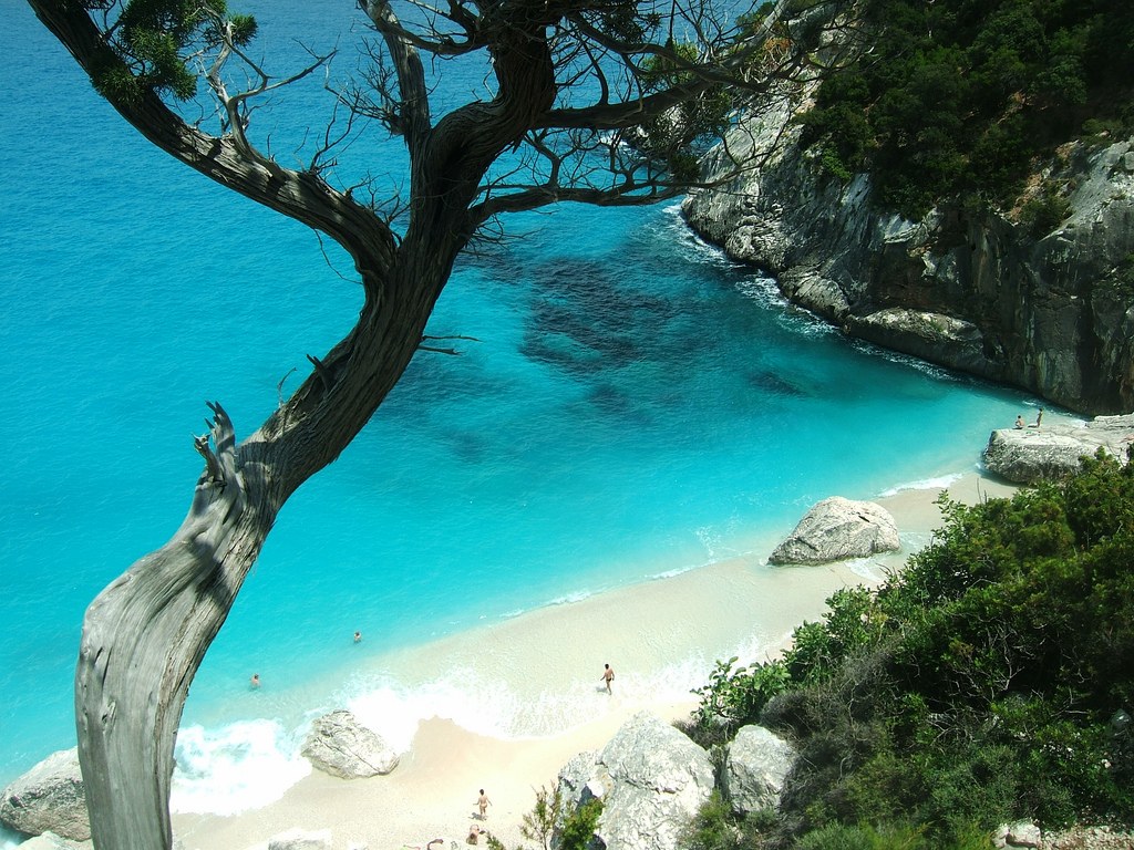
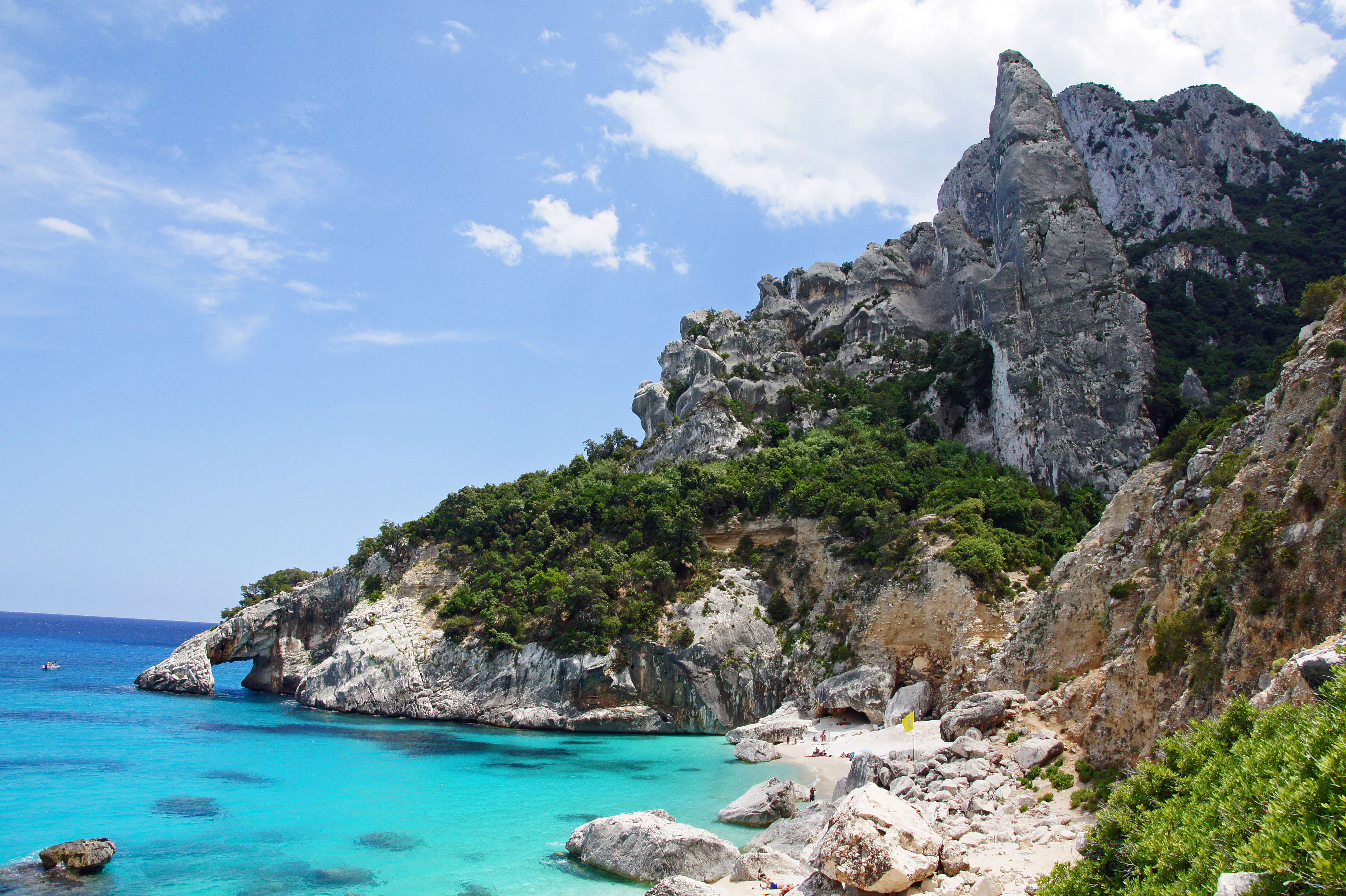
Cala Goloritzè is a cove on the southern edge of the Gulf of Orosei, in the municipality of Baunei, in the Ogliastra region of central-eastern Sardinia. It is younger than most of the people who walk to it. The beach did not exist in its present form until 1962, when a landslide broke loose from the limestone wall above and dropped rock and white gravel into the sea. The slide left behind the cove's two defining features at once: the pale pebble strand at the waterline and, beside it, a 143-meter limestone spire that the slide separated from the cliff face.

That spire is the Aguglia di Goloritzè, also called Punta Caroddi. It rises straight out of the slope at the south end of the beach, narrow and freestanding, and it has been a destination for climbers since 1981. Out in the water on the right side of the bay there is a second piece of the same geology: a natural arch of limestone the sea has cut through. The rock is what people photograph; the swimming, in clear cold water over white gravel, is what they stay for.

The authorities recognized the place early. Cala Goloritzè was declared a Natural Monument of the Sardinia Region in 1993 and an Italian national monument in 1995, and it sits inside the wider protected zone of the Gulf of Orosei and Gennargentu. Those designations are not decoration. They are the legal basis for the rules that now govern every visit, and the reason this cove looks the way it does while more accessible Sardinian beaches have been worn down.

Getting there is the hard part, and it is deliberately hard. There is no road to the beach. You start at the Su Porteddu trailhead on the Golgo plateau above Baunei and walk a marked path of roughly 3.5 kilometers down into the cove, a descent of around 470 meters that takes most people about an hour and a half on the way down and longer coming back up. There is no shade on much of it, no water, and no facilities at the bottom. Sturdy shoes are not a suggestion. You can also arrive by sea, but boats are not permitted to land, and motorized traffic is barred within about 200 meters of the shore.

Since 2021 the cove has been rationed. Visitors must book a slot in advance, the daily number is capped, and there is an entry fee. The system is run for the Comune di Baunei through the Heart of Sardinia booking platform: a maximum of 250 people at the beach at one time, a fee of 7 euros per person, free for children under six, with the fee covering guarded parking at the trailhead. Reservation is required across the season, roughly April through October.

In April 2025 the cove was named the best beach in the world by The World's 50 Best Beaches, a ranking voted by more than a thousand travel-industry professionals. The award put a place that already limits its own crowds onto every list at once. The tension between the cove's fame and the cap that protects it is the real subject here, and it is not resolved.

The spike

A 1962 landslide built this cove and left a 143-meter spire; today a 250-person daily cap rations who may stand in it.

Most famous beaches are old. Cala Goloritzè is not. The cove that voters named the best beach in the world in 2025 did not exist in its present shape until 1962, and the thing that made it was a disaster. In that year a landslide tore loose from the limestone wall on the southern rim of the Gulf of Orosei and fell into the sea. The collapse did two things at once that together define the place. It dumped a fan of pale rock and white gravel at the waterline, creating the beach. And it severed a slender column of limestone from the cliff face, leaving it standing alone: the Aguglia di Goloritzè, also called Punta Caroddi, 143 meters of freestanding rock that now dominates every photograph anyone takes here. The arch in the water on the right side of the bay is cut from the same karst. The beach, the spire, and the arch are not three attractions. They are three pieces of one rockfall, and the cove is essentially a wound in the cliff that the sea filled in and made beautiful.

That origin matters because it explains the rules. A landslide-built cove is, by definition, sitting below a wall that has already proven it can fail, on soft limestone that erodes along its bedding planes. The deposit of gravel is finite and fragile; it is not replenished by any river, only redistributed by the sea. So when Italy moved to protect the place, it moved early and seriously. Cala Goloritzè was declared a Natural Monument of the Sardinia Region in 1993 and an Italian national monument in 1995, and it lies within the wider protected belt of the Gulf of Orosei and Gennargentu. These are not honorary titles. They are the legal foundation for everything that now constrains a visit, and the reason this cove still looks pristine while easier-to-reach Sardinian beaches have been compacted and eroded by their own crowds.

The second half of the spire's story is human, and it belongs to climbing. The Aguglia is one of the most admired rock structures in Italy, a clean blade of high-quality limestone rising straight out of turquoise water, and climbers found it fast. On a cold, windy December day in 1981, Maurizio Zanolla, the legendary free climber known as Manolo, and Alessandro Gogna made the first ascent via a route they called Sinfonia dei Mulini a Vento, the symphony of windmills, which remains the spire's normal line. In 1995 Maurizio Oviglia opened Sole Incantatore, which became one of the best-loved routes on the pinnacle and was rebolted by Oviglia and Enrico Barca in May 2020. And in mid-October 2023, the German alpinist Alexander Huber free-soloed the Aguglia, climbing the spire ropeless via its easiest line, Easy Gymnopedie, at difficulties up to 6b. The pinnacle that a landslide created has, in four decades, accumulated a climbing history as distinct as the beach's own.

But the part of Cala Goloritzè that makes it a genuine outlier among world-famous beaches is not the geology or the climbing. It is the conservation model, and specifically the cap. Since 2021 you cannot simply walk down to this beach. The Comune di Baunei rations access. You must reserve a slot in advance through the official Heart of Sardinia platform, available as an app and a website; the number of people allowed on the sand at any one time is capped at 250; and there is a fee of 7 euros per person, free for children under six, which also pays for guarded parking at the trailhead. Reservation is required across the open season, roughly April through October. This is rare. Plenty of beaches are hard to reach, but very few of the world's celebrated ones put a hard ceiling on how many human beings may be present and charge admission to enforce it. Cala Goloritzè does, and it treats that ceiling as the price of survival.

The access itself reinforces the rationing. There is no road to the cove and there never will be. The land route begins at the Su Porteddu trailhead on the Golgo plateau above Baunei and runs about 3.5 kilometers each way, descending roughly 470 meters into the cove, mostly without shade, on a path that takes about ninety minutes down and considerably longer to climb back out. At the bottom there is nothing: no bar, no kiosk, no fresh water, no lifeguard. Everything a visitor drinks or eats has to be carried in, and the climb out in July heat is where people get into trouble. You can arrive by sea, but boats are forbidden from landing on the beach, and motorized craft must stay roughly 200 meters offshore. The result is a cove you can only enter on foot or by swimming in from an anchored boat, having first paid for and reserved the right to do so.

The tension in all of this came to a head in April 2025, when The World's 50 Best Beaches, a ranking decided by the votes of more than a thousand travel-industry professionals, named Cala Goloritzè the single best beach on the planet, ahead of Entalula in the Philippines and Bang Bao in Thailand. The criteria the panel weighed included untouched nature and the absence of overcrowding, which is precisely what the cap exists to manufacture. So the award is also an endorsement of the restriction: the beach won partly because it limits itself. That is the honest, slightly uncomfortable lesson of Cala Goloritzè. It is a young beach, made by a falling cliff, that became the most coveted shoreline in the world by refusing to let everyone in. The 1962 landslide built it. The 250-person cap is what keeps it worth the walk.

Cala Goloritzé 3.JPG
Culture

Where it shows up

History
  • First ascent of the Aguglia (Sinfonia dei Mulini a Vento) · 1981
    Maurizio Zanolla (Manolo) and Alessandro Gogna

    The 1981 first ascent of the Aguglia di Goloritzè by Manolo and Gogna via Sinfonia dei Mulini a Vento opened the spire to climbing and remains the normal route. It established the pinnacle as one of the finest rock structures in Italy.

Other
  • Sole Incantatore and the climbing development of the spire · 1995
    Maurizio Oviglia

    Oviglia's 1995 route Sole Incantatore became one of the best-known lines on the Aguglia and is regularly cited in climbing media; it was rebolted and restored by Oviglia and Enrico Barca in May 2020.

  • Alexander Huber's 2023 free solo · 2023
    Alexander Huber

    The German alpinist's October 2023 ropeless ascent of the Aguglia via Easy Gymnopedie (up to 6b) drew international climbing coverage and reinforced the spire's status as an icon of Sardinian rock.

  • World's Best Beach 2025 · 2025
    The World's 50 Best Beaches

    In April 2025 a panel of more than 1,000 travel professionals voted Cala Goloritzè the number-one beach in the world, ahead of Entalula (Philippines) and Bang Bao (Thailand), citing its spire, water clarity, and conservation.

Cala Goloritze o.jpg
History

What happened here

  1. 1962natural

    A landslide forms the cove

    A landslide breaks from the limestone wall above and deposits rock and white gravel into the sea, creating the beach in its present form and separating the 143-meter spire later known as the Aguglia from the cliff face.

    Wikipedia →
  2. 1981cultural

    First ascent of the Aguglia

    On a cold, windy December day Maurizio Zanolla (Manolo) and Alessandro Gogna make the first ascent of the Aguglia di Goloritzè via the route Sinfonia dei Mulini a Vento, still considered the normal route up the spire.

  3. 1993policy

    Declared a Natural Monument of Sardinia

    The Sardinia Region designates Cala Goloritzè a Natural Monument, the first formal protection of the cove and its spire.

    Wikipedia →
  4. 1995policy

    Declared an Italian national monument

    Cala Goloritzè is designated an Italian national monument, extending its protected status to the national level.

    Wikipedia →
  5. 1995cultural

    Sole Incantatore opened on the spire

    Climber Maurizio Oviglia establishes Sole Incantatore on the Aguglia, which becomes one of the most popular and admired routes on the pinnacle; Oviglia and Enrico Barca rebolt and restore it in May 2020.

  6. 2021policy

    Booking system and daily cap introduced

    The Comune di Baunei introduces mandatory advance reservation, a daily visitor cap of 250 people on the beach at a time, and a per-person entry fee, administered through the Heart of Sardinia platform to manage crowds and protect the Natural Monument.

  7. 2023cultural

    Alexander Huber free-solos the Aguglia

    German climber Alexander Huber free-solos the Aguglia di Goloritzè in mid-October via Easy Gymnopedie, the easiest line on the spire, at difficulties up to 6b, climbing it without a rope.

  8. 2025cultural

    Named the best beach in the world

    The World's 50 Best Beaches, a ranking voted by more than 1,000 travel-industry professionals, names Cala Goloritzè the number-one beach in the world for 2025, citing its limestone spire, clear water, and conservation.

The honest part
The cap and the fee are how a Natural Monument survives being named the best beach in the world.

The honest part of Cala Goloritzè is that it is administered, not just visited. Since 2021 you cannot simply show up. You book a slot on an app, you pay 7 euros, and you are one of at most 250 people allowed on the sand at a time. To some visitors that feels like a beach turned into a ticketed attraction, and the fee has drawn complaints from people who believe an Italian coastline should be free to reach. To the Comune di Baunei, which runs the system, the cap and the fee are how a Natural Monument survives being named the best beach in the world: the gravel is fragile, the cove is small, and the landslide that built it in 1962 is a reminder that this wall still moves.

The protection is real and it is restrictive. Boats may not land. Motorboats must stay roughly 200 meters offshore. There is no kiosk, no bar, no shade structure, no fresh water, and no lifeguard at the bottom of the trail. The 3.5-kilometer path in is steep, exposed, and unforgiving on the climb out in summer heat, and people are rescued from it every season for underestimating it. The cove rewards the effort, but it does not soften it, and the rules that keep it beautiful are the same rules that make it inconvenient on purpose.

Cala Goloritzé 1.JPG
Anatomy

The shape of the place

The sea arch

20%

The natural limestone arch on the right side of the bay, cut by the sea, reachable by swimming out from the strand on calm days.

Best for Snorkeling and short swims

Stay clear of any boat traffic beyond the 200-meter motor-free zone.

The pebble strand

50%

The cove's white-gravel-and-pebble beach, the deposit left by the 1962 landslide, dropping into clear, cold, fast-deepening water. No shade, no facilities, capped at 250 people at a time.

Best for Swimming in clear water

Everything you eat or drink must be carried in; nothing is sold here.

Su Porteddu descent

50%

The marked footpath from the Su Porteddu trailhead on the Golgo plateau down to the cove, about 3.5 kilometers and roughly 470 meters of descent, mostly unshaded.

Best for The only land access

Sturdy shoes essential; the climb back out in summer heat is the hard part.

Base of the Aguglia

80%

The foot of the 143-meter limestone spire at the south end of the cove, where climbing routes start. The pinnacle rises freestanding from the slope and dominates every view of the beach.

Best for Climbers and the defining photograph

Climbing is for experienced parties only; the rock is high-quality limestone but committing.

Landmarks

Aguglia di Goloritzè (Punta Caroddi)

natural

The freestanding limestone spire at the south end of the cove, 143 meters high, separated from the cliff by the 1962 landslide. A celebrated sport-climbing pinnacle first climbed in 1981 by Manolo and Alessandro Gogna and free-soloed by Alexander Huber in 2023, it dominates every view of the beach.

Wikipedia →

The sea arch

natural

A natural limestone arch on the right side of the bay, cut through by the sea, part of the same karst formation that shaped the cove. Reachable by a short swim from the strand on calm days.

Wikipedia →
A day here

From first light to dark

Dawn

The trail opens early and the first walkers leave Su Porteddu before the heat, descending through juniper and limestone with the cove still in shadow below them. At the bottom the water is glass-flat and the Aguglia catches the first light on its east face while the beach stays cool and nearly empty.

Midday

By late morning the 250-person cap is close to full and the cove is at its loudest, the white gravel hot underfoot and the water lit to its full turquoise. There is no shade to retreat to, so people crowd the waterline and the few rocks. Climbers may be visible high on the Aguglia, small against the spire.

Golden hour

Late afternoon thins the crowd as walkers leave early enough to climb the 470 meters back to the plateau before dark. The light warms the limestone and the arch offshore, and the cove quiets toward the closing of the trail.

Night

After the trail closes the cove is empty and unlit, with no facilities and no one staying. The plateau above is dark-sky country; the beach below belongs to the water moving over gravel and the spire standing black against the stars.

Compare

How it ranks

Peak warmth
Cooler than 91% of beaches in its country
Peak-month high ≈ 27°C

Ranked against every beach in our database — 228,000+ worldwide.

Cala Goloritzé 5.JPG
Sea & surf

What the water does

JFMAMJJASONDmetres (significant wave height)

Solid = typical monthly wave height; pale = the bigger days (90th pct). Offshore/regional swell from Open-Meteo Marine (ERA5 Ocean reanalysis, 2023–2024); a sheltered cove may sit calmer than this.

Mixed — usually swimmable, with a livelier season
Typical wave height
0.72 m
Biggest swell
Dec · 1 m
Calmest
Aug · 0.4 m
Typical period
4.9 s (wind chop)
Before you go

Things to know

Book ahead

Reservation is mandatory in season (about April-October) through the Heart of Sardinia platform; only 250 people are allowed on the beach at a time, and the fee is 7 euros per person (free under six).

The hike is the access

There is no road. From the Su Porteddu trailhead it is roughly 3.5 km each way with about 470 meters of descent and a hard climb back out. Wear sturdy shoes and allow about 90 minutes down, more up.

No facilities

No shade, no fresh water, no bar, no lifeguard at the cove. Carry all the water and food you need, and protect against sun on the exposed trail.

No boat landing

Boats may not land on the beach and motorized craft must stay roughly 200 meters offshore. Arriving by sea means swimming in, not stepping ashore from a boat.

Sharks

No incidents on record in the global shark-attack file.

Lifeguard

No lifeguard service — swim within your limits.

Plan

If you go

Getting there
Nearest airport
Olbia Costa Smeralda Airport (OLB) · 89 km
Nearest town
Baunei · 9 km

There is no road to Cala Goloritzè. The land route starts at the Su Porteddu trailhead on the Golgo plateau above Baunei and follows a marked path of about 3.5 km each way, descending roughly 470 meters to the cove (about 90 minutes down, longer back up). Reservation through the Heart of Sardinia platform is mandatory in season; parking at the trailhead is guarded and included in the 7-euro fee. Boats may approach but not land, and must stay about 200 meters offshore.

When to go
  • Reservation season · Roughly April through October

    Advance booking through the Heart of Sardinia platform is mandatory across the open season, with the 250-person daily cap and 7-euro fee in force. Outside this window the trail and beach see far fewer people and the formal system winds down.

  • Climbing season on the Aguglia · Spring and autumn, avoiding summer heat

    Climbers favor the cooler shoulder months to attempt routes on the spire, from the 1981 normal route to harder modern lines. Access to the wall is via the same capped, fee-based beach trail.

What to eat & drink
Nothing at the beach

There is no bar, kiosk, or fresh water at Cala Goloritzè and nothing is sold on the sand. You must carry in everything you will drink and eat for a half-day round trip that includes a 470-meter climb out. Pack more water than you think you need.

Carry it from the trailhead; nothing for sale below

Pane carasau and Ogliastra pecorino

The thin, twice-baked Sardinian flatbread that keeps for days and the local sheep's-milk pecorino are the regional walking food, sold in Baunei and Santa Maria Navarrese shops. They predate tourism and travel well in a pack.

Bakeries and alimentari in Baunei village

Culurgiones

Ogliastra's signature stuffed pasta, hand-pleated pockets filled with potato, pecorino, and mint, is a protected regional specialty (PGI) most associated with this exact part of Sardinia. Eat it before or after the hike, in a Baunei or Tortolì trattoria.

Trattorias in Baunei and the Ogliastra coast

Cannonau di Sardegna

Sardinia's dominant red wine, made from the Cannonau (Grenache) grape, is the standard table wine of Ogliastra and a regional staple rather than a tourist product. Reserve it for after the climb, not the trail.

Restaurants and shops across Ogliastra

Sources & references
  1. Wikipedia: Cala Goloritzè · cited 5×
  2. PlanetMountain · cited 4×
  3. Life in Sardegna; immobiliare.it · cited 2×
  4. The World's 50 Best Beaches; The Local Italy · cited 2×
  5. Wikipedia: Cala Goloritzè; World's 50 Best Beaches
  6. Costa di Baunei; Life in Sardegna
  7. Life in Sardegna; The Wom Travel
Colophon · Provenance

Where this page comes from

Geography, facilities
OpenStreetMap (ODbL) for geometry and facility tags within 500 m of the beach centroid. GeoNames for city/airport distances.
Climate & ocean
worldclim_v2.1_2.5m
Tides
eot20
Photography
Archival, original tone (Tier B — Wikimedia Commons). Each image licensed per its own terms; attribution visible inline.
History & culture
Every factual claim is linked to its source in the prose above. Wikipedia citations inline. Non-wiki sources named where relevant.
Editorial voice
Register: reverent. Written to pass a local's nod test; corrections welcome.
Written by Erin Rose
Last reviewed 2026-04-19
v0.9in editorial development toward v1.0