Balearic Islands, ES

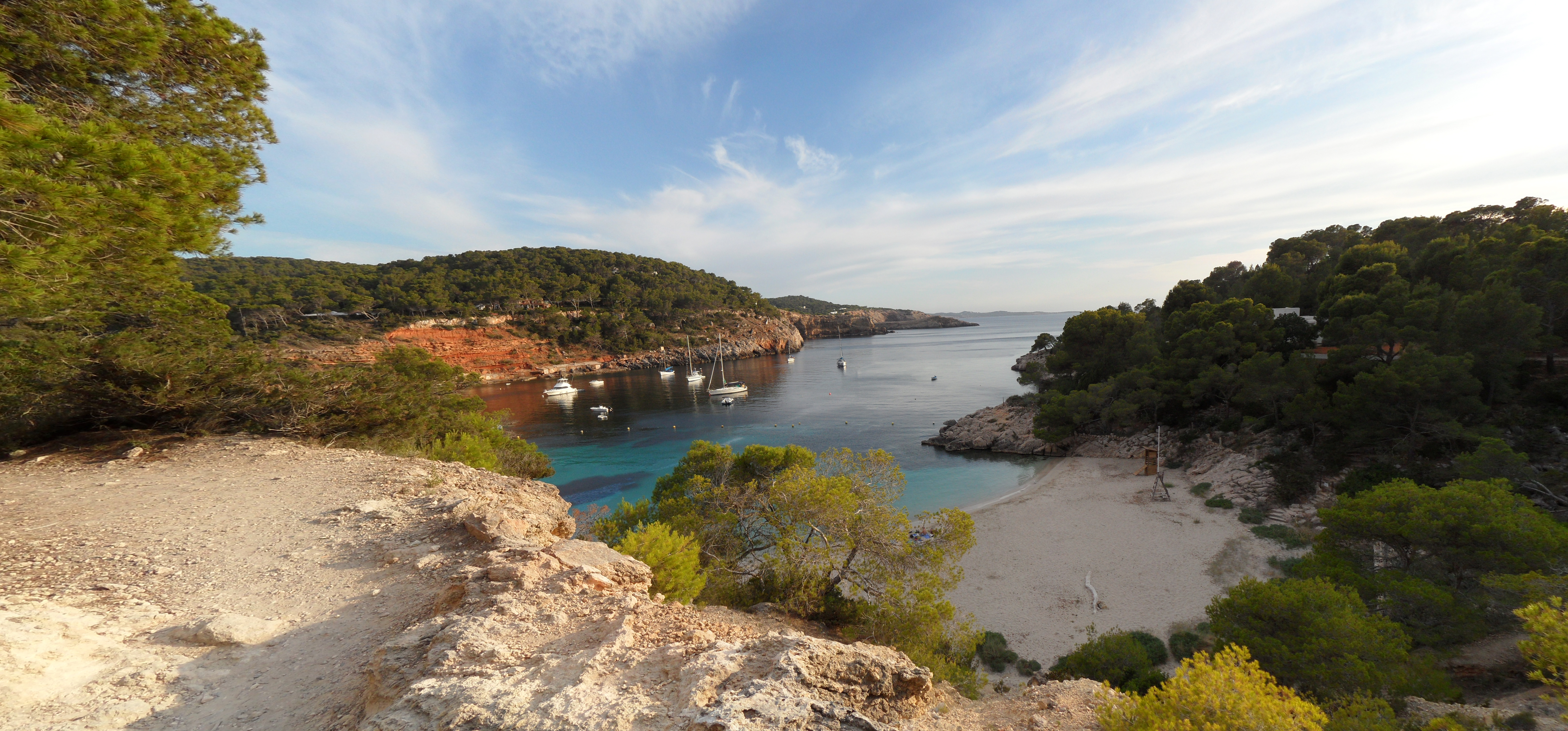
Cala Salada

Eivissa - Cala Salada.jpg

Balearic Islands, ES

Cala Salada

Since 2016 Sant Antoni has run buses and boats to Cala Salada; since 2023 a €113,176-a-year contract has gated the road, citing extreme wildfire risk.

Eivissa - Cala Salada.jpg · Enrique Ayesta Perojo · CC BY-SA 4.0
Substrate
pebble
Nearest airport
IBZ · 17 km
Story

Cala Salada is a pebble cove on the west coast of Ibiza, in the municipality of Sant Antoni de Portmany. Wikipedia places it 4.7 km (2.9 mi) north of the town of Sant Antoni de Portmany; the Spain Film Commission's location listing gives a shorter 4 km for the same distance. Immediately alongside it sits the smaller Cala Saladeta — a separate beach, not another name for the same cove. The mid-20th-century building known as Casa Rosada physically divides the two. Cala Salada is the developed half: it has a restaurant, lifeguards, toilets and disabled access. Cala Saladeta is sandy, has no facilities of its own, and, per Ibiza Spotlight, gets very busy in summer, especially on weekends.

Sources disagree on how big the beach actually is. Wikidata lists Cala Salada at 75 metres long by 20 metres wide. Ibiza Spotlight puts the wider bay at 200 metres long and 5 to 30 metres wide; Barceló gives Cala Salada alone as 200 metres long and about 25 metres wide, "depending on the tides." The gap suggests the 200-metre figures describe the combined Salada-Saladeta bay rather than Cala Salada by itself. What the sources agree on: sunbeds, parasols, and showers that have been turned off to save water. The road down ends at a small, shaded car park with 65 spaces, with stairs to the sand; the beach's one restaurant, at a corner of Cala Salada, is popular with locals for seafood paella and other Ibizan-style dishes.

Getting there without a car is not an accident. Sant Antoni's town hall began a bus-and-boat program at Cala Salada in 2016 — later expanded island-wide to 30 beaches in 2017 — and since 2023 has also run a separate, paid vehicle checkpoint that gates the access road itself; both are covered in full in the history deep dive below. The stated reason for the checkpoint is blunt: the town hall classifies the Cala Salada/Cala Saladeta zone as an area of extremely high wildfire risk.

Cala Salada marks the start of the Es Amunts nature reserve, running along Ibiza's northern coast to Sant Carles. The rocky, Posidonia-covered ground offshore is habitat for the ornate wrasse, found at depths of 0 to 50 metres and rated Least Concern by the IUCN. The coast also retains a handful of escars, traditional dry docks for fishing boats, among the pines. Our own site data rates this stretch "1 - excellent" (EU bathing-water station ES531M0461202); more broadly, the EU's 2025 bathing-water report rated 85% of roughly 22,000 monitored coastal sites "excellent."

There is no confirmed 2026-season price for the bus, boat, or parking — the fares on record (€9 adult/€4.5 child round trip, a bus every 15 minutes) date to the 2016-17 rollout. The restaurant's actual name, menu and prices weren't retrievable, so it's described here only as the restaurant at Cala Salada. And one travel guide, Barceló, tells visitors flatly there is no public transport to Cala Salada — a claim the town hall's own program, running every summer since 2016, directly contradicts.

The spike

Since 2016 Sant Antoni has run buses and boats to Cala Salada; since 2023 a €113,176-a-year contract has gated the road, citing extreme wildfire risk.

Cala Salada photographs as an escape: a pine-backed pebble cove that tourism writers describe as one of the least developed stretches of coastline on Ibiza's west side. What that framing leaves out is that a good part of the beach's calm is not organic. It is administered, on a public contract, by the same town hall that markets the cove as untouched.

Two separate programs, not one. The first goes back to 2016, when Sant Antoni de Portmany's town hall and the Consell d'Eivissa designed "Playa Conectada," a sustainable-mobility pilot that restricted private-car access to Cala Salada from 1 June to 30 September and replaced it with a scheduled bus and a port boat. Cars have been barred from the access road between 10:00 and 18:00 under that scheme since it began. The bus ran every 15 minutes in both directions, from a 9:30 first departure at Sant Antoni to a 20:30 last departure from the beach; a round-trip boat ticket cost 9 euros for adults and 4.5 euros for children aged 7 to 12. The pilot worked well enough that it expanded island-wide to 30 beaches the following year, 2017. A later account of the same corridor, from Ibiza Spotlight, describes a minibus, line P7, running every 30 minutes from 9:30 to 20:30 with a park-and-ride stop at the Can Coix sports centre — a second, later layer over the original bus-and-boat design.

Then a second, harder layer arrived. Starting in 2023, Sant Antoni's town hall added a paid vehicle checkpoint — a literal access-control service, not just a scheduled alternative to driving. The contract is worth 113,176.02 euros a year, VAT included, and as reported in 2024 runs for two years with an option to extend for two more. The town hall's stated justification is not congestion or aesthetics: it classifies the Cala Salada/Cala Saladeta access zone as an area of extremely high wildfire risk, and the checkpoint exists to keep the road clear for emergency access. In the 2026 season the checkpoint runs daily, uninterrupted, from 9:30 to 17:00. Motorcycles, bicycles, vehicles for people with reduced mobility, taxis, and local residents or workers are exempt; everyone else's car is turned back. In 2024 — two years before that 2026 reactivation — the town hall also built a signposted, roughly 500-metre pedestrian path from the first car park down to the beach, specifically so bathers would not have to walk the access road itself.

The contradiction that exposes the marketing. Barceló, a hotel operator with its own visitor guide to the island, tells readers flatly that there is no public transport that leads to Cala Salada, and recommends a taxi from Sant Antoni instead. That is not a small error. It contradicts a program the town hall itself has run, continuously, every summer since 2016 — one detailed enough to publish its own bus timetable and boat fares, and specific enough that Ibiza Spotlight independently confirmed a functioning minibus line years later. If a professional travel guide cannot establish whether public transport to a named beach exists, the sense of remoteness that guides like Barceló otherwise sell about Cala Salada is worth a second look. The beach is not undiscovered. It is gated — by schedule, by checkpoint, and, for at least one guidebook, by a simple failure to check.

What this buys, and what it costs. The mechanics are not subtle once laid out: a beach with 65 parking spaces and one restaurant cannot absorb unlimited car traffic down a narrow access road in a wildfire-risk pine forest, so the town hall pays roughly 113,176 euros a year to physically prevent it, on top of running a bus and boat since 2016. That is a defensible piece of public safety and traffic engineering. It is also the actual mechanism behind the peaceful, uncrowded cove that tourism copy sells — a mechanism that costs real public money every year, that most visitors never see priced anywhere, and that at least one major travel brand appears not to have checked before publishing advice that flatly denies it exists. Add the checkpoint's 113,176.02 euros to whatever the bus-and-boat program has cost the town hall annually since 2016, and Cala Salada's reputation for quiet, uncrowded pebble and pine is one of the more expensive pieces of ambient scenery on the island, funded every season out of the same public budget that pays for the road crews, the lifeguards, and the pedestrian path built in 2024.

Cala Salada, near Sant Antoni.jpg
History

What happened here

  1. 2016policy

    Playa Conectada pilot launches at Cala Salada

    Sant Antoni's town hall and the Consell d'Eivissa pilot a sustainable-mobility program restricting private cars and running a bus and boat instead.

  2. 2017policy

    Program expands to 30 beaches island-wide

    The Cala Salada pilot, having gone well, expands across Ibiza to 30 beaches under the same Playa Conectada model.

  3. 2017access

    New number-34 bus line noted in a beach review

    A February 2017 review flags a newly introduced number-34 bus running regularly from Sant Antoni, expected to sharply increase visitor volume to both coves.

  4. 2023governance

    Vehicle checkpoint contract begins

    A separate, paid access-control service starts gating the road to Cala Salada and Cala Saladeta, worth 113,176.02 euros a year, VAT included.

  5. 2024governance

    Contract terms confirmed: two years plus option

    Reporting confirms the 2023 checkpoint contract runs two years with an option to extend for two more.

  6. 2024access

    Pedestrian path built to the beach

    The town hall builds a signposted, roughly 500-metre pedestrian path from the first car park to the sand, so bathers avoid walking the access road.

  7. 2026governance

    Checkpoint reactivated for the season

    The 2026-season checkpoint resumes, running daily and uninterrupted from 9:30 to 17:00, citing the zone's extreme wildfire risk.

Ibiza-plage.jpg
Anatomy

The shape of the place

Car park and pedestrian path

5%

A small, shaded 65-space car park with stairs down to the sand, plus a signposted, roughly 500-metre pedestrian path built in 2024.

Best for Where the vehicle checkpoint is enforced

Cala Salada main beach

30%

The pebbly, developed cove with sunbeds, parasols, a restaurant, lifeguards, toilets and disabled access.

Best for Swimming and the on-site restaurant

Showers are present but turned off to save water.

Cala Saladeta

70%

The smaller sibling cove, sandy, reached by a rocky path, with no facilities of its own and heavy summer crowding.

Best for Sand rather than pebbles

Divided from Cala Salada by the mid-20th-century Casa Rosada building.

Es Amunts reserve edge

90%

Cala Salada marks the southern start of the Es Amunts nature reserve, which runs up Ibiza's northern coast to Sant Carles.

Best for The pine coastline and offshore Posidonia beds

Landmarks

Casa Rosada

building

A mid-20th-century building that physically divides Cala Salada from Cala Saladeta; no primary source for its construction date or original purpose was found.

Es Amunts nature reserve

nature reserve

Cala Salada marks the start of this reserve, which extends along Ibiza's northern coast up to Sant Carles.

A day here

From first light to dark

Dawn

Before 9:30, the vehicle checkpoint has not opened for the day and the access road is at its quietest; anyone already parked in the 65-space car park has the pebble crescent close to themselves before the restaurant sets up.

Midday

By midday the checkpoint has been running for hours, the restaurant at the corner of the beach is serving seafood paella to a mix of locals and day-trippers, and the bus and boat from Sant Antoni are both mid-schedule.

Golden hour

Late afternoon is the hinge point: the 2026-season checkpoint closes at 17:00, but from 1 June to 30 September the separate Playa Conectada car restriction still bars private cars from the access road until 18:00 — so the light has already turned gold over the pines before cars can actually filter back down, and the last scheduled bus and boat departures, at 20:30, are still hours off.

Night

After the 20:30 last departures, Cala Salada has no confirmed lifeguard or checkpoint staffing; the road reverts to open access until the checkpoint reopens the next morning at 9:30.

Location map Ibiza.png
Culture

Where it shows up

History
  • Escars: traditional boat dry docks

    The coast at Cala Salada retains some escars, traditional dry docks for small fishing boats, among the pine surroundings.

Brand & advertising
  • Barceló's "no public transport" claim
    Barceló Experiences

    Barceló's visitor FAQ tells readers there is no public transport to Cala Salada and recommends a taxi — a claim the town hall's own bus-and-boat program directly contradicts.

  • White Ibiza's "unscathed" framing · 2026
    White Ibiza

    White Ibiza's guide frames Cala Salada as a rustic beach relatively unscathed by the overdevelopment of neighbouring areas, busy from lunchtime in July-August but quiet the rest of the season.

Other
  • Ornate wrasse habitat

    The ornate wrasse, found on rocky ground with algae and Posidonia seagrass at depths of 0 to 50 metres, matches the habitat offshore of Cala Salada.

The honest part
“The beach is not undiscovered. It is gated — by schedule, by checkpoint, and, for at least one guidebook, by a simple failure to check.”

The sense of remoteness sold by beach guides for Cala Salada is doing work that a public contract is actually performing. Since 2016 Sant Antoni's town hall has run a scheduled bus and boat to keep cars off the access road in summer; since 2023 it has paid a separate operator 113,176.02 euros a year, VAT included, to physically staff a checkpoint on that same road, citing the zone's extremely high wildfire-risk classification. None of that is secret — the town hall publishes it — but it is not what most visitor-facing copy describes either.

The confusion runs both directions. Barceló's own visitor FAQ claims no public transport reaches Cala Salada at all, a claim the town hall's program directly contradicts, and one that would send a car-less visitor toward an unnecessary taxi. The honest picture is a beach whose calm is managed, priced, and occasionally misdescribed by the businesses paid to describe it accurately.

Eivissa - Cala Saladeta.jpg
Sea & surf

What the water does

JFMAMJJASONDmetres (significant wave height)

Solid = typical monthly wave height; pale = the bigger days (90th pct). Offshore/regional swell from Open-Meteo Marine (ERA5 Ocean reanalysis, 2023–2024); a sheltered cove may sit calmer than this.

Mixed — usually swimmable, with a livelier season
Typical wave height
0.82 m
Biggest swell
Jan · 1.23 m
Calmest
Jul · 0.51 m
Typical period
5.5 s (wind chop)
Before you go

Things to know

Two access-control layers

A 1 June-30 September car restriction (10:00-18:00) with a substitute bus and boat has run since 2016; since 2023 a separate €113,176.02-a-year checkpoint contract has also gated the road, citing extreme wildfire risk. In the 2026 season the checkpoint runs daily, 9:30-17:00.

Who's exempt from the checkpoint

Motorcycles and bicycles, mobility-impaired vehicles, taxis, and local residents or workers are exempt from the vehicle restriction; everyone else's car is turned back during checkpoint hours.

Facilities

Sunbeds, parasols, a restaurant, lifeguards, toilets and disabled access are present at Cala Salada; showers are installed but turned off to save water. Cala Saladeta next door has none of this.

Public transport does exist

Despite one travel guide's claim to the contrary, Sant Antoni has run a scheduled bus (every 15 minutes, 9:30-20:30) and a port boat (round trip €9 adult/€4.5 child) to Cala Salada every summer since 2016, plus a later P7 minibus every 30 minutes.

Sharks

No incidents on record in the global shark-attack file.

Plan

If you go

Getting there
Nearest airport
Ibiza Airport (IBZ) · 17 km
Nearest town
Sant Antoni de Portmany · 3 km

Cala Salada sits on Ibiza's west coast, in the municipality of Sant Antoni de Portmany — 4.7 km (2.9 mi) north of the town by Wikipedia's measure, 4 km by the Spain Film Commission's. By car from Ibiza Town, Barceló gives roughly 20 km via the C-731 and PM-812 roads, about 25 minutes; no verified road distance or drive time from Ibiza Airport was found in our research. From 1 June to 30 September, private cars are barred from the access road between 10:00 and 18:00; a bus (every 15 minutes, 9:30-20:30) and a port boat (round trip €9 adult/€4.5 child ages 7-12, 2016-17 fares) run instead, alongside a later P7 minibus (every 30 minutes, 9:30-20:30) with park-and-ride at the Can Coix sports centre. Since 2023, a separate paid checkpoint additionally gates the road; in the 2026 season it runs daily, uninterrupted, 9:30-17:00, exempting motorcycles, bicycles, mobility vehicles, taxis, and local residents or workers. A 65-space car park and a signposted, roughly 500-metre pedestrian path (built 2024) connect to the sand.

When to go
  • Summer car-access restriction (Playa Conectada) · 1 June - 30 September, cars barred 10:00-18:00

    The original 2016 mobility pilot restricts private cars on the access road each summer, running a bus and boat instead.

  • Seasonal vehicle checkpoint · Daily during the 2026 season, 9:30-17:00

    A separate, paid checkpoint contract, running since 2023, physically gates the road each season, citing extreme wildfire risk.

What to eat & drink
The restaurant at Cala Salada

The only beach restaurant, at a corner of Cala Salada, is popular with locals for traditional dishes like seafood paella; a separate account describes an Ibizan-style menu with rice dishes, lobster stew, and grilled fish and meat, run as a family business.

A corner of Cala Salada beach itself

No facilities at Cala Saladeta

The sibling cove next door has no restaurant, kiosk, or facilities of its own; anyone based there walks or scrambles over to Cala Salada for food.

Cala Saladeta, the adjacent cove

Bring your own supplies

Our sources found no second food or drink vendor at either cove beyond the single beachfront restaurant, and its own name, menu and prices were not retrievable from its dedicated listing pages.

Cala Salada / Cala Saladeta

Go deeper
Sources & references
  1. Periódico de Ibiza y Formentera · cited 4×
  2. Tourinews · cited 3×
  3. SeeIbiza
  4. Periódico de Ibiza y Formentera (derived: D01)
  5. Noudiari.es / Periódico de Ibiza y Formentera
  6. Wikipedia: Cala Salada
  7. Wikidata Q5739606
  8. Ibiza Spotlight
  9. Ayuntamiento de Sant Antoni de Portmany
  10. Noudiari.es
Colophon · Provenance

Where this page comes from

Geography, facilities
OpenStreetMap (ODbL) for geometry and facility tags within 500 m of the beach centroid. GeoNames for city/airport distances.
Climate & ocean
Open-Meteo ERA5 + Marine archive, 2014–2023 monthly normals.
Photography
Archival, original tone (Tier B — Wikimedia Commons). Each image licensed per its own terms; attribution visible inline.
History & culture
Every factual claim is linked to its source in the prose above. Wikipedia citations inline. Non-wiki sources named where relevant.
Editorial voice
Register: wry. Written to pass a local's nod test; corrections welcome.
Written by Erin Rose
Last reviewed 2026-04-19
v0.9 — in editorial development toward v1.0