Lower Normandy, FR

Gold Beach

The Blue Marble, AS17-148-22727.jpg

Lower Normandy, FR

Gold Beach

The British D-Day beach whose bay is still filled with the concrete ruins of Port Winston, the artificial harbour that supplied the liberation of Europe.

The Blue Marble, AS17-148-22727.jpg · Harrison Schmitt / Apollo 17 · Public domain
Length
18.0 km
Spring tide
6.49 m
Nearest airport
CFR · 18 km
Tier
Featured
I’m here for
Story

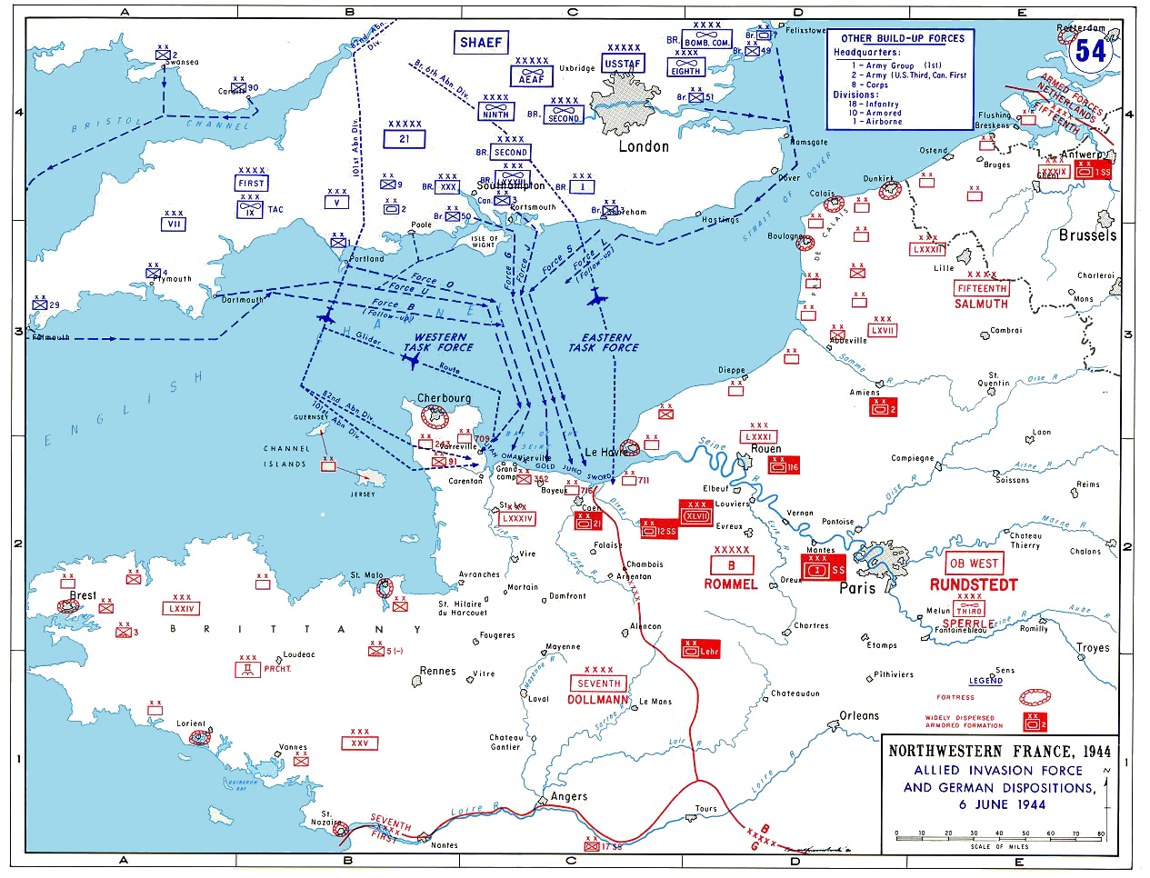
Gold Beach is the central of the five D-Day landing beaches, a stretch of the Calvados coast in Normandy running roughly between Le Hamel and La Rivière, below a low, gentle shore. The name is not French. It was the codename Allied planners assigned this sector for the invasion of 6 June 1944, between American Omaha to the west and Canadian Juno to the east. The communes along it are Arromanches-les-Bains, Asnelles, and Ver-sur-Mer.

The assault was carried by the British 50th (Northumbrian) Infantry Division under Major General Douglas Graham, in the sectors codenamed Jig and King: the 231st Brigade at Le Hamel and Asnelles, the 69th at La Rivière and Ver-sur-Mer. It went better than Omaha. By nightfall 24,970 men had been landed, with around 2,100 vehicles, and the division had pushed inland toward Bayeux. British casualties at Gold on 6 June are usually given as roughly 1,000 to 1,100, of whom about 350 were killed; the 50th Division itself lost on the order of 700. The figures are estimates and sources vary.

The thing that makes Gold singular is not the fighting on the sand. It is what the Allies built in the bay immediately afterward. Off Arromanches they assembled Mulberry "B," a prefabricated artificial harbour towed in pieces across the Channel, because the invasion needed to land supplies before any deep-water port had been captured. When a storm wrecked its American twin off Omaha thirteen days later, this one survived and was renamed Port Winston. It ran for roughly ten months and handled on the order of 2.5 million men, 4 million tons of stores, and half a million vehicles. The concrete caissons that formed its breakwater still stand in the water off Arromanches, walkable to at low tide.

Two other things give Gold its weight. Just west, at Longues-sur-Mer, stands the only German coastal battery in Normandy that still has its guns in their casemates, four 150-millimetre naval pieces that fired on the invasion fleet on D-Day morning. And inland above Ver-sur-Mer, the British Normandy Memorial opened on 6 June 2021, recording the names of the 22,442 men and women under British command killed in Normandy between D-Day and the end of August 1944.

Today Arromanches is a small seaside resort, busy in summer, its seafront looking straight out at the Mulberry ruins; Asnelles and Ver-sur-Mer are quiet flat-sand beaches used by families and sand-yachts. The coast is a working stretch of Norman shoreline and a battlefield landscape at once, and the contradiction is held in plain sight: you can buy an ice cream on the front at Arromanches and look out at the harbour that supplied the liberation of a continent.

The spike

The British D-Day beach whose bay is still filled with the concrete ruins of Port Winston, the artificial harbour that supplied the liberation of Europe.

Most legendary beaches earn the word from nature. Gold Beach earns it from engineering, from a single decision the Allies made before the invasion that changed how this stretch of Norman coast would be remembered: they brought their own harbour with them. The singular fact of Gold is that its bay is still full of the concrete ruins of that harbour, Port Winston, the artificial port that fed the liberation of Europe, and that those ruins sit directly in front of a working seaside resort. You can stand on the seafront at Arromanches in August, with families on the sand and gulls over the front, and look out at a ring of grey caissons in the water that landed two and a half million men.

Start with the problem the harbour solved, because the problem is the whole reason the beach matters. An invasion does not end when the troops are ashore. It is won or lost on supply, on the tonnage of ammunition, fuel, food, and vehicles that can be landed day after day. The Germans understood this and had fortified every deep-water port on the French coast into a fortress; the disastrous Dieppe raid of 1942 had shown that taking a port by direct assault was murderously costly. So the Allies decided not to capture a port at all, at least not at first. They would build two, in Britain, in secret, and tow them across the Channel in pieces after the landings. These were the Mulberry harbours, and Mulberry "B" was assembled here, off Arromanches at the eastern end of the Gold sector, to serve the British and Canadian beaches.

The system was a set of nested breakwaters and floating roads, and it is worth understanding how it actually worked, because the surviving pieces in the bay are not random rubble. The outermost shelter was a line of floating steel breakwaters called Bombardons, anchored offshore to break the worst of the swell. Inside them came the main barrier: lines of massive hollow reinforced-concrete caissons called Phoenixes, built in Britain, floated, towed across, and then deliberately flooded so they sank to the seabed in position, forming a solid concrete breakwater. These are the blocks still standing off Arromanches. Sheltering the inner anchorage further were Gooseberries, old merchant ships and obsolete warships scuttled in a line to make a reef of hulls. Within the calm water this created, Spud pierheads, floating platforms on legs that rested on the seabed and slid up and down with the tide, took the ships, and from them ran the Whales, floating steel roadways on pontoons, carrying lorries the last distance to shore across the huge Norman tidal range. The whole thing was a portable port the size of Dover, dropped onto an open beach.

Then the weather tested it. On 19 June 1944, thirteen days after the landings, the worst Channel storm in decades struck the Normandy coast. It destroyed Mulberry "A," the American harbour off Omaha, beyond repair; most of its caissons were wrecked, and the Americans abandoned it and reverted to landing supplies directly over the open beach. Mulberry "B" at Arromanches, in more sheltered water and more solidly anchored, survived. After the storm it was reinforced with salvaged parts from the dead American harbour, and it became Port Winston, named for Churchill, who had championed the artificial-harbour idea for years. It had been designed to last three months. It ran for about ten, handling on the order of 2.5 million men, 4 million tons of supplies, and 500,000 vehicles before the captured deep-water port of Antwerp took over the supply burden. Those numbers are the reason a quiet resort town is a place of pilgrimage.

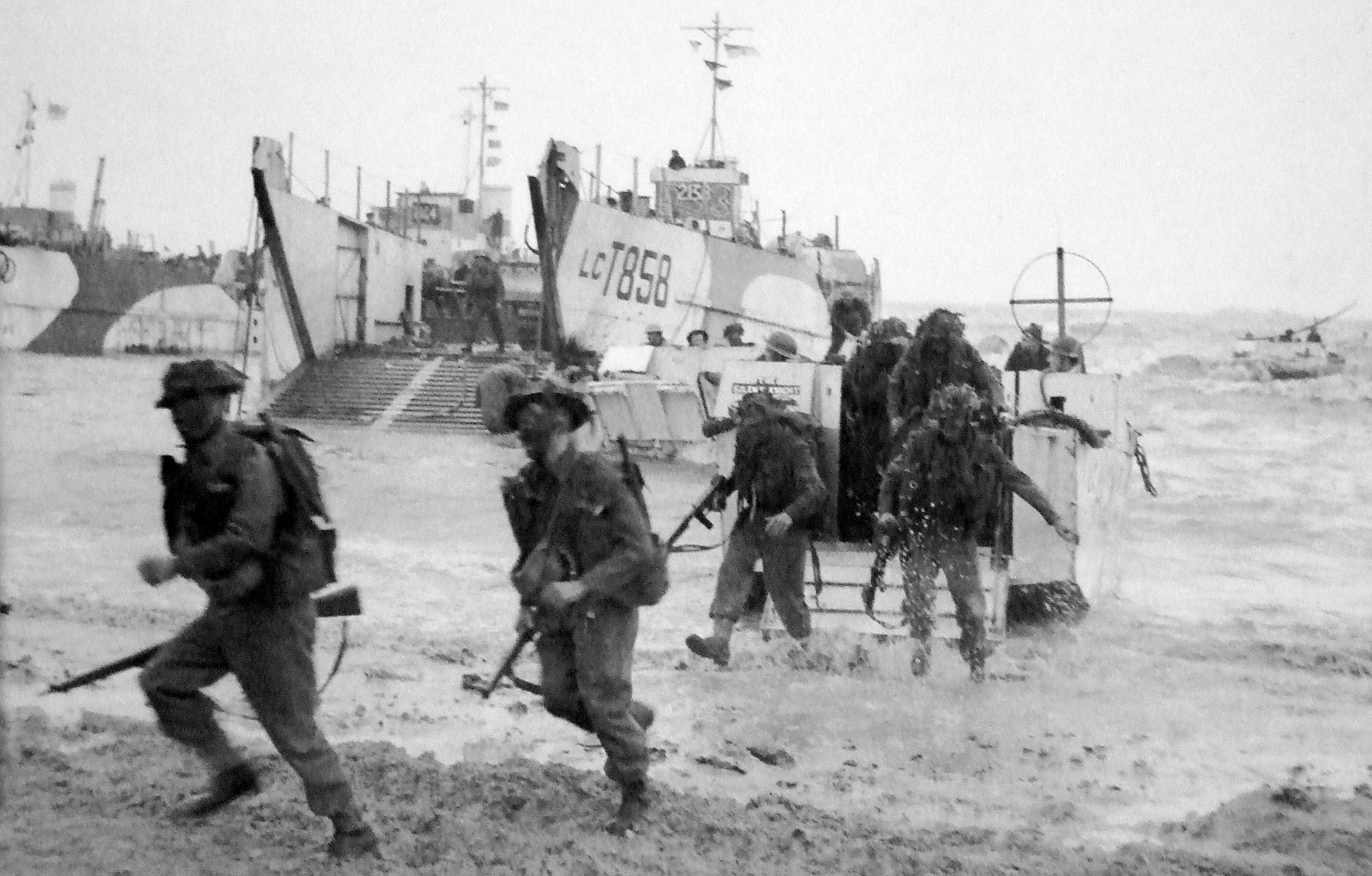
The fighting that opened the beach belongs in the account too, because it is what the harbour was built to exploit. The British 50th (Northumbrian) Infantry Division landed in the Jig and King sectors on the morning of 6 June 1944. The strongpoint at Le Hamel, on the western edge, held a 75-millimetre gun sited to fire in enfilade straight down the beach from behind a thick seaward wall, and it held out for most of the morning, doing real damage before it was finally taken from the landward side. It is on this beach that the only Victoria Cross awarded for actions on D-Day was earned, by Company Sergeant Major Stanley Hollis of the 6th Battalion, Green Howards, who cleared a German pillbox at the Mont Fleury battery and later, at Crépon inland, went back under fire to rescue men he had left pinned in a field. By nightfall 24,970 men had been landed at Gold, and the division was pushing toward Bayeux, which fell the next day, the first French town liberated. British casualties at Gold on the day are usually put at roughly 1,000 to 1,100, about 350 of them killed, a far lighter toll than Omaha's, though every figure from that morning is an estimate.

Two monuments anchor the memory. To the west at Longues-sur-Mer stands the only German coastal battery in Normandy that still has its guns in place: four 150-millimetre naval guns in their concrete casemates, which fired on the invasion fleet on D-Day morning and were silenced by Allied warships, including the French cruisers Georges Leygues and Montcalm. Above Ver-sur-Mer, about 700 meters inland from the beach, the British Normandy Memorial opened on the 77th anniversary, 6 June 2021, recording the names of the 22,442 service personnel under British command killed in the Normandy campaign, with the 1,746 who died on D-Day itself set on a separate wall.

That is the spike. Other beaches were bloodier. None is so completely defined by what was built rather than what was fought, and on no other beach is the machinery of the invasion still physically present in the water, in front of the deckchairs, at low tide. Gold is the supply beach, the engineering beach, the place where the liberation of Europe was kept fed, and the proof of it is still standing in the bay off Arromanches.

Aerial Gold Beach.jpg
Culture

Where it shows up

History
  • Mulberry "B" / Port Winston artificial harbour · 1944
    Allied military engineers

    The prefabricated harbour towed across the Channel and assembled off Arromanches to supply the British and Canadian beaches without a captured port. It survived the storm that destroyed its American twin and ran for about ten months as Port Winston; its caissons remain visible in the bay.

  • Victoria Cross of CSM Stanley Hollis · 1944

    The only Victoria Cross awarded for actions on D-Day was won by Company Sergeant Major Stanley Hollis of the Green Howards in the King sector of Gold Beach, for clearing a pillbox at the Mont Fleury battery and rescuing pinned comrades at Crépon. His medal is held by the Green Howards Museum.

Film
  • The Longest Day · 1962
    Darryl F. Zanuck (producer)

    The large-scale ensemble film of the D-Day landings, based on Cornelius Ryan's book, dramatizes the British and Commonwealth beaches among its multiple sequences. For decades it was the standard cinematic account of 6 June 1944.

Literature
  • D-Day: The Battle for Normandy · 2009
    Antony Beevor

    A widely cited narrative history of the Normandy campaign, including the British landings at Gold and the building of the Mulberry harbours, used as a general reference for the events of June 1944.

50th division.jpg
History

What happened here

  1. 1944battle

    The Gold Beach landing

    On 6 June 1944 the British 50th (Northumbrian) Infantry Division lands in the Jig and King sectors of Gold Beach, between Le Hamel and La Rivière, as part of Operation Overlord. The 231st Brigade lands at Le Hamel and Asnelles, the 69th at La Rivière and Ver-sur-Mer. The Le Hamel strongpoint holds out much of the morning. By nightfall 24,970 men are ashore; British casualties for the day are about 1,000–1,100, roughly 350 killed.

    Wikipedia →
  2. 1944military

    CSM Stanley Hollis earns the only D-Day Victoria Cross

    Company Sergeant Major Stanley Hollis of the 6th Battalion, Green Howards, landing in King sector, clears a German pillbox at the Mont Fleury battery and later, at Crépon inland, returns under fire to rescue men pinned in a field. His is the only Victoria Cross awarded for actions on D-Day, 6 June 1944.

    Wikipedia →
  3. 1944military

    Mulberry "B" assembled off Arromanches

    In the days after the landing, the Allies tow and assemble Mulberry "B," a prefabricated artificial harbour, off Arromanches to land supplies without a captured deep-water port. Sunken concrete Phoenix caissons form its breakwater, with floating Whale roadways carrying traffic to shore.

    Wikipedia →
  4. 1944disaster

    Storm wrecks Mulberry "A"; Mulberry "B" survives

    A severe Channel storm on 19 June 1944, the worst in decades, destroys the American Mulberry "A" off Omaha beyond repair; 21 of its 28 caissons are wrecked and it is abandoned. The British harbour off Arromanches survives, is reinforced with salvaged parts, and is renamed Port Winston after Churchill.

    Wikipedia →
  5. 1944military

    Port Winston runs for about ten months

    Designed to last three months, the Arromanches harbour operates for roughly ten, until the captured port of Antwerp takes over the supply burden late in 1944. Over its life it handles on the order of 2.5 million men, 4 million tons of supplies, and 500,000 vehicles. Its caissons remain in the bay.

    Wikipedia →
  6. 1954memorial

    Musée du Débarquement opens at Arromanches

    The Landing Museum (Musée du Débarquement) opens on the seafront at Arromanches on the 10th anniversary of D-Day, directly in front of the Mulberry harbour remains, telling the story of the artificial port. It was among the first D-Day museums in Normandy.

    Wikipedia →
  7. 2021memorial

    British Normandy Memorial unveiled at Ver-sur-Mer

    On 6 June 2021, the 77th anniversary, the British Normandy Memorial opens on high ground about 700 m inland from Gold Beach above Ver-sur-Mer. Designed by Liam O'Connor with sculptor David Williams-Ellis, it records the names of 22,442 killed under British command in Normandy, with 1,746 D-Day dead on a separate wall.

    Wikipedia →
  8. 2024commemoration

    80th-anniversary commemorations

    The 80th anniversary of the landings is marked along the Gold sector and at the British Normandy Memorial, among the last major commemorations expected to include living veterans of the invasion.

    Wikipedia →
The honest part
Out in the bay, in plain view of the ice-cream queues and the souvenir helmets, sit the concrete caissons of the harbour that landed two and a half million men.

Gold Beach holds a discomfort that is quieter than Omaha's but just as real: this is a battlefield that has become a tourist seafront, and the gear-change between the two registers happens on the same few hundred meters of Arromanches front. In summer the town is a busy resort, with car parks full, ice-cream queues, gift shops selling souvenir D-Day helmets and ration tins, and a beach used for ordinary swimming and sand-yachting; out in the bay, in plain view of all of it, sit the concrete caissons of the harbour that landed two and a half million men, and the war cemeteries and the memorial above Ver-sur-Mer hold the names of the men who did not go home. The commercialization is real and recurring, and so is the fact that Arromanches is a living town entitled to make a living. Both are true at once, and pretending the place is a pure shrine would be its own kind of dishonesty.

The numbers ask for the same restraint. The roughly 1,000 to 1,100 British casualties at Gold on 6 June, of whom about 350 were killed, is an estimate that varies by source, and Gold's lighter toll relative to Omaha can flatten in the retelling into a sense that it was easy. It was not easy for the men who took the Le Hamel strongpoint, or for the 50th Division as it ground inland and went on to take the heaviest divisional losses in Normandy in the weeks that followed. The harbour that makes this beach singular was an engineering triumph, but it was built to sustain a campaign that killed more than 22,000 men under British command alone before the end of August.

Allied Invasion Force.jpg
Anatomy

The shape of the place

Arromanches-les-Bains (Mulberry harbour)

20%

The western anchor and the busiest point: a small seaside resort whose seafront looks straight out at the sunken Phoenix caissons of Port Winston. The Musée du Débarquement sits on the front. Tour coaches turn over here through the day in summer.

Best for the Mulberry harbour ruins, the Landing Museum, low-tide walks out toward the nearer caissons

Off Arromanches the harbour breakwater is the main sight; at low tide some caissons are walkable-to. The beach is small and shelves gently.

Asnelles / Le Hamel (Jig sector)

45%

The Jig sector of 1944, where the 231st Brigade landed and the Le Hamel strongpoint, with its enfilading 75 mm gun, held out much of the morning. Today a flat, broad family beach used for swimming and sand-yachting, with the remains of the strongpoint nearby.

Best for flat-sand swimming, sand-yachting, the Le Hamel bunker remains

Open Channel beach with a large tidal range; the sea retreats a long way and returns quickly. No year-round lifeguard coverage.

Ver-sur-Mer / La Rivière (King sector)

75%

The King sector at the eastern end, where the 69th Brigade landed and CSM Stanley Hollis earned his Victoria Cross near the Mont Fleury battery. The British Normandy Memorial stands on high ground about 700 m inland above Ver-sur-Mer. A quiet, flat family beach.

Best for the British Normandy Memorial, the Mont Fleury battery site, broad flat-sand walks

The memorial is reached by road on the rise above the beach, not from the sand; it is a place of mourning, with names of 22,442 dead.

Landmarks

Mulberry "B" / Port Winston artificial harbour · 1944

fortification · Allied military engineers (caissons; Whale roadways by Allan Beckett)

The prefabricated artificial harbour assembled off Arromanches after D-Day, using sunken concrete Phoenix caissons as a breakwater, floating Spud pierheads, and Whale roadways. After the storm of 19 June 1944 wrecked its American twin off Omaha, it survived and was renamed Port Winston; it ran for about ten months, landing on the order of 2.5 million men. Its caissons still stand in the bay.

Wikipedia →

Longues-sur-Mer battery · 1944

fortification · Organisation Todt

A German Atlantic Wall coastal battery on the cliff between Gold and Omaha, built 1943–44, with four 150 mm naval guns of about 20 km range in concrete casemates. It shelled the invasion fleet on D-Day morning and was silenced by Allied warships, including the French cruisers Georges Leygues and Montcalm. It is the only battery in Normandy that still has its original guns in place.

Wikipedia →

British Normandy Memorial · 2021

memorial · Liam O'Connor (architect); David Williams-Ellis (sculptor)

On high ground about 700 m inland above Ver-sur-Mer, unveiled 6 June 2021. It records the names of 22,442 service personnel under British command killed in Normandy between 6 June and 31 August 1944, with the 1,746 D-Day dead on a separate wall; a bronze group of three soldiers coming ashore stands at its center.

Wikipedia →
A day here

From first light to dark

Dawn

At low water the tide is far out across the flat Norman sand, and the Mulberry caissons stand clear and grey out of the shallows off Arromanches under a low Channel light. The seafront is near-empty; a few early walkers and dog-owners have the beach before the town wakes and the first coaches arrive.

Midday

In summer Arromanches fills: the front is busy, the small beach is used by families, and the car parks turn over with D-Day coach tours bound for the museum, the cinema, and the Longues battery up the coast. At Asnelles and Ver-sur-Mer the broad flat sand is given over to swimmers and sand-yachts.

Golden hour

Late light rakes along the low coast and catches the wet ridges of sand as the tide pushes back in over the caissons off Arromanches. Day-trippers thin out; the harbour ruins, half-submerged again, sit dark against the brightening water.

Night

After dark the beaches empty and the small towns close early. There is no resort strip or boardwalk nightlife here of any scale; Arromanches goes quiet, and the bay with its sunken harbour is just a dark line of shapes offshore.

Compare

How it ranks

Peak warmth
Cooler than 75% of beaches in its country
Peak-month high ≈ 22°C

Ranked against every beach in our database — 228,000+ worldwide.

Batterie-longues-sur-mer.jpg
Sea & surf

What the water does

JFMAMJJASONDmetres (significant wave height)

Solid = typical monthly wave height; pale = the bigger days (90th pct). Offshore/regional swell from Open-Meteo Marine (ERA5 Ocean reanalysis, 2023–2024); a sheltered cove may sit calmer than this.

Mixed — usually swimmable, with a livelier season
Typical wave height
0.74 m
Biggest swell
Dec · 1.04 m
Calmest
Jul · 0.57 m
Typical period
4.1 s (wind chop)
Before you go

Things to know

The Mulberry ruins are the sight, and the tide rules them

The grey caissons off Arromanches are best seen at low water, when some are nearly walkable-to; at high tide they sit half-submerged. The spring tidal range is about 6.5 m, so the sea retreats a long way and returns quickly. Check the tide table.

Three beaches, three characters

Arromanches is the busy resort with the harbour and museum; Asnelles/Le Hamel and Ver-sur-Mer/La Rivière are quieter flat-sand family beaches used for swimming and sand-yachting. Seeing the harbour, the Longues battery, and the British Normandy Memorial is a half-day at least.

The memorial is a place of mourning

The British Normandy Memorial above Ver-sur-Mer names 22,442 dead. It is reached by road on the rise inland, not from the sand; quiet and appropriate dress are expected. The Longues-sur-Mer battery just west still holds live-looking guns in its casemates and is an open historic site.

Open Channel water, no year-round lifeguards

These are cool English Channel beaches with a large tidal range and no year-round lifeguard cover; supervision, where it exists, is summer-only. The water and weather are Norman, not Mediterranean.

Sharks

No incidents on record in the global shark-attack file.

Plan

If you go

Getting there
Nearest airport
Caen Carpiquet airport (CFR) · 18 km
Nearest town
Ver-sur-Mer · 0 km

Gold Beach is on the Calvados coast of Normandy, reached most easily by car. From Caen (Caen–Carpiquet airport, CFR, is about 18 km from Ver-sur-Mer) it is roughly a 30–40-minute drive; Arromanches, Asnelles, and Ver-sur-Mer are all common stops on D-Day coach tours from Caen and Bayeux. Bayeux, about 10 km south, is the practical base, with its own mainline rail station (Paris–Saint-Lazare to Bayeux is roughly 2.5 hours) and the closest large town; from Bayeux it is a short drive to Arromanches and the Mulberry harbour, the Longues-sur-Mer battery, and the British Normandy Memorial at Ver-sur-Mer.

When to go
  • D-Day anniversary commemorations · Every 6 June, with major ceremonies on round anniversaries

    Ceremonies along the Gold sector and at the British Normandy Memorial above Ver-sur-Mer mark the anniversary of the landing each 6 June; the 77th (2021, the memorial's unveiling) and 80th (2024) were notable, with ever fewer living veterans.

  • Summer season at Arromanches · July and August

    In peak summer Arromanches functions as a working seaside resort, its seafront and small beach busy with visitors who come for both the Mulberry harbour and an ordinary day at the coast.

What to eat & drink
Coquilles Saint-Jacques

Scallops from the Bay of the Seine, landed at the nearby fishing port of Port-en-Bessin a few kilometers west, one of Normandy's main scallop ports. In season (autumn to spring) they are a regional specialty, pan-seared or gratinéed with cream. There is no food on the sand itself; you eat in the towns behind it.

Restaurants in Arromanches-les-Bains and Port-en-Bessin-Huppain

Moules-frites

Mussels steamed in cider or white wine with shallots and served with fries, the standard plate along this coast. The seafront restaurants at Arromanches serve it looking out at the bay.

Seafront cafés and restaurants in Arromanches-les-Bains and Asnelles

Camembert, cider, and Calvados

This is Calvados, the département named for the apple brandy. The Norman trio is the local raw-milk cheese (Camembert, Pont-l'Évêque, Livarot are all regional), dry cider, and Calvados as a digestif; the pays d'Auge to the east is the cider and brandy heartland.

Village shops, farms, and restaurants across the Calvados coast

Teurgoule

A traditional lower-Normandy baked rice pudding, slow-cooked for hours with cinnamon until a dark skin forms. A regional dessert specific to the Bessin and surrounding country, not a tourist invention.

Bakeries and traditional restaurants in the Bessin behind the beach

Sources & references
  1. Wikipedia (Mulberry harbour); Institution of Civil Engineers · cited 3×
  2. Imperial War Museums; ForcesNews · cited 2×
  3. Wikipedia (Gold Beach); Britannica
  4. Naval History and Heritage Command; Wikipedia (Mulberry harbour)
  5. Musée du Débarquement Arromanches; Wikipedia
  6. Wikipedia (British Normandy Memorial); britishnormandymemorial.org
  7. Wikipedia (Normandy landings)
  8. Wikipedia (Gold Beach), citing official histories
  9. Wikipedia (Gold Beach); Britannica; figures are estimates, never a precise count
  10. Wikipedia (Mulberry harbour); Naval History and Heritage Command
  11. Wikipedia (Longues-sur-Mer battery); History Hit
  12. Wikipedia (British Normandy Memorial); some sources cite 22,540
  13. World Beach Tour beach data (EOT20 tidal model)
Colophon · Provenance

Where this page comes from

Geography, facilities
OpenStreetMap (ODbL) for geometry and facility tags within 500 m of the beach centroid. GeoNames for city/airport distances.
Climate & ocean
worldclim_v2.1_2.5m
Tides
eot20
Photography
Archival, original tone (Tier B — Wikimedia Commons). Each image licensed per its own terms; attribution visible inline.
History & culture
Every factual claim is linked to its source in the prose above. Wikipedia citations inline. Non-wiki sources named where relevant.
Editorial voice
Register: reverent. Written to pass a local's nod test; corrections welcome.
Written by Erin Rose
Last reviewed 2026-04-19
v0.9in editorial development toward v1.0