Limassol, CY

Governor's Beach

Small wooden pier in one of the Governor's Beach bays, Limassol, Cyprus (PPL1-Corrected) julesvernex2.jpg

Limassol, CY

Governor's Beach

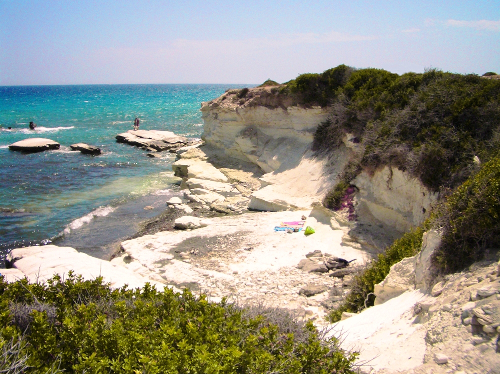
Hidden coves under brilliant white 'White Rocks' chalk cliffs above dark, scorching sand — a Cyprus beach named for a British governor, near Britain's last island base.

Small wooden pier in one of the Governor's Beach bays, Limassol, Cyprus (PPL1-Corrected) julesvernex2.jpg · <a href="//commons.wikimedia.org/wiki/User:Julesvernex2" title="User:Julesvernex2">Jules Verne Times Two</a> · CC BY-SA 4.0
Substrate
gravel
Nearest airport
AKT · 29 km
Tier
Featured
I’m here for
Story

Governor's Beach is a two-kilometer run of coast on the south side of Cyprus, roughly midway between Limassol and Larnaca, well off the main highway and mostly unknown to the crowds that fill the island's resort strips. It is Blue Flag rated, with deep, crystal-clear water, and it is defined by a single dramatic contrast that you see the moment you reach the top of the steps down to it: brilliant white cliffs above dark, near-black sand.

Those cliffs are the beach's signature. Known as the White Rocks, they are made of striking white chalk and limestone, and they stand in sharp visual opposition to the dark volcanic-grey sand at their feet, which soaks up the Cypriot sun and gets genuinely scorching in high summer. The effect, white stone over black sand over turquoise water, is unusual and photogenic, and it is the reason to come. Because of the structure of the shoreline, the beach is not one long strand but a series of well-hidden small coves, and that privacy has made it one of the few semi-official nudist spots on the island.

The experience is low-key and Cypriot rather than packaged. You reach the coves down steps from the highway; there is a daily bus but most people drive. The draw beyond the swimming is the food: Governor's Beach is known for its fish tavernas, serving fresh seafood and traditional Cypriot dishes on the shore, the kind of long, slow, grilled-fish lunch that is the real point of a Cypriot beach day. It is a place locals rate and tourists mostly miss.

The most interesting thing about it, though, is hidden in the name. Governor's Beach is named for the British colonial governors of Cyprus, who frequented this coast; the governor's actual summer residence was in the neighboring village of Maroni rather than on the beach itself, but the name stuck. That colonial imprint is not just historical. The nearest airfield to the beach is not a commercial airport but RAF Akrotiri, part of the Sovereign Base Areas of Akrotiri and Dhekelia, two pieces of Cyprus that Britain kept as its own sovereign territory when the island became independent in 1960, and which remain a British Overseas Territory to this day.

So Governor's Beach is a small, striking, off-the-strip Cypriot cove system with a genuinely unusual look, white cliffs, black sand, clear water, and it is quietly steeped in the island's British past, from the governor in its name to the RAF base next door. It is beautiful in a stark, high-contrast way, delicious if you like grilled fish, and, for anyone paying attention, a reminder that the map of this island still carries the fingerprints of empire.

The spike

Hidden coves under brilliant white 'White Rocks' chalk cliffs above dark, scorching sand — a Cyprus beach named for a British governor, near Britain's last island base.

Governor's Beach is a small beach that carries two outsized stories, one you can see from the top of the steps and one you have to know the island to read. The first is a striking piece of geology. The second is a living piece of the British Empire. Together they make a quiet Cypriot cove far more interesting than its size suggests.

The White Rocks and the black sand. The thing you notice immediately is the contrast. Governor's Beach runs for about two kilometers on the south coast of Cyprus, midway between Limassol and Larnaca, well off the resort strips, and it sits at the foot of brilliant white cliffs, the White Rocks, made of striking chalk and limestone. Below them is dark, near-black sand. The pairing, white stone over black sand over deep turquoise water, is genuinely unusual and is the whole visual identity of the place. The dark sand has a practical consequence that the postcards skip: it absorbs the fierce Cypriot sun and becomes painfully hot underfoot in high summer, which is why sandals and a non-midday visit are the local wisdom. The beauty here is stark and high-contrast, not soft and golden, and it is better for it.

A beach of hidden coves. Because of the way the shoreline is cut, Governor's Beach is not a single strand but a series of small, well-hidden coves, reached by steps down from the highway. That structure gives it a privacy the big resort beaches lack, and it has made Governor's Beach one of the few semi-official nudist spots on the island. It is a quiet, local, unpackaged place; the daily bus notwithstanding, most people drive, and the real ritual is not so much the swim as the long, slow lunch at one of the fish tavernas the beach is known for, fresh grilled fish and Cypriot meze on the shore.

The governor in the name. The second story is hidden in plain sight, in the name. Governor's Beach is named for the British colonial governors of Cyprus, who frequented this coast during the decades of British rule. The governor's summer residence was not actually on the beach but in the neighboring village of Maroni; still, the name that stuck was Governor's Beach, and it has quietly preserved a fragment of colonial history in an everyday place name ever since. Britain administered Cyprus from 1878 and made it a Crown Colony in 1925, and this beach's name is a small, casual souvenir of that era.

The base next door. And the colonial imprint is not confined to the name; it is still operational. The nearest airfield to Governor's Beach is not a commercial airport but RAF Akrotiri, part of the Sovereign Base Areas of Akrotiri and Dhekelia. When Cyprus became independent in 1960, the United Kingdom retained these two areas of the island as its own sovereign territory, and they remain a British Overseas Territory today, an active, unusual remnant of empire embedded in an EU member state. To sit on Governor's Beach is to sit on a beach named for an imperial governor, a short distance from a piece of Britain that never left. The Sovereign Base Areas cover a meaningful stretch of the island's south and remain among the very few inhabited pieces of formal British sovereignty left anywhere; RAF Akrotiri is a working forward air base, not a relic. That the closest runway to a quiet Cypriot swimming cove belongs to a foreign air force is the kind of detail only this island's particular history could produce.

Why it matters. Governor's Beach earns its place not as a famous beach, it is deliberately not one, but as a beach that rewards a second look. Its surface is a rare and beautiful geological contrast, white cliffs, black sand, clear water, best enjoyed with sandals and a plate of grilled fish. Its depth is the quiet, unresolved history of a much-fought-over island: named for the governors of an empire, sitting beside that empire's last local outpost, on a coast that Cypriots love and most tourists never find. It is the kind of place that looks, at first, like a simple pretty cove, and turns out, if you read it, to hold both the geology of the island and its politics in one small, hot, high-contrast bay.

Sunset at Governor's Beach, Cyprus - panoramio.jpg
Culture

Where it shows up

History
  • The name of a governor

    Governor's Beach takes its name from the British colonial governors of Cyprus who frequented this coast, an everyday trace of the island's British administration written into a beach name.

  • The Sovereign Base Areas · 1960

    Akrotiri and Dhekelia, the two pieces of Cyprus Britain kept as sovereign territory at independence, an active British Overseas Territory whose airfield is the nearest to the beach, a live remnant of empire on the island.

Other
  • The fish-taverna day

    The Cypriot ritual of the long, slow grilled-fish lunch by the sea, for which Governor's Beach and its tavernas are locally beloved, the social heart of a day here.

Governor's Beach.JPG
History

What happened here

  1. 1878historic

    British administration begins

    Britain takes over the administration of Cyprus from the Ottoman Empire in 1878. The era of British colonial governors that follows is what eventually gives Governor's Beach its name.

    Wikipedia →
  2. 1925historic

    Cyprus becomes a Crown Colony

    Cyprus is formally made a British Crown Colony in 1925, deepening the colonial administration whose governors frequented this stretch of the south coast, with a summer residence in nearby Maroni.

    Wikipedia →
  3. 1960policy

    Independence and the Sovereign Base Areas

    Cyprus becomes independent in 1960, but under the independence treaty Britain retains two pieces of the island, Akrotiri and Dhekelia, as Sovereign Base Areas. RAF Akrotiri, the nearest airfield to Governor's Beach, is part of this British Overseas Territory to this day.

    Wikipedia →
  4. 2005policy

    A quiet Blue Flag holiday coast

    In the modern era Governor's Beach settles into its role as a Blue Flag holiday spot known for its coves and fish tavernas, popular with Cypriots and largely off the main international tourist trail.

    Wikipedia →
The honest part
The white cliffs are the postcard; the name is the history lesson.

The honest layers of Governor's Beach are two, one geological and one geopolitical, and both are more interesting than the usual beach copy. The geological one is simple: the beauty here is a contrast, white chalk cliffs over dark, heat-trapping sand, and the same dark sand that makes the look so striking also becomes genuinely painful underfoot in the height of summer. It is a beach that rewards sandals and an early or late visit, and pretending the black sand is a soft golden strand would be a lie. The beauty is real and it is austere.

The geopolitical layer is the one worth sitting with. Governor's Beach wears Cyprus's colonial history openly: it is named for the British governors who once ran the island, and its nearest airfield, RAF Akrotiri, is not Cypriot territory at all but part of the Sovereign Base Areas that the United Kingdom retained as its own when Cyprus became independent in 1960. Those bases are still a British Overseas Territory, an active, unusual remnant of empire on an EU member's island. None of this darkens a swim, but it is the honest context: a lovely, quiet Cypriot beach whose very name and whose nearest runway are inheritances of the imperial past, on an island that has spent the decades since independence dealing with the complicated legacies of others' power. The white cliffs are the postcard. The name is the history lesson.

Governor's Beach, Cyprus - panoramio (58).jpg
Anatomy

The shape of the place

The fish tavernas

30%

The shoreside tavernas the beach is famous for, serving fresh grilled fish and Cypriot meze, the social heart of a Governor's Beach day and the reason many Cypriots make the trip.

Best for A long grilled-fish lunch; Cypriot meze by the sea

The food is a bigger draw here than any resort infrastructure.

The hidden coves

40%

The series of small, well-hidden coves along the 2 km shore, reached by steps from the highway. The privacy of the coves has made this one of the few semi-official nudist spots on Cyprus.

Best for Quiet swimming, secluded coves, a private beach day

Some coves are informally clothing-optional; the shoreline is broken into separate pockets.

The White Rocks and dark sand

50%

The signature stretch, where the brilliant white chalk-and-limestone cliffs stand directly above the dark, sun-scorched sand and clear deep water. The high-contrast landscape that defines Governor's Beach.

Best for The white-cliffs-over-black-sand view; swimming in the deep clear water

The dark sand gets very hot in high summer; the water is deep and crystalline.

Landmarks

The White Rocks

cliffs

The striking white chalk-and-limestone cliffs above Governor's Beach, in sharp contrast to the dark sand below, the natural feature that gives the beach its distinctive look.

Wikipedia →

RAF Akrotiri / the Sovereign Base Areas · 1960

military base

The nearest airfield to the beach, part of the Akrotiri and Dhekelia Sovereign Base Areas, British Overseas Territory retained by the UK when Cyprus became independent in 1960, a living remnant of the island's colonial history.

Wikipedia →

Maroni

village

The nearby village that held the British governor's summer residence, the source, at one remove, of the beach's name.

Wikipedia →
A day here

From first light to dark

Dawn

Early, the coves are empty and the dark sand is still cool, the white cliffs catching the first light above the flat, clear water. Before the heat, before the crowds and the tavernas open, Governor's Beach is at its most private and its most striking, the white-over-black contrast sharpest in the low sun.

Midday

By midday in summer the contrast is at full blast: the White Rocks glare, the dark sand is scorching underfoot, and swimmers take the deep, clear, cool water off the coves. This is when the beach earns its sandals-required reputation, and when the shaded taverna terraces fill.

Golden hour

Late afternoon warms the white cliffs to cream and gold and softens the harsh midday glare. The dark sand cools enough to walk, the light on the water is at its best, and the beach shifts toward its evening rhythm of long taverna dinners on the shore.

Night

After dark Governor's Beach is quiet, a string of dark coves under pale cliffs, the fish tavernas lit and busy with slow dinners, the island's south coast stretching away. Far from the resort strips, it keeps the low, local, unhurried feel that is its whole character.

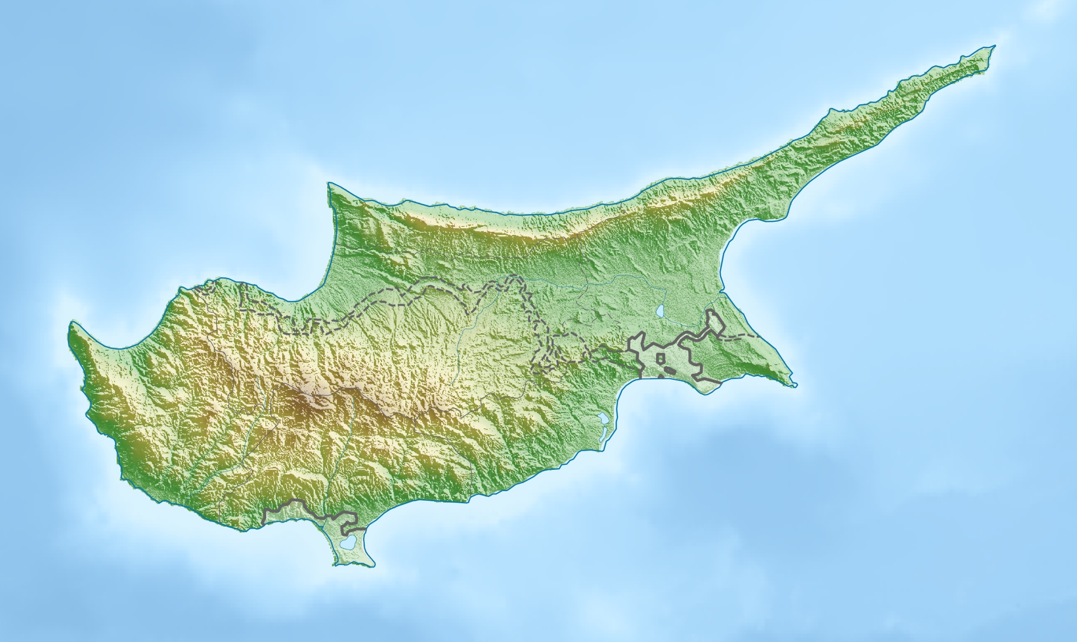
Cyprus relief location map.jpg
Sea & surf

What the water does

JFMAMJJASONDmetres (significant wave height)

Solid = typical monthly wave height; pale = the bigger days (90th pct). Offshore/regional swell from Open-Meteo Marine (ERA5 Ocean reanalysis, 2023–2024); a sheltered cove may sit calmer than this.

Mixed — usually swimmable, with a livelier season
Typical wave height
0.65 m
Biggest swell
Jan · 0.86 m
Calmest
Oct · 0.44 m
Typical period
5.4 s (wind chop)
Before you go

Things to know

Bring sandals for the black sand

The dark sand at Governor's Beach absorbs the sun and gets genuinely scorching in high summer, painful to cross barefoot at midday. Wear sandals or water shoes, and consider an early-morning or late-afternoon visit.

It's coves, not one big beach

The shoreline is a series of small, hidden coves reached by steps from the highway, not a single strand. That structure gives it privacy, and some of the coves are informally clothing-optional; it's one of Cyprus's few semi-official nudist spots.

Come for the fish tavernas

Beyond the swimming, the fish tavernas are the point. A long grilled-fish and meze lunch by the sea is the classic Governor's Beach experience and the reason locals make the trip.

Getting there

Governor's Beach is off the highway between Limassol (~30 km) and Larnaca (~40 km); a car is easiest, though a daily bus runs. Note the nearest airfield, RAF Akrotiri, is a British military base, not for civilian flights, so fly into Larnaca (LCA) or Paphos (PFO).

Sharks

No incidents on record in the global shark-attack file.

Plan

If you go

Getting there
Nearest airport
RAF Akrotiri (AKT) · 29 km
Nearest town
Pyrgos · 9 km

Governor's Beach is on Cyprus's south coast, off the main highway roughly midway between Limassol (about 30 km west) and Larnaca (about 40 km east). A car is the easiest way in, down steps from the road to the coves, though a daily bus runs. Civilian visitors fly into Larnaca International (LCA) or Paphos (PFO); the nearer RAF Akrotiri is a British military airfield, not a commercial airport.

When to go
  • The summer beach and taverna season · Late spring to autumn

    The warm Cypriot season is when the coves fill with swimmers and the fish tavernas do their trade, the everyday rhythm of a beach that lives on locals and long lunches more than on events.

  • Sunday fish lunch · Weekends, year-round

    The weekend grilled-fish lunch at the shore tavernas is the reliable draw, a Cypriot family ritual that keeps Governor's Beach busy well beyond the swimming season.

What to eat & drink
The Governor's Beach fish tavernas

The beach is known above all for its fish tavernas, serving fresh seafood and traditional Cypriot dishes right on the shore. A long, slow lunch of grilled fish and meze here is, for many Cypriots, the real reason to come.

On and above Governor's Beach

Cypriot meze and the meat/fish spread

Cyprus's table runs to the full meze, halloumi, souvlaki, sheftalia, taramasalata, olives, and grilled fish or lamb, washed down with the local Keo or Zivania. The tavernas here lean to the fish end of that spread.

Governor's Beach and the surrounding villages

Limassol and Larnaca

The two cities the beach sits between, each about half an hour away, hold the wider dining, nightlife, and supplies of the south coast for anyone making a longer trip of it.

Limassol (~30 km) and Larnaca (~40 km)

Sources & references
  1. Wikipedia: Governor's Beach · cited 6×
  2. Wikipedia: Akrotiri and Dhekelia · cited 3×
  3. Wikipedia: Cyprus
  4. Wikipedia: British Cyprus
  5. Beach data
Colophon · Provenance

Where this page comes from

Geography, facilities
OpenStreetMap (ODbL) for geometry and facility tags within 500 m of the beach centroid. GeoNames for city/airport distances.
Climate & ocean
Open-Meteo ERA5 + Marine archive, 2014–2023 monthly normals.
Photography
Archival, original tone (Tier B — Wikimedia Commons). Each image licensed per its own terms; attribution visible inline.
History & culture
Every factual claim is linked to its source in the prose above. Wikipedia citations inline. Non-wiki sources named where relevant.
Editorial voice
Register: wry. Written to pass a local's nod test; corrections welcome.
Written by Erin Rose
Last reviewed 2026-04-19
v0.9in editorial development toward v1.0