Hawaii, US

Hanakapiʻai Beach

Hanakapiai Beach, Kalalau Trail, Napali Coast, Kapaa - panoramio.jpg

Hawaii, US

Hanakapiʻai Beach

A beach with a sign tallying its drowning victims, reached only on foot or by sea, where rip currents and a six-mile gap to safe shore make swimming lethal.

Hanakapiai Beach, Kalalau Trail, Napali Coast, Kapaa - panoramio.jpg · <a rel="nofollow" class="external text" href="https://web.archive.org/web/20161031221920/http://www.panoramio.com/user/7508506?with_photo_id=117742932">Bob Linsdell</a> · CC BY 3.0
Nearest airport
BKH · 28 km
Tier
Featured
I’m here for
Story

Hanakapiʻai Beach sits on the Nā Pali Coast of northwest Kauaʻi, at 22.209 N, 159.598 W, two miles along the Kalalau Trail from Keʻe Beach in Hāʻena State Park. No road reaches it. The only ways in are that two-mile trail, which climbs and falls roughly 1,200 feet along the cliff face, or a boat landing in calm summer water. There are no lifeguards, no facilities, no fresh water, and no reliable cell service.

The beach is seasonal. During the summer months the sand is exposed and the cove reads as a strand. In winter, powerful waves and high tides strip the sand away and scour the cove down to boulders and bare rock. The Open-Meteo Marine reanalysis records an annual mean wave height of about 2.05 meters here, rising to a January mean near 3.21 meters and a recorded big-day height of 4.68 meters. This is a heavy, surf-driven coast.

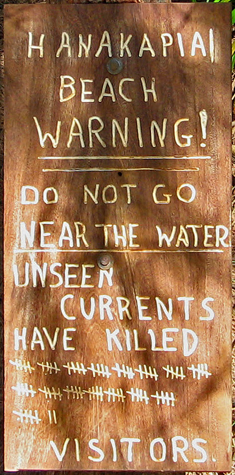
What the beach is known for is the dying. A wooden sign near the shore tallies drowning victims; tourists have counted 82 marks as of August 2014, a figure the beach's own documentation calls unofficial and speculative. A more conservative, sourced count holds that about 30 people are known to have drowned here between 1970 and 2010, and that at least 15 bodies have never been recovered. The Nā Pali Coast has no major reefs to break the swell, so currents run unhindered. Anyone swept off the beach faces a nearest safe shore roughly six miles away. There is no exit and no rescue in the minutes a drowning takes.

Hanakapiʻai Stream crosses the back of the beach and drains the valley behind it. Heavy rain inland, which a hiker on the beach cannot see, can send a flash flood down the stream within minutes, cutting off the crossing and trapping people on the far side. The same stream feeds Hanakapiʻai Falls, a roughly 300-foot waterfall two miles further inland up an unmaintained, repeatedly stream-crossing trail.

Since the 2018 north-shore floods washed out the road and damaged Hāʻena State Park, access has been rebuilt around a reservation system. After the park reopened in 2019, day hikers must reserve parking and entry in advance through the state's gohaena.com system; arriving without a reservation means being turned away at the gate. The reservation governs the only legal land approach to the trailhead.

This is a hazard page, not an invitation. The beach is the destination of one of Hawaiʻi's most dangerous day hikes, and its defining feature is a count of the people the water has taken.

The spike

A beach with a sign tallying its drowning victims, reached only on foot or by sea, where rip currents and a six-mile gap to safe shore make swimming lethal.

Most beaches are sold on what they show you. Hanakapiʻai is defined by what it counts. Near the shore stands a wooden sign with carved tally marks, one for each person the water is said to have taken, and that sign — not the sand, not the cliffs — is the thing the beach is known for. It is a hazard memorial standing on the destination itself.

The number is contested, and the contest is the point. Visitors have read 82 tally marks on the sign as of August 2014, and that figure travels widely. The beach's own documentation flags it as unofficial and speculative — marks can be added by anyone, and no agency maintains the sign as a record. The more defensible, sourced count is narrower and still grim: roughly 30 people known to have drowned here between 1970 and 2010, with at least 15 bodies never recovered. Whether the true toll is 30 or 82, both numbers describe the same fact. People come to this beach and do not leave it.

Why the water actually kills. The danger is structural, not incidental. The Nā Pali Coast has no major fringing reef to absorb the Pacific swell, so the surf and the currents arrive at the beach at full strength. The Open-Meteo Marine reanalysis puts the annual mean wave height near 2.05 meters, climbing to a January mean of about 3.21 meters and a recorded peak day of 4.68 meters. There are no lifeguards, because the beach is two miles from the nearest road and there is no way to staff it. And if a swimmer is pulled off the beach, the nearest safe shore is about six miles away along a cliff coast with no landing. A rip current here is not a scare; it is a one-way trip.

The seasonal trap. The beach changes with the season in a way that misleads people. In summer the sand is exposed, the surf eases, and the cove looks like a place you could swim. In winter, powerful waves and high tides strip the sand off entirely and scour the cove down to boulders and bare rock. The calm summer face is the dangerous one, because it is the one that invites entry. The water is never safe; it only sometimes looks safe.

The valley adds its own hazard. Hanakapiʻai Stream crosses the back of the beach and drains the valley that rises behind it toward Hanakapiʻai Falls, a roughly 300-foot waterfall two miles inland. That stream is the second killer. Rain falling in the high valley — rain a hiker standing on the beach cannot see — can send a flash flood down the channel within minutes, cutting off the crossing and stranding people on the wrong side. The same drainage that makes the falls hike possible makes the beach a place you can be trapped.

Access enforces the seriousness. You cannot stumble onto Hanakapiʻai. The only land route is the first two miles of the Kalalau Trail from Keʻe Beach, climbing and dropping about 1,200 feet along exposed cliff with long drops to the sea, open only between sunrise and sunset. Since the 2018 north-shore floods washed out the road and forced a 2019 reopening under a reservation system, even reaching the trailhead requires booking parking and entry in advance through the state's gohaena.com platform. Every layer of getting here — the reservation, the cliff hike, the daylight-only window — is a filter that the beach's own danger justifies. The sign at the end of the walk is the honest summary of everything the trail asked of you: this far, and no farther into the water.

Looking West on Hanakapi'ai Beach, Kauai - panoramio.jpg
Culture

Where it shows up

Other
  • The counted-dead warning sign · 2014

    The tally sign has become the symbol of the beach in travel media and photography, repeated as shorthand for the danger of the Nā Pali Coast. The 82-mark count circulated widely despite being unofficial.

  • Nā Pali Coast on film

    The Nā Pali cliffs and valleys, including the wilderness around Hanakapiʻai, have appeared as backdrop in feature films shot on Kauaʻi's north shore, contributing to the coast's image as untouched wilderness.

Hanakapiai Beach Warning Sign Only.jpg
History

What happened here

  1. 1970other

    Modern drowning record begins

    The sourced count of Hanakapiʻai drownings dates from about 1970; roughly 30 people are known to have drowned here between 1970 and 2010, with at least 15 bodies never recovered.

    Wikipedia →
  2. 2014cultural

    Warning sign counted at 82 marks

    As of August 2014, visitors counted 82 tally marks on the wooden warning sign near the beach, each representing a drowning victim. The figure is widely repeated but described as unofficial and speculative.

    Wikipedia →
  3. 2018natural

    North-shore floods wash out access

    Record April 2018 rainfall on Kauaʻi's north shore caused catastrophic flooding and landslides, washing out the road to Hāʻena and closing the state park and the Kalalau Trail trailhead.

  4. 2019policy

    Park reopens with reservation system

    Hāʻena State Park reopened in June 2019 after repairs, introducing a mandatory advance reservation and shuttle system for parking and entry, managed through the state's gohaena.com platform.

The honest part
Most beaches sell an image; Hanakapiʻai keeps a tally.

The sign is the honest part. Most beaches sell an image; Hanakapiʻai keeps a tally. The exact number on the wooden marker is disputed — visitors have read 82 tally marks, the beach's own documentation calls that figure unofficial, and the better-sourced count is about 30 known drownings from 1970 to 2010 with at least 15 bodies never recovered. The dispute over the number does not soften the fact it records: people die here, and they die because the conditions are built to kill. There is no reef to break the Nā Pali swell, the nearest safe shore is roughly six miles off, and there are no lifeguards on a beach two miles from the nearest road. The water looks survivable on a calm summer afternoon, which is exactly the trap. The same valley that draws hikers to Hanakapiʻai Falls also drains flash floods down the stream that crosses the beach, and people have been stranded and killed by water that arrived from rain they never saw. The sober reading is that the beach is worth reaching and not worth entering — that the correct relationship to this stretch of the Pacific is to stay out of it.

Cat Friends (209049579).jpeg
Anatomy

The shape of the place

Kalalau Trail, miles 0–2

0%

The two-mile cliff-edge approach from Keʻe Beach, climbing and dropping about 1,200 feet over roots, loose rock, and exposed switchbacks with long drops to the sea.

Best for The only land access to the beach

Open sunrise to sunset; night hiking prohibited. Requires advance Hāʻena State Park reservation via gohaena.com.

The warning sign

45%

A wooden marker near the shore tallying drowning victims, read by visitors at 82 marks as of August 2014. The defining object of the beach.

Best for Understanding the actual hazard before deciding anything

The tally is unofficial; the sourced count is about 30 known drownings 1970–2010, at least 15 unrecovered.

The seasonal cove

50%

A roughly one-mile crescent at the foot of the Nā Pali valley. Sand is exposed in summer and scoured to boulders and bare rock by winter surf and high tides. No reef offshore to break the swell.

Best for Reaching the Pacific on foot, photography, the turnaround point

No lifeguards, no facilities. Swimming is dangerous year-round; the nearest safe shore if swept out is about six miles away.

Hanakapiʻai Stream crossing

80%

The stream that drains the valley and crosses the back of the beach. Ankle-deep in dry conditions; it drives the falls-bound trail inland and can flash-flood within minutes after upstream rain.

Best for The route toward Hanakapiʻai Falls

Do not drink the water (leptospirosis risk). A rising stream can trap hikers on the far side; turn back if rain threatens.

Landmarks

Hanakapiʻai drowning warning sign

marker

A wooden sign near the beach tallying drowning deaths with carved marks, counted by visitors at 82 as of August 2014. It is the beach's most recognized feature and the subject of most of its photographs.

Wikipedia →

Hanakapiʻai Falls

natural

A waterfall of roughly 300 feet (visible drop) at the head of the valley, two miles inland from the beach up an unmaintained trail with repeated stream crossings. The full drop is reported higher, with about 300 feet visible from the valley floor.

Wikipedia →

Nā Pali Coast cliffs

natural

The fluted volcanic sea cliffs of Kauaʻi's northwest coast, rising thousands of feet, that enclose the Hanakapiʻai valley and make the beach reachable only on foot or by sea.

Wikipedia →
A day here

From first light to dark

Dawn

The first hikers leave Keʻe Beach at first light to make the two miles before the heat, while the cove is still in the shadow of the valley walls and the surf shows its overnight size. There are no lights on the trail; hiking before dawn is unsanctioned and the trail officially opens at sunrise.

Midday

By late morning the beach holds its day-trip crowd: people who hiked in, ate, photographed the cliffs and the warning sign, and most of whom do not enter the water. In summer the sand is exposed and the stream crossing is ankle-deep; the falls-bound continue two more miles inland.

Golden hour

Late afternoon light rakes the green valley walls and the boulders at the waterline while the lower beach falls into shade. This is the turnaround deadline: hikers must clear the two-mile trail before dark, when cliff exposure and loose footing become lethal.

Night

After sunset the beach is empty and unlit, with no facilities, no staff, and no one permitted to stay without an overnight Kalalau camping permit obtained separately. The trail is closed to night hiking; the only presence is the surf working the cove and, on clear nights, an unusually dark sky over the wilderness coast.

Hanakapiai Stream, Kalalau Trail, Napali Coast, Kapaa (502900) (16723036458).jpg
Sea & surf

What the water does

JFMAMJJASONDmetres (significant wave height)

Solid = typical monthly wave height; pale = the bigger days (90th pct). Offshore/regional swell from Open-Meteo Marine (ERA5 Ocean reanalysis, 2023–2024); a sheltered cove may sit calmer than this.

Heavy — a powerful, surf-driven coast
Typical wave height
2.05 m
Biggest swell
Jan · 3.21 m
Calmest
Jul · 1.36 m
Typical period
10 s (groundswell)
Before you go

Things to know

Reservation required

Hāʻena State Park parking and entry require an advance reservation via gohaena.com; without one you are turned away at the gate. Day hiking to Hanakapiʻai needs no separate permit, but overnight Kalalau camping does.

Do not swim

No reef breaks the swell, there are no lifeguards, and the nearest safe shore if swept out is about six miles away. A sign tallies the drownings; treat the water as off-limits.

Flash-flood risk

Hanakapiʻai Stream can rise within minutes after rain you cannot see upstream, cutting off the crossing. Turn back if rain threatens and do not drink the stream (leptospirosis).

The hike

Two miles each way from Keʻe Beach, about 1,200 feet of cumulative gain over exposed cliff trail. Open sunrise to sunset; carry at least three liters of water; the falls add four miles round trip on an unmaintained trail.

Surf & rip

Powerful water — strongest around Jan, gentlest in Jul. Mind rip currents; this isn't a wade-in-anywhere beach.

Sharks

No incidents on record in the global shark-attack file.

Plan

If you go

Getting there
Nearest airport
Barking Sands Airport (BKH) · 28 km
Nearest town
Princeville · 12 km

No road reaches the beach. Land access is the first two miles of the Kalalau Trail from Keʻe Beach in Hāʻena State Park, which requires an advance reservation via gohaena.com. Summer-only boat landings are possible in calm water. Nearest town for supplies is Hanalei; nearest commercial airport is Līhuʻe (LIH), about 40 miles south.

What to eat & drink
Nothing at the beach

Hanakapiʻai has no kiosk, taverna, shade structure, or potable water. Hikers must carry all food and at least three liters of water in and pack all trash out. The stream is not safe to drink and can carry leptospirosis.

Plan around the trail, not the beach

Provisioning in Hanalei

The last real town before the road ends, Hanalei has grocery stores and restaurants where hikers buy supplies for the trail. It is roughly 18 miles southeast of the Hāʻena trailhead on Kūhiō Highway.

Hanalei town, Kauaʻi north shore

Sources & references
  1. Wikipedia: Hanakāpīʻai Beach · cited 7×
  2. Hawaiʻi DLNR; Hāʻena State Park notices
  3. Hawaiʻi DLNR Division of State Parks; gohaena.com
  4. site/data/beaches/hanakapi-ai-beach.json
  5. Wikipedia: Hanakāpīʻai Beach; Hawaiʻi DLNR
  6. Hawaiʻi DLNR Division of State Parks
Colophon · Provenance

Where this page comes from

Geography, facilities
OpenStreetMap (ODbL) for geometry and facility tags within 500 m of the beach centroid. GeoNames for city/airport distances.
Climate & ocean
Open-Meteo ERA5 + Marine archive, 2014–2023 monthly normals.
Photography
Archival, original tone (Tier B — Wikimedia Commons). Each image licensed per its own terms; attribution visible inline.
History & culture
Every factual claim is linked to its source in the prose above. Wikipedia citations inline. Non-wiki sources named where relevant.
Editorial voice
Register: severe. Written to pass a local's nod test; corrections welcome.
Written by Erin Rose
Last reviewed 2026-04-19
v0.9in editorial development toward v1.0