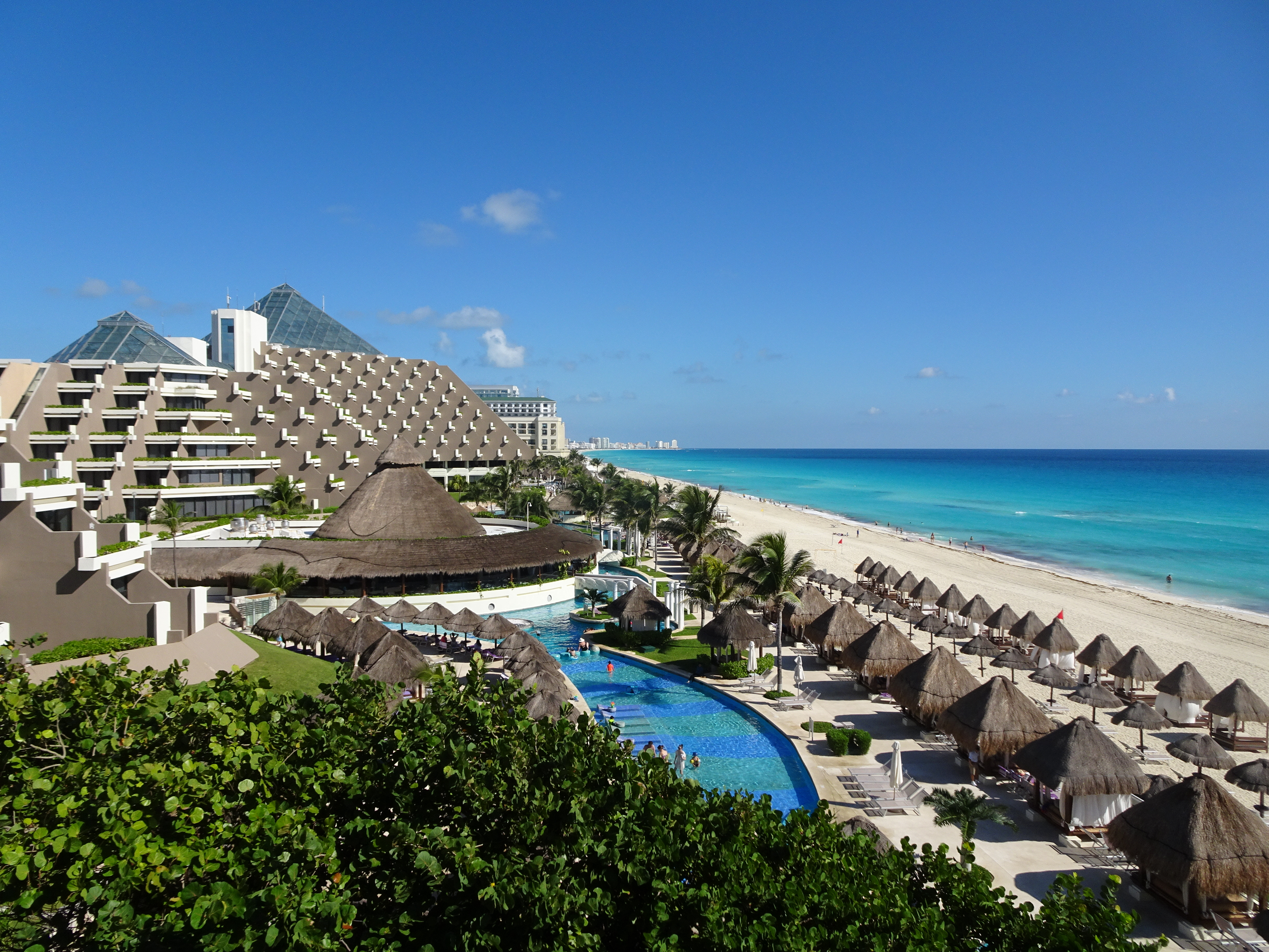
Quintana Roo, MX

Hotel Zone

Cancun (Mexico, November 2018) - 31 (50999277441).jpg

Quintana Roo, MX

Hotel Zone

In 1969 a Bank of Mexico trust scored coastlines by computer and picked this mangrove island, population three, to become Cancún.

Cancun (Mexico, November 2018) - 31 (50999277441).jpg · <a rel="nofollow" class="external text" href="https://www.flickr.com/people/37003135@N00">Bruno Rijsman</a> · CC BY-SA 2.0
Nearest airport
CUN · 17 km
I’m here for
Story

The Hotel Zone, Zona Hotelera, is a 22.5-kilometer barrier island shaped like the numeral 7, running along one road, Boulevard Kukulcán, between the Caribbean Sea and the Nichupté Lagoon. It is not a town that grew into a resort; it is a resort built where no town had been, on Mexico's Yucatán coast in Quintana Roo. Every hotel along the road faces either the sea or the lagoon, because the island is barely wide enough for both.

The island became a destination because a government trust ran the numbers and picked it. In 1967 Mexico gave the Bank of Mexico $2 million to find a resort site. INFRATUR, the bank's tourism unit, fed data from Miami Beach and Acapulco into a computer, visitor counts, hotel rooms, temperature, rainfall, hurricanes, and scored candidate coastline. Officials inspected the finalists in person and picked a mostly uninhabited mangrove island whose only year-round residents were three caretakers of a coconut plantation. Construction broke ground January 23, 1970; the first hotel opened September 1974.

The federal government financed the first nine hotels because private investors weren't yet convinced. By 1981, over $1.1 billion had built 48 hotels, a convention center, and a golf course; that October, the Cancún Sheraton Hotel hosted 22 national delegations, eight industrialized and fourteen developing, for the North-South Summit, while the new convention center served as the event's press headquarters. The zone now holds more than 190 hotels and 35,000 rooms; tourism accounts for about 87 percent of Quintana Roo's economic activity, per state tourism officials.

The engineering did not make the island stable. Hurricane Wilma came ashore just west of the zone in October 2005, destroying or damaging 110 hotels. Mexico's largest beach nourishment to that date, about $19 million of dredged sand, rebuilt the shoreline in 2006. The sand itself is not what this page's pipeline data predicts: a global model flags it quartz-dominant, but published research on Cancún describes aragonite, largely star-shaped foraminifera shells.

Since 2015, sargassum has washed onto these beaches most summers, and 2025 was the largest Navy-era collection year to that point, a mark 2026 has since surpassed: Quintana Roo had collected more than 76,800 tonnes by mid-September, more than 87,000 tonnes for the full season, more than double 2024's roughly 37,000-40,000 tonnes, per Mexico's Navy. The zone still earned 49 Blue Flag distinctions, 7 public beaches, 4 hotels, and 38 tour vessels, for 2025-2026, and the U.S. State Department held Quintana Roo at Level 2, "exercise increased caution," in its May 2026 update. The result: one of the Americas' most engineered tourist landscapes, still negotiating hurricanes, algae, and its own currents.

The spike

In 1969 a Bank of Mexico trust scored coastlines by computer and picked this mangrove island, population three, to become Cancún.

The Hotel Zone is the rare beach destination whose origin story has nothing to do with the beach. It exists because, in the late 1960s, a Mexican government trust ran a computer program to decide where a resort should go, and the program's answer was a mangrove barrier island with three year-round residents. Almost every beach on this site was chosen by geology, migration, or accident. This one was chosen by a spreadsheet.

The problem the computer was built to solve. By the mid-1960s Mexico's two established beach destinations, Acapulco on the Pacific and a scattering of Gulf resorts, were aging and geographically limited to a domestic and Southern California market. The government wanted a new Caribbean-facing resort that could pull tourists, and their dollars, from the growing US package-tour market. In 1967 the federal government allocated $2 million to the Bank of Mexico to study where to build it. The bank stood up INFRATUR, a tourism-infrastructure trust, to run the analysis.

What the model actually measured. INFRATUR's analysts compiled operating data from resorts that were already working, Miami Beach and Acapulco foremost, and reduced their success to variables a computer could compare: visitor arrivals, hotel-room inventory, average temperature, average rainfall, and hurricane frequency. They ran that model against roughly 10,000 kilometers of Mexican coastline, generating a ranked shortlist of candidate sites. This was, for a national government, an unusually quantitative way to site a city; most resort towns before Cancún had grown from fishing villages, colonial ports, or the private taste of a developer, not a ranked output.

The site the numbers pointed to. Officials flew out to inspect the finalists and settled on a narrow, mostly submerged barrier island off a small fishing settlement called Puerto Juárez, separated from the mainland by the Nichupté lagoon system. It had good year-round weather, a barrier reef offshore, proximity to Maya ruins at Chichén Itzá and Tulum for cultural-tourism appeal, and, bluntly, high regional poverty with no competing industry to displace. Its year-round population was three people, caretakers of a coconut plantation. There was no fresh water on the island and no road. Construction broke ground January 23, 1970, and INFRATUR technicians arrived to start building infrastructure from nothing: a highway connection, a water system, and Boulevard Kukulcán itself, the single road the entire resort would eventually hang off of.

Why this is a genuinely unusual origin. Plenty of resort areas are heavily developed or state-subsidized. Very few were the direct output of a computational site-selection model run by a central bank, built from zero population, and delivered on a timeline the government itself set: the first hotel opened in September 1974, four years and eight months after groundbreaking, the same month the surrounding district was formally chartered. The government financed the first nine hotels itself, because private capital did not yet believe an artificial resort city built on a mangrove island would draw guests. It was less a bet than an engineering exercise, and it was validated fast: by 1981 more than $1.1 billion had gone into 48 hotels, a convention center, and a golf course, and that October the Cancún Sheraton Hotel was credible enough to host 22 national delegations, eight industrialized and fourteen developing, for the North-South Summit, with the new convention center serving as the event's press headquarters.

What the model didn't put in its variables. INFRATUR's inputs, rainfall, temperature, hurricane frequency, tourist counts, were the numbers that predicted profitability, not the numbers that predicted durability. The island's barrier-reef shelter and reliable weather said "resort." Nothing in that dataset said what would happen to a purpose-built sand barrier when Hurricane Wilma parked nearly on top of it for over 24 hours in October 2005, destroying or damaging 110 hotels and forcing Mexico's largest beach nourishment project to that date, roughly $19 million of sand dredged from offshore and pumped back onto the shore in 2006. Nothing in it anticipated the Great Atlantic Sargassum Belt, a bloom pattern that did not become a recurring problem until 2015 and that dumped more than 76,800 tonnes of seaweed on Quintana Roo's beaches by mid-September 2025 alone, more than 87,000 tonnes for the full season. A model built from 1960s data on Miami and Acapulco had no way to score a climate-driven algae bloom four decades out, or a hurricane season getting more intense as the Gulf warms.

The through-line. Every constraint visitors encounter today, the narrow footprint that puts every hotel on either the sea or the lagoon, the total dependence on one evacuation road, the reliance on trucked-in and dredged sand to keep the shoreline where it is, traces back to a 1969 decision made by a state trust optimizing for tourist volume on a fixed set of 1960s variables. The Hotel Zone is not a place tourism found. It is a place tourism was pointed at, by a machine, and then built by hand fast enough to make the machine look right.

Cancun-beach-Mexico-2016-Luka-Peternel.jpg
Culture

Where it shows up

Television
  • MTV Spring Break · 1986
    MTV

    MTV's Spring Break franchise, launched in 1986 at Daytona Beach, later broadcast from Cancún through the 1990s and 2000s, cementing the Hotel Zone's reputation as a US college spring-break destination; MTV revived the branded event in Cancún in 2019.

Film
  • The Real Cancún · 2003

    A Bunim/Murray Productions reality film, distributed by New Line Cinema, shot among spring breakers in the Hotel Zone, marketed as the first feature film shot in the reality-TV style; it documented, and reinforced, the zone's party-destination image.

History
  • Ted Cruz's February 2021 trip · 2021

    US Senator Ted Cruz flew to Cancún on February 17, 2021, while millions of his constituents in Texas were without power during a winter storm; he returned the next day, cut the trip short, and called it a mistake amid national criticism.

Brand & advertising
  • The CANCUN letter sign at Playa Delfines · 2009

    A large, multicolor block-letter sign installed at Playa Delfines in 2009; it has since become one of the most photographed spots in the Hotel Zone, an Instagram-era landmark with no historical pedigree beyond a decade and a half of tourist photos.

Cancun aerial photo by safa.jpg
History

What happened here

  1. 1967policy

    Mexico funds a computer search for a resort site

    The federal government allocates $2 million to the Bank of Mexico to identify a new resort location; the bank's INFRATUR unit is stood up to run the study.

    Wikipedia →
  2. 1969founding

    A computer model selects the site

    INFRATUR scores candidate coastline using data modeled on Miami Beach and Acapulco (visitor counts, hotel rooms, temperature, rainfall, hurricane frequency) and, after site visits, selects an uninhabited mangrove barrier island off Puerto Juárez.

    Wikipedia →
  3. 1970founding

    Construction breaks ground

    INFRATUR technicians arrive January 23, 1970, and begin building infrastructure from zero on an island whose only year-round residents are three coconut-plantation caretakers.

    Wikipedia →
  4. 1974founding

    First hotel opens; district chartered

    The first tourist hotel opens on the island and the Hotel Zone district is formally created the same month.

    Wikipedia →
  5. 1981cultural

    North-South Summit convenes at the Cancún Sheraton

    With over $1.1 billion invested and 48 hotels built, the Cancún Sheraton Hotel hosts 22 national delegations, eight industrialized and fourteen developing, for the International Meeting on Cooperation and Development, while the new convention center serves as the summit's press headquarters.

    Wikipedia →
  6. 1988natural

    Hurricane Gilbert hits directly

    Gilbert, one of the most intense Atlantic hurricanes on record, makes a direct hit on Cancún, causing an estimated $87 million in tourism losses over the following months.

    Wikipedia →
  7. 2005natural

    Hurricane Wilma destroys or damages 110 hotels

    Wilma comes ashore just west of the zone as a Category 4 storm after peaking at Category 5, before weakening further over the Gulf of Mexico; waves and surge reach the third story of some buildings, and roughly 300,000 people are left homeless region-wide.

    Wikipedia →
  8. 2006economic

    Largest beach nourishment in Mexico to date

    Roughly $19 million of sand, dredged offshore, is pumped onto the eroded shoreline to rebuild what Wilma tore away; later erosion prompts further dredging in subsequent years.

  9. 2025policy

    Record sargassum year at the time (surpassed in 2026); Blue Flag renewed

    Quintana Roo collects more than 76,800 tonnes of sargassum by mid-September, more than 87,000 tonnes for the full season, more than double 2024's roughly 37,000-40,000 tonnes, while Cancún is separately awarded 49 Blue Flag distinctions, 7 public beaches, 4 hotels, and 38 tour vessels, for the 2025-2026 season.

The honest part
“The model answered 1969's questions and left 2025's questions for the people who actually live on the island.”

The Hotel Zone was engineered for a version of the Caribbean that no longer fully exists. The 1969 site-selection model scored candidate coastline on weather, hurricane frequency, and visitor economics, and it was right about all three for about forty years. It did not, and could not, model the Great Atlantic Sargassum Belt, a seaweed bloom pattern that only became a recurring problem after 2015 and that buried Quintana Roo's beaches under more than 76,800 tonnes by mid-September 2025, more than 87,000 tonnes for the full season, more than double 2024's roughly 37,000-40,000 tonnes. It did not model a hurricane, Wilma, sitting almost stationary over the zone for more than a day in 2005, destroying or damaging 110 hotels and forcing a $19 million sand-nourishment rebuild the following year. And it did not model Playa Delfines, the zone's most photographed free public beach, developing a riptide problem serious enough that it now accounts for more than half of all beach rescues in Cancún, with red-flag warnings that tourists routinely ignore and at least one documented drowning despite an active warning. None of this makes the Hotel Zone a failure by the terms it was built to; hotel occupancy and tourist arrivals remain high, and the zone still collected 49 Blue Flag distinctions, 7 public beaches, 4 hotels, and 38 tour vessels, for the 2025-2026 season. But the engineering answered 1969's questions, weather, hurricane odds, tourist volume, and left 2025's questions, sargassum, storm intensity, drowning risk, cartel-adjacent crime elsewhere in the state, for the people who actually live and work on the island to manage as they arise.

Cancun, Mexico - Av Kukulkan 2013.jpg
Anatomy

The shape of the place

Punta Cancún / northern strip (km 0-9)

15%

The island's northern hook, where the barrier island bends from a north-south run to an east-west one. The oldest hotel cluster, the Punta Cancún lighthouse (built 1970s), and the Forum by the Sea nightlife complex sit here.

Best for Nightlife, older resort architecture, the ferry crossing toward Isla Mujeres from nearby Puerto Juárez

Currents around the point are complicated by reef and rock, per local guides warning boaters and swimmers.

Central strip (km 9-14)

45%

The densest hotel and retail corridor, including La Isla Shopping Village (opened late 1990s at km 12.5, built around canals linked to the Nichupté Lagoon) and the Cancún Convention Center.

Best for Shopping, dining, convention/business travel

Heaviest traffic on Boulevard Kukulcán; the road is the only route in or out.

Nichupté Lagoon shore

50%

The 4,257-hectare mangrove lagoon system on the island's western side, federally protected as a Flora and Fauna Protection Area since February 26, 2008, and home to 160 recorded bird species per CONANP's official bird guide for the area.

Best for Calm-water kayaking, lagoon tours, sunset views west over the mainland

Documented water-quality problems from decades of adjacent hotel and urban runoff, despite the protected status.

Playa Delfines and El Rey (km 17.5-19)

80%

The zone's largest free public beach, marked by the CANCUN letter sign installed in 2009 and an elevated lookout, El Mirador. The El Rey archaeological zone, 47 Maya structures, sits just inland.

Best for Free public beach access, photography, Maya ruins

Accounts for more than half of all beach rescues in Cancún due to strong rip currents; red-flag warnings are frequent.

Landmarks

El Rey Archaeological Zone

archaeological_site

A Postclassic Maya site of 47 structures, including a pyramid and columned plaza buildings, near km 19 of Boulevard Kukulcán close to Playa Delfines. Named for a stone sculpture of a ruler's head found there; the ruins predate the resort by centuries and now share the ground with resident iguanas.

Punta Cancún Lighthouse (Faro de Punta Cancún) · 1970

lighthouse

A red-and-white banded navigational tower at the island's northern point, marking a stretch of reef and exposed rock. Built as the resort was under construction; still an active aid to navigation and a sunset-viewing spot.

Cancún Convention Center

building

Opened as the resort's civic anchor; served as press headquarters for the 1981 North-South Summit (held at the Cancún Sheraton Hotel, 22 national delegations) and hosted the 2003 WTO Ministerial Conference (trade ministers from 146 member economies), the events that gave the young resort its diplomatic credibility.

A day here

From first light to dark

Dawn

The Caribbean side faces east, so sunrise lights the water first; joggers and cyclists use the bike path along Boulevard Kukulcán before the heat builds, and hotel beach crews rake overnight sargassum deposits off the sand ahead of guests.

Midday

Sun is direct and the lagoon side goes glassy and still while the ocean side can carry a stronger onshore chop; this is when red and yellow flag warnings go up at unprotected beaches like Playa Delfines, and when the day's cruise-ship and day-tripper crowds peak.

Golden hour

Because the island runs mostly north-south with the lagoon to the west, the reliable sunset show is from the Nichupté side, bars and restaurants along the lagoon fill for it, while the Caribbean side goes flat and dark early.

Night

Boulevard Kukulcán's nightlife cluster near km 9, anchored by venues like Coco Bongo, runs late; public beach access points close or go unlit after dark, and the lagoon stays busiest of the two shorelines into the evening.

Cancun (Mexico, November 2018) - 2 (50999324412).jpg
Sea & surf

What the water does

JFMAMJJASONDmetres (significant wave height)

Solid = typical monthly wave height; pale = the bigger days (90th pct). Offshore/regional swell from Open-Meteo Marine (ERA5 Ocean reanalysis, 2023–2024); a sheltered cove may sit calmer than this.

Mixed — usually swimmable, with a livelier season
Typical wave height
1.14 m
Biggest swell
Dec · 1.41 m
Calmest
Aug · 0.79 m
Typical period
6.1 s (wind chop)
Before you go

Things to know

Every beach is public by law

Mexico's federal maritime-land zone rule keeps all beaches, even ones fronting all-inclusive resorts, open to the public up to the high-tide line; you don't need a hotel reservation to use the sand, only to use a resort's private amenities.

Playa Delfines is the dangerous one

It accounts for more than half of all beach rescues in Cancún due to rip currents; obey red and black flags, which fly there more often than at most other public beaches in the zone.

Sargassum is seasonal but unpredictable

Expect the heaviest seaweed April through October, with 2025 the largest year to date (more than 76,800 tonnes collected statewide by mid-September, over 87,000 tonnes for the full season, since surpassed by 2026); some hotels actively remove it from their frontage, others don't, and conditions can change day to day.

There's one road

Boulevard Kukulcán is the only road running the island's 22.5 km length; traffic, construction, or storm closures on it affect movement for the entire zone at once.

Sharks

No incidents on record in the global shark-attack file.

Plan

If you go

Getting there
Nearest airport
Cancún International Airport (CUN) · 17 km
Nearest town
Isla Mujeres · 11 km

Cancún International Airport (CUN) sits about 16.8 km from the Hotel Zone in a straight line, but the actual drive is longer, roughly 20-25 km and 20-40 minutes by road via Highway 307 and Boulevard Kukulcán, depending on which km marker you're headed to and traffic. Ferries to Isla Mujeres run from Puerto Juárez on the mainland (about a 20-30 minute crossing) or from a Hotel Zone terminal at km 4.5 at a higher fare.

When to go
  • Spring Break season · Mid-February through March, peaking around US college spring break weeks

    The Hotel Zone's largest annual crowd surge, tied to US college schedules rather than a single fixed festival; 2025 saw record spring-break tourism numbers after a dip in international arrivals the prior year.

  • International Mangrove Day cleanup · July 26, annually

    Coordinated cleanup and restoration events in the Nichupté Lagoon's mangrove areas, run by municipal and environmental agencies as part of the lagoon's ongoing rehabilitation.

What to eat & drink
Cocobichuela

The signature dish at La Habichuela, a restaurant open in downtown Cancún since 1977, founded by Armando Pezzotti: lobster and shrimp in curry sauce, served in a coconut shell.

La Habichuela, downtown Cancún (Centro), several kilometers inland from the Hotel Zone

Cochinita pibil

Slow-roasted, achiote-marinated pork served in handmade tortillas with pickled red onion and habanero, the Yucatán region's signature dish, sold by the taco at food stalls.

Mercado 28, downtown Cancún, about 2 km from the Hotel Zone

Beach-club and hotel dining

The Hotel Zone itself has almost no independent street food; eating on the sand means a hotel restaurant, a beach club, or a resort bar. Anyone wanting inexpensive, non-hotel Yucatecan food has to leave the island for downtown Cancún.

Hotel and beach-club properties along Boulevard Kukulcán

Sources & references
  1. Wikipedia: Hotel Zone (Cancún) · cited 4×
  2. NASA Earth Observatory; NYT archives, 1972 · cited 2×
  3. Wikipedia: Hurricane Wilma · cited 2×
  4. NASA Earth Observatory; Wikipedia: Hotel Zone (Cancún)
  5. Wikipedia: Hotel Zone (Cancún); Cancun.bz history
  6. Wikipedia: Hotel Zone (Cancún); North-South Summit records
  7. Wikipedia: Cancún
  8. Coastal engineering research on Cancún beach nourishment
  9. Riviera Maya News; Cancún Sun; FEE Blue Flag program, 2025-2026
  10. NASA Earth Observatory; Medium/Knowledge Stew
  11. Coastal engineering literature via web research
  12. GloPrSM v1.0.0 pipeline data vs. published Cancún sand studies
Colophon · Provenance

Where this page comes from

Geography, facilities
OpenStreetMap (ODbL) for geometry and facility tags within 500 m of the beach centroid. GeoNames for city/airport distances.
Climate & ocean
Open-Meteo ERA5 + Marine archive, 2014–2023 monthly normals.
Photography
Archival, original tone (Tier B — Wikimedia Commons). Each image licensed per its own terms; attribution visible inline.
History & culture
Every factual claim is linked to its source in the prose above. Wikipedia citations inline. Non-wiki sources named where relevant.
Editorial voice
Register: wry. Written to pass a local's nod test; corrections welcome.
Written by Erin Rose
Last reviewed 2026-04-19
v0.9 — in editorial development toward v1.0