New York, US

Jacob Riis Park Beach 8

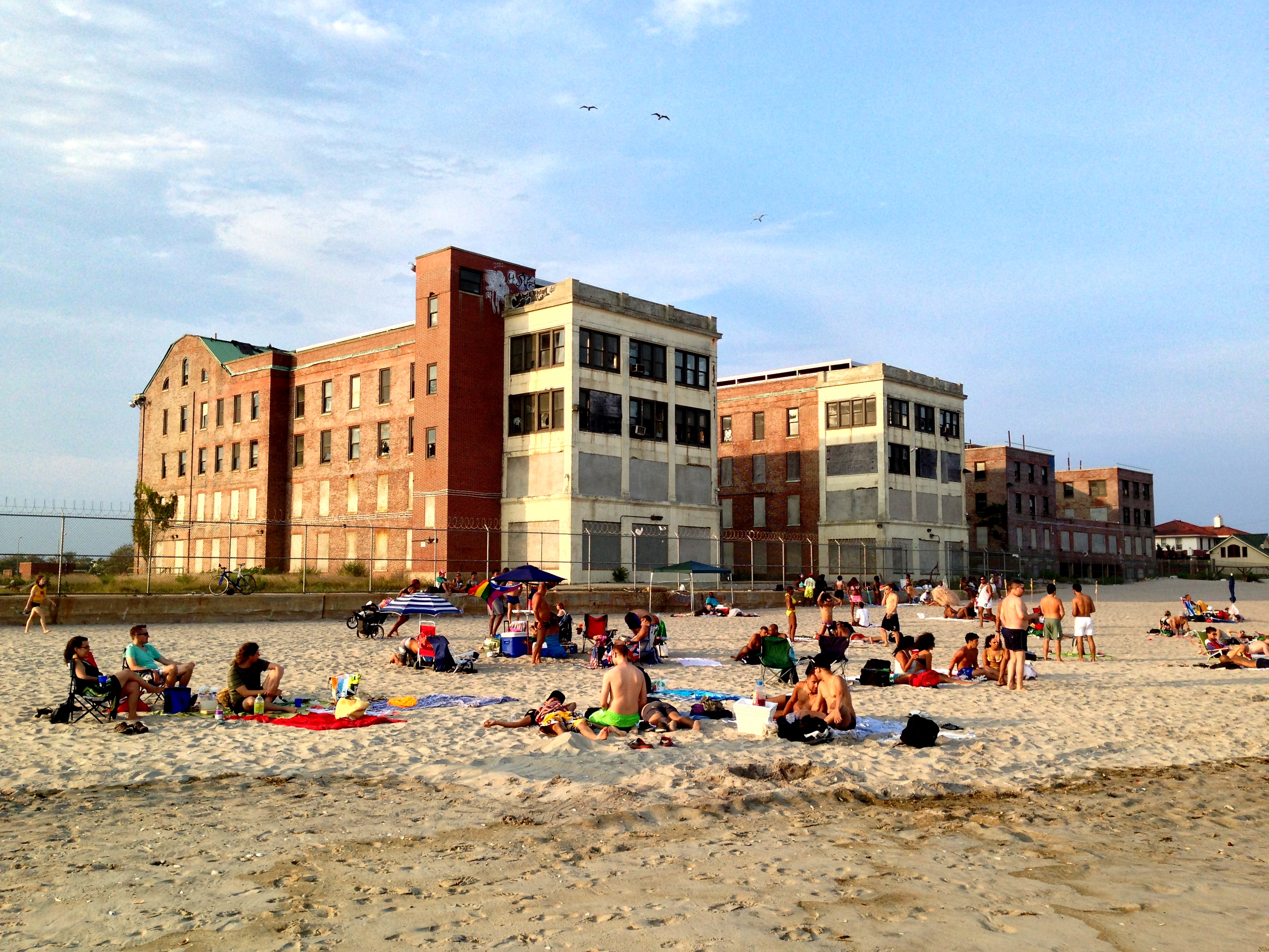
Jacob Riis Park.jpg

New York, US

Jacob Riis Park Beach

A Moses-era civic beach whose far eastern bays became the oldest gay beach in New York, claimed since the 1940s.

Jacob Riis Park.jpg · You may select the license of your choice. · CC BY-SA 3.0
Substrate
sand
Spring tide
1.51 m
Nearest airport
JFK · 12 km
Tier
Featured
I’m here for
Story

Jacob Riis Park is a 262-acre Atlantic beach on the Rockaway Peninsula in Queens, named in 1915 for Jacob Riis, the police reporter and photographer whose 1890 book How the Other Half Lives forced the tenement poverty of Lower Manhattan into public view. The city condemned the land in 1912 and named the park for him a year after his death. The sand is ordinary lithic-rich glacial and river sediment; the surf averages 0.94 meters. None of that is why the place matters. It matters for what was built on it and who it ended up belonging to.

What was built is a civic monument to the idea that a working-class city deserved a grand day at the ocean. The bathhouse, opened August 6, 1932 and expanded by Robert Moses's Parks Department in 1936 and 1937, is a long colonnaded brick building with twin octagonal towers, designed under chief Parks architect Aymar Embury II in stripped New Deal Art Deco. Behind it sit the Central Mall buildings of 1936 to 1937, a street clock from 1941, and a 15,000-car lot poured in a great curve to bring the masses by automobile — public design on the assumption the state should build beauty for everyone.

The everyone included people the design never planned for. The isolated eastern bays, around Bay 1 and Bay 2, have been a documented gathering and cruising ground for gay men since the 1940s, drawing lesbians by the 1950s and a Black and Latino LGBT presence by the 1960s. A 1963 New York Times feature listed it among the summer spots a gay New Yorker could find; the area picked up the nickname Screech Beach. In 1971 the post-Stonewall Gay Activists Alliance ran a voter registration drive on the sand. Generations have called the eastern bays the People's Beach.

The park went federal on March 4, 1974, folded into Gateway National Recreation Area, created in 1972. Federal stewardship did not save the bathhouse. Used into the 1970s and then left to decline, it saw a 1990s restoration stall before Hurricane Sandy's surge burst through it in October 2012, taking out doors, windows, and a courtyard wall. For decades the colonnade stood half-shuttered behind chain-link.

What surrounds it is its own catalog of New York left to rot. Just east stood the Neponsit Beach Hospital, a McKim, Mead & White tuberculosis sanatorium from 1915, later a nursing home emptied in 1998 and abandoned until its 2023 demolition; Floyd Bennett Field, the city's first municipal airport, sits adjacent. The beach itself erodes faster than it can be refilled. Riis today is a landmarked civic ruin, a contested queer sanctuary, and a public ocean beach on one stretch of sand, not at peace with itself.

The spike

A Moses-era civic beach whose far eastern bays became the oldest gay beach in New York, claimed since the 1940s.

Most legendary beaches are legendary for something nature did: a reef, a cliff, a break, a color of sand. Jacob Riis Park is legendary for an argument about who public space is for, and the beach has been living out both sides of that argument for almost a century. It is a Robert Moses civic monument built to hand the ocean to the working class, and it is the oldest gay beach in New York, claimed at its eastern edge by people the monument was never designed to welcome. The spike is that both things are true on the same sand, and the second has outlasted the first.

Start with the monument. By the early 20th century, reformer Jacob Riis had spent his career arguing that the tenement poor deserved light, air, and relief from a city that gave them none of it; How the Other Half Lives, published in 1890, was the photographic case for it. When the city condemned this Rockaway oceanfront in 1912 and named the park for him in 1915, the gesture was explicit: a grand beach for the people Riis had documented. Robert Moses made the gesture concrete. His Parks Department built the bathhouse that opened on August 6, 1932, and expanded it across 1936 and 1937 with the Central Mall buildings, all under chief architect Aymar Embury II, in the same lean, confident Art Deco Moses used across the New Deal city. The materials were serious — brick, limestone, granite — and so was the scale: a 40,000-square-foot bathhouse with twin octagonal towers, a colonnaded mall, a street clock installed in 1941, and a parking lot curved to hold 15,000 cars so the masses could drive to their day at the sea. This was civic design as a statement that the state should build beauty for ordinary people and trust them with it.

Now the part Moses did not plan. A monument built for the public gets used by the actual public, including the parts of it the planners would rather not picture. The far eastern end of the beach, around Bay 1 and Bay 2, is the most isolated stretch, screened for decades by dunes and by the bulk of the abandoned Neponsit hospital. By the 1940s it had become a documented destination for gay men to sunbathe and cruise, the oldest such site in the city. Women claimed a nearby patch by the 1950s; by the 1960s the crowd had broadened to include Black and Latino LGBT New Yorkers. A 1963 New York Times article named it among the places a gay man could go. The activist bookseller Craig Rodwell recalled that around 1962 police harassed gay men there with citations over the supposed size of their swimsuits — the state that built the beach also policing who got to relax on it. The community held the ground anyway, gave it a name, Screech Beach, and turned it political: in 1971 the post-Stonewall Gay Activists Alliance ran a voter registration drive on this exact sand. Across eighty years it has been called the People's Beach, a claim on Riis's own word for the place.

The two stories collide over the bathhouse and over the dunes. The park went federal on March 4, 1974, absorbed into Gateway National Recreation Area, the National Park Service unit created in 1972. The NPS did not maintain Moses's monument; the bathhouse was used into the 1970s and then abandoned, a 1990s restoration stalled half-finished, and Hurricane Sandy burst through it in October 2012, tearing out doors, windows, and the courtyard wall. So the civic-monument half of the spike spent decades as a shuttered ruin behind chain-link — the grand New Deal gesture, defunded and left to the salt air. Meanwhile the queer half kept the eastern bays alive without any monument at all, because what made the People's Beach was never the architecture. It was the distance from the parking lot, the screen of the dunes and the old hospital, and the agreement among the people who came that this was theirs.

The modern chapter puts both halves under pressure at once. In October 2022 the NPS signed a 60-year lease with a private developer (Bathhouse Lodge LLC, doing business through CBSK Developers and Brooklyn Bazaar) for a roughly $50 million restoration of the 1932 bathhouse — restaurants, a bar, a pool, event spaces, and 28 hotel rooms. Restoring the monument means privatizing a slice of the most explicitly public beach Moses ever built, and the people of the People's Beach can read the bill: a place built for those who could not afford the Hamptons, getting a hotel. At the same time the city demolished the abandoned Neponsit hospital in 2023, removing the wall of brick that had screened the queer beach from view for generations. And the sand itself is leaving: a 2023 replenishment poured roughly 360,000 cubic yards onto the shore, much of which has already washed back out, with erosion forcing periodic closures of Bay 1 and Bay 2 — the exact bays the community depends on.

That is the spike, and it is sharper than a pretty coastline. Jacob Riis Park is the place where a reformer's name, a master builder's monument, and a marginalized community's eighty-year occupation all sit on one eroding beach. Moses built a temple to public leisure and the public took him at his word more completely than he intended; the temple decayed while the people it half-excluded held the eastern bays through harassment, federal indifference, a hurricane, and now a hotel. The reef beaches keep their reef. Riis keeps an argument — about who the ocean belongs to — that it has never finished having.

Riis Landing jeh.JPG
Culture

Where it shows up

Literature
  • How the Other Half Lives · 1890
    Jacob Riis

    Riis's photographic exposé of tenement poverty in New York, the work that made the reformer's name and led the city to attach it to this beach in 1915.

History
  • The People's Beach

    The long-standing name for the eastern bays (Bay 1-2), an LGBTQ gathering ground since the 1940s and one of the most significant queer public spaces in the United States, with documented Black and Latino LGBT use by the 1960s.

  • Gay Activists Alliance voter registration drive · 1971
    Gay Activists Alliance

    The post-Stonewall GAA held a voter registration drive on the beach in 1971, an early use of the site for organizing rather than leisure.

NYC Transit Grumman Flxible 870 236.jpg
History

What happened here

  1. 1890cultural

    How the Other Half Lives published

    Jacob Riis publishes his photographic study of New York tenement poverty, the work that makes his name and, decades later, gives the park its namesake.

    Wikipedia →
  2. 1915founding

    Park named for Jacob Riis

    The city renames the Rockaway oceanfront park Jacob Riis Park on January 4, 1915, a year after the reformer's death; the land had been condemned in 1912.

    Wikipedia →
  3. 1932construction

    Bathhouse opens

    The brick bathhouse with its twin octagonal towers opens August 6, 1932, the centerpiece of the new civic beach.

    Wikipedia →
  4. 1937construction

    Moses-era expansion and Central Mall

    Robert Moses's Parks Department, under chief architect Aymar Embury II, expands the complex and builds the Art Deco Central Mall buildings across 1936-1937.

    Wikipedia →
  5. 1963cultural

    Named as a gay summer spot

    A New York Times feature lists the eastern end of Riis Park among the summer places a gay New Yorker could find, documenting a use that dated to the 1940s.

  6. 1971cultural

    Gay Activists Alliance voter drive

    The post-Stonewall Gay Activists Alliance runs a voter registration drive on the beach, marking the eastern bays as a site of organizing, not just leisure.

    Wikipedia →
  7. 1974transfer

    Transferred to the National Park Service

    The park is transferred to the federal government on March 4, 1974, becoming part of Gateway National Recreation Area, created in 1972.

    Wikipedia →
  8. 2012disaster

    Hurricane Sandy guts the bathhouse

    Sandy's storm surge bursts through the long-neglected bathhouse, tearing out door and window coverings and knocking down a courtyard wall; the park reopens in May 2013.

    Wikipedia →
  9. 2023demolition

    Neponsit hospital demolished; sand pumped on

    The abandoned Neponsit Beach Hospital next door is demolished, removing the screen that hid the queer beach, while roughly 360,000 cubic yards of replenishment sand are added against ongoing erosion.

    Wikipedia →
The honest part
Moses built a temple to public leisure; the National Park Service let it rot, and the people it half-excluded held the eastern bays through harassment, a hurricane, and now a hotel.

The romance of Jacob Riis Park has to be set against what is physically true of it. The 1932 bathhouse, the centerpiece of the whole civic gesture, spent the better part of four decades as an abandoned, vandalized ruin behind fencing — the National Park Service let a New Deal landmark rot, a 1990s restoration was abandoned half-done, and Hurricane Sandy gutted what was left in October 2012. The beach is eroding faster than it is being refilled; the 360,000 cubic yards of sand pumped on in 2023 are already washing away, and the erosion keeps closing Bay 1 and Bay 2, the very bays at the heart of the People's Beach. It is also genuinely hard to reach without a car: there is no subway to the park, the bus ride from the nearest train is long, and on hot weekends the curved 15,000-car lot fills and the access roads back up. Lifeguards are seasonal, the surf produces rip currents, and this is a low-lying ocean spit at the front edge of a rising sea.

And the deepest tension is human, not coastal. The eastern bays were held for eighty years by gay, trans, and Black and brown New Yorkers precisely because the place was out-of-the-way, screened, and unprofitable — qualities that are now being undone in the name of improvement. The 2023 demolition of the Neponsit hospital tore down the literal wall that hid the queer beach. The $50 million bathhouse lease, with its bar, pool, and 28 hotel rooms, threatens to price the People's Beach out of the People's Beach. Restoring Robert Moses's monument and protecting the community that gave the sand its meaning are not obviously the same project, and the people who use Bay 1 know it.

Jacob Riis Park td (2018-08-03) 019.jpg
Anatomy

The shape of the place

Western bays toward Fort Tilden

15%

The quieter western end of the bays running toward Fort Tilden and the Marine Parkway Bridge, away from the bathhouse crowd.

Best for a less packed stretch, a walk toward Fort Tilden

Fort Tilden, a former coastal-defense site, continues west; its beach is even less developed.

Bathhouse & Central Mall (central bays)

50%

The civic heart: the 1932 brick bathhouse with its twin octagonal towers, the 1936-1937 Art Deco mall, and the densest family crowds off the buses and the big lot.

Best for families, the architecture, seasonal concessions

The bathhouse is under a ~$50M restoration (Oct 2022 lease) adding restaurants, a bar, a pool, and 28 hotel rooms.

The People's Beach (Bay 1-2, eastern end)

90%

The isolated eastern bays toward Neponsit — the oldest gay beach in New York, a Black, brown, and queer gathering ground for eighty years. Little food service; bring your own. Periodically closed by erosion.

Best for the LGBTQ community, a self-organized day away from the central crowds

Screened for generations by dunes and the old Neponsit hospital, which was demolished in 2023.

Landmarks

Jacob Riis Park Bathhouse · 1932

bathhouse · Aymar Embury II, under Robert Moses (NYC Parks)

Long colonnaded brick bathhouse with twin octagonal towers, roughly 40,000 square feet, opened August 6, 1932 and expanded 1936-1937 in stripped Art Deco. Abandoned and gutted by Hurricane Sandy; now under a ~$50M restoration adding a hotel.

Wikipedia →

Riis Park street clock and Central Mall · 1941

monument · NYC Parks, Robert Moses era

The Art Deco Central Mall buildings (1936-1937) and the street clock installed in 1941 anchor the civic promenade behind the bathhouse, the formal spine of Moses's design.

Wikipedia →

Neponsit Beach Hospital (demolished 2023) · 1915

ruin · McKim, Mead & White

A children's tuberculosis sanatorium from 1915, later a nursing home emptied in 1998, then a notorious abandoned shell next to the park. Its bulk screened the eastern queer beach until it was demolished in 2023.

Wikipedia →
A day here

From first light to dark

Dawn

Before the lots open the beach belongs to surfcasters, runners on the cracked promenade, and gulls on the tide line; on a low spring tide the sand runs out wide and flat below the dark, shuttered octagonal towers of the bathhouse.

Midday

By early afternoon on a hot July day the curved 15,000-car lot fills, the central bays pack with families off the Q35 bus, and the eastern walk toward Bay 1 fills with the People's Beach crowd; the Atlantic, near 28°C air and averaging under a meter of swell, is warm enough to wade and sandbar-hop.

Golden hour

Late light turns the faded brick of the colonnade and the towers orange and rakes across the dune grass; the incoming tide narrows the beach and pushes everyone up toward the promenade and the old mall buildings.

Night

After dark the bays empty fast and the unlit bathhouse stands as a black silhouette against the city glow; with no boardwalk amusements and limited transit, the place goes quiet in a way a Coney Island never does.

Compare

How it ranks

Peak warmth
Cooler than 51% of beaches in its country
Peak-month high ≈ 28°C

Ranked against every beach in our database — 228,000+ worldwide.

CHILDREN AT THE BEACH IN REIS PARK, BROOKLYN, NEW YORK CITY THE INNER CITY TODAY IS AN ABSOLUTE CONTRADICTION TO THE... - NARA - 555923.tif
Sea & surf

What the water does

JFMAMJJASONDmetres (significant wave height)

Solid = typical monthly wave height; pale = the bigger days (90th pct). Offshore/regional swell from Open-Meteo Marine (ERA5 Ocean reanalysis, 2023–2024); a sheltered cove may sit calmer than this.

Mixed — usually swimmable, with a livelier season
Typical wave height
0.94 m
Biggest swell
Mar · 1.12 m
Calmest
Jul · 0.74 m
Typical period
8.2 s (groundswell)
Before you go

Things to know

There is no subway — plan the trip

No train reaches the park. Most people drive to the curved lot (which fills on hot weekends) or take the Q35 bus, which connects from the 2/5 at Flatbush Avenue in Brooklyn; from the Rockaway A-train, a transfer or a longer ride is needed. Access friction is real.

Lifeguards are seasonal; rips are real

The city/NPS staff lifeguards in summer only; outside that window there is no coverage. This is the open Atlantic with rip currents — swim near a staffed station and watch posted flags.

The eastern bays can be closed by erosion

Bay 1 and Bay 2, the People's Beach, are periodically shut by erosion despite the 2023 sand replenishment. Check current bay closures before heading specifically to the eastern end.

Food is seasonal and clustered — bring your own

On-beach food runs near the bathhouse in season; the eastern People's Beach has little to none. Coolers and your own supplies are the long-standing norm, especially at Bay 1-2.

Sharks

No incidents on record in the global shark-attack file.

Plan

If you go

Getting there
Nearest airport
John F. Kennedy International Airport (JFK) · 12 km
Nearest town
East New York · 11 km

There is no subway station at Jacob Riis Park, which is the single biggest access fact. Driving is most common: the Marine Parkway-Gil Hodges Memorial Bridge feeds the curved 15,000-car lot, which fills on hot summer weekends. By transit, the Q35 bus runs from the 2 and 5 trains at Flatbush Avenue-Brooklyn College straight to the park; from the A train's Rockaway branch you can connect by bus or walk east along the peninsula. From John F. Kennedy International Airport, about 12 km away, it is a car ride of roughly 25 to 40 minutes depending on traffic.

When to go
  • Summer LGBTQ gatherings at the People's Beach · Summer weekends, eastern bays (Bay 1-2)

    The eastern bays remain a self-organized weekend gathering ground for LGBTQ New Yorkers, especially queer and trans people of color, continuing a use documented since the 1940s. There is no single official organizer; the crowd makes the day.

What to eat & drink
Riis Park Beach Bazaar concessions

Seasonal food-and-drink concessions have run on the bathhouse forecourt and parking area under the Brooklyn Bazaar / Bathhouse operation — tacos, lobster rolls, frozen drinks, and a beer garden in summer. This is event-driven seasonal food, not a permanent restaurant row, and it is tied to the same operator now restoring the bathhouse.

Bathhouse forecourt / Bay 9-14 area, Jacob Riis Park (seasonal)

Rockaway Beach taco and surf-shack scene

A few minutes east along the peninsula, the Rockaway Beach boardwalk has the area's denser, more reliable food: fish tacos, arepas, pizza, and coffee aimed at the surf crowd. Far more options than Riis itself offers on the sand.

Rockaway Beach boardwalk, around Beach 86th to Beach 97th Street

Pack your own

Honestly, the most dependable food at Riis is what you carry in. The on-beach options are seasonal and concentrated near the bathhouse; the eastern People's Beach has little to no food service, and groups have long brought their own coolers, grills, and drinks to the dune end.

Bay 1-2 (the People's Beach), eastern end

Sources & references
  1. NYC LGBT Historic Sites Project · cited 3×
  2. Village Preservation; Living New Deal · cited 2×
  3. Jacob Riis Park, Wikipedia; NPS · cited 2×
  4. How the Other Half Lives, Wikipedia
  5. Jacob Riis Park, Wikipedia; NYC Parks
  6. Jacob Riis Park, Wikipedia; Living New Deal
  7. Architect's Newspaper; reporting on Hurricane Sandy
  8. ABC News; Untapped New York; Neponsit Beach Hospital, Wikipedia
  9. National Park Service, Gateway National Recreation Area; Jacob Riis Park, Wikipedia
  10. Jacob Riis Park, Wikipedia; NYC Parks history
  11. Jacob Riis Park, Wikipedia; Village Preservation; Living New Deal
  12. NPS news release; Architect's Newspaper; 6sqft
  13. Open-Meteo Marine (ERA5 reanalysis, 2023-2024)
Colophon · Provenance

Where this page comes from

Geography, facilities
OpenStreetMap (ODbL) for geometry and facility tags within 500 m of the beach centroid. GeoNames for city/airport distances.
Climate & ocean
worldclim_v2.1_2.5m
Tides
eot20
Photography
Archival, original tone (Tier B — Wikimedia Commons). Each image licensed per its own terms; attribution visible inline.
History & culture
Every factual claim is linked to its source in the prose above. Wikipedia citations inline. Non-wiki sources named where relevant.
Editorial voice
Register: melancholic. Written to pass a local's nod test; corrections welcome.
Written by Erin Rose
Last reviewed 2026-04-19
v0.9in editorial development toward v1.0