Ceara, BR

Jericoacoara Beach

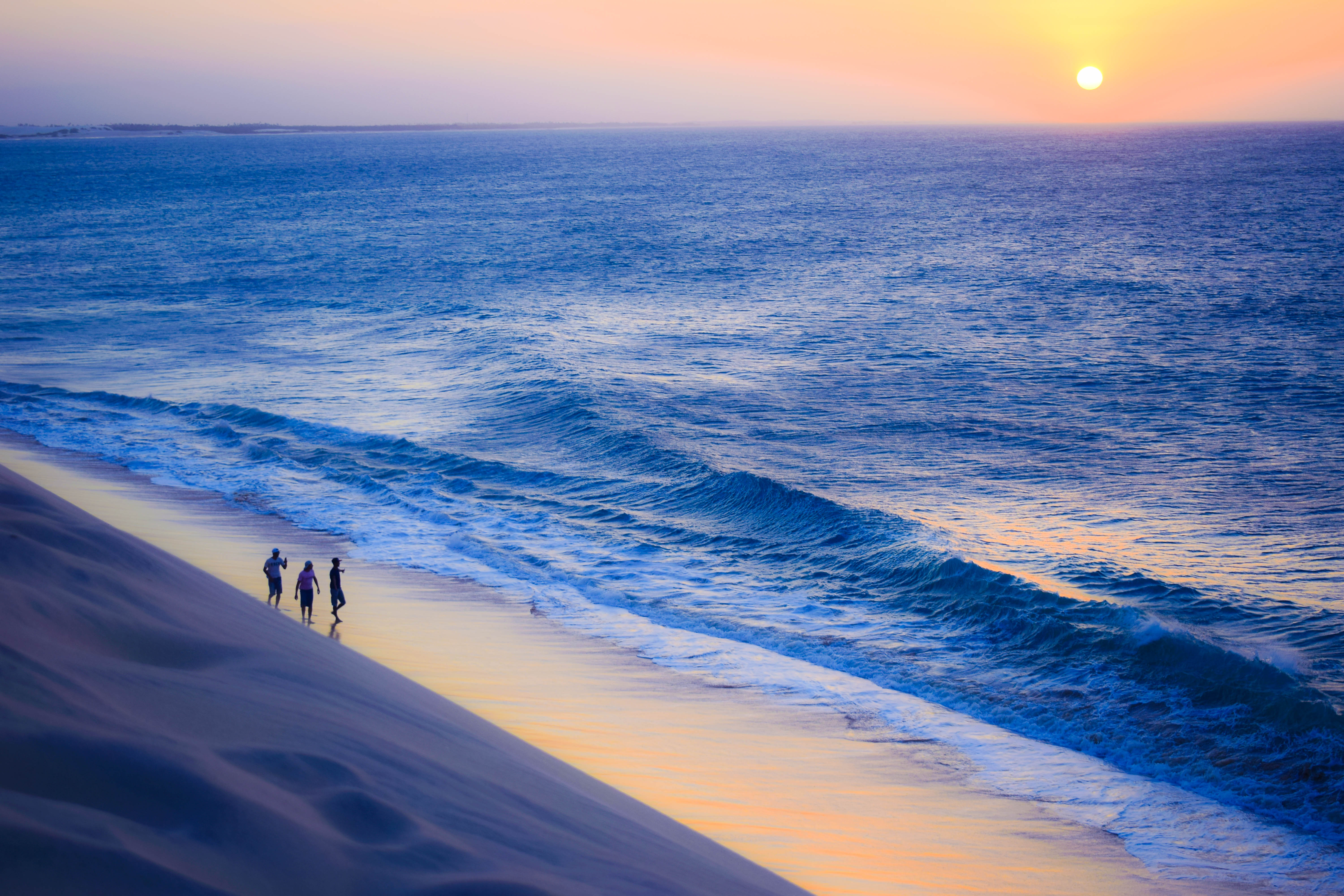
Imensidão do mar vista da Duna do Pôr do Sol - Praia de Jericoacoara.jpg

Ceara, BR

Jericoacoara

An off-grid Tupi fishing village a 1994 newspaper turned into a kitesurf capital, still road-less by law.

Imensidão do mar vista da Duna do Pôr do Sol - Praia de Jericoacoara.jpg · <a href="//commons.wikimedia.org/w/index.php?title=User:Wanessa_Gabrielle&amp;action=edit&amp;redlink=1" class="new" title="User:Wanessa Gabrielle (page does not exist)">Wanessa Gabrielle</a> · CC BY-SA 4.0
Spring tide
2.81 m
Nearest airport
JJD · 22 km
Tier
Featured
I’m here for
Story

Jericoacoara is a village on the northwest coast of Ceará, Brazil, where the streets are sand and no road reaches it. The last leg of the trip is run in 4x4 vehicles that drive directly over the dunes from Jijoca, roughly 45 minutes across loose sand. The name comes from Tupi and means "lair of turtles"; sea turtles still nest on these beaches.

For most of its history Jeri was a fishing village with little contact with the outside world. Electricity arrived in 1998, generated until then by diesel engines, and the village still bans electric street lighting by local ordinance, so the sky over the dunes stays dark. In 1984 the surrounding land was declared an Environmental Protection Area, and on 4 February 2002 it became Jericoacoara National Park, about 8,850 hectares run by the federal conservation agency ICMBio.

The turn came in 1994, when the Washington Post named Jericoacoara one of the ten most beautiful beaches on the planet. The village that had no road, no street money, and no grid became a destination. Tourism followed fast, and in June 2017 a regional airport, JJD, opened in the neighboring municipality of Cruz, 31 kilometers away, with direct flights from São Paulo and Belo Horizonte.

The coast itself is built for wind. Trade winds blow from roughly July through January, 20 to 35 knots, strongest from August to November, which made Jeri and the lagoons around it one of South America's main kitesurf and windsurf grounds. The sea off the main beach runs an annual mean wave of about 1.13 meters, peaking near 1.6 in September, with a spring tide range close to 2.8 meters.

Two landmarks anchor the place. The Duna do Pôr do Sol, the sunset dune, fills every evening with people climbing the sand to watch the sun drop into the Atlantic. West of the village stands Pedra Furada, a natural rock arch that is the park's official symbol; in July and August the setting sun lines up and drops straight through the hole in the stone.

The spike

An off-grid Tupi fishing village a 1994 newspaper turned into a kitesurf capital, still road-less by law.

Most famous beaches were made famous by something a place built: a hotel, a boulevard, a film studio nearby, a song. Jericoacoara was made famous by an absence and then nearly undone by it. The singular fact about Jeri is that it has no road, and that this is not an accident of remoteness but a condition the place has fought to keep even as it turned into a destination.

Start with how you arrive, because arrival is the whole argument. There is no paved road into Jericoacoara. You reach the town of Jijoca de Jericoacoara, and from there you transfer to a 4x4 that drives across open dunes for roughly 45 minutes, sand sliding under the tires the entire way. Inside the village the streets are sand too, and motor traffic is restricted, so you walk. This is not a themed pedestrian zone bolted onto a car town. It is the original condition of a fishing settlement that the giant mobile dunes kept cut off from the rest of Ceará for most of its existence.

That isolation was the entire culture. For generations Jeri was a fishing village with little contact with modern life — no roads, no grid, no telephones, money rarely used. The dunes that walled it off, dunes the national park later reported can migrate up to 30 meters a year, were the reason a traditional way of life survived intact on this stretch of coast longer than almost anywhere comparable. The geography that made Jeri hard to reach is exactly what made it worth reaching. Electricity did not arrive until 1998, and before that diesel engines ran what little power there was. Even now the village forbids electric street lighting by ordinance, which is why the dunes stay dark enough to see stars and why the sunset, rather than a bar, is the social event of the day.

Then came the sentence that changed everything. In 1994 the Washington Post named Jericoacoara one of the ten most beautiful beaches in the world. A village that had spent centuries being unreachable became, almost overnight, a thing people specifically wanted to reach. (The Post designation is well attested; the commonly cited 1994 date is reported by multiple travel sources but is not stated in the Wikipedia entry, which confirms the recognition without a year.) Tourism arrived faster than infrastructure, and the central tension of modern Jeri was set: a place whose entire appeal is its off-grid isolation now has to sell that isolation to people who fly in to consume it.

The coast then turned out to be world-class at something the fishermen never used it for. The trade winds here blow from roughly July to January, 20 to 35 knots, strongest from August through November, blowing on the great majority of days in that window. That made Jeri and the flat lagoons strung along the coast — Préa, Guriú, the lagoon-and-river system running west — into one of the planet's most reliable kitesurf and windsurf destinations. The local rule is itself telling: kitesurfing is forbidden directly off the main village beach, reserved for windsurfers, so kiters take a buggy to the lagoons or ride downwind. The wind that the village had simply lived with became its second economy.

The conservation response is the other half of the spike. In 1984 the surrounding land became an Environmental Protection Area; on 4 February 2002 it was elevated to Jericoacoara National Park, roughly 8,850 hectares administered by ICMBio, the federal biodiversity agency, expanded again in 2005. A national park wrapped around an inhabited village is an unusual arrangement, and it is the legal machinery that keeps the road out and the dunes from being built over. The name says what is being protected: Jericoacoara is Tupi for "lair of turtles," and sea turtles still nest on these beaches, especially where human pressure is lowest.

The two monuments of the place are not buildings. The Duna do Pôr do Sol is a dune people climb every evening to watch the sun set into the Atlantic — a daily ritual rather than an attraction with a ticket. Pedra Furada, the rock arch west of the village, is the park's official symbol, and in July and August the setting sun aligns and drops directly through the opening in the stone, which is why the trail there fills at exactly the wrong time for an easy walk back. Both are free, both are timed to the sun, and both reward the same thing the 4x4 demands: showing up in person, on the landscape's schedule, not your own.

What makes Jericoacoara singular, then, is not a single dune or a single arch. It is that the place is organized, legally and culturally, around staying hard to reach — sand streets, no grid lighting, a park that forbids the road — while a 1994 magazine line and a 2017 airport keep pulling the world toward it. The beach's defining feature is a contradiction it has not resolved and may not be able to.
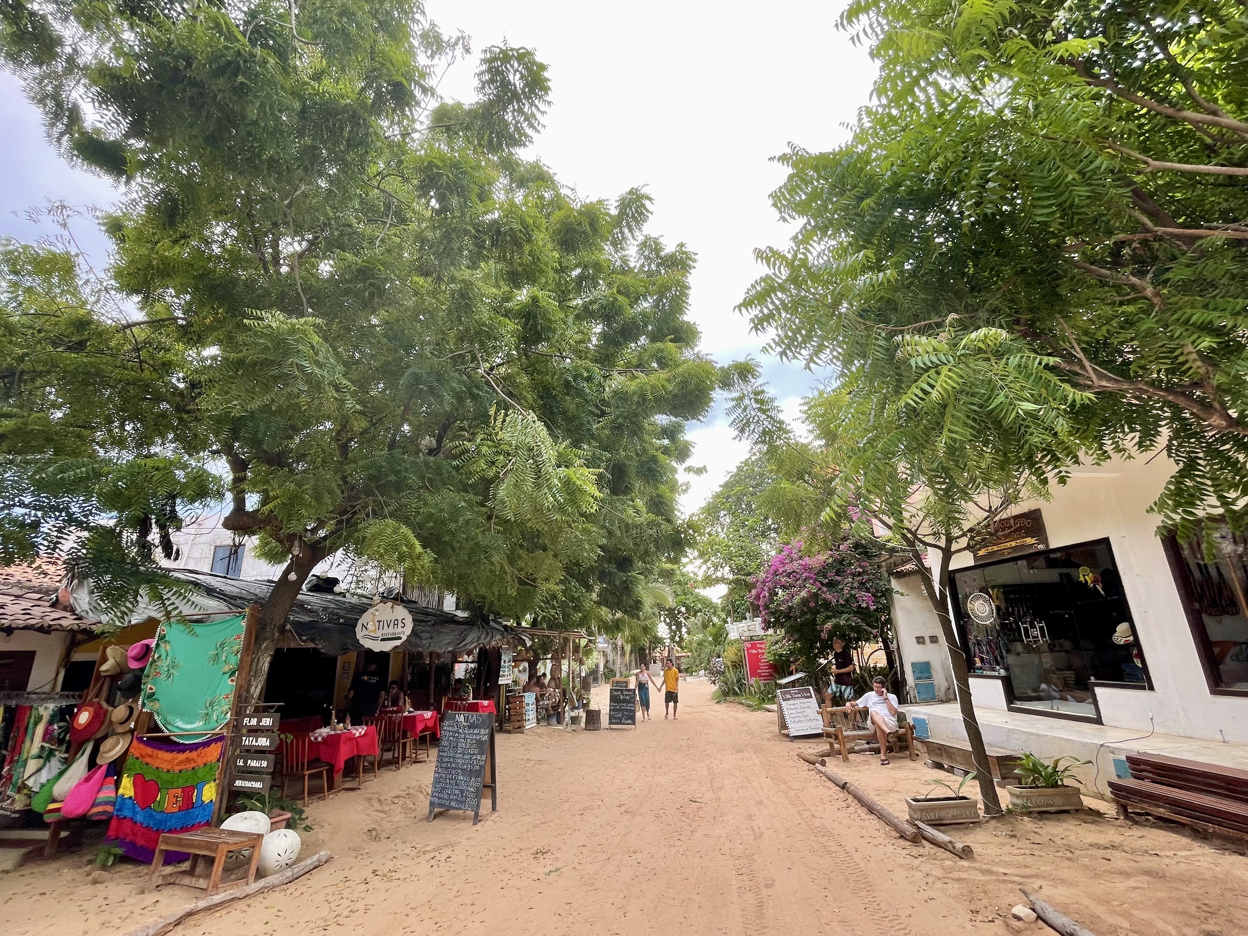
Jeri village3.jpeg
Culture

Where it shows up

History
  • Washington Post top-10 beaches · 1994
    The Washington Post

    The Washington Post named Jericoacoara one of the ten most beautiful beaches in the world. The 1994 date is widely reported by travel sources; the Wikipedia entry confirms the recognition without specifying a year. The designation is generally credited with launching the village's tourism era.

  • Vicente Yáñez Pinzón's 1499 anchorage · 1499

    Pinzón, a captain in Columbus's 1492 expedition, is recorded as anchoring in Jericoacoara's bay in 1499 — a landfall left unrecognized because the Treaty of Tordesillas was signed the same year.

Other
  • Tupi name: "lair of turtles"

    "Jericoacoara" comes from the Tupi language and translates as "lair of turtles." The name records the sea turtles that nest along this coast, the same wildlife the national park was later created to protect.

  • Kitesurf and windsurf destination

    Jericoacoara and the lagoons around it became one of South America's primary kitesurf and windsurf grounds on the strength of the July–January trade winds (20–35 knots, windiest August–November). The sport draws an international wind-chasing community to the village in the dry season.

Jeri5.jpeg
History

What happened here

  1. 1499historic

    Pinzón anchors in the bay

    Vicente Yáñez Pinzón, who had captained the Niña in Columbus's 1492 fleet, is recorded as anchoring in Jericoacoara's bay in 1499. The landing went unrecognized under the Treaty of Tordesillas signed that same year.

    Wikipedia →
  2. 1984political

    Environmental Protection Area declared

    The land around Jericoacoara is designated an Environmental Protection Area (APA), the first legal layer of protection over the dunes, lagoons, and fishing village.

    Wikipedia →
  3. 1994cultural

    Washington Post names it a top-10 beach

    The Washington Post names Jericoacoara one of the ten most beautiful beaches in the world. The 1994 date is reported by multiple travel sources; Wikipedia confirms the recognition without giving a year. Tourism to the road-less village accelerates afterward.

    Wikipedia →
  4. 1998infrastructure

    Electricity arrives

    Grid electricity reaches Jericoacoara for the first time, replacing diesel generators. The village retains a local ban on electric street lighting, keeping the dunes dark after sunset.

    Wikipedia →
  5. 2002political

    Jericoacoara National Park created

    On 4 February 2002 the area is elevated from protected area to national park — roughly 8,850 hectares of dunes, lagoons, mangrove, and beach, administered by the federal agency ICMBio.

    Wikipedia →
  6. 2005political

    Park boundary expanded

    The national park is enlarged, incorporating an additional 207 hectares into the protected area around the village and dune field.

    Wikipedia →
  7. 2017infrastructure

    Jericoacoara airport opens

    Comandante Ariston Pessoa Regional Airport (JJD/SBJE) is inaugurated on 24 June 2017 in the municipality of Cruz, 31 km from the village, with a 2,200 m runway. It connects Jeri directly to São Paulo and Belo Horizonte and sharply cuts the friction of arrival.

    Wikipedia →
  8. 2024economic

    Airport handles 221,818 passengers

    JJD records 221,818 passengers and 2,935 aircraft operations in 2024 — a measure of how far the once-isolated village's access has scaled since the airport opened.

    Wikipedia →
The honest part
Jericoacoara sells the very isolation that every plane, buggy, and pousada is steadily dismantling.

The off-grid village is partly a story sold back to the people who broke it. The same remoteness that the Washington Post praised in 1994 is what tourism has been steadily eroding ever since: a 4x4 still crosses the dunes, but it now carries a steady stream of visitors to a village whose population swells far beyond the fishing community that the isolation once protected. The 2017 opening of Jericoacoara airport, 31 kilometers away, cut the friction that used to keep numbers down — the friction was the point.

The national park is the load-bearing constraint and also the contested one. The dunes are mobile and fragile; buggies run daily across them to the lagoons; the lagoon-side hammock bars that fill Lagoa do Paraíso are a tourism industry operating inside a federal conservation unit. ICMBio's job is to hold a line between a living village, a fragile dune system that sea turtles nest in, and an economy that depends on bringing more people across both. That line is argued over, not settled.

Rio Guriú divisa Município de Camocim x Jericoacoara - panoramio.jpg
Anatomy

The shape of the place

Duna do Pôr do Sol

0%

The sunset dune at the west edge of the village. People climb the loose sand every evening to watch the sun set into the Atlantic; the climb is the ritual, and the dune fills before sundown.

Best for sunset, the climb, photography

Free; arrive 30–45 minutes early. Loose-sand climb of about 30 meters.

Praia Principal & village front

0%

The beach directly in front of the village, where the sand streets meet the sea. Fishing boats, windsurfers, and the day's foot traffic concentrate here. Kitesurfing is banned off this stretch — windsurf only.

Best for windsurfing, watching boats, village access

Inside the national park; no kitesurfing off the main beach by local rule.

Lagoa do Paraíso (inland)

1%

A freshwater lagoon about 10 km inland from the village, with hammocks strung over turquoise water and lagoon-side bars. Reached by buggy across the dunes; Lagoa Azul lies adjacent.

Best for flat-water lagoon days, hammocks, kitesurf launches

Not on the ocean; a buggy ride from the village. Inside the conservation area.

Pedra Furada arch

1%

A natural rock arch east along the coast, the official symbol of the national park. Reached on foot at low tide or by buggy. In July and August the setting sun aligns through the hole in the stone.

Best for the arch, low-tide walks, July–August sun alignment

Check the tide; the walk is only passable at lower water.

Landmarks

Pedra Furada

natural arch

A natural rock arch on the coast east of the village, eroded through by the sea, and the official symbol of Jericoacoara National Park. Reached on foot at low tide or by buggy; in July and August the setting sun aligns and drops directly through the opening, drawing photographers at exactly the hour that makes the walk back hardest.

Wikipedia →

Duna do Pôr do Sol

dune

The sunset dune at the western edge of the village. Each evening people climb roughly 30 meters of loose sand to watch the sun set into the Atlantic — a free, daily ritual that functions as the town's main social gathering, in part because the village bans electric street lighting and the dunes go dark afterward.

Wikipedia →

Jericoacoara National Park · 2002

national park · ICMBio (federal administration)

Created on 4 February 2002 from an earlier protected area, the park covers roughly 8,850 hectares of mobile dunes, freshwater lagoons, mangrove, and beach around the village, administered by the federal biodiversity agency ICMBio and expanded in 2005. Its name, Tupi for "lair of turtles," reflects the sea turtles that nest on these beaches.

Wikipedia →
A day here

From first light to dark

Dawn

The trade winds are lightest at first light, so dawn is the quiet window. Fishermen work the shore before the buggies start running; at low water the sand flats off the main beach widen and shorebirds — semipalmated plovers, ruddy turnstones, sandpipers — work the tide line. The village is still asleep; the sand streets are empty.

Midday

By late morning the wind is up and the lagoon traffic starts. Buggies leave for Lagoa do Paraíso, about 10 km away, where hammocks are strung over turquoise freshwater. On the ocean side the windsurfers are out off the main beach; the sand is hot and the village shade is in demand. Midday sun is intense this close to the equator, peak-month highs near 35°C.

Golden hour

Late afternoon is the strongest wind, often over 30 knots from August to November, and the kite lagoons are at their busiest. In the village, people start the climb up the Duna do Pôr do Sol. The dune fills shoulder to shoulder before sunset; the climb up loose sand is steep and slow, which is half the point.

Night

The sun drops into the Atlantic and the dune empties back into the sand streets. With no electric street lighting, the village is lit by pousadas, bars, and the sky. Capoeira circles and live forró music start up in the lanes off the main square; the wind usually drops after dark.

Compare

How it ranks

Peak warmth
Warmer than 99% of beaches in its country
Peak-month high ≈ 35°C
Worldwide
Among the warmest 2% of beaches on Earth

Ranked against every beach in our database — 228,000+ worldwide.

Jeri4.JPG
Sea & surf

What the water does

JFMAMJJASONDmetres (significant wave height)

Solid = typical monthly wave height; pale = the bigger days (90th pct). Offshore/regional swell from Open-Meteo Marine (ERA5 Ocean reanalysis, 2023–2024); a sheltered cove may sit calmer than this.

Mixed — usually swimmable, with a livelier season
Typical wave height
1.13 m
Biggest swell
Sep · 1.39 m
Calmest
Apr · 0.85 m
Typical period
6.8 s (wind chop)
Before you go

Things to know

There is no road in

You cannot drive a normal car to Jericoacoara. Reach Jijoca de Jericoacoara, then transfer to a 4x4 that crosses about 45 minutes of open dunes. Inside the village, streets are sand and motor traffic is restricted — you walk.

No electric street lighting

The village bans electric street lights by ordinance. After sunset the lanes are lit only by pousadas and bars. Bring a small light if you're walking the sand streets at night.

It is a national park, and the dunes are fragile

The whole area is a federal conservation unit run by ICMBio. The dunes are mobile and sea turtles nest on the beaches; stay on established routes, and treat buggy tours and lagoon trips as activity inside a protected area.

Kitesurfing is restricted off the main beach

Kitesurfing directly off the main village beach is forbidden — windsurfers only. Kiters take a buggy to the lagoons (Paraíso, Guriú) or ride downwind toward Préa. Wind season runs July–January, strongest August–November.

Sharks

No incidents on record in the global shark-attack file.

Plan

If you go

Getting there
Nearest airport
Comandante Ariston Pessoa Airport (JJD) · 22 km
Nearest town
Camocim · 38 km

There is no paved road to Jericoacoara. Most visitors fly into Fortaleza (about 300 km) or into the closer regional airport JJD (Comandante Ariston Pessoa), opened in June 2017 in the municipality of Cruz, 31 km away, with direct flights from São Paulo and Belo Horizonte. From either, you travel overland to Jijoca de Jericoacoara and transfer to a 4x4 that drives roughly 45 minutes directly over the dunes into the village. Inside Jeri the streets are sand and largely car-free, so you get around on foot; the inland lagoons and Pedra Furada are reached by dune buggy or, at low tide, on foot along the beach.

When to go
  • Duna do Pôr do Sol sunset gathering · Every evening before sunset

    Not a scheduled festival but a daily ritual: visitors and residents climb the sunset dune each evening to watch the sun set into the Atlantic. With electric street lighting banned in the village, it functions as the town's main nightly social event.

  • Pedra Furada sun alignment · July and August, at sunset

    For roughly two months in the Southern Hemisphere winter, the setting sun aligns with the natural arch of Pedra Furada and drops directly through the opening in the rock — the most photographed moment of the park's symbol.

What to eat & drink
Peixe à delícia

A Ceará coastal classic: white fish, often pescada or robalo, baked or grilled with banana, cheese, and a coconut-milk sauce. On a fishing coast this is the dish to order; Jeri's restaurants run on what the boats and trucks bring in.

Restaurants in Jericoacoara village (no kitchens on the beach itself)

Camarão (regional shrimp)

Ceará's coast is a major shrimp producer, and grilled or coconut-sauced shrimp appears on nearly every village menu. Prices reflect the haul-in cost of a road-less town — everything not caught locally arrives by truck and dune buggy.

Village restaurants around the Igreja and main sand streets

Tapioca

A folded crêpe made from cassava starch, a staple across Brazil's Northeast, sold sweet (banana, coconut, condensed milk) or savory (cheese, meat). Cheap, fast, and the reliable breakfast or beach snack when you don't want a full meal.

Kiosks and small eateries in the village

Caipirinha de caju

The Brazilian caipirinha made with caju (cashew fruit) instead of lime — cashew is a Northeast crop, and the local version leans on it. Served at the bars along the sand streets after the sunset-dune crowd comes down.

Bars off the main square, evenings

Sources & references
  1. wiki:Jericoacoara_National_Park · cited 5×
  2. wiki:Jericoacoara_Beach · cited 3×
  3. wiki:Comte._Ariston_Pessoa_Regional_Airport · cited 3×
  4. Washington Post Magazine, via multiple travel sources; year not confirmed in Wikipedia
  5. Washington Post Magazine, via multiple travel sources
  6. kitesurf location guides
  7. Open-Meteo Marine (ERA5), beach data file
  8. EOT20, beach data file
Colophon · Provenance

Where this page comes from

Geography, facilities
OpenStreetMap (ODbL) for geometry and facility tags within 500 m of the beach centroid. GeoNames for city/airport distances.
Climate & ocean
worldclim_v2.1_2.5m
Tides
eot20
Photography
Archival, original tone (Tier B — Wikimedia Commons). Each image licensed per its own terms; attribution visible inline.
History & culture
Every factual claim is linked to its source in the prose above. Wikipedia citations inline. Non-wiki sources named where relevant.
Editorial voice
Register: romantic. Written to pass a local's nod test; corrections welcome.
Written by Erin Rose
Last reviewed 2026-04-19
v0.9in editorial development toward v1.0