Chon Buri, TH

Jomtien

Jomtien Beach (11).jpg

Chon Buri, TH

Jomtien Beach

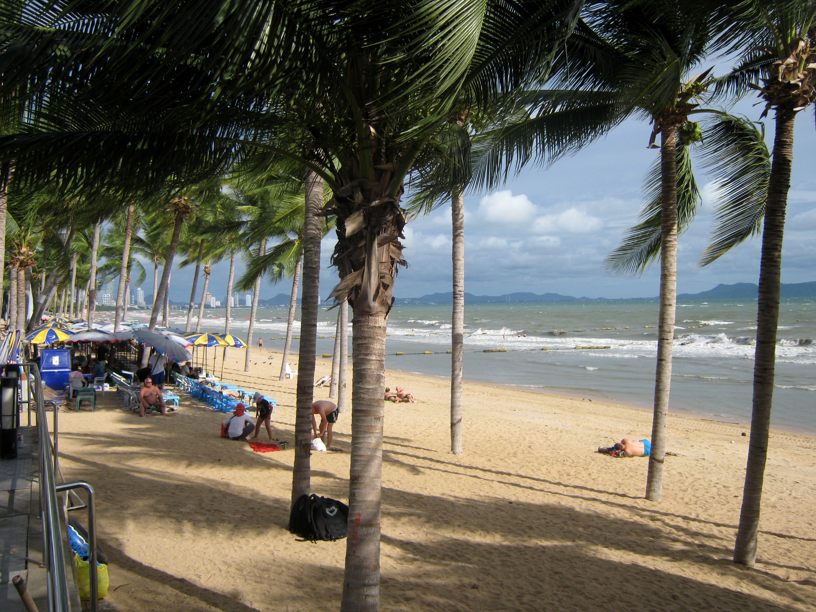
A straight 6-kilometre beachfront in Bang Lamung, 3 km south of Pattaya, where a wall of high-rise condominiums fronts the Gulf's busiest jet-ski strip.

Jomtien Beach (11).jpg · Георгий Долгопский · CC BY-SA 4.0
Nearest airport
UTP · 26 km
Tier
Featured
I’m here for
Story

Jomtien Beach runs for about 6 kilometres along the Gulf of Thailand in Bang Lamung District, Chonburi Province, roughly 3 km south of central Pattaya and about 165 km southeast of Bangkok. It is a straighter, longer, and generally quieter beachfront than the crescent of Pattaya Bay to the north, and it is fronted along almost its entire length by Jomtien Beach Road, a single street that separates the sand from a near-continuous wall of high-rise condominiums, hotels, and restaurants.

The beach exists in the shadow of Pattaya's history. Pattaya itself was a fishing village until the 1960s, when American servicemen on rest-and-recreation leave during the Vietnam War began arriving; one group is recorded as having come from a base at Korat on 29 June 1959, and word of mouth among US military personnel is widely credited with starting the tourism that reshaped the whole coast. Pattaya was granted city status on 29 November 1978. As that city filled and its bay grew crowded, development pushed south, and Jomtien became the overflow valve: a place with more sand, fewer go-go bars, and room for the condominium boom that gave it its present skyline. The Jomtien Complex, a real-estate development a block from the beach, anchors that growth.

The water is the draw and the catch. Jomtien is the area's principal watersports beach, with jet skis, parasailing, windsurfing, and scuba operators working the central stretch, and it has hosted Jet Ski World Cup events. The jet-ski trade is also the source of the most consistent warning attached to the area: foreign governments, including the UK's FCDO, advise visitors not to hand over passports as a rental guarantee, because operators have been documented alleging damage to returned craft and demanding payment before releasing documents.

The northern end connects to Pattaya's attractions — Thappraya Road climbs from the top of Jomtien Beach Road toward the Sanctuary of Truth, an all-wood temple complex begun in 1981 on the coast at Naklua, and toward Pattaya Park Tower above the beach's north end. The southern reaches, around Na Jomtien, are quieter and increasingly residential. The honest qualifier on all of it is the water: regional monitoring has repeatedly rated Pattaya-area seawater poor, and the coast's sewage-treatment capacity has long lagged behind the development crowding its shoreline.

The spike

A straight 6-kilometre beachfront in Bang Lamung, 3 km south of Pattaya, where a wall of high-rise condominiums fronts the Gulf's busiest jet-ski strip.

Jomtien's defining fact is not a single object but a line: about 6 kilometres of straight Gulf shoreline backed, almost without a break, by a wall of high-rise condominiums. To understand the beach you have to understand the wall, and to understand the wall you have to understand that Jomtien is what Pattaya overflowed into.

The geography of overflow. Pattaya was a fishing village until the 1960s. The Vietnam War turned it into a resort: American servicemen on rest-and-recreation leave began arriving — a group is recorded coming from a base at Korat on 29 June 1959 — and word of mouth among US military personnel started the tourism that reshaped the coast. Pattaya was granted city status on 29 November 1978. By then its crescent bay was filling fast, and growth had nowhere to go but south, over the headland of Phra Tamnak Hill and onto the next long beach. That beach was Jomtien: longer than Pattaya Bay, straighter, and crucially undeveloped. It became the relief valve, and the condominium boom that Pattaya's bay could no longer absorb landed here instead.

Why it built up the way it did. A straight 6-kilometre shoreline with a single road running its full length — Jomtien Beach Road — is, for a developer, an unusually clean canvas. Every tower gets the same west-facing sea view; every plot fronts the same road; the sand is a continuous amenity rather than a series of separate coves. So the towers went up in a near-continuous line, one street back from the water, and the Jomtien Complex and similar developments anchored a construction boom that has run for decades. The result is a beach with no real backshore. Where the sand ends, the road begins, and where the road ends, the high-rises begin. There is no dune, no forest, no buffer. The skyline is the landscape.

The watersports strip. What the wall faces is the busiest watersports water on the coast. Jomtien is where the jet skis, parasail boats, windsurfers, and dive operators concentrate; it has hosted Jet Ski World Cup events. This is the beach's signature and its single most-warned-about feature at once. The jet-ski rental scam attached to the Pattaya coast is specific enough that the UK's FCDO names it: do not hand over a passport as a rental guarantee, because operators have been recorded alleging that a returned craft was damaged and demanding large payments, holding the document for leverage. The activity that defines Jomtien is also the activity foreign governments warn their citizens about by name.

The Pattaya gravity well. Jomtien never fully separates from the city that produced it. Thappraya Road climbs from the northern end of Jomtien Beach Road toward Pattaya proper and toward the area's big draws — Pattaya Park Tower above the beach's north end, and, on the coast at Naklua, the Sanctuary of Truth, the all-wood temple begun in 1981 by businessman Lek Viriyaphan, its central spire 105 metres tall and its construction projected to finish no sooner than 2026. South of the centre, toward Na Jomtien, the towers thin and the beach goes residential and quiet. The beach is, in effect, a gradient: Pattaya's intensity at the north end, decompressing as you walk south.

The honest edge. The pitch for Jomtien is that it is the calmer, cleaner Pattaya. Calmer, mostly yes. Cleaner is the harder claim. Regional monitoring has repeatedly rated the seawater along this coast as poor, and the sewage-treatment capacity has lagged the relentless construction crowding the shoreline; runoff discolours the surf after heavy rain. So the spike, fully stated, is this: a 6-kilometre wall of condominiums facing the Gulf's busiest jet-ski strip over water that is not always as clean as the brochures imply — the most built, most active, and most candidly compromised long beach on the Pattaya coast.

Jomtien Beach (5841929757).jpg
Culture

Where it shows up

History
  • Vietnam-War R&R origins of the Pattaya coast · 1959

    The tourism that built the Pattaya–Jomtien coast began with American servicemen on rest-and-recreation leave during the Vietnam War, with a group recorded arriving from Korat on 29 June 1959 and credited with recommending the then-fishing village. Jomtien is a direct product of the southward sprawl that history set in motion.

Other
  • Russian and Scandinavian resident communities

    Jomtien hosts a large resident population of Russian and Scandinavian nationals, including two long-standing Norwegian communities, giving the beachfront a distinctly Eastern European and Nordic overlay alongside its Thai character.

  • The jet-ski scam as a coast-defining warning

    The Pattaya–Jomtien jet-ski rental scam is specific enough to appear in foreign-government travel advice, with the UK FCDO warning travellers not to surrender passports as rental deposits because operators have alleged damage and demanded payment. The warning has become part of how the area is described.

Pattaya Soi 7 Thailand.jpg
History

What happened here

  1. 1959cultural

    US servicemen reach Pattaya

    A group of American servicemen is recorded arriving from a base at Korat on 29 June 1959 and is credited with recommending Pattaya, beginning the Vietnam-War-era rest-and-recreation tourism that would reshape the whole coast, Jomtien included.

    Wikipedia →
  2. 1978policy

    Pattaya granted city status

    On 29 November 1978 the Thai government granted Pattaya city status, formalizing the resort that had grown from a fishing village through the 1960s and 1970s and whose southward sprawl produced Jomtien.

    Wikipedia →
  3. 1981construction

    Sanctuary of Truth construction begins

    Construction begins on the Sanctuary of Truth, an all-wood temple complex commissioned by businessman Lek Viriyaphan on the coast at Naklua north of Jomtien, with a central spire reaching 105 m. It remains under construction decades later.

    Wikipedia →
  4. 2026cultural

    Sanctuary of Truth nears completion

    Decades after its 1981 start, the Sanctuary of Truth is projected to be completed no earlier than 2026, with visitors already admitted inside wearing safety equipment. It remains the major cultural landmark anchoring the coast above Jomtien.

    Wikipedia →
The honest part
The activity that defines Jomtien is also the activity foreign governments warn their citizens about by name.

Jomtien is sold as the calmer, cleaner Pattaya, and on the first count it is largely true: the beach is longer, straighter, and less frenetic than the bay to the north. On the second count the record is mixed. Regional environmental monitoring has repeatedly rated the seawater along the Pattaya–Jomtien coast as poor, and the area's sewage-treatment capacity has struggled to keep pace with decades of high-rise construction crowding the shoreline. After heavy rain, runoff visibly discolours the surf.

The watersports that define the beach come with their own well-documented hazard. The jet-ski rental scam is specific enough that foreign ministries name it: the UK FCDO advises travellers not to surrender a passport as a rental deposit, because operators have been recorded claiming a returned jet ski was damaged and demanding large cash payments, holding the document as leverage. It is the single most reliable warning attached to the area, and it is attached precisely to Jomtien's signature activity.

Then there is the wall. The condominium towers that give Jomtien its skyline also define its character: the beach is a strip of sand backed not by dunes or forest but by Jomtien Beach Road and a near-unbroken line of high-rises. Whether that reads as convenience or as over-development depends on what you came for. What it is, unambiguously, is built.

Jomtien Beach (7).jpg
Anatomy

The shape of the place

South Jomtien / Na Jomtien

10%

The quieter southern reaches toward Na Jomtien, increasingly residential, with calmer beach sections, fewer vendors, and family-run accommodation. The skyline thins relative to the centre.

Best for A quieter, longer-stay beach base

Crowds and prices both ease moving south.

Central Jomtien watersports strip

45%

The busiest section, where jet skis, parasail boats, windsurfers, and dive operators work the water and sunbed vendors line the sand. Fronted by the densest run of Jomtien Beach Road restaurants and condo towers.

Best for Watersports and a lively beach day

The jet-ski rental scam is most associated with this kind of beachfront operator; never surrender a passport as a deposit.

Jomtien Beach Road

50%

The single street running parallel to the sand for the beach's full length, separating the shoreline from the wall of condominiums, hotels, and restaurants that define Jomtien's built character.

Best for Dining, sunbeds, and beach access

There is essentially no undeveloped backshore; the road and the towers begin where the sand ends.

North Jomtien / Pattaya border

90%

The transitional stretch where Jomtien Beach Road meets Thappraya Road and the city of Pattaya. More amenities than the south, with the climb toward Pattaya Park Tower and the route to the Sanctuary of Truth starting here.

Best for Access to Pattaya's attractions

Thappraya Road commences at the northern end of Jomtien Beach Road.

Landmarks

Sanctuary of Truth · 1981

temple · Lek Viriyaphan

An all-wood temple and museum complex begun in 1981 on the coast at Naklua, north of Jomtien, with a central spire reaching 105 m and construction projected to finish no earlier than 2026. Built from Mai Deang, Mai Takien, Mai Panchaat, and teak, it blends Thai, Hindu, Buddhist, Chinese, Khmer, and Burmese forms.

Wikipedia →

Pattaya Park Tower

tower

A high tower with a revolving restaurant and a tower-jump descent ride above the north end of Jomtien Beach, attached to the Pattaya Park complex and forming the most recognizable structure on the beach's skyline.

Jomtien Complex

development

A real-estate development a block from the beach, cited as an important anchor of the construction boom that produced Jomtien's high-rise condominium skyline.

Wikipedia →
A day here

From first light to dark

Dawn

At first light Jomtien Beach Road is nearly empty and the Gulf is flat, the long straight shoreline catching low sun from the east. Joggers and a few early swimmers have the 6 kilometres of sand mostly to themselves before the sunbed vendors set out their chairs and umbrellas.

Midday

By late morning the central stretch is working: sunbeds rented for the day, parasail boats towing canopies offshore, and jet skis running the water beyond the swim line. The heat is hard and the UV high; the condo wall behind the road throws little shade onto the sand itself.

Golden hour

Late afternoon is Jomtien's strongest hour. The sun drops toward the Gulf on the beach's west-facing line, the watersports operators wind down, and the sunbeds fill with people who waited out the midday heat. Vendors work the sand with grilled food and cold drinks.

Night

After dark the beach quiets and the action moves to Jomtien Beach Road and the weekend walking market, where food stalls and beer gardens run along the sois. The towers light up behind the palms, and the surf is audible over a far less raucous nightlife scene than central Pattaya's.

Before you go

Things to know

Jet-ski scam

Never hand a passport to a jet-ski or motorbike rental as a deposit; operators have alleged damage and demanded payment, per UK FCDO advice. Photograph any craft before riding.

Water quality

Regional monitoring has repeatedly rated Pattaya-area seawater poor; sewage capacity lags the development. Avoid swimming after heavy rain when runoff discolours the surf.

Beach access

The beach is free and public for its full 6 km; you pay only for sunbeds, food, and activities. Jomtien Beach Road runs the whole length.

Getting there

U-Tapao Airport (UTP) is about 40 km / a 50-minute drive; Bangkok's Suvarnabhumi is roughly 120 km, about 1.5 hours.

Sharks

No incidents on record in the global shark-attack file.

Plan

If you go

Getting there
Nearest airport
U-Tapao–Rayong–Pattaya International Airport (UTP) · 26 km
Nearest town
Phatthaya · 6 km

Jomtien sits about 3 km south of central Pattaya in Bang Lamung, Chonburi. U-Tapao International Airport (UTP) is about 40 km (a 50-minute drive); Suvarnabhumi Airport is roughly 120 km / 1.5 hours. Jomtien Beach Road runs the full length of the sand, with Thappraya Road climbing toward Pattaya at the northern end.

When to go
  • Jet Ski World Cup · Held periodically at Jomtien Beach

    Jomtien Beach has hosted Jet Ski World Cup events, reflecting its status as the principal watersports beach of the Pattaya coast.

  • Jomtien weekend walking market · Weekend evenings

    On weekend nights the central sois host a walking market of food stalls, clothing vendors, and beer gardens, the main evening draw on the Jomtien beachfront.

What to eat & drink
Grilled Gulf seafood

Whole grilled fish, prawns, and squid sold from beachfront restaurants and roving vendors along the sand — the standard Gulf-coast meal, priced higher on the beachfront than a block inland.

Jomtien Beach Road restaurants and beach vendors

Thai street food

Pad thai, grilled meats, sticky rice, and som tam from shophouses and stalls on the sois running inland from the beach, where Thai families eat for a fraction of beachfront prices.

Side sois off Jomtien Beach Road and near Sukhumvit Road

Jomtien weekend walking market

On weekend nights the central sois fill with food stalls, clothing vendors, and beer gardens — a tourist market where prices run fairer than the beachfront bars.

Central Jomtien, weekend evenings

Russian and Scandinavian cafes

Jomtien hosts a large resident population of Russian and Scandinavian nationals, including long-standing Norwegian communities, and the dining strip reflects it with Eastern European and Nordic menus alongside Thai food.

Jomtien Beach Road and inland blocks

Sources & references
  1. Wikipedia: Jomtien Beach · cited 6×
  2. Wikipedia: Pattaya · cited 3×
  3. Wikipedia: Sanctuary of Truth · cited 3×
Colophon · Provenance

Where this page comes from

Geography, facilities
OpenStreetMap (ODbL) for geometry and facility tags within 500 m of the beach centroid. GeoNames for city/airport distances.
Climate & ocean
Open-Meteo ERA5 + Marine archive, 2014–2023 monthly normals.
Photography
Archival, original tone (Tier B — Wikimedia Commons). Each image licensed per its own terms; attribution visible inline.
History & culture
Every factual claim is linked to its source in the prose above. Wikipedia citations inline. Non-wiki sources named where relevant.
Editorial voice
Register: wry. Written to pass a local's nod test; corrections welcome.
Written by Erin Rose
Last reviewed 2026-04-19
v0.9in editorial development toward v1.0