Lower Normandy, FR

Juno Beach

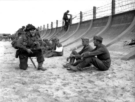
'Nan White' Beach, JUNO Area at Bernieres-sur-Mer.jpg

Lower Normandy, FR

Juno Beach

Canada's D-Day beach: ~340 Canadians killed on 6 June 1944, now a lifeguarded summer resort beach in front of the same German bunkers.

'Nan White' Beach, JUNO Area at Bernieres-sur-Mer.jpg · Post-Work: <a href="//commons.wikimedia.org/wiki/User:W.wolny" title="User:W.wolny">User:W.wolny</a> · Public domain
Length
800 m
Spring tide
6.61 m
Nearest airport
CFR · 18 km
Tier
Featured
I’m here for
Story

Juno Beach is an 8-kilometer stretch of the Calvados coast in Normandy, fronting the English Channel in front of three communes: Courseulles-sur-Mer at the west, Bernières-sur-Mer in the center, and Saint-Aubin-sur-Mer at the east. The name is not French. It is the Allied codename for the Canadian landing sector of 6 June 1944, and like the other D-Day beaches it has stuck so completely that the French use it too. Planners split the beach into two sectors, Mike in the west and Nan in the east, with Nan further cut into Green, White, and Red.

This was Canada's beach. Roughly 14,000 Canadians of the 3rd Canadian Infantry Division and the 2nd Canadian Armoured Brigade came ashore here, alongside British No. 48 (Royal Marine) Commando and the specialized armour of the British 79th Armoured Division. They landed against two battalions of the German 716th Infantry Division dug into the seafront. H-Hour was set for about 07:45, ten minutes later than the British beaches, because an offshore reef forced planners to wait for the rising tide to cover it. That delay had a cost: by the time the craft came in, the tide had climbed over the beach obstacles, and many landing craft grounded against the seawall directly under German fire.

The killing was fast. The 3rd Canadian Infantry Division lost 340 killed, 574 wounded, and 47 captured on D-Day, about 961 casualties in the Juno sector. The Queen's Own Rifles took the heaviest battalion losses, 143 men; one of its companies lost 65 in the first minutes at Bernières, landing in front of an intact pillbox. And then the Canadians pushed inland farther than anyone: by mid-afternoon they had advanced nearly 7 miles, deeper than any other Allied force that day.

The memory is held in concrete and steel along the seafront. At Courseulles stands the Juno Beach Centre, opened on 6 June 2003. At Bernières, a single seaside house above the sand, La Maison des Canadiens, "Canada House," was among the first buildings liberated. A short walk from these monuments, in July and August, the beach at Bernières and Saint-Aubin is supervised by lifeguards, families swim, and sand-yachts run the firm low-tide flat. Juno is two things on the same sand, and it has not resolved the contradiction so much as learned to carry it.

The spike

Canada's D-Day beach: ~340 Canadians killed on 6 June 1944, now a lifeguarded summer resort beach in front of the same German bunkers.

Most legendary beaches earn the word from nature: a reef, a wave, a cliff, a color of sand. Juno earned it in a single morning, and its singular, unresolved fact is the one it shares with the other D-Day beaches and states more plainly than most: this is the beach where Canada's army came of age and bled to do it, and it is now a working Norman seaside-resort beach with lifeguards and ice-cream kiosks a few steps from the bunkers. Both things are true of the same sand on the same August afternoon.

Start with the geography, because it set the price. Juno runs about 8 kilometers in front of three small resort towns, Courseulles-sur-Mer, Bernières-sur-Mer, and Saint-Aubin-sur-Mer, that were already seaside villages in 1944, with houses and a seawall directly above the sand. That matters: unlike Omaha, with its high bluffs, Juno is low and built-up, so the German defenders fired not from cliffs but from concrete strongpoints, blockhouses, and gun casemates set into the seafront itself, at the harbour mouth of Courseulles and behind the seawall at Bernières and Saint-Aubin. The Allies divided the beach into the Mike sector (west, at Courseulles) and the Nan sector (east, through Bernières to Saint-Aubin), Nan further split into Green, White, and Red. Those code-letters are still the grid on which the casualty reports are written.

The tide turned the plan against the men. An offshore shoal forced H-Hour at Juno back to roughly 07:45, about ten minutes later than the British beaches on either side, to let the rising tide cover the reef. The unintended result was that by the time the assault craft ran in, the tide had also climbed over the rows of mined beach obstacles the Germans had planted below the high-water line. Many craft struck those obstacles or grounded hard against the seawall, with almost no open sand to cross, which sounds merciful and was not: it put the leading companies a few meters from intact German positions that the pre-landing bombardment had failed to silence. At Bernières, B Company of The Queen's Own Rifles of Canada landed about 250 yards east of its aiming point, directly in front of a German pillbox, and took roughly 65 casualties in the first minutes before the survivors got over the seawall and into the town. The Queen's Own Rifles ended the day with 143 casualties, the worst of any battalion at Juno.

The numbers must be given carefully, because false precision dishonors them. On 6 June 1944 the 3rd Canadian Infantry Division at Juno suffered 340 killed, 574 wounded, and 47 taken prisoner, about 961 casualties in the sector. A higher, often-quoted figure of roughly 359 or 381 Canadians killed on D-Day comes from adding the airborne and air-force dead, the 1st Canadian Parachute Battalion and Royal Canadian Air Force losses, to the men killed on and just behind Juno; sources phrase this differently, so the honest version is that about 340 Canadians were killed on the Juno beachhead itself, and the larger numbers fold in other units elsewhere. Proportionally, Canadian losses on D-Day were among the heaviest of any Allied beach. Roughly 14,000 Canadians landed here, part of about 21,000 troops in the sector counting the British and supporting arms.

And then Juno did something the casualty count alone hides: the Canadians went the farthest. Despite the slaughter in the first waves, by mid-afternoon Canadian units had pushed nearly 7 miles (about 11 km) inland, deeper than any other Allied force on D-Day. The Queen's Own Rifles reached Anisy by last light. They did not seize all their objectives, the Caen-Bayeux road and Carpiquet airfield held out, and the gap with the British beach to the west left both flanks exposed to the German 21st Panzer Division, but no one got further. The beach that cost Canada its bloodiest morning of the war is also the beach from which Canadians advanced fastest into occupied France.

The memory along the seafront is dense and specific, not abstract. At Courseulles, on the sand where the Regina Rifles and Royal Winnipeg Rifles came ashore in the Mike and Nan-Green sectors, stands the Juno Beach Centre, Canada's D-Day museum, inaugurated on 6 June 2003 in the presence of Prime Minister Jean Chrétien and about a thousand Canadian veterans; it was driven by veteran Garth Webb and his association, who raised the money when no official body would. At Bernières, a tall seaside villa standing alone above the beach, La Maison des Canadiens, "Canada House," was among the first French houses liberated on D-Day, taken at first light by the Queen's Own Rifles; it appears in newsreel footage of the landing and is privately preserved as a memorial. Just west of Courseulles, at the boundary with Graye-sur-Mer, a giant steel Cross of Lorraine marks where General Charles de Gaulle stepped back onto French soil on 14 June 1944, eight days after the landing, his first return from exile, before going on to give his first speech of liberated France at Bayeux.

That is the spike, and it does not soften. You can stand at Bernières in August with children swimming and a sand-yacht crossing the flat, look up at Canada House on the seawall and the German bunker beside it, and understand that the calm resort beach in front of you and the worst morning of the Canadian army's war are not two places. They are one place, and the only honest way to be here is to hold both at once.

General De Gaulle landing place, Graye sur Mer, Calvados, Normandy, France.jpg
Culture

Where it shows up

History
  • La Maison des Canadiens newsreel footage · 1944
    Canadian Army Film and Photo Unit

    Bernières and its seawall villa, Canada House, were filmed by the Canadian Army Film and Photo Unit on 6 June 1944, making this one of the most-photographed stretches of the Canadian landing and a fixed reference point for the assault.

  • First Bayeux speech · 1944
    Charles de Gaulle

    After coming ashore at Courseulles on 14 June 1944, de Gaulle delivered his first speech on liberated French soil at nearby Bayeux, asserting Free French authority over the newly freed territory; the landing point is marked by the Cross of Lorraine.

Literature
  • Juno Beach: Canada's D-Day Victory · 2004
    Mark Zuehlke

    A detailed narrative history of the Canadian assault on Juno, widely cited for the regiment-by-regiment account of the landing and the advance inland.

Film
  • The Longest Day · 1962
    Darryl F. Zanuck (producer)

    The large-scale ensemble film of D-Day, based on Cornelius Ryan's book, covers the British and Canadian beaches among its sequences; for decades it was the standard cinematic account of 6 June 1944, though Juno receives less screen time than Omaha.

Plage Juno 2009.JPG
History

What happened here

  1. 1944battle

    The Juno Beach landing

    On 6 June 1944, ~14,000 Canadians of the 3rd Canadian Infantry Division and 2nd Canadian Armoured Brigade, with British No. 48 (RM) Commando and 79th Armoured Division armour, land across the Mike and Nan sectors at Courseulles, Bernières, and Saint-Aubin. H-Hour (~07:45) is delayed for the tide to cover an offshore reef; the rising tide also covers the beach obstacles, and craft ground against the seawall under fire. Canadian losses for the day: 340 killed, 574 wounded, 47 captured.

    Wikipedia →
  2. 1944military

    Canada House liberated at Bernières

    At first light on 6 June, the Queen's Own Rifles of Canada take the Bernières seafront, including the tall villa later known as La Maison des Canadiens ("Canada House"), among the first French houses liberated on D-Day. B Company had lost about 65 men in the first minutes against an intact pillbox just east of its aiming point.

    Wikipedia →
  3. 1944military

    Deepest Allied advance inland

    By mid-afternoon on 6 June, Canadian units have pushed nearly 7 miles (about 11 km) inland from Juno, farther than any other Allied force that day. The Queen's Own Rifles reach Anisy by last light. Carpiquet airfield and the Caen-Bayeux road, the day's full objectives, are not taken.

    Wikipedia →
  4. 1944historic

    De Gaulle returns to French soil

    On 14 June 1944, eight days after the landing, General Charles de Gaulle comes ashore at Courseulles-sur-Mer from the Free French ship La Combattante, his first return to French soil since exile, then travels to Bayeux to give his first speech of liberated France. A steel Cross of Lorraine at the Graye-sur-Mer boundary marks the spot.

    Wikipedia →
  5. 1944military

    Carpiquet and the road to Caen

    The Juno-sector objectives left unmet on D-Day, including Carpiquet airfield, are taken only in hard fighting through July 1944 as the Canadians grind toward Caen, part of the wider Battle of Normandy that lasted into August.

    Wikipedia →
  6. 1984memorial

    Canada House preserved as a memorial

    La Maison des Canadiens at Bernières-sur-Mer, photographed on D-Day and in newsreel footage of the landing, is preserved by its private owners as a memorial to the Queen's Own Rifles and the Canadians who liberated it, a fixed point for veterans returning to the beach.

  7. 2003memorial

    Juno Beach Centre opens

    Canada's D-Day museum, the Juno Beach Centre, opens at Courseulles-sur-Mer on 6 June 2003, inaugurated with Prime Minister Jean Chrétien and about a thousand Canadian veterans. It was driven by veteran Garth Webb and his association to commemorate the Canadians who served in the liberation of Europe.

    Wikipedia →
  8. 2019commemoration

    75th-anniversary commemorations

    The 75th anniversary of D-Day is marked at Juno and the Juno Beach Centre, with Canadian veterans and officials attending ceremonies at Courseulles and along the Canadian sector.

    Wikipedia →
  9. 2024commemoration

    80th-anniversary commemorations

    The 80th anniversary of the landings is marked at Juno, one of the last major commemorations expected to include living veterans of the invasion.

    Wikipedia →
The honest part
It is a killing ground of one morning and a lifeguarded summer resort beach, on the same sand, and the honest way to stand here is to hold both at once.

The discomfort at Juno is permanent and structural: this is at once a killing ground of a single morning and a living seaside-resort beach, and the two will not sit easily together. Courseulles, Bernières, and Saint-Aubin were resort towns before the war and are resort towns now; in July and August their beaches are supervised, families swim, sand-yachts run the low-tide flat, and the kiosks sell ice cream a few meters from the casemates that killed the first Canadian waves. The communes are entitled to their beach, and the people who live there are not obliged to treat their own seafront as a permanent funeral. But the tour coaches, the souvenir stalls, and the visitors who use Canada House or a bunker as a photo backdrop are a real and recurring tension against the men buried just inland at the Bény-sur-Mer Canadian War Cemetery.

The casualty figures demand the same humility. "340 Canadians killed" is the count for the Juno sector on the day; the larger, rounder numbers, 359, 381, that circulate fold in paratroopers and airmen who died elsewhere, and rounding any of them into a clean quotable figure is its own small dishonesty. The honest version is that about 340 Canadians were killed on and just behind this beach in a few hours, that the worst of it fell on the Queen's Own Rifles and the assault companies pinned against the Bernières and Courseulles seawalls, and that the holiday beach you can swim at today is the ground they crossed to take the towns.

716DI 1.jpg
Anatomy

The shape of the place

Mike sector — Courseulles-sur-Mer (west)

15%

The western end at the mouth of the Seulles, where the Royal Winnipeg and Regina Rifles and the First Hussars' tanks landed against a strongpoint holding an 88 mm gun, a 75 mm gun, and two 50 mm guns. The Juno Beach Centre, a German casemate, and a Sherman DD tank recovered from the sea now stand here. Courseulles keeps a working fishing harbour and oyster beds.

Best for the Juno Beach Centre, the Courseulles casemate and bunkers, the harbour and oysters

Just west, at the Graye-sur-Mer boundary, stands the steel Cross of Lorraine marking de Gaulle's 14 June 1944 return.

Nan White — Bernières-sur-Mer (center)

55%

The center of the beach below Bernières, where the Queen's Own Rifles landed against the seawall and a company lost about 65 men in the first minutes. La Maison des Canadiens ("Canada House") stands alone on the seawall here, among the first French houses liberated. A lively, supervised swimming stretch in summer.

Best for Canada House, the Queen's Own Rifles memorial, summer swimming

Lifeguards are summer-only; the seawall that trapped the assault craft is the same one beachgoers cross today.

Nan Red — Saint-Aubin-sur-Mer (east)

90%

The eastern end at Saint-Aubin, where the North Shore (New Brunswick) Regiment and British No. 48 (RM) Commando landed against Widerstandsnest 27, whose 50 mm casemate still stands on the seafront. The boundary with Sword Beach to the east was a dangerously open gap on D-Day. A resort beach today with a surviving bunker on the promenade.

Best for the Saint-Aubin casemate (WN 27), the promenade, the eastern memorials

No. 48 (RM) Commando pushed east from here toward Sword; the inter-beach gap left both flanks exposed.

Landmarks

Juno Beach Centre · 2003

museum · Brian K. Chamberlain

Canada's D-Day and Second World War museum, on the sand at Courseulles-sur-Mer, opened 6 June 2003. Driven by veteran Garth Webb and the Juno Beach Centre Association when no official body would fund it; inaugurated with Prime Minister Jean Chrétien and about a thousand Canadian veterans. Tells the story of the ~45,000 Canadians killed in the war and the 14,000 who landed at Juno.

Wikipedia →

La Maison des Canadiens (Canada House)

memorial

A tall seaside villa standing alone on the seawall at Bernières-sur-Mer, among the first French houses liberated on D-Day, taken at first light by the Queen's Own Rifles of Canada. It appears in newsreel footage of the landing and is privately preserved by its owners as a memorial to the Canadians who came ashore here.

Wikipedia →

Croix de Lorraine, Courseulles / Graye-sur-Mer · 1990

monument

A giant steel Cross of Lorraine, emblem of Free France, raised at the boundary of Graye-sur-Mer and Courseulles-sur-Mer to mark where General Charles de Gaulle stepped back onto French soil on 14 June 1944, his first return from exile, before his first speech of liberated France at Bayeux.

A day here

From first light to dark

Dawn

At low water on a spring tide the sea is far out and the firm flat lies bare under a flat Channel-grey light, much as it was when the assault craft came in just before 08:00. The German casemate at the Courseulles harbour mouth and the bunker beside Canada House at Bernières stand out against the empty sand before the museums open.

Midday

In July and August the lifeguards are on station and families spread along the supervised stretches at Bernières and Saint-Aubin; this is the ordinary-beach face of Juno. At Courseulles the Juno Beach Centre car park turns over with coaches, and visitors move between the museum, Canada House, and the seafront memorials.

Golden hour

Late light rakes along the low seafront and the seawall, throwing the silhouette of Canada House and the Cross of Lorraine at Graye against the wet sand as the tide pushes back in. Sand-yachts come off the flat as the water returns and the day's visitors thin out.

Night

After dark the beach empties and the resort towns close early; there is no boardwalk strip here, only the dark line of the seawall and the bunkers. The Canadian dead lie a few kilometers inland at the Bény-sur-Mer cemetery, and the seafront goes quiet.

PointeDuHoc.png
Sea & surf

What the water does

JFMAMJJASONDmetres (significant wave height)

Solid = typical monthly wave height; pale = the bigger days (90th pct). Offshore/regional swell from Open-Meteo Marine (ERA5 Ocean reanalysis, 2023–2024); a sheltered cove may sit calmer than this.

Mixed — usually swimmable, with a livelier season
Typical wave height
0.85 m
Biggest swell
Dec · 1.22 m
Calmest
Jul · 0.64 m
Typical period
4.4 s (wind chop)
Before you go

Things to know

This is a war memorial and a working beach at once

The Juno Beach Centre, Canada House, the Courseulles and Saint-Aubin casemates, and the Bény-sur-Mer Canadian War Cemetery a few km inland are places of mourning. Treat the bunkers and Canada House as memorials, not photo props, even when the beach beside them is full of summer swimmers.

Lifeguards are summer-only

The beach at Bernières and Saint-Aubin is supervised by lifeguards only in the high summer season. Outside that window there is no coverage; the tidal range is large (~6.6 m at springs) and the water and weather are cool English Channel conditions year-round.

Mind the tide

The spring range is about 6.6 m, so the sea retreats a long way and returns quickly across a wide flat, the same tidal behaviour that delayed the 1944 H-Hour. The firm low-tide sand the sand-yachts use, and the bunkers nearest the water, appear only at low water; check the tide table before walking far out.

The sites are spread across three towns

Juno's memorials run the full ~8 km from Courseulles through Bernières to Saint-Aubin. The Juno Beach Centre is at the west end, Canada House in the center, the Saint-Aubin casemate at the east; a half-day at least is realistic to see the museum, Canada House, and a casemate or two.

Sharks

No incidents on record in the global shark-attack file.

Plan

If you go

Getting there
Nearest airport
Caen Carpiquet airport (CFR) · 18 km
Nearest town
Bernieres-sur-Mer · 1 km

Juno Beach is on the Calvados coast of Normandy, between Courseulles-sur-Mer and Saint-Aubin-sur-Mer, reached most easily by car. From Caen (Caen-Carpiquet airport, CFR, is about 18 km away) it is roughly a 25-30 minute drive north to Courseulles; the beach is also a common stop on D-Day coach tours from Caen and Bayeux. Caen, about 20 km south, is the practical base, with a mainline rail station (Paris-Saint-Lazare to Caen is roughly 2 hours) and bus links to the coast; Bayeux, about 30 km west, is the nearer base for combining Juno with the British and American beaches. The Juno Beach Centre at Courseulles is the usual first stop.

When to go
  • D-Day anniversary commemorations · Every 6 June, with major ceremonies on round anniversaries

    Ceremonies at the Juno Beach Centre and along the Canadian sector mark the anniversary of the landing each 6 June; the 75th (2019) and 80th (2024) drew Canadian officials and, increasingly few, living veterans.

  • Summer swimming season · July and August, lifeguard-supervised

    In peak summer the beach at Bernières and Saint-Aubin is supervised and used as an ordinary public swimming and sand-yachting beach, the living, present-tense face of Juno alongside its memorial role.

What to eat & drink
Huîtres de Courseulles

Oysters farmed off Courseulles-sur-Mer, which has its own oyster beds and a small fishing harbour at the mouth of the Seulles. Eaten raw with lemon and a glass of Muscadet; the harbour was the western edge of the Mike sector on D-Day. There is no food on the sand itself; you eat in the towns behind it.

Oyster bars and restaurants around Courseulles-sur-Mer harbour

Moules-frites

Mussels steamed in cider or white wine with shallots and served with fries, the standard coastal-Normandy plate, common in all three Juno towns. The mussels are local to the Calvados shellfish coast.

Cafés and restaurants in Courseulles, Bernières, and Saint-Aubin-sur-Mer

Camembert, cider, and Calvados

This is Calvados, the département named for the apple brandy. The Norman trio is the local raw-milk cheese (Camembert, Pont-l'Évêque, Livarot are all regional), dry cider, and Calvados as a digestif. The pays d'Auge inland is the cider and brandy heartland.

Village shops, fermes, and restaurants across the Calvados coast

Teurgoule

A traditional lower-Normandy baked rice pudding, slow-cooked for hours with cinnamon until a dark skin forms. A genuine regional dessert of the Bessin and Caen plain, not a tourist invention.

Bakeries and traditional restaurants in the towns behind the beach

Sources & references
  1. Wikipedia · cited 3×
  2. The Canadian Encyclopedia; Veterans Affairs Canada · cited 2×
  3. Juno Beach Centre; Encyclopaedia Britannica; Wikipedia
  4. The Canadian Encyclopedia; Juno Beach Centre
  5. D-Day Overlord; National Army Museum; Ville de Courseulles-sur-Mer
  6. The Canadian Encyclopedia (La Maison des Canadiens); Cœur de Nacre tourisme
  7. Juno Beach Centre; Veterans Affairs Canada; Wikipedia
  8. Juno Beach Centre, "Canada on D-Day by the Numbers"; Encyclopaedia Britannica; figures are for the 3rd Canadian Infantry Division in the Juno sector
  9. Juno Beach Centre; Wikipedia
  10. Juno Beach Centre; The Canadian Encyclopedia; Wikipedia
  11. Juno Beach Centre Wikipedia; Veterans Affairs Canada
  12. World Beach Tour beach data; Wikipedia (~6 miles)
  13. World Beach Tour beach data (EOT20 tidal model)
  14. D-Day Overlord; Ville de Courseulles-sur-Mer; Normandy War Guide
Colophon · Provenance

Where this page comes from

Geography, facilities
OpenStreetMap (ODbL) for geometry and facility tags within 500 m of the beach centroid. GeoNames for city/airport distances.
Climate & ocean
worldclim_v2.1_2.5m (nearest cell, ~2 km)
Tides
eot20
Photography
Archival, original tone (Tier B — Wikimedia Commons). Each image licensed per its own terms; attribution visible inline.
History & culture
Every factual claim is linked to its source in the prose above. Wikipedia citations inline. Non-wiki sources named where relevant.
Editorial voice
Register: reverent. Written to pass a local's nod test; corrections welcome.
Written by Erin Rose
Last reviewed 2026-04-19
v0.9in editorial development toward v1.0