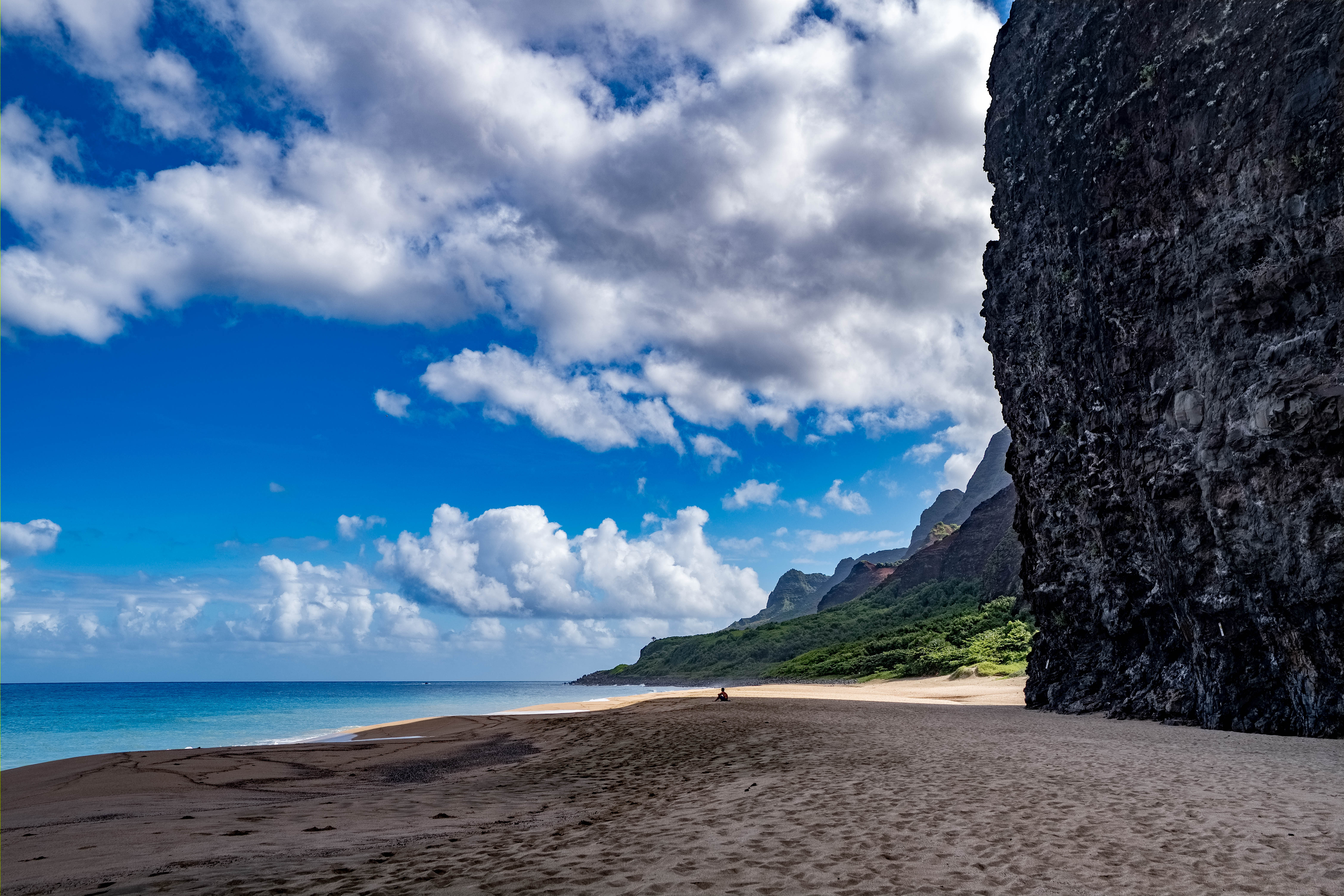
Hawaii, US

Kalalau Beach

Na Pali Coast Kauai Hawaii (32406276598).jpg

Hawaii, US

Kalalau Beach

The beach at the end of one of the world's most dangerous hikes — an 11-mile Nā Pali cliff trail guarding a valley that was a Hawaiian home and a site of anti-colonial resistance, not empty paradise.

Na Pali Coast Kauai Hawaii (32406276598).jpg · <a rel="nofollow" class="external text" href="https://www.flickr.com/people/132646954@N02">dronepicr</a> · CC BY 2.0
Nearest airport
BKH · 21 km
Tier
Featured
I’m here for
Story

Kalalau Beach is the reward and the reckoning at the end of the Nā Pali Coast, on the roadless northwest shore of Kauaʻi. A wide crescent of sand sits at the foot of fluted green cliffs — the pali — that rise more than 2,000 feet almost straight from the sea, folded into knife-edge ridges that no road has ever crossed. There is a waterfall at the far end for fresh water and nothing else: no store, no tap, no lifeguard, no lights.

You earn it or you do not come. The only ways in are the 11-mile Kalalau Trail from Keʻe Beach, or, in the calm of summer, a permitted kayak or boat landing from the sea. The trail is not a stroll. It climbs and drops along cliff edges, fords streams that flash-flood without warning, and passes Hanakāpīʻia Beach two miles in, where the stream and surf have drowned so many people that a sign there tallies the dead. Outside magazine has listed it among the twenty most dangerous hikes in the world, noting that more than a hundred people have died swimming the trail's remote beaches. A permit caps you at five nights.

And here is the part the brochures leave out: Kalalau is not, and never was, empty wilderness. Native Hawaiians farmed this valley for generations, growing kalo — taro — in a vast complex of terraced fields, and lived here in numbers into the twentieth century. What tourism now sells as untouched paradise is in fact an abandoned home, its stone terraces still visible under the invasive trees.

It is also a place of resistance. In 1893, the year the Hawaiian Kingdom was overthrown, a man named Koʻolau who had contracted leprosy fled into Kalalau with his wife Piʻilani and their son rather than be torn from his family and exiled to the settlement on Molokaʻi. He shot and killed a deputy sheriff, outlasted an armed government force sent to take him, and died free in the valley. His wife walked out and told the story; Jack London later turned it into a famous, and badly distorted, short story.

So Kalalau is one of the most beautiful beaches on Earth and one of the most demanding, and underneath the postcard it is a haunted, contested Hawaiian landscape — a home, a farm, and a battlefield, not a blank paradise.

The spike

The beach at the end of one of the world's most dangerous hikes — an 11-mile Nā Pali cliff trail guarding a valley that was a Hawaiian home and a site of anti-colonial resistance, not empty paradise.

The spike at Kalalau is a gauntlet with a false floor: an extraordinary physical trial that most people meet head-on, sitting on top of a history most people never learn they are walking through.

Start with the gauntlet. The Kalalau Trail runs eleven miles along the Nā Pali Coast from Keʻe Beach to Kalalau Beach — twenty-two miles round trip. Two miles in, it reaches Hanakāpīʻia Beach and its stream; this is where casual day-hikers turn around, and where people die. The stream flash-floods, and the shorebreak has drowned swimmers for decades. Beyond Hanakāpīʻia the trail climbs from sea level to 800 feet in a little over a mile, threads three dangerous stream crossings, passes the hanging valley of Hanakoa at mile six, and finishes with the steep red-dirt descent of Red Hill down to the sand. Outside magazine rated it one of the twenty most dangerous hikes on the planet, noting that more than a hundred people have died swimming the trail's remote beaches. The record bears it out: in February 2013 a woman drowned crossing the Hanakāpīʻia stream in a flash flood and 54 hikers were stranded; that April, 121 hikers had to be rescued over two days when heavy rain made the streams impassable; hikers have died from falls at Red Hill and near the Kalalau waterfall. To camp beyond Hanakāpīʻia you need a wilderness permit from the state, and you are capped at five consecutive nights; since catastrophic floods in 2018, even the first two miles require a Hāʻena State Park reservation booked in advance. In the calm of summer there is one alternative to walking: permitted kayakers and boats can land at Kalalau from the sea, when the Nā Pali surf drops enough to make a beach landing survivable. In winter that same shore is a wall of dangerous water and the option closes entirely.

That is the spike everyone sees. The false floor is what the trail is built over. Kalalau Valley — broad, flat-bottomed, nearly a mile across and walled by 2,000-foot cliffs — was not wilderness. It was one of the most productive Native Hawaiian valleys on Kauaʻi, terraced into a vast system of loʻi kalo, irrigated taro fields, and populated well into the twentieth century until the last farming families finally left. The stone terraces are still there under the guava and invasive trees. Calling it 'pristine' erases the people who made it a home.

And it was a place they fought for. In 1893, as the Hawaiian Kingdom was being overthrown, the new Provisional Government intensified the forced exile of people with leprosy — Hansen's disease — to the isolation settlement at Kalaupapa on Molokaʻi, a place Hawaiians called the grave of living death. A Kauaʻi paniolo named Kaluaikoʻolau — Koʻolau — had the disease, and so did his young son Kaleimanu. Told he would be shipped away without his wife, Koʻolau refused and fled with Piʻilani and Kaleimanu deep into Kalalau. When Deputy Sheriff Louis Stolz came to take him, Koʻolau shot and killed him on June 27, 1893. The government sent an armed force of some thirty-five men and even shelled the valley; they captured 27 other sick people who had hidden there, but never took Koʻolau. The family lived off the land for years. The boy died, then Koʻolau died of the disease, and Piʻilani buried them and walked out alone. Her firsthand account was recorded in Hawaiian and published in 1906. Jack London, who visited Hawaiʻi, spun the episode into a short story, 'Koolau the Leper,' collected in 1912 — vivid, widely read, and false enough to the real family that Hawaiian writers have spent a century correcting it.

The reckoning did not end when the farmers left. Kalalau's remoteness has made it a magnet for people who come and never leave: a long-running, illegal off-grid camping scene has taken root in the valley's terraces, well past the five-night limit, and the state periodically sweeps it. Layered on top is straightforward over-tourism — so many people wanted the Instagram version of Nā Pali that after the 2018 floods the reopening came with a hard daily cap on visitors and a mandatory shuttle, an admission that the coast cannot absorb everyone who wants it. The valley that was emptied of its Hawaiian farmers now has to be actively protected from the crowds who come to photograph its emptiness.

Put the two layers together and Kalalau's real spike comes into focus. This is a beach you reach only by surviving one of the world's hardest trails, to arrive at a valley that looks like untouched Eden and is nothing of the kind — a farmed, lived-in, fought-over Hawaiian place whose people were pushed out and whose most famous story is one of a family resisting a colonial government's power to break it apart. The sand is stunning. The honest reason to know Kalalau is everything standing behind it.

Sunset on Kalalau Beach - panoramio.jpg
Culture

Where it shows up

History
  • The True Story of Kaluaikoʻolau · 1906
    Piʻilani (recorded by Kahikina Sheldon)

    Piʻilani's firsthand account of the family's flight into Kalalau and Koʻolau's death — the authoritative Hawaiian record, later translated into English by Frances N. Frazier.

Literature
  • 'Koolau the Leper' (Jack London) · 1912
    Jack London

    London's fictionalized short story about Koʻolau, collected in The House of Pride — famous, widely taught, and 'twisted' enough from the real events that it has drawn a century of correction.

Other
  • 'The 20 Most Dangerous Hikes'
    Outside magazine

    Outside's listing of the Kalalau Trail among the most dangerous hikes in the world, noting that beyond the trail's own hazards, more than a hundred people have died swimming its remote beaches.

Napali Coast - Flickr - romainguy.jpg
History

What happened here

  1. 1893resistance

    The Leper War: Koʻolau's stand

    In the year the Hawaiian Kingdom is overthrown, Koʻolau flees into Kalalau with his wife Piʻilani and son rather than be exiled to Molokaʻi, and kills Deputy Sheriff Louis Stolz on June 27. An armed government force shells the valley but never takes him.

    Wikipedia →
  2. 1906account

    Piʻilani's true story is published

    Piʻilani's firsthand account of the family's flight and Koʻolau's death, recorded by Kahikina Sheldon, is published in Hawaiian — the authoritative record of what happened in the valley.

  3. 1912literature

    Jack London's 'Koolau the Leper'

    Jack London's fictionalized short story about Koʻolau appears in his collection The House of Pride — widely read, and distorted enough that Hawaiian writers have spent a century correcting it.

  4. 1920departure

    The last farmers leave

    By the early twentieth century the last permanent Native Hawaiian residents have left Kalalau, ending generations of taro farming and leaving the terraced fields to the forest.

    Wikipedia →
  5. 2018access

    Catastrophic floods close the north shore

    Record April 2018 rains flood Kauaʻi's north shore and Hāʻena, cutting road access to the trailhead and forcing a long closure and rethink of how many people the coast can absorb.

  6. 2019access

    Reservations and a shuttle arrive

    Hāʻena State Park reopens with a day-use reservation and shuttle system (via GoHaena.com) capping daily visitors, on top of the wilderness camping permit already required beyond Hanakāpīʻia.

The honest part
One of the world's hardest trails ends at a valley sold as untouched paradise — a farmed, lived-in, fought-over Hawaiian home it never actually was.

Two honest things sit under the postcard. The first is danger: the trail to Kalalau is genuinely lethal — narrow cliff edges, flash-flooding streams, and the drownings at Hanakāpīʻia that a warning sign there counts. This is not a beach to underestimate for a photograph. The second is history: Kalalau is sold as pristine wilderness, but it was a populated Native Hawaiian valley of terraced taro farms and the site of the Koʻolau resistance, its people gone not by nature but by disease policy and dispossession. Today the valley also carries a chronic problem of illegal long-term camping, and a reservation system that tries, imperfectly, to cap the crowds loving it to death. Come humbled on both counts, or reconsider coming at all.

Sawtooth (209049249).jpeg
Anatomy

The shape of the place

Red Hill & the trail's end

12%

The steep red-dirt descent where the eleven-mile trail finally drops out of the cliffs onto the sand — the first, staggering view of the beach after a full day of walking.

Best for Arriving; the payoff view down onto Kalalau

The last half-mile is a loose, steep red-dirt slope; hard on tired legs and slick when wet.

The wilderness crescent

50%

The wide sand beach at the foot of the valley, backed by 2,000-foot pali — the campsite, the swimming (in calm summer only), and the whole reason people walk eleven miles.

Best for Camping with a permit, the sense of total remoteness

Winter surf here is powerful and dangerous; there are no lifeguards and no rescue close at hand.

The waterfall & sea caves

88%

At the far western end a waterfall spills off the cliff, the only fresh water at Kalalau, near shaded sea caves in the rock.

Best for Fresh water (treat it), shade, a rinse

A hiker died in a fall near the beach waterfall in 2012; mind loose rock, and treat all water before drinking.

Landmarks

Kalalau Valley

valley

The broad, flat-bottomed valley nearly a mile across behind the beach, terraced by Native Hawaiians into taro fields and walled by fluted cliffs over 2,000 feet high.

Wikipedia →

The Nā Pali pali

cliffs

The knife-edge, fluted green cliffs of the Nā Pali Coast that rise straight from the sea and let no road cross — the defining wall of the whole coast.

Wikipedia →

Hanakāpīʻai Beach & stream

beach and stream

Two miles along the trail, the notorious stream crossing and shorebreak where a warning sign tallies the dead; more than a hundred people have died swimming the trail's remote beaches.

Wikipedia →
A day here

From first light to dark

Dawn

First light climbs the fluted pali while the valley floor stays in shadow. Campers stir on the sand; the beach is coldest and emptiest now, the surf the only sound.

Midday

The sun bakes the exposed crescent and hikers who started at Keʻe before dawn come stumbling down Red Hill onto the sand. The waterfall at the far end is the only fresh water, and it must be treated.

Golden hour

Late light sets the folded green cliffs glowing — the hour every photograph of Nā Pali is chasing — and the whole valley turns amber above a darkening sea.

Night

No lights anywhere. Stars, the surf, and somewhere back in the terraces the fires of long-stay campers living off-grid in a valley that was a home long before it was a trophy.

Kalalau Beach - Alone - Flickr - sergejf.jpg
Sea & surf

What the water does

JFMAMJJASONDmetres (significant wave height)

Solid = typical monthly wave height; pale = the bigger days (90th pct). Offshore/regional swell from Open-Meteo Marine (ERA5 Ocean reanalysis, 2023–2024); a sheltered cove may sit calmer than this.

Heavy — a powerful, surf-driven coast
Typical wave height
2.05 m
Biggest swell
Jan · 3.21 m
Calmest
Jul · 1.36 m
Typical period
10 s (groundswell)
Before you go

Things to know

Permits are required

Camping beyond Hanakāpīʻia needs a Nā Pali Coast State Wilderness Park permit from Hawaiʻi DLNR; the first two miles need a Hāʻena State Park reservation via GoHaena.com. Going without is a misdemeanor.

The trail is genuinely dangerous

Eleven miles of narrow cliff-edge trail rated among the world's twenty most dangerous; deaths from falls and from flash-flooded stream crossings recur, and rescue is far away.

Never swim Hanakāpīʻai

The stream and shorebreak at mile two have drowned many people; a sign there tallies the dead. Strong currents, no lifeguard, sudden flash floods.

Five nights maximum

Camping at Kalalau Beach is capped at five consecutive nights; Hanakoa Valley allows one night on the same permit. There is no food, store, or tap — carry everything.

Getting to Kauaʻi

Most visitors fly into Lihuʻe (LIH), not the west-side Barking Sands airfield the map lists; the trailhead is at Keʻe Beach, Hāʻena, on the north shore.

Winter closes the sea route

Kayak or boat landing is only feasible in calm summer surf; in winter the Nā Pali shore is dangerous and the trail's streams flood.

Surf & rip

Powerful water — strongest around Jan, gentlest in Jul. Mind rip currents; this isn't a wade-in-anywhere beach.

Sharks

No incidents on record in the global shark-attack file.

Plan

If you go

Getting there
Nearest airport
Barking Sands Airport (BKH) · 21 km
Nearest town
Princeville · 19 km

Kalalau Beach can be reached only by the 11-mile Kalalau Trail from Keʻe Beach at Hāʻena, on the north shore of Kauaʻi, or — in calm summer months only — by permitted kayak or boat. There is no road and no services of any kind. A Nā Pali Coast State Wilderness Park camping permit (Hawaiʻi DLNR) is required beyond Hanakāpīʻia, and the trailhead area itself requires a Hāʻena State Park reservation via GoHaena.com. The nearest full airport is Lihuʻe (LIH); the Barking Sands (BKH) airfield the map lists is a west-side military strip, not a practical arrival point.

When to go
  • Summer kayak season · Roughly May to September

    In the calmer summer months the Nā Pali surf drops enough that permitted kayakers and boats can land at Kalalau from the sea — the only alternative to the eleven-mile trail. In winter the same shore is pounded by dangerous surf and the option closes.

What to eat & drink
Everything on your back

There is no food, no store, and no tap water at Kalalau — nothing. Every meal across the five-night permit you carry eleven miles in, and every scrap you can't eat you carry out. The only water is the stream and the waterfall, which must be filtered or treated.

Kalalau Beach (carry-in only)

Feral fruit in the valley

The old Hawaiian valley still grows guava, mango, and other fruit gone wild among the taro terraces, and long-stay campers live partly off it. It supplements but never replaces what you pack — do not plan to forage your way through five days.

Kalalau Valley

Sources & references
  1. Wikipedia: Kalalau Trail · cited 2×
  2. Outside magazine · cited 2×
  3. Wikipedia: Kalalau Beach
  4. Wikipedia: Kalalau Valley
Colophon · Provenance

Where this page comes from

Geography, facilities
OpenStreetMap (ODbL) for geometry and facility tags within 500 m of the beach centroid. GeoNames for city/airport distances.
Climate & ocean
Open-Meteo ERA5 + Marine archive, 2014–2023 monthly normals.
Photography
Archival, original tone (Tier B — Wikimedia Commons). Each image licensed per its own terms; attribution visible inline.
History & culture
Every factual claim is linked to its source in the prose above. Wikipedia citations inline. Non-wiki sources named where relevant.
Editorial voice
Register: severe. Written to pass a local's nod test; corrections welcome.
Written by Erin Rose
Last reviewed 2026-04-19
v0.9in editorial development toward v1.0