Kerala, IN

Kappad

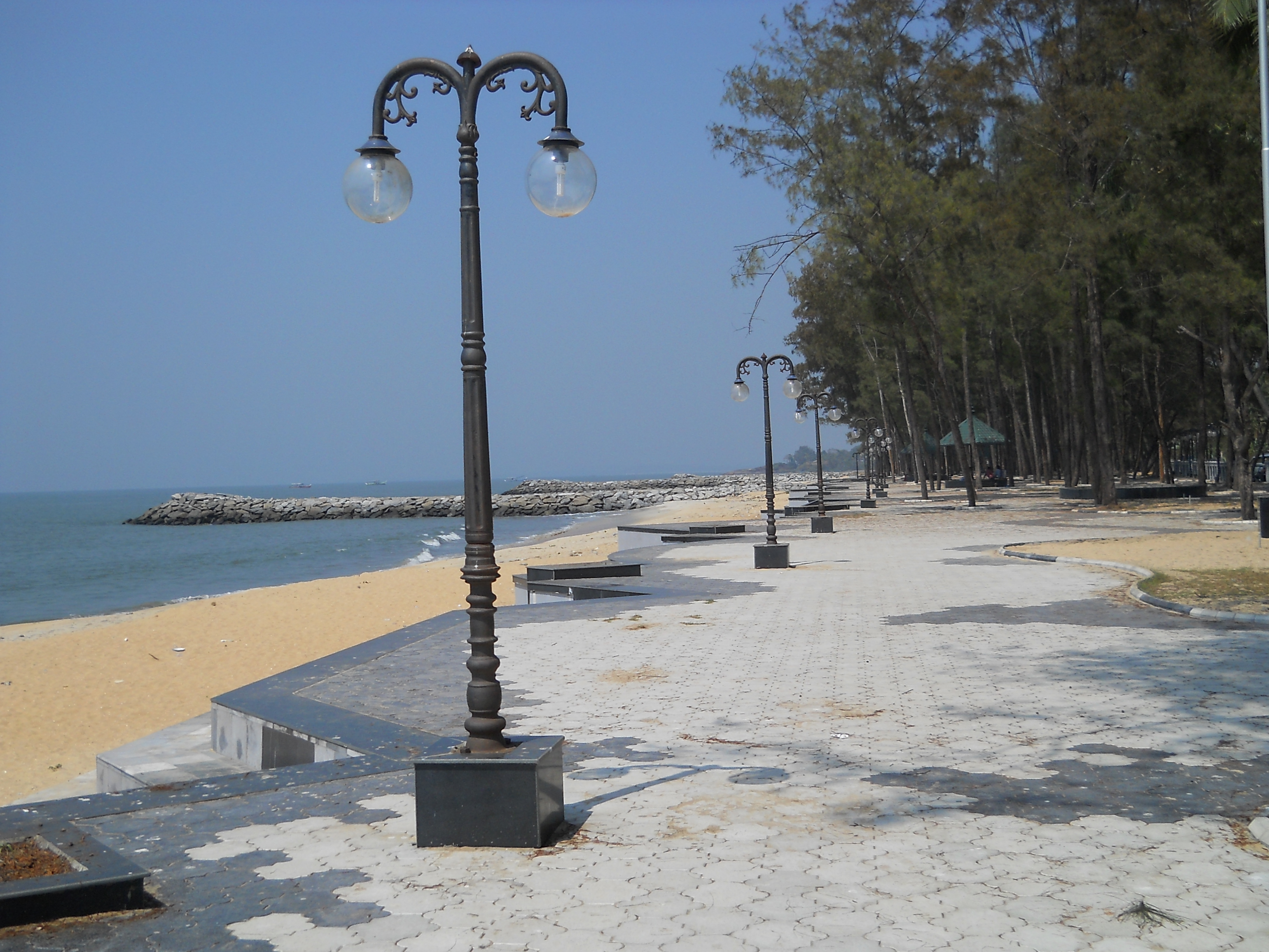
Kappad beach kerala.jpg

Kerala, IN

Kappad Beach

Kappad's stone monument says Vasco da Gama "landed here" in 1498; the voyage's logbook puts his fleet offshore and his first step ashore further south.

Kappad beach kerala.jpg · <a rel="nofollow" class="external text" href="https://www.flickr.com/people/7209155@N03">Dijaraj Nair</a> from Mangalore, INDIA · CC BY-SA 2.0
Nearest airport
CCJ · 38 km
I’m here for
Story

Kappad Beach faces west into the Arabian Sea on the Malabar coast of Kerala, about 16 kilometres north of Kozhikode (Calicut) and 10 kilometres from the railway town of Koyilandy. Its Malayalam name is Kappakadavu. The sand is ordinary quartz and the water is calm for most of the year, with a mean wave height near a third of a metre. A rocky headland, topped by a temple that local accounts date to roughly 800 years, breaks the shoreline, and the Korapuzha backwaters run behind the beach.

A few steps back from the sand stands a low stone pillar. Its plaque reads: "Vasco da Gama landed here, Kappakadavu, in the year 1498." The Kerala Department of Archaeology notified it as a protected monument in 1975, and it is the reason a quiet stretch of coast is on the tourist map at all. Da Gama's arrival is a real hinge of world history — the opening of the sea route from Western Europe to the Indian Ocean — and the pillar plants that moment on this beach.

The voyage's own logbook does not quite agree. The only eyewitness record of the first voyage is the Roteiro, the anonymous fleet journal. It says the ships raised the Malabar coast on 20 May 1498, that the pilot at first mistook Capua — Kappad — for Calicut, and that they anchored about a league and a half offshore. They did not beach. The fleet was then moved south to Pandarani, or Pantalayani Kollam, a safer monsoon anchorage, and it was there, on Monday 28 May 1498, that da Gama went ashore with thirteen men to meet the Zamorin of Calicut.

The gap has been noted for a long time. M. G. S. Narayanan, the historian of medieval Kerala, has argued that the landing was at Panthalayini near Koyilandy, not at Kappad, and that the popular error has never been officially corrected. Even the date is contested: the Roteiro gives 20 May, while Gaspar Correa's later chronicle places the arrival on 26 August 1498. Kappad commemorates, precisely and in stone, an event its primary source locates offshore, days later, and somewhat elsewhere.

The modern beach has kept a cleaner record. Kappad was one of the first eight Indian beaches to earn the international Blue Flag in October 2020, a Danish-run environmental and safety standard judged against 33 criteria, and it has held the certification for six consecutive years as of November 2025. A 2007 state beautification worth about 1.5 crore rupees added a corniche, a park, restrooms and a restaurant. But the pillar with the disputed verb is what most people come to photograph.

The spike

Kappad's stone monument says Vasco da Gama "landed here" in 1498; the voyage's logbook puts his fleet offshore and his first step ashore further south.

Most beaches that claim a place in history claim it loosely. Kappad claims it to the year, to the man, and to the spot, on a stone: "Vasco da Gama landed here, Kappakadavu, in the year 1498." The plaque sits on a low pillar a few steps back from the sand, a protected monument under the Kerala Department of Archaeology, notified in 1975. It is the reason a quiet stretch of Malabar coast about sixteen kilometres north of Kozhikode is on the tourist map at all. It is also, by the account of the voyage's own logbook, not quite true.

What the monument says. The claim is specific and confident: this beach, Kappakadavu, is where the sea route from Europe to India opened. Da Gama's arrival is one of the genuine hinge points of world history — the first time ships sailed from Western Europe to the Indian Ocean, and the start of the Portuguese, and then wider European, presence in Asia. Kappad's pillar plants that moment on this sand. Kerala Tourism repeats it, guidebooks repeat it, and the date usually attached is 20 or 27 May 1498.

What the logbook records. The only eyewitness account of the first voyage is the Roteiro, the anonymous journal kept by a member of the fleet and often attributed to Alvaro Velho. It does not describe a landing at Kappad. It records that on 20 May 1498 the fleet raised the Malabar coast, and that the pilot mistook Capua — Kappad — for Calicut itself before the error was corrected. The ships anchored about a league and a half from shore. They did not beach. On 22 May da Gama sent one of the degredados, the convicts carried for exactly such errands, toward Calicut, where he was taken to two Tunisian Moors who spoke Castilian and Genoese. The fleet was then moved south to Pandarani — Pantalayani Kollam — a safer monsoon anchorage. And it was there, not at Kappad, that Vasco da Gama himself first set foot on Indian soil: on Monday 28 May 1498, going ashore with thirteen men to be carried inland to the Zamorin of Calicut.

The gap between the two. So the monument compresses a week of careful, wary manoeuvring into a single clean verb, landed, and pins it to the one spot the fleet mistook and sailed away from. Da Gama's ships were off Kappad; the man went ashore some distance south. Historians have said so for a long time. M. G. S. Narayanan, the historian of medieval Kerala, has argued flatly that the landing was at Panthalayini near Koyilandy, not at Kappad, and that the popular error has never been officially corrected. Even the date is unsettled: the Roteiro gives 20 May, but Gaspar Correa's later chronicle places the arrival on 26 August 1498, a date some scholars prefer because it fits the monsoon sailing window better than May does.

Why the wrong version won. The reason Kappad holds the memory is not documentary; it is geographic and administrative. Kappad is an accessible, named beach with a road, a headland, and, since the 1970s, a state monument. Pantalayani Kollam is a working stretch of coast without the same tourist frame. Once the Archaeology Department set a dated stone on Kappad in 1975, the claim hardened into fact by repetition. The plaque became the citation, and the citation became the beach's identity.

Why this is the spike. This is what makes Kappad worth a page, and it is not the sand, which is unremarkable quartz beach with calm water and a mean wave height around a third of a metre. It is that the beach is a monument to a contested claim — a place that commemorates, precisely and in stone, an event the primary source locates offshore, days later, and somewhat elsewhere. It is a rare and honest kind of tourist site: one where the sign and the source disagree, and where the disagreement is itself the history. The Portuguese did come, the sea route did open, and the world did change. It simply may not have started on the sand where the pillar says it did.

What is here now. The modern beach has kept a cleaner record than its monument. Kappad was one of the first eight Indian beaches to receive the international Blue Flag, in October 2020, and it has retained the Danish-run certification — judged against 33 environmental and safety criteria — for six consecutive years as of November 2025. A 2007 state beautification worth about 1.5 crore rupees, launched by then tourism minister Kodiyeri Balakrishnan, added a corniche, a park, restrooms and a restaurant. A rocky headland topped by an old temple breaks the shoreline, and the Korapuzha backwaters run behind it, giving the beach a second, quieter approach by boat. But the grey stone with the confident verb is the thing people come to photograph, and the argument underneath it is the reason to stay a while.

Kappad.jpg
Culture

Where it shows up

Literature
  • Roteiro da primeira viagem de Vasco da Gama · 1838
    Anonymous (attributed to Alvaro Velho)

    The only eyewitness journal of the 1497–99 voyage, first published in 1838 and translated by E. G. Ravenstein in 1898. It records the fleet anchoring offshore near Kappad and da Gama landing later at Pantalayani, contradicting the beach's plaque.

  • Os Lusiadas · 1572
    Luis de Camoes

    Portugal's national epic, built around Vasco da Gama's sea voyage to India, which fixed the arrival as a founding event of European expansion.

History
  • Vasco da Gama

    The Portuguese explorer (c. 1460s–1524) whose 1498 arrival on the Malabar coast opened the sea route between Europe and India. Kappad's monument commemorates that arrival.

  • M. G. S. Narayanan

    The historian of medieval Kerala who has publicly argued that da Gama's landing was at Panthalayini near Koyilandy, not at Kappad, and that the misattribution has never been officially corrected.

Kappad beach 2.jpg
History

What happened here

  1. 1498other

    Da Gama's fleet reaches the Malabar coast

    On 20 May 1498 the first Portuguese fleet raises the coast near Kappad. The pilot at first mistakes Capua (Kappad) for Calicut, and the ships anchor about a league and a half offshore rather than beaching.

    Wikipedia →
  2. 1498other

    Da Gama goes ashore at Pantalayani Kollam

    The fleet is moved south to the safer Pandarani (Pantalayani Kollam) anchorage. On Monday 28 May 1498 da Gama lands with thirteen men and is taken inland to meet the Zamorin of Calicut — his first landfall, some distance from Kappad.

    Wikipedia →
  3. 1572cultural

    Camoes publishes Os Lusiadas

    The Portuguese poet Luis de Camoes publishes the epic Os Lusiadas, which makes Vasco da Gama's sea voyage to India its central subject and fixes the arrival in European cultural memory.

    Wikipedia →
  4. 1898cultural

    Ravenstein's English Roteiro is published

    E. G. Ravenstein's English edition of the anonymous voyage journal, A Journal of the First Voyage of Vasco da Gama, is published by the Hakluyt Society, making the eyewitness account that contradicts the Kappad plaque widely available.

  5. 1975policy

    Kappad monument notified

    The Kerala Department of Archaeology notifies the stone pillar at Kappad — inscribed "Vasco da Gama landed here, Kappakadavu, in the year 1498" — as a protected monument, formalising the beach's landing claim.

  6. 2007policy

    Beach beautification launched

    Kerala tourism minister Kodiyeri Balakrishnan launches a beautification programme worth about 1.5 crore rupees at Kappad, adding a corniche, a park, restrooms and a restaurant.

    Wikipedia →
  7. 2020policy

    Kappad earns the Blue Flag

    Kappad is named one of India's first eight Blue Flag beaches, certified by the Foundation for Environmental Education against 33 environmental, safety and access criteria.

  8. 2025other

    Sixth consecutive Blue Flag renewal

    Kappad retains its Blue Flag certification for a sixth straight year, with an on-site orchid rehabilitation project cited among the compliance highlights.

The honest part
“The stone names the year, the man, and the spot; the voyage's own logbook puts the ships offshore and the man ashore days later, further south.”

The uncomfortable part of Kappad is the monument itself. The stone says Vasco da Gama "landed here" at Kappakadavu in 1498, and the state has left that claim standing since it notified the monument in 1975. The fleet's own logbook, the Roteiro, does not support it: the ships anchored about a league and a half offshore after mistaking Kappad for Calicut, and da Gama went ashore days later and further south, at Pantalayani Kollam. Historian M. G. S. Narayanan has said plainly that the landing was near Koyilandy, not here, and that the error has never been corrected. Kappad's identity as the beach where Europe reached India rests on a plaque that its primary source contradicts.

The state does not conceal any of this, and none of it makes the beach a fraud. The Portuguese fleet was demonstrably off this coast in 1498, and the voyage it belonged to did change world history. What is worth saying honestly is that a dated monument is not the same as a settled fact. Kappad is a clean example of how a convenient, accessible spot can absorb an event that happened, more precisely, nearby.

Kappad 2.jpg
Anatomy

The shape of the place

The rocky headland and temple

20%

A rocky outcrop that pushes into the sea at one end of the beach, topped by a temple that local accounts date to roughly 800 years. The rocks make this end scenic but hazardous to swim near.

Best for Views and photography at sunset

Slippery rocks and stronger water movement; keep clear of the outcrop when swimming.

The Vasco da Gama monument

50%

The low grey stone pillar set back from the sand, inscribed with the 1498 landing claim and notified as a protected monument in 1975. It is the beach's focal point and the reason most visitors come.

Best for Reading the plaque against the primary-source dispute

The claim is contested by the voyage's own logbook and by historians; treat the stone as a monument, not a settled fact.

The main sand and corniche

60%

The open sweep of quartz sand fronted by the 2007 corniche and park, with the beach restaurant and restrooms behind it. Calm water for most of the year makes this the main wading and sitting stretch.

Best for Walking, sitting, and the west-facing sunset

Shade is scarce; the June–August monsoon brings rain and rougher surf.

The Korapuzha backwater side

85%

Behind the beach, the Korapuzha backwaters meet the coast, giving Kappad a quieter inland approach by boat as an alternative to the road.

Best for A backwater boat approach and calmer water

Boat services are informal and seasonal; arrange locally.

Landmarks

Vasco da Gama monument

monument

A low stone pillar a few steps back from the sand, inscribed "Vasco da Gama landed here, Kappakadavu, in the year 1498," notified as a protected monument by the Kerala Department of Archaeology in 1975. It anchors the beach's identity despite the contested landing claim.

Wikipedia →

Headland temple

temple

A small temple on the rocky outcrop at one end of the beach, dated in local accounts to roughly 800 years, well before the 1498 arrival the beach is known for.

Kappad corniche and park · 2007

promenade

The seafront walkway, park, restrooms and restaurant built under the 2007 state beautification programme worth about 1.5 crore rupees.

A day here

From first light to dark

Dawn

Because the beach faces west, first light comes over the land behind it rather than off the water, and the sea stays grey and flat in the early calm. Fishing craft work offshore, and the monument pillar sits unlit and largely unnoticed before the day's visitors arrive.

Midday

The sun is high over the Arabian Sea and shade is scarce on the open quartz sand; the water is warm and, outside the monsoon, gentle enough to wade. Midday is when tour groups reach the pillar, read the plaque, and photograph it against the rocky headland.

Golden hour

The set piece is the evening. Kappad faces the open sea, so the sun drops straight into the water off the west-facing sand, and the headland and its temple stand dark against the last light. This is the busiest and best hour on the beach.

Night

After sunset the sand empties quickly; there is no lit promenade nightlife, only the corniche, the closed restaurant, and the sound of the surf. The Korapuzha backwaters behind the beach go dark, and the monument is left to itself until morning.

Kappad 3.jpg
Sea & surf

What the water does

JFMAMJJASONDmetres (significant wave height)

Solid = typical monthly wave height; pale = the bigger days (90th pct). Offshore/regional swell from Open-Meteo Marine (ERA5 Ocean reanalysis, 2023–2024); a sheltered cove may sit calmer than this.

Calm — gentle swimming water most of the year
Typical wave height
0.34 m
Biggest swell
Jul · 0.59 m
Calmest
Nov · 0.16 m
Typical period
8.2 s (groundswell)
Before you go

Things to know

The landing claim is disputed

The monument says da Gama landed here in 1498, but the voyage's own logbook and historians place the fleet offshore and the landing further south at Pantalayani Kollam. Read the plaque as a monument, not a verified fact.

Water is calm, but not always

The annual mean wave height is about 0.34 m and the sea is usually gentle, but the June–August monsoon brings heavy rain and rougher surf, and the rocks off the headland are hazardous. Do not assume a lifeguard is on duty outside busy periods.

Getting there

Koyilandy is the nearest railway station (~10 km) and Kozhikode (Calicut) city is about 16 km south; Calicut International Airport (CCJ, at Karipur) is roughly 38 km by road. A boat down the Korapuzha backwaters is an alternative approach.

Facilities are modest

The 2007 beautification added a corniche, park, restrooms and a beach restaurant, and the beach is Blue Flag certified, but there is no large commercial strip; buy food and stay in Kozhikode.

Swimming

Usually calm water — among the gentler beaches for a swim.

Sharks

No incidents on record in the global shark-attack file.

Plan

If you go

Getting there
Nearest airport
Calicut International Airport (CCJ) · 38 km
Nearest town
Naduvannur · 13 km

Kappad is on the coast about 16 km north of Kozhikode (Calicut), Kerala. The nearest railway station is Koyilandy (Quilandy), roughly 10 km away, and Kozhikode's main station is about 16 km; Calicut International Airport (CCJ, at Karipur) is roughly 38 km by road. From Kozhikode, drive north via NH 66 and turn coastward near Thiruvangoor; local buses and taxis serve the beach. A boat run down the Korapuzha backwaters offers a slower inland approach.

What to eat & drink
Kozhikodan (Malabar) biryani

The signature rice dish of the Malabar coast, made with short-grain khyma/jeerakasala rice and mutton or chicken and distinct from Hyderabadi styles. It is a Kozhikode restaurant staple, not sold on the beach itself.

Restaurants in Kozhikode (Calicut), about 16 km south

Kozhikodan halwa

A dense, glossy sweet cooked from wheat, coconut oil, sugar and ghee, so identified with the city that the halwa lane of the old bazaar is nicknamed Mittai Theruvu (Sweetmeat Street).

SM Street / Mittai Theruvu, Kozhikode

Malabar fish and mussels

The coastal catch, including kallummakkaya (mussels) often stuffed and fried, and fish grilled in banana leaf with Malabar spice. Best found in Kozhikode's seafood restaurants rather than at Kappad.

Kozhikode seafood restaurants and coastal toddy shops

Sulaimani and banana chips

Sulaimani, a spiced black tea with lime, and thin coconut-oil banana chips are the everyday Malabar snack; Kappad itself has only the state-built beach restaurant and a few small vendors.

The beach restaurant at Kappad and tea shops in nearby Koyilandy

Sources & references
  1. Kerala Department of Archaeology · cited 3×
  2. Wikipedia: Kappad · cited 2×
  3. Roteiro; Wikipedia: Vasco da Gama
  4. Roteiro (Ravenstein 1898)
  5. Wikipedia: Os Lusiadas
  6. Hakluyt Society; Roteiro
  7. Foundation for Environmental Education
  8. Onmanorama (14 Nov 2025)
  9. Roteiro (Journal of the First Voyage), Ravenstein 1898
  10. M. G. S. Narayanan; Wikipedia: Kappad
  11. Foundation for Environmental Education; Onmanorama
  12. Kerala Tourism; Wikipedia: Kappad
  13. Open-Meteo Marine (ERA5 Ocean reanalysis)
Colophon · Provenance

Where this page comes from

Geography, facilities
OpenStreetMap (ODbL) for geometry and facility tags within 500 m of the beach centroid. GeoNames for city/airport distances.
Climate & ocean
Open-Meteo ERA5 + Marine archive, 2014–2023 monthly normals.
Photography
Archival, original tone (Tier B — Wikimedia Commons). Each image licensed per its own terms; attribution visible inline.
History & culture
Every factual claim is linked to its source in the prose above. Wikipedia citations inline. Non-wiki sources named where relevant.
Editorial voice
Register: wry. Written to pass a local's nod test; corrections welcome.
Written by Erin Rose
Last reviewed 2026-04-19
v0.9 — in editorial development toward v1.0