Hawaii, US

Lanikai Beach

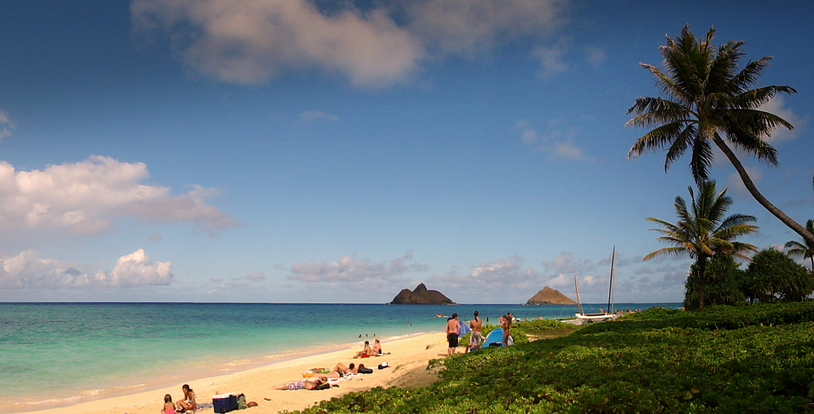
Lanikai Strand auf Oahu.jpg

Hawaii, US

Lanikai Beach

Dr. Beach named it America's best in 1996, then warned its seawalls would erase it; the western end already has.

Lanikai Strand auf Oahu.jpg · <a href="//commons.wikimedia.org/w/index.php?title=User:Hakilon&amp;action=edit&amp;redlink=1" class="new" title="User:Hakilon (page does not exist)">Hakilon</a> · CC BY 3.0
Length
2.9 km
Substrate
sand
Spring tide
0.48 m
Nearest airport
NGF · 9 km
Tier
Featured
I’m here for
Story

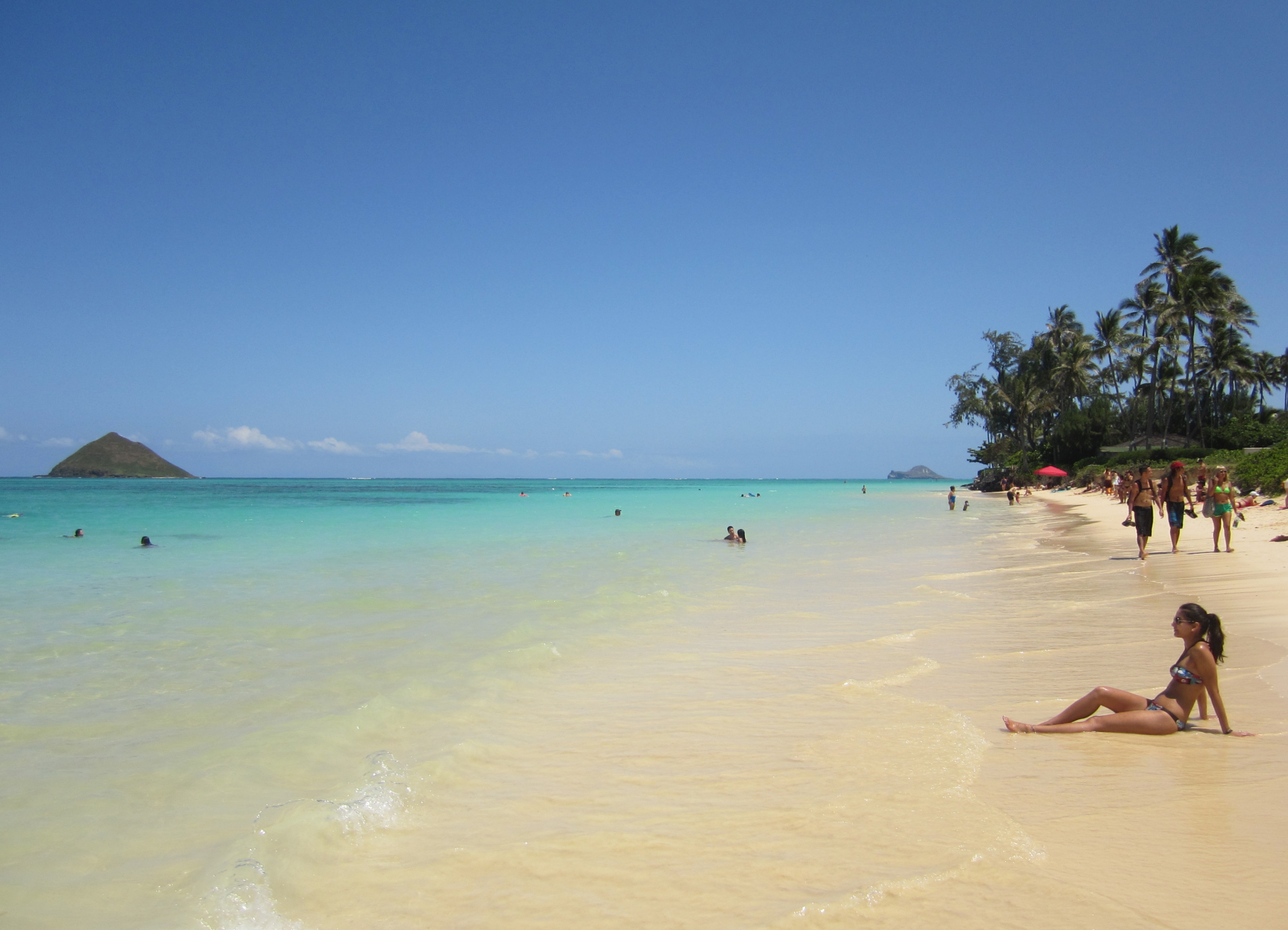
Lanikai Beach runs roughly half a mile along the windward coast of Oahu, just south of Kailua. The sand is fine and pale, the water inside the reef stays unusually flat, and a mile offshore sit two small islands, Moku Nui and Moku Iki, the pair Hawaiians call Na Mokulua and locals call "the Mokes." That view, calm water in the foreground and twin green islets on the horizon, is the reason the beach exists in the public imagination at all.

The name is younger than it sounds. "Lanikai" was coined in 1924 by Charles Frazier, a developer who owned about 300 acres here and was laying out a subdivision. He stacked the Hawaiian words lani (sky, heaven) and kai (sea) to mean "heavenly sea." The grammar is backwards: Hawaiian puts the qualifier after the noun, so "heavenly sea" would actually be Kailani. The place already had a name. Hawaiians knew this stretch as Ka'ohao, and that name predates the lots, the seawalls, and the Instagram geotag by centuries.

There is no Lanikai Beach Park. The shoreline is fronted entirely by private homes, and the public reaches the sand through eleven narrow right-of-way paths squeezed between houses off Mokulua Drive and Aalapapa Drive. There is no public parking lot, no restroom, no lifeguard, no concession. The neighborhood is a single one-way loop with one road in and one road out, and on a busy day as many as 300 cars try to cram into it.

Inside the reef the swimming is genuinely gentle, which is rare for a windward beach and is most of the draw. Beyond the reef the open Pacific behaves like open Pacific. Kayakers cross to Moku Nui, the larger northern islet, where landing is permitted below the high-water line; Moku Iki, the smaller southern one, is closed to landing entirely. Both are part of the Mokulua Islets Seabird Sanctuary, nesting ground for the wedge-tailed shearwater, the bird Hawaiians call 'ua'u kani.

What the postcard leaves out is that the beach is shrinking. Seawalls built to defend the houses have starved the sand, and the western end of Lanikai has already eroded down to rock and wall in places. The man who once crowned it the best beach in America is the same man who predicted this would happen.

The spike

Dr. Beach named it America's best in 1996, then warned its seawalls would erase it; the western end already has.

The singular thing about Lanikai is not the islands or the flat water. It is that the beach is documented, on a national stage, in the act of disappearing, and that the same expert who made it famous is the one who called the disappearance.

In 1996, coastal geologist Stephen Leatherman, who publishes an annual ranking under the name "Dr. Beach," named Lanikai the number-one beach in the United States. The list, released every Memorial Day weekend since 1991, scores beaches on dozens of criteria, and a top placement reliably converts into a flood of visitors. Lanikai got the flood. But Leatherman attached a warning to the crown that almost no other winning beach receives: he cautioned that Lanikai could fall victim to erosion driven by the seawalls protecting the private homes along it. Reporting from the period records that the western end of Lanikai had already eroded away, with a seawall emplaced to hold the line in front of the houses.

Why a wall destroys the beach it protects. A sandy beach is not a fixed object; it is a moving budget of sediment. Waves take sand offshore in storms and rebuild the beach in calmer months, and the beach migrates landward over time as sea level rises. A seawall freezes the back edge of that system in place. When waves hit a wall instead of running up a sloping beach, the energy reflects downward and scours the sand directly in front of the wall, then carries it away. The beach in front of a Hawaii seawall ends up 50 to 75 percent narrower than an unwalled beach nearby, and on a rising shoreline the sand eventually has nowhere left to go. It drowns against the concrete. This is not a Lanikai theory; it is the measured behavior of armored coasts.

The domino effect. A 2018 study in the journal Climatic Change, led by Alisha Summers with Chip Fletcher and colleagues at the University of Hawai'i, mapped Oahu's shoreline across 87 years, from 1928 to 2015. In 1928 the island had essentially no seawalls. By 2015 it had nearly five kilometers of hardened shoreline. Over that span, the net shoreline change flipped from building sand to losing it across 74 percent of the coast, more than 45 percent of that flip caused by "flanking," erosion triggered when a neighbor's seawall redirects wave energy sideways. The result island-wide: nearly 20 percent of beach length already gone, and 55 percent of remaining beaches narrowed. The mechanism the study names explicitly is a hardening domino: the first wall accelerates erosion on the stable beaches beside it, which pushes those owners to build their own walls, which erodes the next stretch. A street of single-family homeowners, each making a rational decision to protect one house, collectively dismantles the beach they all share. Lanikai is a textbook case of exactly that street.

Why this beach and not another. Oahu has many eroding beaches, but Lanikai concentrates the forces that make armoring inevitable. The lots are private all the way to the sand, so there is no public park buffer and no setback room to let the beach retreat. The homes are expensive, which means owners can and will pay for walls. The fame brings volume, which raises the value of the land, which raises the stakes of losing it. And the windward exposure means the open-ocean swell beyond the reef is real, annual mean wave heights around 1.7 meters with winter days pushing past 2.9, so the wall takes a genuine beating. Each of those is a pressure toward hardening, and hardening is the thing that kills the sand.

The honest version of the postcard. People still photograph Lanikai because the central stretch, fronting the reef, still holds sand and still frames the Mokes perfectly. That image is true. It is also partial. Walk west and the beach pinches out against rock and wall. The flat turquoise water is real; so is the riprap. The 1996 crown is real; so is the warning that came stapled to it. The most accurate sentence about Lanikai is that it is simultaneously one of the most photographed beaches in America and one of the better-documented examples of how a famous beach is lost, one rational homeowner at a time, to the walls built in its defense.

'At Lanikai' by D. Howard Hitchcock, 1938.jpg
Culture

Where it shows up

History
  • Dr. Beach #1 ranking (1996) · 1996
    Stephen Leatherman

    Lanikai's selection as America's best beach made it a national name and a tourism magnet.

  • Ka'ohao

    The Hawaiian name for this area that predates the 1924 "Lanikai" branding.

Other
  • "The Mokes"

    Local shorthand for Na Mokulua, the twin islets that define the view and the kayak destination.

Lanikai beach culture.JPG
History

What happened here

  1. 1924naming

    Charles Frazier coins "Lanikai"

    Developer Charles Frazier, owner of about 300 acres of the area Hawaiians called Ka'ohao, names his new subdivision Lanikai, intending "heavenly sea."

    Wikipedia →
  2. 1991ranking

    Dr. Beach launches annual U.S. list

    Coastal geologist Stephen Leatherman begins releasing his annual ranking of America's top beaches each Memorial Day weekend.

    Wikipedia →
  3. 1996ranking

    Lanikai named #1 beach in the USA

    Leatherman ranks Lanikai the best beach in the United States, and visitor traffic to the residential neighborhood surges.

  4. 1997warning

    Erosion warning attached to the crown

    Leatherman warns that Lanikai, then the nation's top-rated beach, may fall victim to erosion from the seawalls built to protect private homes; the western end has already eroded behind a wall.

  5. 2018study

    UH study maps 87 years of Oahu beach loss

    Summers, Fletcher and colleagues publish in Climatic Change: from 1928 to 2015 Oahu went from no seawalls to nearly 5 km of them, losing nearly 20% of beach length and narrowing 55% of beaches via a hardening "domino effect."

  6. 2022conflict

    Residents place rocks to block parking

    Frustrated by visitor gridlock, Lanikai residents line Mokulua Drive with large rocks to keep beachgoers from parking near their driveways.

  7. 2025policy

    City presents Lanikai transportation plan

    Honolulu presents a Lanikai Transportation Management Plan to the Kailua Neighborhood Board proposing to ban parking across much of the one-way loop, where up to 300 cars jam at peak.

The honest part
The walls that save the houses are eating the beach, and the only road in jams with 300 cars trying to see what's left.

Lanikai is a residential neighborhood that the internet turned into an attraction, and the strain shows on the ground. There is no public parking, no restroom, and no lifeguard; access is through eleven narrow paths between private homes, and the only road in is a one-way loop that jams with as many as 300 cars on a peak day. Residents have lined Mokulua Drive with large rocks to keep visitors from blocking their driveways, and in June 2025 the city presented a transportation plan that includes banning parking in much of the loop, a measure that would protect the neighborhood and largely lock out the visitors who made the beach famous. Underneath the parking fight is the slower loss: the seawalls defending those same homes have already erased the western end of the beach, and the physics guarantee more of it goes the same way.

The two problems are the same problem wearing different clothes. Private ownership running to the waterline is what produces both the access squeeze and the wall-driven erosion. There is no neat resolution on offer here, and the honest thing is to say so rather than sell a frictionless beach day.

Lanikai Strand.jpg
Anatomy

The shape of the place

West end

10%

Pinched and armored; sand gives way to rock and seawall fronting private homes.

This is the section that has visibly eroded; thin to no beach at higher water.

Central reef frontage

50%

The widest surviving sand and the classic Mokulua view; this is the stretch in nearly every photograph.

Best for swimming and the postcard view

Calmest water sits inside the reef here.

Toward Wailea Point

88%

The southern run toward the point, quieter than the central frontage.

Best for a less crowded walk

Still fronted by private lots and access paths.

Landmarks

Na Mokulua (Moku Nui and Moku Iki)

islands / wildlife sanctuary

Twin offshore islets a mile out, jointly the Mokulua Islets Seabird Sanctuary. Moku Nui (north, larger) allows landing below the high-water line; Moku Iki (south, smaller) is closed to landing. Both nest wedge-tailed shearwaters.

Wikipedia →

The reef

natural fringing reef

The fringing reef offshore is what flattens the swell and gives Lanikai its unusually calm windward-side water.

Lanikai public access paths

public right-of-way

Eleven narrow walkways between private homes off Mokulua and Aalapapa Drives, the only legal public route to the sand.

A day here

From first light to dark

Dawn

First light comes up behind the Mokes, which is why the eastward view is the one everyone shoots; with a mixed tide the spring range here is only about half a meter, so the waterline barely moves and the reef flat sits glassy. Early is also the only window with open street parking before the loop fills.

Midday

Sun is overhead and the reef-protected water reads bright turquoise; this is when the kayak traffic to Moku Nui peaks and when the access paths between houses are busiest. Bring water and shade, because nothing on the beach sells either.

Golden hour

Late afternoon light goes warm across the sand while the islands fall into silhouette. The crowd thins as day-trippers leave to beat the one-way-loop exit jam.

Night

The sanctuary islets are closed sunset to sunrise, and with no lights or lifeguard the beach goes dark and quiet; wedge-tailed shearwaters return to their burrows on the Mokes after dusk during nesting season.

Compare

How it ranks

Peak warmth
Warmer than 72% of beaches in its country
Peak-month high ≈ 30°C
Beach season
Longer beach season than 93% of beaches in its country
11 comfortable months a year

Ranked against every beach in our database — 228,000+ worldwide.

The Moks from Lanikai.JPG
Sea & surf

What the water does

JFMAMJJASONDmetres (significant wave height)

Solid = typical monthly wave height; pale = the bigger days (90th pct). Offshore/regional swell from Open-Meteo Marine (ERA5 Ocean reanalysis, 2023–2024); a sheltered cove may sit calmer than this.

Exposed — real surf, and rip current to respect
Typical wave height
1.73 m
Biggest swell
Feb · 2.25 m
Calmest
Oct · 1.45 m
Typical period
8.7 s (groundswell)
Before you go

Things to know

No facilities

No restroom, no lifeguard, no concession, no parking lot. Bring water, shade, and a plan to use a bathroom in Kailua.

Parking is the real obstacle

There is no public lot; street parking is limited, enforced, and tow-able, and the city is moving to ban parking across much of the one-way loop. Arrive early or come by bike from Kailua.

Respect the access paths

The only legal way to the sand is the eleven marked right-of-way paths between private homes. Don't cut across yards.

The Mokes have rules

Kayaking is allowed; land only on Moku Nui and only below the high-water line. Moku Iki is closed. Both islets are closed sunset to sunrise as a seabird sanctuary.

Surf & rip

Powerful water — strongest around Feb, gentlest in Oct. Mind rip currents; this isn't a wade-in-anywhere beach.

Sharks

No incidents on record in the global shark-attack file.

Lifeguard

No lifeguard service — swim within your limits.

Plan

If you go

Getting there
Nearest airport
Kaneohe Bay MCAS (Marion E. Carl Field) Airport (NGF) · 9 km
Nearest town
Kailua · 3 km

Lanikai sits about 3 km south of Kailua town on Oahu's windward coast, roughly a 30-40 minute drive from Honolulu over the Pali or Likelike. There is no public parking lot and no beach park; reach the sand only via the eleven marked public right-of-way paths between homes off Mokulua Drive and Aalapapa Drive. Street parking is scarce, actively enforced, and the subject of a proposed loop-wide ban, so the practical approach is to park in Kailua and walk or bike in, or arrive at dawn.

When to go
  • Wedge-tailed shearwater nesting season · roughly spring through fall

    Wedge-tailed shearwaters ('ua'u kani) nest in burrows on the Mokulua islets and return after dusk; the islets are closed sunset to sunrise to protect them.

What to eat & drink
Nothing on the beach itself

Lanikai has no concession, kiosk, or vendor of any kind. Buy food and water before you arrive; the nearest options are back in Kailua town, roughly 3 km away.

On the sand at Lanikai

Kailua-town plate lunch and poke

The town behind the beach is where windward Oahu actually eats, from poke counters to plate-lunch spots. It is the realistic lunch stop for a Lanikai day.

Kailua, ~3 km northwest

Shave ice

Hawaiian shave ice, finely shaved and syruped, is the standard windward-side hot-day treat and is sold around Kailua rather than at the beach.

Kailua town

Sources & references
  1. Summers, Fletcher et al., Climatic Change (2018) · cited 3×
  2. Wikipedia / Images of Old Hawai'i · cited 2×
  3. Honolulu Star-Bulletin / Dr. Beach · cited 2×
  4. Wikipedia
  5. Honolulu Star-Bulletin (1997)
  6. Honolulu Civil Beat (2022)
  7. Honolulu Civil Beat (2025)
  8. World Beach Tour dataset
  9. Images of Old Hawai'i
  10. Honolulu Civil Beat
  11. Open-Meteo Marine (ERA5, 2023–2024)
Colophon · Provenance

Where this page comes from

Geography, facilities
OpenStreetMap (ODbL) for geometry and facility tags within 500 m of the beach centroid. GeoNames for city/airport distances.
Climate & ocean
worldclim_v2.1_2.5m
Tides
eot20
Photography
Archival, original tone (Tier B — Wikimedia Commons). Each image licensed per its own terms; attribution visible inline.
History & culture
Every factual claim is linked to its source in the prose above. Wikipedia citations inline. Non-wiki sources named where relevant.
Editorial voice
Register: romantic. Written to pass a local's nod test; corrections welcome.
Written by Erin Rose
Last reviewed 2026-04-19
v0.9in editorial development toward v1.0