Ionian Islands, GR

Μύρτος

Myrtos2.JPG

Ionian Islands, GR

Myrtos Beach

The white marble that makes Myrtos glow turquoise also makes its water deepen to drowning depth a few steps from shore.

Myrtos2.JPG · Rob Bendall (<a href="//commons.wikimedia.org/wiki/User:Highfields" title="User:Highfields">Highfields</a>) · Attribution
Substrate
pebble
Spring tide
0.15 m
Nearest airport
EFL · 25 km
Tier
Featured
I’m here for
Story

Myrtos Beach lies in the Pylaros region of northwestern Kefalonia, between two mountains: Agia Dynati, at 1,131 meters the island's second-highest peak after Mount Ainos, and Kalon Oros, which rises to 901 meters. Between them a single arc of pebbles cuts a notch in the coast. Wikipedia calls it a mile-and-a-half-long arc; island guides report the swimmable strand as 700 to 800 meters, and the figures do not reconcile. What is not in dispute is the color: the water grades from a pale, almost milky aqua at the waterline to a deep Ionian blue offshore.

The color is the marble. The pebbles here are round, white cobblestones of marble — metamorphosed limestone — and as the sediment grinds finer toward the shoreline it loads the shallows with white particles that scatter light. Wave action drags those sediment plumes along the curve of the bay, and the suspended marble dust is what turns the near water that luminous turquoise. It is not a coral lagoon and not glacial flour. It is rock, broken small, doing optics.

Reaching the sand means committing to the road. A steep, roughly two-kilometer track of hairpin turns drops from the clifftop village of Divarata to beach level. Partway down, a railed viewpoint gives the photograph the beach is known for: the whole white arc from above, the cliffs falling away, the banded blue. In summer a public bus runs from Agia Efimia. Most visitors stop at the viewpoint first, then drive the switchbacks, and the descent is the part of the day people remember as much as the swim.

The reputation is real and old. Myrtos has been voted the best beach in Greece roughly twelve times, and it recurs on best-beach lists for Greece and Europe. In 2001 it played itself on film — the WWI sea mine that washes ashore and detonates in Captain Corelli's Mandolin was staged here, on this arc of pebbles.

The same geology that makes Myrtos photograph like nowhere else makes it dangerous to swim. The marble shelf drops away fast; the water is deep close in, and strong currents and undertow run beneath a surface that often looks calm. People drown here. Local reports describe several deaths in a typical year, and the dead are frequently confident swimmers who trusted unassuming water and went out too far. There is no consistent lifeguard. When the flag is red, the rule is simple, and ignored often enough to be fatal: do not go in.

The spike

The white marble that makes Myrtos glow turquoise also makes its water deepen to drowning depth a few steps from shore.

Myrtos earns its fame and its body count from the same source: it is a beach built almost entirely out of white marble, and marble behaves differently from sand. Understand the rock and you understand both why every photograph of this place looks unreal and why experienced swimmers drown a few steps from where they stood.

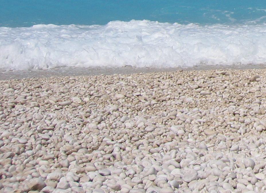
The beach is metamorphosed limestone, ground to cobbles. The pebbles at Myrtos are round, white cobblestones of marble — limestone that heat and pressure recrystallized into a denser, brighter stone. The beach grades by size: coarse cobbles up the back of the strand, finer pebbles toward the water, and below the waterline a load of marble sediment fine enough to stay suspended. That gradient is not cosmetic. It is the whole optical engine of the place. Sunlight entering the shallows hits a dense field of pale, suspended marble particles and scatters back out before it can be absorbed by depth, so the near water reads as a luminous, almost milky aqua. Wave action sweeps these sediment plumes along the curve of the bay, which is why the turquoise band follows the shoreline rather than sitting in a flat sheet. Offshore, past the suspended sediment and over deeper water, the same sea returns to the hard, dark Ionian blue. The two-tone water that makes Myrtos instantly recognizable is a single body of sea reading two different ways because of what the bottom is made of.

This is rock optics, and it is rarer than it looks. The instinct is to file Myrtos with tropical lagoons or glacier-fed lakes, but the mechanism is different. A coral lagoon is bright because of white carbonate sand over shallow flats; an alpine lake is milky from glacial rock flour suspended in cold water. Myrtos gets there by grinding marble. The cliffs and mountains framing the bay — Agia Dynati at 1,131 meters, Kalon Oros at 901 — are the same carbonate massif, and the beach is the pulverized debris of that rock delivered to the waterline and worked smooth. The luminosity people travel for is the signature of the substrate, which is exactly why no amount of beach-development could manufacture it elsewhere. You cannot truck this in. The beach is the mountain, broken small.

The marble shelf is also the killer. A sandy beach typically shelves gently: sand piles into bars, the bottom rises and falls, waves break a long way out and spend their energy crossing the shallows. Myrtos does almost none of that. The marble pebble bank is steep — the underwater slope drops away fast, so the water goes from ankle-deep to over your head within a short distance of the shore. Greek and travel-guide descriptions are consistent on this: the water is deep close in, the entrance to the main part of the beach is steep, and the current is strong. Waves that would dissipate over a long sandy shallow instead arrive almost intact at a near-vertical pebble face, break heavily right at the waterline, and drag the loose marble — and any swimmer standing on it — back down the slope with them. The result is powerful undertow and a backwash that pulls seaward exactly where people expect to be able to touch bottom.

The danger is disguised by how calm it looks. This is the cruel part, and it is why the dead are so often capable swimmers. On a settled morning the surface at Myrtos can look glassy and benign, the kind of water that invites you to swim out and look back at the white arc. But the steep shelf and the offshore current do not announce themselves from the surface. A confident swimmer wades in, finds bottom dropping away faster than expected, swims out into water that is already deep, and meets a current and an undertow that a strong stroke cannot reliably beat. Local accounts hold that several people drown at Myrtos in a typical year, and the recurring detail in those accounts is that the victims knew how to swim — they trusted the water precisely because it looked unthreatening, and went past the point from which they could return. There is no consistently staffed lifeguard. There is a flag. When it is red, the meaning is absolute, and the gap between the beach's gentle appearance and its real hydraulics is wide enough to kill the people most sure they are safe.

The road is the second hazard, before you ever reach the water. Getting to the sand means driving a steep, roughly two-kilometer series of hairpin turns down from Divarata, cut into the cliff face. It is the descent the photographs are taken from — a railed viewpoint partway down delivers the canonical overhead shot of the whole bay — and it is genuinely exposed: narrow, switchbacked, with drops on the outside edge and summer traffic of rental cars driven by people who have never taken it before. The beach has no road-level town, no resort strip, no commercial buildout at the bottom; the cliffs come almost straight down to the pebbles. That isolation is part of why Myrtos looks the way it does, and part of why a bad afternoon here — a strong swimmer in trouble, an accident on the descent — is a long way from help.

The honest summary. Myrtos is not famous despite being dangerous and it is not dangerous despite being beautiful. It is both for the same reason. A mountain of marble was ground into a white beach; the white beach scatters light into the most photographed turquoise in Greece; the steep marble shelf that the beach is made of drops swimmers into deep, fast water that looks like it won't. The beach has been voted the country's best around a dozen times and put on film as the platonic Greek shore. The geology that earned every one of those votes is the same geology that drowns confident swimmers most years. You can stand on the viewpoint, take the photograph everyone has, walk the white arc, and swim — but you read the flag, and you respect that the prettiest water on the island deepens to over your head a few steps from dry land.

Mirtos Beach Panorama (222048177).jpeg
Culture

Where it shows up

Film
  • Captain Corelli's Mandolin · 2001
    John Madden (director)

    The film adaptation of Louis de Bernieres's Kefalonia-set novel staged the washed-up WWI sea-mine explosion on Myrtos Beach. Other island locations included Antisamos (the Italian camp) and Sami, which was partly rebuilt to its pre-1953 appearance.

Literature
  • Captain Corelli's Mandolin (novel) · 1994
    Louis de Bernieres

    The 1994 novel set on Kefalonia during the WWII Italian and German occupation, whose worldwide success drove later film tourism to the island and beaches including Myrtos.

Other
  • Voted Greece's best beach (~12 times)

    Myrtos has been voted the best beach in Greece around a dozen times and recurs on best-beach lists for Greece and Europe. Sources cite the count but do not consistently name the specific publications or years behind each vote.

PebblesMyrtos.JPG
History

What happened here

  1. 1953disaster

    The Great Ionian earthquake levels Kefalonia

    On 12 August 1953 a magnitude-6.8 earthquake struck the southern Ionian Islands, raising Kefalonia by about 60 cm and flattening nearly every building on the island except those at Fiskardo in the far north. Between 445 and 800 people were killed across Kefalonia and Zakynthos. The disaster reshaped the island Myrtos sits on.

    Wikipedia →
  2. 1994cultural

    Captain Corelli's Mandolin novel published

    Louis de Bernieres publishes Captain Corelli's Mandolin, set on Kefalonia during the WWII Italian and German occupation. Its worldwide success drove later film tourism to the island and to beaches including Myrtos.

    Wikipedia →
  3. 2001cultural

    Captain Corelli's Mandolin films the mine scene here

    The 2001 film of Louis de Bernieres's novel, shot largely on Kefalonia, staged the scene in which a washed-up WWI sea mine detonates as islanders watch on Myrtos Beach. Antisamos served as the Italian army camp and Sami was partly rebuilt to look pre-1953.

    Wikipedia →
  4. 2001disaster

    Drowning recorded at the beach

    A young man was pulled out by the current and drowned at Myrtos in 2001, one of the documented cases behind the beach's long-standing reputation for dangerous water. Local accounts hold that several people drown here in a typical year.

  5. 2014natural

    Cephalonia earthquakes strike near Lixouri

    On 26 January 2014 a magnitude-5.8 earthquake (USGS listed 6.1) struck near Lixouri on western Kefalonia, followed by a second strong shock on 2 February. The quakes damaged buildings, injured people, and triggered rockfalls across the island's steep coasts.

  6. 2014disaster

    Rockfall closes the Myrtos access road

    The 2014 Cephalonia earthquakes detached a limestone block of about 180 cubic meters from the steep slope above Myrtos; it rolled down and struck the asphalt access road in three places. The beach was temporarily closed to visitors as a high-rockfall-risk zone, with repairs planned into mid-July 2014.

The honest part
The swimmers who drown at Myrtos are usually the confident ones, who trusted water that looked calm and swam past the point of return.

Myrtos kills people, and it tends to kill the ones who are sure it won't. The marble pebble shelf drops away steeply just past the waterline, so the water is deep close in; strong currents and undertow run under a surface that often looks calm enough to invite a confident swim straight out. Local reports describe several drownings in a typical year, and the recurring pattern is that the victims were experienced swimmers who trusted unassuming water and went too far to get back. A young man was pulled out by the current and drowned in 2001; islanders have warned newcomers for years not to swim out here. There is no consistently staffed lifeguard. There is a red flag, and it means do not enter the water — full stop.

The danger does not start at the waterline. Reaching the beach means driving a steep, roughly two-kilometer set of hairpin turns cut into the cliff from Divarata, with drops on the outside edge and high summer traffic of first-time rental drivers. The same isolation that makes Myrtos photograph like nowhere else — no road-level town, cliffs almost to the pebbles — puts real distance between a swimmer in trouble and any help.

Divarata beach 05-08-2024.jpg
Anatomy

The shape of the place

The white pebble arc

50%

The long curve of round white marble cobbles that gives the beach its name and its glow, coarser at the back and grading to fine pebbles at the water. No buildings stand on it; the cliffs come almost to the back of the strand.

Best for Walking the arc, the white-on-blue photograph from sand level

Bring water shoes; the cobbles are hard underfoot and there is little permanent shade.

Divarata clifftop viewpoint

50%

The railed viewpoint partway down the access road from Divarata, giving the canonical overhead shot of the whole bay — the white arc, the cliffs, the banded blue. Where most published photographs of Myrtos are taken.

Best for The overhead photograph without descending

Reached by car or the summer bus from Agia Efimia; busiest at golden hour.

The hairpin access road

50%

The roughly 2-kilometer series of switchbacks cut into the cliff between Divarata and beach level, with drops on the outside edge. The descent is part of the experience and part of the hazard.

Narrow and exposed; heavy summer traffic of first-time rental drivers. Drive it slowly.

The steep entry shelf

55%

The fast-dropping marble bank at the waterline where the bottom falls to over head height within a short distance. The pale turquoise band sits over this shelf; so does the strongest undertow and backwash.

Steep, deep close in, strong current. No consistent lifeguard. Do not enter on a red flag.

Landmarks

Agia Dynati

natural

At 1,131 meters, the second-highest peak on Kefalonia after Mount Ainos and the third-highest in the Ionian Islands. It forms the eastern wall of the bowl Myrtos sits in; the beach is the ground-down carbonate debris of the same massif.

Wikipedia →

Kalon Oros

natural

The 901-meter mountain that forms the other flank of the bay. Wikipedia places Myrtos 'between the feet' of Kalon Oros and Agia Dynati, the two peaks that enclose the beach.

Wikipedia →

Divarata viewpoint

viewpoint

The railed overlook on the access road down from Divarata that supplies the overhead view of the whole arc — the most reproduced photograph of the beach. Reachable by car and, in summer, by public bus from Agia Efimia.

A day here

From first light to dark

Dawn

At first light the bay is in shadow under its west-facing cliffs and the water sits flat and dark before the sun clears the ridge. The Divarata road is empty, the viewpoint deserted, and the marble shallows have not yet lit up — the turquoise needs the sun overhead to switch on.

Midday

With the sun high the optics fire: the near water glows pale aqua over the marble shelf, banding to deep blue offshore, and the white arc throws hard light back up at the cliffs. It is also when the parking fills, the switchbacks back up, and the heaviest swimming crowds ignore the steep drop a few meters out.

Golden hour

Late afternoon warms the upper cliffs and the back of the pebble bank while the water cools toward its evening blue. This is the postcard light from the viewpoint; many visitors skip the swim entirely and drive up for the shot as the day boats and cars thin out.

Night

After dark there is nothing at beach level — no road-level town, no lit taverna on the sand, no lifeguard, only the pebbles and the water working against them. The clifftop at Divarata keeps a few lights; the bay itself goes black and empty.

Compare

How it ranks

Peak warmth
Cooler than 75% of beaches in its country
Peak-month high ≈ 29°C

Ranked against every beach in our database — 228,000+ worldwide.

Myrtos Beach - panoramio.jpg
Sea & surf

What the water does

JFMAMJJASONDmetres (significant wave height)

Solid = typical monthly wave height; pale = the bigger days (90th pct). Offshore/regional swell from Open-Meteo Marine (ERA5 Ocean reanalysis, 2023–2024); a sheltered cove may sit calmer than this.

Mixed — usually swimmable, with a livelier season
Typical wave height
0.91 m
Biggest swell
Nov · 1.38 m
Calmest
May · 0.61 m
Typical period
5.5 s (wind chop)
Before you go

Things to know

Water danger

The marble shelf drops steeply; water is deep close in with strong undertow. Several drownings are reported in a typical year, often of strong swimmers. No consistent lifeguard — never enter on a red flag.

The road

Access is a steep ~2 km of hairpin turns from Divarata with outside drops. Drive slowly; it is heavily trafficked by first-time rental drivers in summer.

Footwear and supplies

The beach is hard marble cobbles, not sand — bring water shoes. There is no permanent taverna on the sand; buy food and water in Divarata first.

Light

The turquoise only appears with the sun high; the bay is in cliff shadow early. Midday lights the water, golden hour flatters the viewpoint shot.

Sharks

No incidents on record in the global shark-attack file.

Plan

If you go

Getting there
Nearest airport
Kefallinia Airport (EFL) · 25 km
Nearest town
Sami · 14 km

Reach Myrtos by car via the village of Divarata on Kefalonia's northwest coast, then down a steep ~2 km road of hairpin turns to beach level, with a railed viewpoint partway down. In summer a public bus runs from Agia Efimia. Nearest airport is Kefallinia (EFL), about 25 km; the port town of Sami is about 14 km.

When to go
  • Summer beach season · Roughly May to October, peaking July and August

    The high season when the Divarata access road, the viewpoint, and the parking are busiest and a public bus runs from Agia Efimia. It is also when the afternoon crowds and the warm, inviting-looking water coincide with the steepest swimming risk.

What to eat & drink
Nothing permanent on the sand

Myrtos has no road-level town and no built-up commercial strip at beach level; a seasonal canteen aside, there is no taverna on the pebbles. Buy food and water in Divarata or a nearby village before you take the road down, since the cliffs come almost to the waterline.

Stock up clifftop, not at the beach

Tavernas in Divarata

The clifftop village at the head of the access road is the practical place to eat around a Myrtos visit, with tavernas serving standard Kefalonian and Ionian cooking. It is also where the summer bus from Agia Efimia connects.

Divarata village, top of the Myrtos road

Kefalonian meat pie (kreatopita)

A regional specialty of Kefalonia: spiced minced meat baked in pastry, a long-standing island dish rather than a tourist invention. Found in village bakeries and tavernas across the island.

Bakeries and tavernas across Kefalonia

Robola wine

Robola is Kefalonia's signature dry white, grown on the limestone slopes around Mount Ainos and bottled under a protected designation. A genuinely local product, poured in tavernas islandwide.

Tavernas and the Robola cooperative near Omala

Sources & references
  1. Wikipedia: Myrtos Beach · cited 3×
  2. Wikipedia: Myrtos Beach; movie-locations.com · cited 2×
  3. Wikipedia: 1953 Ionian earthquake
  4. Wikipedia: Captain Corelli's Mandolin
  5. Local reports (justkefalonia.co.uk; visitor testimony)
  6. CSMonitor; Weather.com; Greeka
  7. Valkaniotis et al. (ResearchGate); kefalonia-parga.com
  8. Wikipedia: Myrtos Beach; Agia Dynati
  9. Greeka; local reports
  10. World Beach Tour dataset
  11. EU bathing water (eu_bathing)
Colophon · Provenance

Where this page comes from

Geography, facilities
OpenStreetMap (ODbL) for geometry and facility tags within 500 m of the beach centroid. GeoNames for city/airport distances.
Climate & ocean
worldclim_v2.1_2.5m
Tides
eot20
Photography
Archival, original tone (Tier B — Wikimedia Commons). Each image licensed per its own terms; attribution visible inline.
History & culture
Every factual claim is linked to its source in the prose above. Wikipedia citations inline. Non-wiki sources named where relevant.
Editorial voice
Register: reverent. Written to pass a local's nod test; corrections welcome.
Written by Erin Rose
Last reviewed 2026-04-19
v0.9in editorial development toward v1.0