Kerala, IN

Muzhappilangad Beach

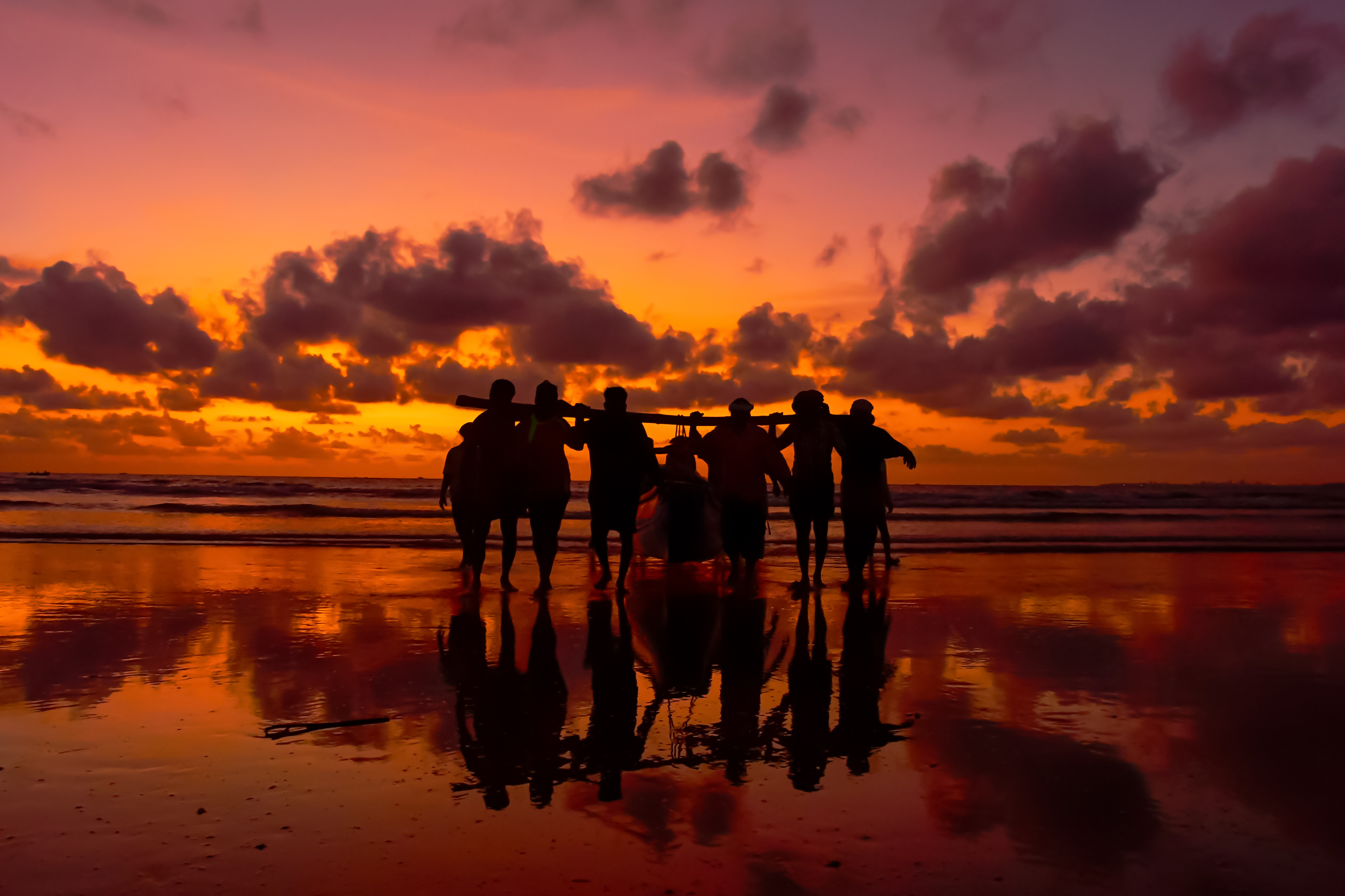
Fishermen at work by Shagil Kannur.jpg

Kerala, IN

Muzhappilangad Beach

India's longest drive-in beach: roughly 4 km of firm sand on the Arabian Sea, with about 3.4 km you can drive a car straight down.

Fishermen at work by Shagil Kannur.jpg · <a href="//commons.wikimedia.org/wiki/User:Shagil_Kannur" class="mw-redirect" title="User:Shagil Kannur">Shagil Kannur</a> · CC BY-SA 4.0
Substrate
sand
Nearest airport
CNN · 18 km
Tier
Featured
I’m here for
Story

Muzhappilangad Beach runs about 3.8 kilometers along the Malabar Coast in Kannur district, Kerala, near Thalassery (Tellicherry). What separates it from the rest of India's coastline is a single permission: you can drive a car onto the sand. Roughly 3.4 kilometers of the strand is firm enough to take road vehicles, and on a dry afternoon the beach fills with sedans, motorcycles, and the occasional bus crawling along the waterline. This is the longest drive-in beach in Asia, and the reason it works is geology rather than policy.

The sand here is quartz-dominant and packs hard when wet, giving tires something to grip that most beaches never offer. Running parallel to the shore, a line of black basalt rocks sits offshore and absorbs the worst of the Arabian Sea's swell. That rock barrier does two jobs at once: it breaks the strong currents that would otherwise scour the beach, and it shelters a shallow stretch of water calm enough to wade and swim in. Without the rocks there would be no firm sand to drive on and no protected lagoon to swim in. The whole character of the place rests on that offshore wall.

About 100 to 200 meters south lies Dharmadam Island, a small green islet locals call Pacha Thuruthu, the Green Island. At low tide it is possible to walk out to it from the adjacent Dharmadam beach across the exposed sand and rock. The island and the beach together form one of the quieter corners of Kerala's tourism map, far from the resort density of the south around Kovalam and Varkala.

The beach earned wider attention in 2016, when BBC Autos named it among the six best beaches in the world for driving. Kerala Tourism has since built it into a destination brand, and every April the village hosts a beach festival with car and bike stunts and cultural programs. Birdwatchers come for a different reason: more than thirty migratory species have been recorded here, and in 2013 a pectoral sandpiper and a Caspian plover were reported for the first time in Kerala.

The drive-in novelty carries its own hazards. The same tide that exposes hard sand returns to cover it, and vehicles that misjudge the timing get stranded or swamped. The protection of the rock barrier ends where the rocks end, and the open water beyond carries the currents the barrier was holding back. Lifeguards and beach wardens now enforce speed limits after past incidents. The beach gives you a coastline you can drive, but it does not pretend the sea has stopped behaving like the sea.

The spike

India's longest drive-in beach: roughly 4 km of firm sand on the Arabian Sea, with about 3.4 km you can drive a car straight down.

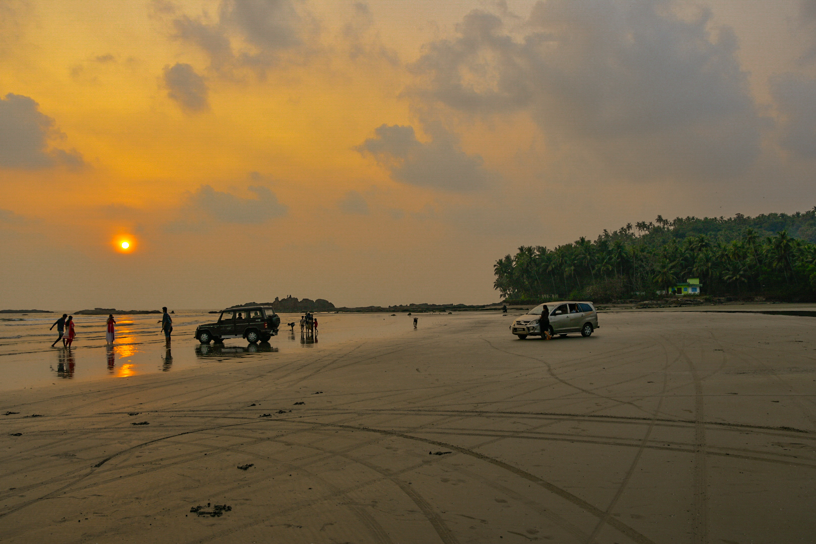
Muzhappilangad is the longest drive-in beach in Asia, and the claim is literal: you can drive an ordinary car onto the sand and travel along the shoreline. About 3.4 kilometers of the roughly 3.8-kilometer beach is firm enough to carry road vehicles, and tourism descriptions commonly round the drivable run to about 4 km. On a dry day at low tide the beach carries sedans, motorcycles, and tour vehicles moving along the waterline of the Arabian Sea.

Why this beach and not the thousands of others. The thing that makes a beach driveable is sand that packs hard enough to hold a tire without giving way. Muzhappilangad's sand is quartz-dominant and compacts when wet, and the beach owes that firmness to the rocks offshore. A line of black basalt runs parallel to the shore and absorbs the strong currents of the Arabian Sea before they reach the sand. Without that barrier the swell would keep the beach loose and scoured; with it, the sand sets firm and a calm, shallow band of water forms behind the rocks. The same feature that makes the beach safe to swim is the feature that makes it firm to drive. Remove the rocks and you lose both at once.

The recognition that built the brand. In 2016 BBC Autos named Muzhappilangad among the six best beaches in the world for driving, and that citation did most of the work of turning a local beach into a national destination. Kerala Tourism now markets it as Asia's longest drive-in beach, and every April a beach festival fills the sand with car and bike stunts and cultural programs. The drive-in identity is not a marketing overlay on an ordinary beach; it is the one thing the beach actually offers that almost no other beach in India does legally.

The hazard built into the novelty. Driving on a tidal beach means driving on a surface the sea takes back twice a day. The firm sand is exposed at low tide and covered at high tide, and vehicles that misjudge the timing or wander onto the soft wet margin near the water get stuck or swamped. The calm lagoon is calm only inside the rock barrier; where the rocks end, the open-sea currents the barrier was holding resume, and swimmers who drift past lose their protection. Beach wardens and lifeguards now enforce speed limits after past incidents, managing the predictable problem of fast vehicles and families on foot sharing one unmarked 3.4-kilometer strip. The beach genuinely lets you drive on sand and swim in sheltered water; it does this by way of tides and rocks that keep working whether or not the visitor is paying attention.

What is nearby. About 100 to 200 meters south sits Dharmadam Island, a small green islet locals call Pacha Thuruthu, walkable at low tide from the adjacent Dharmadam beach. The shore is also a documented birding site, with more than thirty migratory species recorded and a pectoral sandpiper and Caspian plover noted in 2013 as Kerala firsts. The drive is the headline; the island, the birds, and the calm lagoon are what fill the day around it.

Muzhapilangad beach.JPG
Culture

Where it shows up

Other
  • BBC Autos: six best beaches for driving · 2016
    BBC Autos

    In 2016 BBC Autos named Muzhappilangad among the six best beaches in the world for driving, the citation most responsible for its reputation as a driving destination.

  • Annual Muzhappilangad Beach Festival

    Held each April, the beach festival features car and bike stunts on the sand alongside cultural programs, drawing crowds from across Kerala. It is built around the beach's defining drive-in character.

Muzhappilangad Drive-in Beach 2.jpg
History

What happened here

  1. 2013natural

    Rare migratory birds recorded for the first time in Kerala

    A pectoral sandpiper and a Caspian plover are reported at Muzhappilangad, both recorded for the first time in Kerala. The beach is documented as a habitat for over thirty migratory bird species.

    Wikipedia →
  2. 2016cultural

    Named among the world's six best beaches for driving

    BBC Autos features Muzhappilangad among the six best beaches in the world for driving, the recognition most responsible for its profile beyond Kerala.

    Wikipedia →
The honest part
The same firm sand and sheltered water that make Muzhappilangad unique are made by tides and rocks that do not stop working when the cars arrive.

The appeal of Muzhappilangad is also its risk. Driving on a tidal beach means sharing a surface that the Arabian Sea reclaims twice a day, and a car parked too long or pushed too far toward the soft, wet margin can sink to its axles or be caught by a rising tide. The calm lagoon that makes the place safe to swim is calm only where the offshore black rocks break the swell; past the end of that barrier the currents the rocks hold back run strong, and swimmers who drift beyond the sheltered zone lose the protection without warning. Beach wardens and lifeguards now enforce speed limits and crowd control after past accidents, a response to the predictable collision of fast vehicles, families on foot, soft sand, and moving water on a single 3.4-kilometer strip with no lanes. The honest version of the experience is that the same firm sand and sheltered water that make Muzhappilangad unique are produced by tides and rocks that do not stop working when the cars arrive. The beach is genuinely driveable and genuinely swimmable; it is also a place where the ordinary rules of the sea still decide what happens, and where the novelty of driving on sand can flatter a visitor into forgetting them.

Muzhapilangad-Beach.jpg
Anatomy

The shape of the place

Dharmadam Island (Pacha Thuruthu)

0%

A small green islet, locally Pacha Thuruthu or Green Island, roughly 100 to 200 meters south of the beach. Reachable on foot from the adjacent Dharmadam beach at low tide across exposed sand and rock.

Best for A low-tide walk to a private-feeling islet

Walkable only at low tide; the crossing floods as the tide returns.

The drivable strand

50%

The roughly 3.4-kilometer stretch of firm, quartz-dominant sand that road vehicles can drive directly onto, the feature that makes this Asia's longest drive-in beach. Firmest at low tide.

Best for Driving a car or motorcycle on the sand

Drivable only while the tide is out; the soft wet margin near the water traps vehicles, and speed limits are enforced by wardens.

The sheltered swimming water

50%

The shallow, calmer band of water held inside the offshore black-rock barrier, where the swell is broken and wading and swimming are possible.

Best for Swimming and wading inside the rock barrier

Calm only where the rocks break the swell; the protection ends where the barrier ends and open-sea currents resume.

The black basalt barrier

50%

The line of black rocks offshore and bordering the beach that absorbs the Arabian Sea's currents and shelters the lagoon. The rocks also provide habitat for blue mussels.

Best for Understanding why the beach is driveable and swimmable

The rocks are the reason the sand stays firm and the lagoon stays calm; do not mistake the calm for open water beyond them.

Landmarks

The offshore black-rock barrier

natural

A line of black basalt rocks running parallel to the shore that breaks the Arabian Sea's strong currents, shelters a calm swimming lagoon, and keeps the beach sand firm. The rocks also host blue mussels.

Wikipedia →

Dharmadam Island (Pacha Thuruthu)

natural

A small green island about 100 to 200 meters south of the beach, known in Malayalam as Pacha Thuruthu, the Green Island. It can be reached on foot from the nearby Dharmadam beach during low tide.

Wikipedia →
A day here

From first light to dark

Dawn

At low tide in the early morning the wet sand is firmest and the beach is at its widest, before the day's vehicles arrive. Fishermen work the shoreline and the calm water inside the rock barrier lies flat. This is the window birdwatchers favor, walking the shore where more than thirty migratory species have been recorded.

Midday

By late morning cars, motorcycles, and tour vehicles are moving along the 3.4-kilometer drivable stretch. The firm sand carries them while the tide is out; wardens watch speeds and keep drivers off the soft, wet margin near the water. Families wade in the sheltered lagoon behind the black rocks.

Golden hour

Late afternoon brings warm light across the quartz sand and the Arabian Sea, and the heaviest crowds. Vehicles, swimmers, and walkers share the same strip as the sun drops toward the water off the Malabar Coast. The rising tide begins to narrow the driveable band, and drivers start moving back from the waterline.

Night

After dark the beach is largely empty and unlit. The tide covers the sand that was driven on hours earlier, and the rock barrier offshore takes the swell in the dark. There are no facilities on the sand itself; activity moves back to Muzhappilangad village and the road behind the beach.

Before you go

Things to know

Driving

Roughly 3.4 km of the beach is drivable, but only at low tide; keep off the soft wet margin near the water, where vehicles get stuck or swamped.

Swimming

Water is calm and shallow inside the offshore black-rock barrier; currents resume where the rocks end, so stay within the sheltered zone.

Tides

The firm sand is exposed at low tide and covered at high tide; plan driving and the walk to Dharmadam Island around the tide table.

Speed

Beach wardens and lifeguards enforce speed limits after past incidents; cars, motorcycles, swimmers, and walkers share one unmarked strip.

Sharks

No incidents on record in the global shark-attack file.

Plan

If you go

Getting there
Nearest airport
Kannur International Airport (CNN) · 18 km
Nearest town
Mulappilangad · 1 km

The beach is in Kannur district, about 7 km from Thalassery and roughly 17.7 km from Kannur International Airport (CNN). The nearest town is Mulappilangad, 1.2 km away. Vehicles drive directly onto the sand at low tide.

When to go
  • Muzhappilangad Beach Festival · Every April

    An annual beach festival featuring car and bike stunts on the drivable sand, cultural performances, and local programs. It is among the beach's most attended events and leans directly on its drive-in identity.

What to eat & drink
Malabar seafood and fresh catch

Kannur sits on the Malabar Coast, and the regional kitchen runs on the day's fish: mackerel, sardine, and prawn cooked in coconut and the sour fruit kudampuli. Eateries near the beach and in Thalassery and Kannur town serve it fresh rather than as a tourist set piece.

Local eateries in Muzhappilangad, Thalassery (7 km), and Kannur town

Thalassery biryani

A distinct Malabar biryani made with short-grain kaima rice rather than basmati, a specialty of nearby Thalassery (Tellicherry), about 7 km from the beach. It is a documented regional dish, not a recent invention for visitors.

Thalassery and across Kannur district

Kerala tea and snacks

The standard coastal break: strong sweet tea with fried snacks from roadside stalls and small shops behind the beach. Practical fare for a day spent on the sand.

Roadside stalls along the beach road

Sources & references
  1. Wikipedia: Muzhappilangad Beach · cited 7×
  2. Wikipedia: Muzhappilangad Beach; BBC Autos 2016
  3. Kerala Tourism; Wikipedia
  4. Beach data record
Colophon · Provenance

Where this page comes from

Geography, facilities
OpenStreetMap (ODbL) for geometry and facility tags within 500 m of the beach centroid. GeoNames for city/airport distances.
Climate & ocean
Open-Meteo ERA5 + Marine archive, 2014–2023 monthly normals.
Photography
Archival, original tone (Tier B — Wikimedia Commons). Each image licensed per its own terms; attribution visible inline.
History & culture
Every factual claim is linked to its source in the prose above. Wikipedia citations inline. Non-wiki sources named where relevant.
Editorial voice
Register: wry. Written to pass a local's nod test; corrections welcome.
Written by Erin Rose
Last reviewed 2026-04-19
v0.9in editorial development toward v1.0