California, US

Ocean Beach

Path on former Park and Ocean Railroad (1), September 2019.JPG

California, US

Ocean Beach

San Francisco closed a scenic highway for Sunset Dunes park at Ocean Beach in 2025, then voters recalled the supervisor who championed it.

Path on former Park and Ocean Railroad (1), September 2019.JPG · <a href="//commons.wikimedia.org/wiki/User:Pi.1415926535" title="User:Pi.1415926535">Pi.1415926535</a> · CC BY-SA 3.0
Nearest airport
SFO · 20 km
Story

Ocean Beach is a 3.5-mile stretch of Pacific-facing shoreline on the western edge of San Francisco, running from the Cliff House and Sutro Baths area in the north down to Fort Funston in the south. It is administered by the National Park Service as part of the Golden Gate National Recreation Area. Some geocoded datasets list the nearest city as Daly City, a few kilometers to the south; that is a mapping artifact, not a statement about jurisdiction — the beach sits squarely inside San Francisco proper. Longtime surfers still call the northern section, near the Cliff House, Kelly's Cove, and the corridor that used to carry the Great Highway along the beach's inland edge is now partly known as Sunset Dunes.

This is not a swimming beach in any conventional sense. The water is cold year-round, the surf is exposed to the open Pacific, and the currents move at noticeably different speeds along the shoreline — fast where the inlet narrows, calmer at the north end, and slowest of all at the south end. Sand dollars of the species Dendraster excentricus regularly wash up and blanket long stretches of sand. In recent decades, bottlenose dolphins — a species traditionally associated with Southern California and Baja California — have moved north into these waters as ocean temperatures have risen.

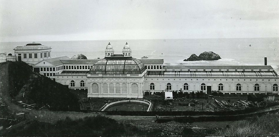
The beach has drawn crowds for well over a century. The Cliff House and Sutro Baths turned this corner of the city into a resort destination in the nineteenth century; both are long gone in their original form, and the amusement-park era that followed them had ended by 1972. Jack O'Neill opened his first surf shop here, and the beach later hosted the day Kelly Slater won his only ASP world surfing title on continental U.S. soil. Fuller dates and sources for all of it are in the timeline below.

Most recently, San Francisco closed the stretch of Great Highway that ran along Ocean Beach and replaced it with a new park, Sunset Dunes — a change popular enough to draw large crowds on its first day, and controversial enough to end a sitting supervisor's career within the year. The full story of how that happened is below.

None of this makes Ocean Beach an easy or reassuring place. It draws well over a million visitors a year to a shoreline the agency that runs it has deliberately declined to lifeguard, in front of a wastewater plant the city is now racing shifting sand to protect with one of the largest seawalls ever proposed in California. What follows lays out the numbers, the history, and the reasoning behind both.
The spike

San Francisco closed a scenic highway for Sunset Dunes park at Ocean Beach in 2025, then voters recalled the supervisor who championed it.

Ocean Beach's biggest recent change wasn't to the sand. It was to the road running alongside it.

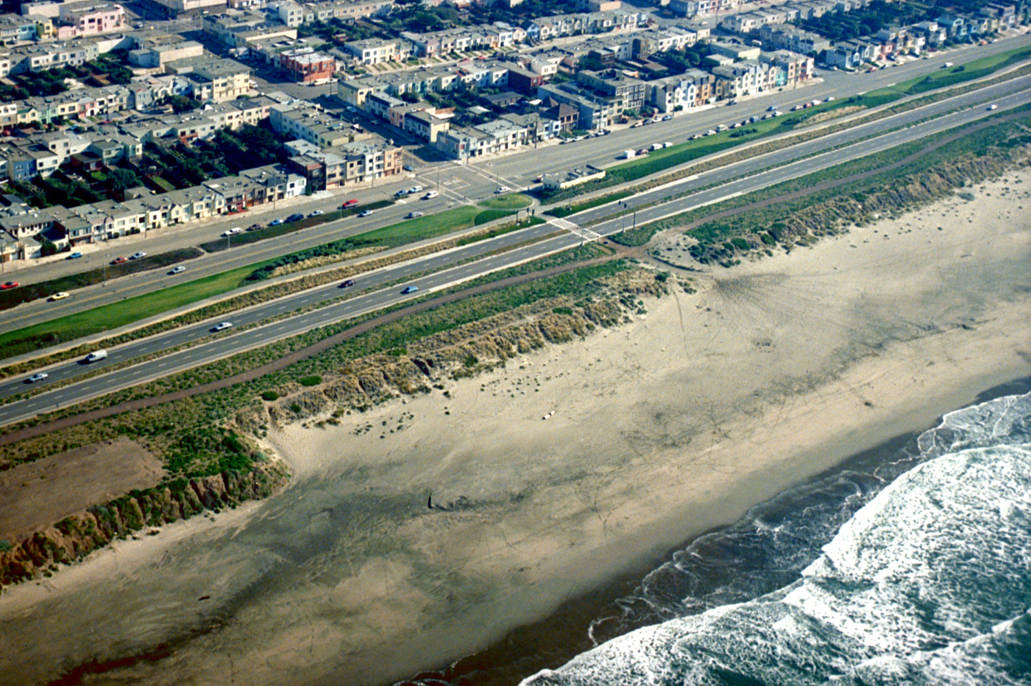
What actually closed. In March 2025, the stretch of the Great Highway between Lincoln Boulevard and Sloat Boulevard — the road that had run along Ocean Beach's inland edge for decades — was permanently closed to cars. The closure followed the passage of Proposition K, a San Francisco ballot measure. As part of the changeover, the city moved roughly 40,000 cubic yards of sand from the north side of the beach to the south side. The resulting park, built on the old roadbed, was named Sunset Dunes, and it officially opened to the public on April 12, 2025.

The park was popular immediately. On opening day, 13,000 people showed up to walk, bike, and skate a stretch of pavement that had carried car traffic a few weeks earlier. A dedicated skateboarding area within the park opened that June. For a project that had been fought over for years before it happened, that turnout sent a clear signal: whatever the arguments against closing the highway, a large number of people wanted to use the space once it existed as a park instead of a road.

The politics did not follow the popularity. Joel Engardio, the San Francisco district supervisor who had championed the highway closure and Sunset Dunes, was recalled from office in September 2025, in what reporting on the episode described as a direct reaction to his support for the project. The timing is the whole story here: a park that thirteen thousand people showed up to enjoy on its very first day still was not enough to save the political career of the person who had fought hardest to build it. Popularity and political survival turned out to be two different currencies, and Engardio spent the wrong one.

Opponents kept fighting after the recall. A lawsuit sought to undo Proposition K entirely and reopen the Great Highway to car traffic. In January 2026, San Francisco Superior Court Judge Jeffrey Ross rejected that lawsuit, leaving the closure and Sunset Dunes in place. So the park survived its legal challenge even after its single most visible political champion did not survive his recall — the policy outlasted the politician who built his career on it.

The economic verdict is still unsettled. As of March 2026, businesses along the former Great Highway corridor were reporting inconsistent results: some told reporters their sales had increased since the park opened, while others described the change as minor or negligible. There is no single, settled answer yet on whether Sunset Dunes has been good or bad for the businesses along its edge — only a scatter of individual experiences that have not converged into a clear pattern one way or the other.

The timing wasn't a coincidence. Sunset Dunes sits on top of the same shifting, eroding sand that has forced the city into a much larger, separate fight over a proposed seawall at the beach's south end, meant to protect a wastewater treatment plant from the ocean. That fight — over the sand itself rather than the road above it — was already underway before the highway closed, and it is still unresolved; it is covered on its own in the environment deep dive linked from this page, because it is a genuinely different argument with its own timeline and its own unanswered questions.

Why this matters beyond San Francisco. Sunset Dunes is a case study in a fight playing out in coastal cities everywhere: a road built for cars, running along an eroding, high-value shoreline, that a city decides to hand back to people instead. Nearly every version of that fight has the same three pressure points — an organized, vocal opposition that valued the road as it was; a public that shows up once given something better than a road, whether or not that same public organized to build it; and an economic verdict that arrives slower and messier than the political one. San Francisco's version compressed all three into about six months: the highway closed in March 2025, the park opened weeks later to strong turnout, and by September its most prominent backer had lost his job over it. Whether that trade — a popular public space for a politician's career — looks worth it a few years from now depends on facts nobody has yet: whether the mixed business results settle into a clear pattern, whether the recall changes how the next supervisor handles a similar fight, and whether the sand under Sunset Dunes behaves any better than the sand under the highway did. For now, what is verifiable is only this: the road is gone, the park is open, the lawsuit to reverse it failed, and the man who pushed hardest for all of it is out of office.

Ocean Beach San Francisco aerial view.jpg
History

What happened here

  1. 1863development

    The Cliff House opens

    The original Cliff House opens above Ocean Beach, an early anchor of the resort era that later included Sutro Baths.

    Wikipedia →
  2. 1896development

    Sutro Baths open

    Sutro Baths opens beside the Cliff House, drawing thousands more visitors to Ocean Beach.

    Wikipedia →
  3. 1952culture

    Jack O'Neill opens his first surf shop

    Jack O'Neill opens his first surf shop at Ocean Beach, an early root of the city's surf culture.

    Wikipedia →
  4. 1966loss

    Sutro Baths destroyed

    Sutro Baths are destroyed, ending the resort's original form; the neighborhood's amusement-park era closes out by 1972.

    Wikipedia →
  5. 1993policy

    Western snowy plover listed as threatened

    The U.S. Fish and Wildlife Service lists the western snowy plover, which rests at Ocean Beach, as federally threatened.

  6. 2011sport

    Kelly Slater wins his 11th world title at Ocean Beach

    The Rip Curl Pro at Ocean Beach is the site of Kelly Slater's 11th ASP world championship, his only title won in the continental U.S.

    Wikipedia →
  7. 2024policy

    State approves $175 million seawall plan

    The California Coastal Commission approves a $175 million plan for one of the largest seawalls in state history at south Ocean Beach.

  8. 2025policy

    Great Highway closes to traffic

    The Great Highway between Lincoln and Sloat boulevards permanently closes to cars under Proposition K.

    Wikipedia →
  9. 2025development

    Sunset Dunes park opens

    The new Sunset Dunes park officially opens on the former highway roadbed; 13,000 people visit on opening day.

    Wikipedia →
  10. 2025governance

    Supervisor Joel Engardio recalled

    Supervisor Joel Engardio is recalled from office, a reaction to his support for Sunset Dunes.

    Wikipedia →
Sutro Baths in San Francisco.jpg
Anatomy

The shape of the place

Cliff House / Sutro Baths area (north end)

5%

The northern anchor of Ocean Beach, historically the site of the Cliff House and Sutro Baths resort complex; ruins and viewpoints remain.

Best for History and coastal views

Kelly's Cove

20%

The northern surf section, a local alias for this part of Ocean Beach and the location of the 2011 Rip Curl Pro that Kelly Slater won.

Best for Surfing and watching surfers

Currents can exceed 2.5 m/s in the inlet throat nearby.

Sunset Dunes park corridor

55%

The former Great Highway roadbed between Lincoln and Sloat boulevards, closed to cars in March 2025 and reopened as Sunset Dunes park weeks later.

Best for Walking, biking, and the skate area that opened in June 2025

South end toward Fort Funston

90%

The calmer, slower-current southern stretch of the beach, inside the snowy plover protection area that runs from stairwell 21 to Sloat Boulevard.

Best for Quieter walking and birdwatching

Currents here run around 0.5 m/s, slowest along the beach; dogs must be leashed here from July 1 through May 15.

Landmarks

California's first lifesaving station · 1878

historic site

Established at the northwest corner of Golden Gate Park facing Ocean Beach, this was California's first lifesaving station; it remained operational until November 1951.

Site of Playland at the Beach · 1926

former amusement park

An amusement park that operated at Ocean Beach from 1926 to 1972, later replaced by apartment blocks and a supermarket; the It's-It ice cream sandwich was invented here as a park snack.

"Carville" streetcar community site · 1895

historic settlement

Starting in 1895, Adolph Sutro sold oceanside lots where residents parked retired horse-drawn streetcars, forming an informal community near Ocean Beach known as Carville.

A day here

From first light to dark

Dawn

Fog usually still covers the dune line at first light, and the corridor once occupied by the Great Highway is close to empty. Early walkers and a handful of surfers have Kelly's Cove to themselves before the wind picks up.

Midday

By midday the marine layer often thins enough to see the Cliff House ruins to the north and the bluffs toward Fort Funston to the south, though the currents stay dangerous no matter how calm the surface looks.

Golden hour

Sunset over the open Pacific is the beach's most reliable payoff, and the widened dune line at Sunset Dunes fills with photographers and dog walkers as the light changes.

Night

After dark the beach empties out except for permitted bonfires at designated fire rings; the rest of the sand is unlit, and any water entry after sundown is considerably more dangerous than during the day.

Shipwreck at Ocean Beach.jpg
Culture

Where it shows up

History
  • Wreck of the King Philip · 1878

    The three-masted clipper ship King Philip drifted onto Ocean Beach and foundered on January 25, 1878; its wreckage has resurfaced periodically since, most recently in November 2010.

  • Jack Johnson's training ground

    Jack Johnson, the first African American world heavyweight boxing champion, trained at the Ocean Beach Pavilion in the early 1900s ahead of some of his famous fights.

  • First parachute jump in America · 1887
    Thomas Baldwin

    Thomas Baldwin made the first parachute jump in America in 1887, launched from a hot air balloon that departed from Ocean Beach near the Cliff House.

Brand & advertising
  • It's-It ice cream sandwich

    The It's-It ice cream confection was invented as a snack at Playland at the Beach, the amusement park that once stood at Ocean Beach.

The honest part
“"It's not a swimming beach. We don't advise that anyone enter the water there."”

Ocean Beach has been called California's deadliest beach, and the agency that runs it has made a deliberate choice not to fix that the way lifeguarded beaches do. The National Park Service has not installed lifeguard towers at Ocean Beach. A supervising park ranger for the agency put the reasoning plainly: "It's not a swimming beach. We don't advise that anyone enter the water there." The strategy, in effect, is to let the beach look and feel dangerous enough that people stay out of the water, rather than staff it so that people can swim there more safely. Reporting based on National Weather Service data found the beach had claimed eight lives since 2014, more than any other beach in California; 1998 was the worst single year on record, with seven deaths. A surfer, Kirby Lee, died in a surfing accident there in November 2023, a reminder that the danger is not only historical.

That is the trade the agency has made, and it is worth naming without softening it: more than a million people visit Ocean Beach every year, and the official safety plan for a beach that popular is, essentially, discouragement rather than supervision. It may be the right call given the currents involved — reducing false confidence can save lives that a staffed but overmatched lifeguard post might not — but it is also a choice that puts the entire burden of judgment on visitors who often have no way of knowing how genuinely dangerous the water in front of them is.

San Francisco Ocean Beach 01.jpg
Sea & surf

What the water does

JFMAMJJASONDmetres (significant wave height)

Solid = typical monthly wave height; pale = the bigger days (90th pct). Offshore/regional swell from Open-Meteo Marine (ERA5 Ocean reanalysis, 2023–2024); a sheltered cove may sit calmer than this.

Exposed — real surf, and rip current to respect
Typical wave height
1.76 m
Biggest swell
Jan · 2.55 m
Calmest
Aug · 1.16 m
Typical period
10.6 s (groundswell)
Before you go

Things to know

No lifeguard towers

The National Park Service has deliberately chosen not to install lifeguard towers at Ocean Beach, reasoning that an unmistakably dangerous-looking beach keeps more people out of the water than a staffed one would.

Leash law

Dogs must be leashed from July 1 through May 15 within the snowy plover protection area, which runs from stairwell 21 to Sloat Boulevard and extends 1,000 feet offshore.

Fires

Beach fires are permitted only March 1 through October 31, and only in the provided fire rings between stairwells 15 and 20.

Getting there

On-site parking is very limited; the park service recommends public transportation, including the Muni Metro stop at Judah and La Playa.

Surf & rip

Powerful water — strongest around Jan, gentlest in Aug. Mind rip currents; this isn't a wade-in-anywhere beach.

Sharks

No incidents on record in the global shark-attack file.

Plan

If you go

Getting there
Nearest airport
San Francisco International Airport (SFO) · 20 km
Nearest town
Daly City · 8 km

Ocean Beach runs along San Francisco's Pacific edge from the Cliff House/Sutro Baths area south to Fort Funston, paralleled by the Great Highway/Sunset Dunes corridor. The Muni Metro stop at Judah and La Playa reaches the beach directly; on-site parking is very limited, and the National Park Service recommends arriving by public transit. Straight-line distance to San Francisco International Airport (SFO) is 20.2 km; no source behind this page gives the road distance or drive time.

When to go
  • Permitted beach bonfires · Daily, 6:30am–9:30pm, March 1 through October 31

    Fires are allowed only in provided fire rings between stairwells 15 and 20, and only during the permitted season.

  • Sunset Dunes cleanup volunteer event · Listed for September 13, 2026, 1–3pm

    A community cleanup event for the new Sunset Dunes park; the sheet behind this page captured a single dated listing and cannot confirm how often it recurs.

What to eat & drink
It's-It ice cream sandwich

This oatmeal-cookie-and-ice-cream confection was invented as a snack at Playland at the Beach, the amusement park that operated at Ocean Beach from 1926 to 1972. It survives today as a Bay Area grocery product, though no stand sells it at the beach itself.

Originated at the former Playland at the Beach site; sold today off-site at Bay Area grocers

Bonfire cooking

There is no food service on the sand. The closest thing to dining at the beach itself is a permitted fire ring, where visitors bring and cook their own food during the allowed season.

Designated fire rings on the beach, permitted seasonally

No on-beach vendors

The sheet behind this page found no verifiable, currently operating restaurant, cafe, or surf-shop name for Ocean Beach itself; nearby inland neighborhoods have their own dining options not covered here.

Inland of the beach, in the surrounding San Francisco neighborhoods

Go deeper
Sources & references
  1. Wikipedia · cited 11×
  2. SF Standard, June 2026 · cited 3×
  3. SFGate, 2018 · cited 2×
  4. SF Standard, 2022
  5. SFGate, 2018 (NWS data)
Colophon · Provenance

Where this page comes from

Geography, facilities
OpenStreetMap (ODbL) for geometry and facility tags within 500 m of the beach centroid. GeoNames for city/airport distances.
Climate & ocean
Open-Meteo ERA5 + Marine archive, 2014–2023 monthly normals.
Photography
Archival, original tone (Tier B — Wikimedia Commons). Each image licensed per its own terms; attribution visible inline.
History & culture
Every factual claim is linked to its source in the prose above. Wikipedia citations inline. Non-wiki sources named where relevant.
Editorial voice
Register: wry. Written to pass a local's nod test; corrections welcome.
Written by Erin Rose
Last reviewed 2026-04-19
v0.9 — in editorial development toward v1.0