California, US

Pfeiffer Beach

Pfeiffer Beach at Dusk (Unsplash).jpg

California, US

Pfeiffer Beach

Garnet eroding from the schist of Pfeiffer Ridge streaks Pfeiffer Beach purple, and near the winter solstice the setting sun lines up through Keyhole Arch.

Pfeiffer Beach at Dusk (Unsplash).jpg · Kace Rodriguez <a rel="nofollow" class="external text" href="http://unsplash.com/@kace">kace</a> · CC0
Spring tide
1.25 m
Nearest airport
MRY · 39 km
Tier
Featured
I’m here for
Story

Pfeiffer Beach is a Forest Service cove on the Big Sur coast of Monterey County, California, reached only by Sycamore Canyon Road — an unmarked single-lane turnoff west of Highway 1, a couple of miles south of Pfeiffer Big Sur State Park. There is no sign for it on the highway. The road runs about 2.2 miles down a narrow canyon to a lot of roughly 65 spaces; RVs and trailers cannot fit, and the Forest Service prohibits walking down the road. That access is the whole reason the beach stays as it is: you either find the turnoff and get a space, or you do not go.

What the road delivers is a beach with two singular things. First, the sand is streaked purple. Pfeiffer Ridge rises roughly 1,600 feet directly behind the cove, and its schist carries manganese garnet; as the slope erodes, the heavy garnet grains wash down and the surf sorts them into violet seams across the ordinary tan quartz sand. The color is strongest after rain. Most of the sand is still quartz — the purple is the garnet fraction settling out.

Second, there is Keyhole Arch, a sea-stack with a hole worn through it standing just off the sand. For most of the year it is a photogenic rock. But for a limited run of days around the winter solstice — roughly December into January — the setting sun drops low enough to line up behind the opening and fire a beam of light straight through the keyhole. On those evenings the small beach fills with photographers and tripods, all aimed at the same rock.

The name comes from the Pfeiffer family, who in the winter of 1869 were heading for the south Big Sur coast and were forced to stop for the season in Sycamore Canyon — Michael and Barbara Pfeiffer, the first European settlers to homestead this stretch. Their son John later donated 700 acres that became Pfeiffer Big Sur State Park. The land was the Esselen people's first; a midden site survives near the original Pfeiffer home. The beach itself is now day-use land in Los Padres National Forest.

None of this is swimming water. The Forest Service warns plainly that swimming here can be hazardous from cold water, rocks, and unpredictable riptide currents. The Pacific along this coast runs roughly 55-60°F year-round and breaks hard against the stacks. From June to August the cove is often fogged in — the local 'June Gloom' — so the purple-and-amber postcard beach is, much of the year, grey, windy, and no place to get in the water.

The spike

Garnet eroding from the schist of Pfeiffer Ridge streaks Pfeiffer Beach purple, and near the winter solstice the setting sun lines up through Keyhole Arch.

Two things make Pfeiffer Beach singular, and both come straight off the geology of the ridge behind it. The first is the purple sand. The second is the few days a year when the sun fires through Keyhole Arch. Neither is a trick of marketing; both are consequences of where the beach sits and what the hills are made of.

The purple is garnet, and the garnet comes off the cliff. Directly behind the cove, Pfeiffer Ridge rises to roughly 1,600 feet. The metamorphic rock of that ridge — schist, formed when older rock was cooked and squeezed under heat and pressure — carries manganese garnet. Garnet is a heavy, hard mineral that resists weathering far better than the quartz around it. As rain and runoff erode the slope, the garnet grains wash down the hillside toward the beach. Once they reach the sand, the waves and the wind do the sorting: the heavy garnet drops out and concentrates while lighter quartz is carried off, so the garnet collects in streaks and seams. That is why the purple is never an even wash across the whole beach but a pattern of violet ribbons threaded through tan sand, strongest in the low spots where water has run, and most vivid after a storm has freshly delivered material off the ridge. Most of the sand at Pfeiffer is still ordinary quartz; the purple is the heavy-mineral fraction, garnet plus other dense grains, settling out of the mix.

The exact name of the mineral is where sources start to disagree, and it is worth being honest about that. Popular accounts call it 'manganese garnet,' and many reach for the gem-trade name *almandine* — but almandine is the iron-rich garnet, not the manganese one. The manganese garnet is properly *spessartine*. Different writers use different names, and without a published mineralogical assay of Pfeiffer's specific sand it is fair to say only this: the purple grains are garnet derived from the metamorphic rock of Pfeiffer Ridge, rich enough in the heavy mineral to color the beach, and the precise species is reported inconsistently. The mechanism — heavy garnet eroding off a steep ridge and sorting onto the sand — is not in dispute. The label is.

The second feature, Keyhole Arch, is an alignment, not a permanent show. A weathered sea-stack stands just off the beach with a hole worn clean through it. For most of the year the sun sets too far north on the horizon for its light to pass through the opening from the angle the beach offers. But the sun's setting point swings south through autumn toward the winter solstice in late December, when it sets at its southernmost. For a limited window around the solstice — reported as a handful of days spread across December and January — the low setting sun lines up behind the keyhole and, if the evening is clear and the surf is throwing spray, sends a defined beam of orange light through the gap. It needs the calendar, a clear western horizon, and luck with fog all at once, which is why the photographs are prized and why those specific evenings draw crowds to a beach that is otherwise hard to reach and often empty.

The access is the third character in the story, and it shapes everything. Pfeiffer Beach is one of the few points where you can actually reach the ocean along the Big Sur coast, where the terrain is otherwise too steep for shore access. You get there on Sycamore Canyon Road, an unmarked single-lane turnoff west off Highway 1, a couple of miles south of the Big Sur River and Pfeiffer Big Sur State Park. There is no sign on the highway; first-timers routinely drive past it. The road runs about 2.2 miles of narrow, winding pavement down to a lot the Forest Service rates at about 65 vehicles. RVs and trailers cannot use it — the road is too narrow. And because the road cannot safely share its width between cars and people on foot, walking down it is prohibited; if the lot is full, on a busy day cars stack up at the top of the canyon waiting two miles above for a space to open below. The beach's calm is rationed by a parking lot at the bottom of a one-lane canyon.

The human history runs through that same canyon. The Pfeiffer family — Michael and Barbara — were bound for the south Big Sur coast in the winter of 1869 when weather forced them to stop in Sycamore Canyon for the season; they became the first European settlers to homestead this part of the coast, and the beach, the canyon road, and the nearby state park all carry their name. Their son John Pfeiffer later donated 700 acres of his land, which became Pfeiffer Big Sur State Park. Before any of that, this was Esselen land, and an archaeological midden survives near the site of the original Pfeiffer home. The cove is now Los Padres National Forest day-use ground, charging a fee per vehicle and open through daylight hours.

And none of it is a swimming beach. The Forest Service is explicit that swimming can be hazardous because of cold water, rocks, and unpredictable riptide currents. The water runs cold all year, the surf breaks heavily against the stacks, and from June to August the cove is frequently fogged in — the 'June Gloom' that hangs over the Big Sur coast in summer. The singular things about Pfeiffer — the garnet streaks and the solstice beam — are things to look at, not to swim in. The honest version is a beautiful, cold, dangerous, hard-to-reach cove whose two famous features depend on the same ridge that towers behind it and the same Pacific that makes the water unsafe.

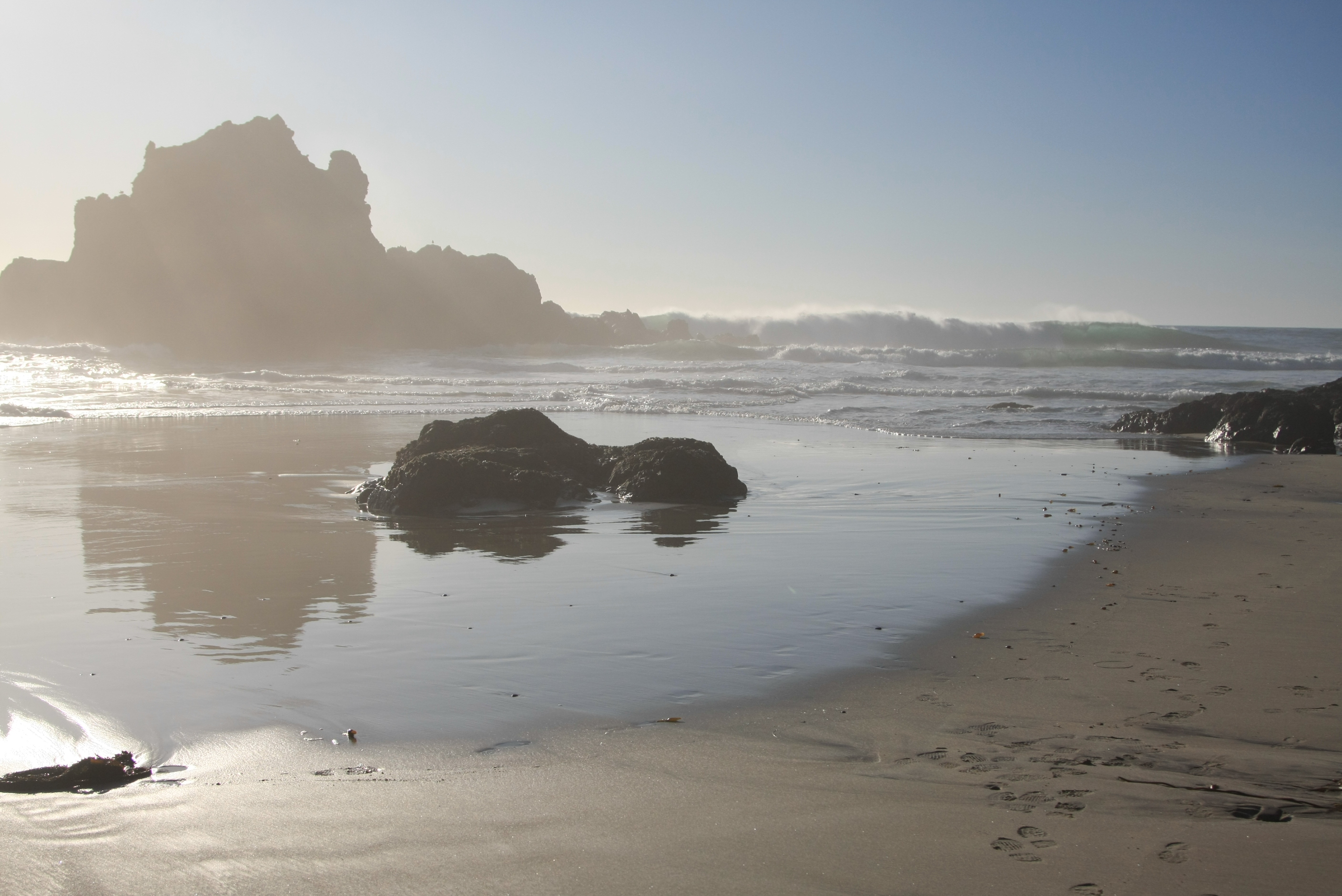
Pfeiffer State Beach Reflection.JPG
Culture

Where it shows up

History
  • Esselen midden near the original Pfeiffer home

    Before European settlement this was Esselen land, and an archaeological midden — an accumulation of shell and refuse marking long Indigenous use of the coast — survives near the site of the original Pfeiffer home in the canyon behind the beach.

Literature
  • Big Sur · 1962
    Jack Kerouac

    Kerouac's 1962 novel 'Big Sur' is set on this coast around Bixby Canyon and the Big Sur cabins of his circle, fixing the area in American literary imagination as a place people retreat to. It is a portrait of the wider coast, not of Pfeiffer Beach specifically.

  • The Pfeiffer family in Big Sur history · 1869

    The Pfeiffers became the namesake settler family of the Big Sur coast after wintering in Sycamore Canyon in 1869. Their homestead and John Pfeiffer's later land donation tie the beach, the canyon, and the state park together under one name.

Other
  • Purple sand

    Pfeiffer Beach is one of the most cited examples of garnet-stained 'purple sand' worldwide, the phenomenon where heavy garnet grains eroding off nearby rock concentrate on a beach and tint it violet. The mechanism is well documented even where the exact garnet species is reported inconsistently.

Pfieffer Beach.jpg
History

What happened here

  1. 1869history

    The Pfeiffer family winters in Sycamore Canyon

    Michael and Barbara Pfeiffer, bound for the south Big Sur coast, were forced to stop for the season in Sycamore Canyon in the winter of 1869, becoming the first European settlers to homestead this stretch of coast. The beach, the canyon road, and the state park all carry their name.

    Wikipedia →
  2. 1884history

    John Pfeiffer builds a cabin on the Big Sur River

    John Pfeiffer, son of Michael and Barbara, and his wife Zulema Florence Swetnam built a cabin near the north bank of the Big Sur River, extending the family's homestead in the canyon behind the beach.

    Wikipedia →
  3. 1910development

    Pfeiffer Ranch Resort established

    The Pfeiffer family opened the Pfeiffer Ranch Resort at their home, an early example of Big Sur turning from homestead frontier toward the tourism that now defines the coast.

    Wikipedia →
  4. 1933policy

    John Pfeiffer's land becomes Pfeiffer Big Sur State Park

    John Pfeiffer donated 700 acres of his land rather than see it subdivided, and it became Pfeiffer Big Sur State Park — the state park just up the canyon from the beach that shares the family name.

    Wikipedia →
  5. 1937development

    Highway 1 through Big Sur opens

    The Carmel-San Simeon Highway (Highway 1) through Big Sur was completed and opened in June 1937 after roughly 18 years of construction, finally making the Pfeiffer coast and its beach reachable by car — and beginning the access pressures that still define the cove.

    Wikipedia →
  6. 2017nature

    Pfeiffer Canyon Bridge fails, severing Highway 1

    Storm damage in February 2017 destroyed the Pfeiffer Canyon Bridge on Highway 1 just north of the beach, cutting the coast in two and stranding the Big Sur community for months — a stark example of how readily slides and washouts sever access to Pfeiffer Beach.

    Wikipedia →
  7. 2024nature

    Highway 1 slide at Rocky Creek closes the coast again

    A section of Highway 1 collapsed near Rocky Creek in spring 2024, again closing the road through Big Sur and demonstrating the recurring pattern: when Highway 1 slides, beaches like Pfeiffer become unreachable until repairs reopen the route.

    Wikipedia →
The honest part
The garnet streaks and the solstice beam are things to look at, not to swim in — the water is cold, rock-strewn, riptide-prone, and unguarded.

Pfeiffer Beach is not a swimming beach, and the people who treat it like one are the ones who get hurt. The Forest Service warns that the water is hazardous from cold, rocks, and unpredictable riptide currents; the Pacific here runs roughly 55-60°F all year and breaks hard against the rock stacks, with no lifeguard on duty. The second, slower problem is the access itself. The cove is one of the only ocean access points on a coast otherwise too steep to reach the water, so it funnels everyone down one unmarked, single-lane canyon road to a lot of about 65 spaces. On a clear winter evening when the sun is due to line up through Keyhole Arch, or on a warm summer weekend, that lot fills and cars back up two miles to the top of the canyon, and walking down the road is forbidden because it is too narrow and steep. The same Big Sur coast that makes the beach worth the drive also closes it: Highway 1 slides, washouts, and wildfire repeatedly sever the route, and when the highway is cut the beach is simply unreachable.

Portal of the Sun, Pfeiffer Beach, Big Sur, California.jpg
Anatomy

The shape of the place

Parking lot and trail to the sand

5%

The roughly 65-space Forest Service lot at the bottom of Sycamore Canyon Road, with a short trail down to the beach, a few picnic tables, and no potable water. The chokepoint that rations access to the whole cove.

Best for Arriving, the fee station, the short walk to the sand

Fills on weekends and in summer; when full, cars back up the canyon and there is no walk-in alternative since walking the road is prohibited.

Keyhole Arch and the offshore stacks

30%

The weathered sea-stack with a hole worn through it, standing just off the sand, surrounded by smaller rock stacks the surf breaks against. The beach's signature feature and the focus of the winter-solstice light.

Best for Photography, watching the surf drive through the arch, the December-January sunset beam

The water around the stacks is cold and the riptides unpredictable — admire from the sand, do not swim out to the rocks.

The purple sand streaks

55%

The stretches of beach where garnet washed off Pfeiffer Ridge has been sorted by the surf into violet seams threaded through the tan quartz sand. Strongest in the low spots where runoff concentrates and most vivid after rain.

Best for Seeing the purple sand up close, beachcombing the heavy-mineral seams

The color shifts with weather, tide, and recent storms; on a dry, scuffed afternoon it can be muted. Do not dig up or remove the sand.

Landmarks

Keyhole Arch (Keyhole Rock)

natural

A sea-stack just off Pfeiffer Beach with a hole worn clean through it by the surf. For a limited run of days around the winter solstice, the low setting sun aligns to fire a beam of light through the opening — one of Big Sur's most photographed sights.

Wikipedia →

Pfeiffer Ridge

natural

The ridge rising roughly 1,600 feet directly behind the cove. Its schist carries the manganese garnet that erodes down the slope and gives the beach its purple-streaked sand — the source of the beach's signature feature.

Pfeiffer Big Sur State Park · 1933

park · California State Parks (from John Pfeiffer land donation)

The state park up the canyon from the beach, formed in 1933 from 700 acres John Pfeiffer donated rather than see subdivided. It shares the family name but is a separate, inland redwood park — not the beach, which is Forest Service land.

Wikipedia →
A day here

From first light to dark

Dawn

Early, before the lot fills, the canyon road is empty and the cove is quiet — but on the Big Sur coast a summer morning is as likely to be fogged grey ('June Gloom') as clear. The garnet streaks read deepest where the night's damp still darkens the sand, before foot traffic scuffs them flat.

Midday

By midday on a clear weekend the ~65-space lot is full and cars are stacking at the top of the canyon two miles above. The beach is for walking, beachcombing the purple seams, and watching the surf hit Keyhole Arch and the stacks — not for swimming; the water is cold and the riptides unpredictable.

Golden hour

Late afternoon is when Pfeiffer earns its reputation. Most of the year the sun simply sets behind the stacks; but on the handful of days around the winter solstice the low sun lines up to throw a beam clean through Keyhole Arch, and the small beach fills with photographers aimed at one rock.

Night

The lot closes around 8 p.m. and the gate shuts; there is no camping, no fires, no potable water, and the single-lane road out is unlit. After dark this is a remote cove at the bottom of a steep canyon, a long way from help if the highway above is cut by a slide.

Compare

How it ranks

Peak warmth
Cooler than 93% of beaches in its country
Peak-month high ≈ 21°C
Beach season
Longer beach season than 61% of beaches in its country
6 comfortable months a year

Ranked against every beach in our database — 228,000+ worldwide.

Pfeiffer State Beach Sunset.JPG
Sea & surf

What the water does

JFMAMJJASONDmetres (significant wave height)

Solid = typical monthly wave height; pale = the bigger days (90th pct). Offshore/regional swell from Open-Meteo Marine (ERA5 Ocean reanalysis, 2023–2024); a sheltered cove may sit calmer than this.

Heavy — a powerful, surf-driven coast
Typical wave height
2.3 m
Biggest swell
Jan · 3.24 m
Calmest
Aug · 1.47 m
Typical period
11 s (groundswell)
Before you go

Things to know

The turnoff is unmarked — find Sycamore Canyon Road

There is no Highway 1 sign for the beach. Look for Sycamore Canyon Road, an unmarked single-lane turnoff west off Highway 1 south of Pfeiffer Big Sur State Park (near mile marker MON 45.6), then drive about 2.2 miles down to the lot. RVs and trailers cannot fit.

Pay the fee, arrive early, expect a wait

Los Padres National Forest charges $15 per vehicle (cash recommended as backup) for the roughly 65-space lot. It fills on weekends, in summer, and on clear solstice evenings; when full, cars stack up the canyon and you cannot walk in — walking the narrow road is prohibited.

Do not swim — it is a look-only beach

The Forest Service warns of cold water, rocks, and unpredictable riptide currents; the Pacific here runs about 55-60°F year-round and there is no lifeguard. Beachcomb and photograph, but stay out of the surf and off the wet rocks around the stacks.

Bring everything; pack out everything

No potable water, no food, a few picnic tables only; no camping or fires. Carry in water and supplies and carry all trash back out. And check Highway 1 status before you go — slides, washouts, and fire repeatedly close the only road to Big Sur.

Surf & rip

Powerful water — strongest around Jan, gentlest in Aug. Mind rip currents; this isn't a wade-in-anywhere beach.

Sharks

No incidents on record in the global shark-attack file.

Plan

If you go

Getting there
Nearest airport
Monterey Regional Airport (MRY) · 39 km
Nearest town
Carmel Valley Village · 30 km

Pfeiffer Beach is reached only by Sycamore Canyon Road, an unmarked single-lane turnoff on the west side of Highway 1, about two miles south of Pfeiffer Big Sur State Park (near mile marker MON 45.6) — there is no highway sign, so watch your odometer. The road runs roughly 2.2 miles of narrow, winding pavement down to a Forest Service lot of about 65 spaces; RVs and trailers cannot use it, and walking down the road is prohibited because it is too narrow and steep. The day-use fee is $15 per vehicle (cash recommended as backup; a $50 annual Parks Management Company pass also works), and the gate is open daylight hours, about 9 a.m. to 8 p.m. There is no potable water, no food, and a few picnic tables; bring what you need and carry trash out. The lot fills on summer weekends and on the clear winter evenings when the sun lines up through Keyhole Arch, and when full there is no walk-in alternative. Before setting out, check Highway 1's status — slides, washouts, and wildfire repeatedly sever the route through Big Sur.

When to go
  • Keyhole Arch winter-solstice sunset photography · A limited run of days roughly mid-December through mid-January, clear evenings near low tide

    For a few days around the winter solstice the low setting sun lines up to throw a beam through Keyhole Arch. Word has spread, so on the best clear evenings the small beach and its ~65-space lot fill with photographers and tripods — capacity, fog, and the single-lane road all working against the crowd.

  • Summer 'June Gloom' fog season · Roughly June to August

    From June to August the Big Sur coast is often fogged in and cold — 'June Gloom' locally — so the purple-and-amber picture-postcard beach is, through much of the warm season, grey, damp, and wind-chilled, with the sun burning off only later in the day if at all.

What to eat & drink
Nothing on the beach — pack it in

Pfeiffer Beach is Forest Service day-use ground with a few picnic tables, no potable water, and no kiosk or food of any kind. Whatever you eat or drink, you carry in down the canyon and carry the trash back out. Plan to be self-sufficient.

On the sand at Pfeiffer Beach (self-catered only)

Big Sur River Inn and Big Sur Roadhouse area dining

The nearest sit-down food is up on Highway 1 in the Big Sur village stretch around the Big Sur River and Pfeiffer Big Sur State Park — a cluster of lodge restaurants and roadhouses serving the standard Big Sur traveler menu. There is nothing closer to the beach than the highway.

Highway 1, Big Sur village, a few miles north of the Sycamore Canyon turnoff

Nepenthe, Big Sur

The long-running clifftop restaurant Nepenthe, opened in 1949 on Highway 1 south of Pfeiffer, is the Big Sur coast's best-known dining landmark — famous for the view down the coast as much as the food. It is a drive from the beach, not a beachside option.

Highway 1, Big Sur, south of the Sycamore Canyon turnoff

Sources & references
  1. Wikipedia: Pfeiffer Beach · cited 3×
  2. USDA Forest Service: Pfeiffer Beach Day Use · cited 3×
  3. Wikipedia: Pfeiffer Big Sur State Park
  4. Wikipedia: California State Route 1; Wikipedia: Big Sur
  5. Wikipedia: Pfeiffer Canyon Bridge
  6. Wikipedia: California State Route 1
  7. USDA Forest Service: Pfeiffer Beach Day Use (fs.usda.gov)
  8. USDA Forest Service: Pfeiffer Beach Day Use; Keep Big Sur Wild
  9. Geology Science; Sandatlas; journee-mondiale.com
  10. Wikipedia: Pfeiffer Beach; Atlas Obscura
  11. Wikipedia: Pfeiffer Beach; Wikipedia: Pfeiffer Big Sur State Park
Colophon · Provenance

Where this page comes from

Geography, facilities
OpenStreetMap (ODbL) for geometry and facility tags within 500 m of the beach centroid. GeoNames for city/airport distances.
Climate & ocean
worldclim_v2.1_2.5m
Tides
eot20
Photography
Archival, original tone (Tier B — Wikimedia Commons). Each image licensed per its own terms; attribution visible inline.
History & culture
Every factual claim is linked to its source in the prose above. Wikipedia citations inline. Non-wiki sources named where relevant.
Editorial voice
Register: technical. Written to pass a local's nod test; corrections welcome.
Written by Erin Rose
Last reviewed 2026-04-19
v0.9in editorial development toward v1.0