Andalusia, ES

Playa de La Caleta

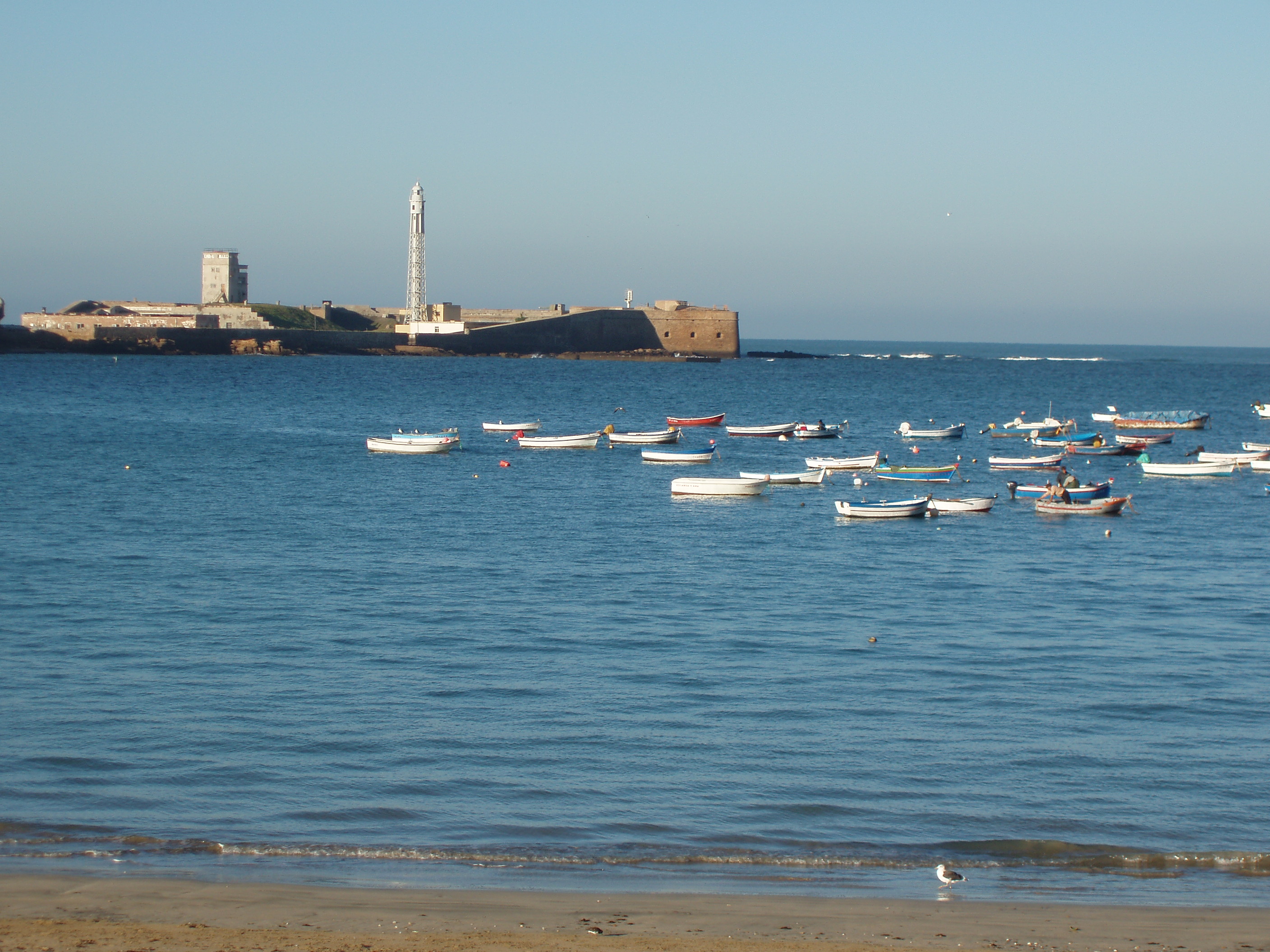
Playa de la Caleta, Cádiz, España, 2015-12-08, DD 53.JPG

Andalusia, ES

Playa de La Caleta

Cádiz is one of the oldest cities in Western Europe, and La Caleta is the seam in it: a small beach where a Phoenician channel resurfaces at low tide.

Playa de la Caleta, Cádiz, España, 2015-12-08, DD 53.JPG · <bdi><a href="https://www.wikidata.org/wiki/Q28147777" class="extiw" title="d:Q28147777"><span title="Spanish photographer">Diego Delso</span></a></bdi> · CC BY-SA 4.0
Substrate
sand
Spring tide
2.74 m
Nearest airport
ROZ · 13 km
Tier
Featured
I’m here for
Story

Playa de La Caleta is the only beach inside the walled old town of Cádiz, on the southwestern tip of Spain where the Andalusian coast turns into the Atlantic. It is small: roughly 450 meters of golden sand, about 30 meters deep, curved into a tight crescent and hemmed at both ends by stone. The Castillo de Santa Catalina, begun in 1598, holds the north headland; the Castillo de San Sebastián, reached by a long causeway, carries the city lighthouse on the south. Between them, the beach is less a destination than the seam where the old city meets the sea.

The Phoenicians of Tyre founded a trading post here, Gadir, that ancient writers dated to around 1100 BC; the oldest archaeology so far points to the ninth century BC. That makes Cádiz one of the oldest continuously inhabited cities in Western Europe, and La Caleta is its front door to the ocean. What is now the old town was once two islands, Erytheia and Kotinoussa, split by a navigable channel that ran through La Caleta, and at low tide you can still read its line in the exposed rock and sand.

Underwater, the bay is an archaeological site. Surveys have pulled Phoenician, Punic, and Roman material from the shallows off La Caleta: amphorae, incense burners, miniature vessels, metal ingots, stone anchors. Scholars still argue about it. Some read the small votive objects as offerings cast into the water; others see shipwreck debris and erosion. Either way, the beach sits on top of an archive.

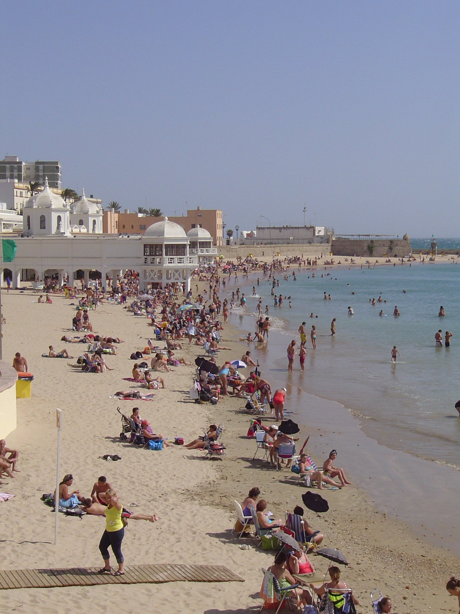
The building at the center is the Balneario de Nuestra Señora de la Palma y del Real, a white bathing pavilion on stilts over the water, inaugurated in 1926. Declared a ruin in 1975 and listed as heritage in 1990, it was restored and now houses the Centro de Arqueología Subacuática de Andalucía, the regional underwater-archaeology center: the building that was once a spa for bathers now studies what is buried beneath them.

La Caleta belongs to La Viña, the old fishermen's quarter, which treats it as an extension of the house. It is the visual heart of the Cádiz Carnival, and the flamenco peñas and fish bars sit a street or two back. In early 2002 the James Bond film Die Another Day used La Caleta to stand in for Havana, because Cuba was closed to the filmmakers; Halle Berry, as Jinx, walked out of the water in an orange bikini in a deliberate restaging of Ursula Andress in Dr. No, except that the water was the cold Atlantic and she was wrapped in towels between takes.

It is a layered, complicated little beach, not a wide stretch of clean sand for a long day in the sun. The honest version is below.

The spike

Cádiz is one of the oldest cities in Western Europe, and La Caleta is the seam in it: a small beach where a Phoenician channel resurfaces at low tide.

Most legendary beaches earn their fame from scale or color: a long white arc, an impossible turquoise, a cliff that drops straight into the sea. La Caleta has none of that. It is about 450 meters long and roughly 30 meters deep, which is to say it is small, and at low tide a good part of what you walk on is not sand at all but exposed rock and channel bed. What makes it singular is not the beach. It is what the beach is sitting on, and what it has been sitting on for nearly three thousand years.

Cádiz is one of the oldest continuously inhabited cities in Western Europe. The Phoenicians of Tyre founded a colony here that they called Gadir, a name that meant fortress or walled place. Classical writers put the founding around 1100 BC; the hard archaeology so far reaches back to the ninth century BC. Either date makes this older than Rome. And the city did not begin as the compact peninsula it is now. At the time of the Phoenician settlement, the old town was two separate islands, Erytheia to the north and Kotinoussa to the south, divided by a navigable channel that ships could pass through. That channel ran across what is now La Caleta. The Castillo de Santa Catalina, on the north headland, stands on the old Erytheia; the Castillo de San Sebastián, out on its causeway to the south, stands on the old Kotinoussa. The beach between them is the drowned waterway that once separated them. At low tide, when the Atlantic pulls back across a tidal range that runs to roughly 2.7 meters on the spring tides, you can read the line of that ancient channel in the rock the receding water leaves behind. The beach is, quite literally, a geographic fossil of the city's first shape.

That is the first layer. The second is underwater and it is genuinely strange. The shallows off La Caleta are one of the richest underwater archaeological zones in the region. Surveys and divers have recovered Phoenician, Punic, and Roman material from this seabed across the long span from the eighth century BC to late Roman times: amphorae by the score, incense burners, miniature vessels, terracotta figures, lead and copper ingots, stone anchor stocks. The metal ingots and anchors are the unambiguous part; they confirm that this was a working channel and anchorage in Phoenician and Roman times, exactly where the ancient geography says it should be. The smaller objects are where it gets interesting and unresolved. A cluster of miniature amphorae and incense burners has driven a real scholarly argument: one camp reads them as votive offerings, deliberately cast into the water as part of the maritime cult of a seafaring people who worshipped the ocean they depended on; another camp argues they are simply the accumulated debris of shipwrecks and centuries of erosion washing material off the shore. The dispute is not settled, and an honest page has to say so rather than pick the prettier story. What is not in dispute is the quantity, and that is the point: you are swimming over an archive.

The third layer is the one most visitors actually see, and it is the one that ties the beach to the modern imagination. The Balneario de Nuestra Señora de la Palma y del Real, the white pavilion that sits on legs out over the water at the center of the crescent, was inaugurated in 1926 as a bathing establishment, one of the most recognizable buildings raised in Cádiz in the early twentieth century. It fell into ruin, was declared so in 1975, was listed as heritage in 1990, restored, and now houses the Centro de Arqueología Subacuática de Andalucía, the body responsible for the very underwater heritage the bay holds. A spa became the office that studies what is buried under the bathers. Few beaches close their own loop that neatly.

And then there is the screen. In early 2002 the James Bond production Die Another Day needed Havana, and Cuba was off limits, so it used Cádiz, and La Caleta specifically, to double for the Cuban capital. The scene shot here is one of the most quoted in the franchise: Halle Berry's character, Jinx, rising out of the surf in an orange bikini, a shot staged as a direct homage to Ursula Andress emerging from the sea in Dr. No forty years earlier. The detail that matters for honesty is that it was filmed in the cold Atlantic in winter, not the warm Caribbean it pretended to be, and accounts describe Berry wrapped in towels between takes. The beach has been pretending to be somewhere else, on camera, ever since people decided it was worth pointing a camera at.

So the case for La Caleta is not that it is the best beach in Andalusia to spend a day on. It is not. It is that no other beach this small carries this much. A Phoenician channel underfoot, one of Europe's oldest cities at your back, a museum of the seabed standing on stilts over the water, a Bond scene shot in the surf, and a Carnival neighborhood that treats the sand as a public living room. La Caleta is what happens when three thousand years of a city all drain to the same fifty meters of shore.

Playa de la Caleta en Cádiz - panoramio.jpg
Culture

Where it shows up

Film
  • Die Another Day · 2002
    Lee Tamahori (director)

    The twentieth James Bond film used La Caleta to double for Havana, Cuba, in early 2002. The scene of Jinx (Halle Berry) emerging from the sea in an orange bikini, a restaging of Ursula Andress in Dr. No, was filmed here in the cold Atlantic; the castles of the beach doubled for a Cuban clinic.

  • Dr. No · 1962
    Terence Young (director)

    The original Bond film, whose image of Ursula Andress rising from the sea in a white bikini is the scene that Die Another Day deliberately recreated at La Caleta forty years later with Halle Berry, linking the Cádiz beach to one of cinema's most copied shots.

History
  • The Phoenician channel of Gadir

    The navigable channel that divided the two ancient islands of Erytheia and Kotinoussa ran through what is now La Caleta. The submerged Phoenician, Punic, and Roman finds in the bay, from amphorae to ingots and anchors, make the beach a working part of the story of Gadir, one of Western Europe's oldest cities.

Other
  • Carnival of Cádiz at La Caleta

    La Caleta is the symbolic heart of the Carnival of Cádiz, declared a Festival of International Tourist Interest. Its neighborhood, La Viña, centered on Calle de la Palma, is the epicenter of the festival, and processions and fireworks are staged at the beach during Carnival.

Cadiz playa caleta.jpg
History

What happened here

  1. -1100historic

    Phoenicians found Gadir

    Ancient writers date the Phoenician founding of Gadir, the colony from Tyre that became Cádiz, to around 1100 BC, making it one of the oldest cities in Western Europe; the earliest hard archaeology so far reaches the ninth century BC. The settlement occupied two islands, Erytheia and Kotinoussa, divided by a channel that ran through what is now La Caleta.

    Wikipedia →
  2. -500historic

    La Caleta at its commercial peak

    By around the fifth century BC the bay and its channel functioned as a Punic anchorage and trade hub, exporting salted fish and handling goods; underwater finds of amphorae, ingots, and anchors off La Caleta document the maritime activity of this period.

  3. 1598historic

    Castillo de Santa Catalina begun

    Construction of the star-shaped Castillo de Santa Catalina on the northern headland of La Caleta began in 1598, two years after an Anglo-Dutch force sacked Cádiz in 1596 and the engineer Cristóbal de Rojas was sent to fortify the city. It was completed in 1621.

  4. 1706historic

    Castillo de San Sebastián built

    The Castillo de San Sebastián was built in 1706 on the rocky islet at the southern end of La Caleta, on the site of older fortifications, reached from the beach by a long causeway. It later carried the city lighthouse.

  5. 1913infrastructure

    San Sebastián lighthouse electrified

    The metal lighthouse structure on the Castillo de San Sebastián, of a design described as unique in Spain, was completed in 1910 and entered service with electric light in 1913, marking the southern point of the La Caleta crescent.

  6. 1926construction

    Balneario de la Palma inaugurated

    The Balneario de Nuestra Señora de la Palma y del Real, the white bathing pavilion built out over the water at the center of La Caleta, was inaugurated in 1926 and became one of the most recognizable Cádiz buildings of the early twentieth century.

  7. 1990policy

    Balneario listed as heritage and restored

    After being declared a ruin in 1975, the Balneario was listed as cultural heritage by the regional government of Andalusia in 1990 and restored; it now houses the Centro de Arqueología Subacuática de Andalucía, the regional underwater-archaeology center.

  8. 2002cultural

    Die Another Day films La Caleta as Havana

    In early 2002 the James Bond film Die Another Day used La Caleta to stand in for Havana, Cuba, which was closed to the production. The scene in which Halle Berry's character Jinx emerges from the sea in an orange bikini, a homage to Ursula Andress in Dr. No, was shot in the cold Atlantic here rather than the Caribbean.

    Wikipedia →
  9. 2019natural

    BioCaleta biodiversity survey

    The BioCaleta research project documented the living community of La Caleta, identifying 294 animal species and 88 species of flora (algae) in and around the bay, a record of how much life the shallow, sheltered harbor holds.

The honest part
Come for a monument that happens to have a beach, not a beach that happens to have monuments.

La Caleta is a small, shallow, urban beach, and treating it as a long sun-and-swim destination will disappoint you. It is about 450 meters long and only some 30 meters deep, so on a hot summer day or during Carnival it packs to capacity and the sand runs out fast. The tidal range matters here in a way it does not at a steep ocean beach: with spring tides reaching roughly 2.7 meters, low water exposes wide flats of rock, channel bed, and shallow pools, and the swimmable water retreats a long way out. The bay is enclosed and sheltered, which makes it calm and family-friendly but also means the water moves slowly; it sits in the middle of a working city of well over a hundred thousand people, not on an open wild coast. The official EU bathing-water rating for the site is excellent, but it is still an enclosed urban harbor, and the gentle, glassy water that makes it good for children is the same stillness that gives it less flushing than the open Atlantic beaches a short walk south.

None of that is a reason to skip it. It is a reason to come for what it actually is. La Caleta is a place to walk into history, watch the sun set between two castles, eat fried fish a street back in La Viña, and stand over a buried Phoenician channel. It is not where you go to claim ten meters of empty sand for the afternoon. Time it for the rising tide, come outside the August crush, and judge it as a monument that happens to have a beach, not a beach that happens to have monuments.

Alatriste La Caleta.jpg
Anatomy

The shape of the place

Santa Catalina end

12%

The northern headland under the star-shaped Castillo de Santa Catalina, begun in 1598 on the old island of Erytheia. Rockier ground, the quieter end of the beach.

Best for History and a calmer corner

Check castle opening hours; it hosts exhibitions and events.

The Balneario center

50%

The middle of the crescent, dominated by the white 1926 Balneario de la Palma pavilion on its legs over the water, now the regional underwater-archaeology center. The busiest, most photographed stretch of sand.

Best for The defining photograph and people-watching

Fills first and stays full in summer and at Carnival.

The low-tide flats

50%

The rock and channel bed exposed across the center of the bay at low spring tide, tracing the line of the ancient navigable channel that once divided the two islands. Pools, weed, and uneven rock rather than sand.

Best for Reading the old geography; tide pools

This is the part that vanishes under water as the tide rises; footwear helps.

San Sebastián causeway

88%

The southern point, where a long stone causeway runs out to the Castillo de San Sebastián and its lighthouse. The walk is exposed and the sea closes over parts of the approach at high tide.

Best for The sunset walk and the lighthouse view

Mind the tide on the causeway; the rocks are slick.

Landmarks

Balneario de Nuestra Señora de la Palma y del Real · 1926

building

The white bathing pavilion built on legs over the water at the center of La Caleta, inaugurated in 1926 and one of the most recognizable Cádiz buildings of the early twentieth century. Declared a ruin in 1975, listed as heritage in 1990 and restored, it now houses the Centro de Arqueología Subacuática de Andalucía.

Wikipedia →

Castillo de San Sebastián · 1706

fortification

The fortress on a rocky islet at the southern end of La Caleta, built in 1706 on the site of older defenses and reached by a long stone causeway from the beach. It carries the city lighthouse, whose metal tower entered electric service in 1913.

Wikipedia →

Castillo de Santa Catalina · 1598

fortification · Cristóbal de Rojas (engineer)

The star-shaped fortress on the northern headland of La Caleta, begun in 1598 after the 1596 Anglo-Dutch sack of Cádiz and completed in 1621. It later served as a military prison and now hosts cultural events and exhibitions.

Wikipedia →
A day here

From first light to dark

Dawn

Before the cafes open, the crescent belongs to the gulls and the turnstones working the tideline, and to whoever timed the low water to walk out across the exposed rock toward the San Sebastián causeway. The Balneario's white arches catch the first flat light off the Atlantic while the sand is still cool and almost empty.

Midday

By late morning the small beach is full, especially in summer, and the 30-meter depth of sand fills shoulder to shoulder between the Balneario and the seawall. The enclosed bay is calm and shallow, good for children, and at midday on a low spring tide the water has pulled far out across rock and pools.

Golden hour

Late afternoon is what La Caleta is famous for: the sun drops between the two castles and into the open Atlantic, and the whole crescent turns gold. The seawall and the causeway fill with people who have come for the sunset rather than the swim, and the light is the reason to be here.

Night

After dark the beach itself empties and the life moves one street inland to La Viña, where the fish bars and flamenco peñas run late. During Carnival the order reverses and the sand fills again, with processions, carts, and fireworks staged over the water at La Caleta.

Compare

How it ranks

Peak warmth
Cooler than 58% of beaches in its country
Peak-month high ≈ 27°C

Ranked against every beach in our database — 228,000+ worldwide.

Castillo de San Sebastián Cádiz 1.jpg
Sea & surf

What the water does

JFMAMJJASONDmetres (significant wave height)

Solid = typical monthly wave height; pale = the bigger days (90th pct). Offshore/regional swell from Open-Meteo Marine (ERA5 Ocean reanalysis, 2023–2024); a sheltered cove may sit calmer than this.

Mixed — usually swimmable, with a livelier season
Typical wave height
1.05 m
Biggest swell
Mar · 1.65 m
Calmest
Jul · 0.68 m
Typical period
8.4 s (groundswell)
Before you go

Things to know

Time the tide

Spring tides here run to roughly 2.7 meters. At low water the center of the bay turns to exposed rock, pools, and channel bed and the swimmable sea retreats far out. Come on a rising or high tide for the most water and the most sand.

It is small and it fills

The beach is about 450 meters long and only some 30 meters deep. In summer and at Carnival it packs to capacity early; arrive in the morning or accept the crowd.

Enclosed, sheltered water

The bay is calm and shallow, which makes it good for children and weak swimmers, but it is an enclosed urban harbor with slow flushing rather than open Atlantic surf. The official EU bathing rating for the site is excellent.

Mind the causeway

The stone causeway out to the Castillo de San Sebastián is exposed and the sea covers parts of the approach at high tide; the rocks are slippery. Check the tide and the castle's hours before walking out.

Sharks

No incidents on record in the global shark-attack file.

Plan

If you go

Getting there
Nearest airport
Rota Naval Station Airport (ROZ) · 13 km
Nearest town
Cadiz · 1 km

La Caleta is inside the old town of Cádiz, about a kilometer from the city center and easily reached on foot through the historic streets; the nearest neighborhood is La Viña. Cádiz is the end of the line on the Renfe rail and Cercanías network from Seville and Jerez, and the train station is a walkable distance or a short taxi from the beach. There is no dedicated beach parking and the old town is tight for cars; arrive on foot, by local bus, or by train. The nearest commercial airports are Jerez (about 40 km) and Seville (about 120 km); Rota Naval Station lies across the bay but is a military airfield.

When to go
  • Carnival of Cádiz · February (dates shift each year; 2026 runs 12–22 February)

    One of Spain's most famous carnivals, built on satirical sung groups (chirigotas and comparsas) and centered on the La Viña quarter behind La Caleta. The beach hosts processions, carts, and a fireworks display during the celebration.

  • Sunset gathering at the seawall · Daily, late afternoon year-round

    La Caleta's west-facing crescent makes its sunset, dropping between the two castles into the open Atlantic, a daily draw. The seawall and the San Sebastián causeway fill with people who come for the light rather than the swim.

What to eat & drink
Pescaíto frito

Cádiz's defining food: small fish and squid, floured in chickpea-and-wheat flour and flash-fried, eaten in paper cones. La Viña, the old fishermen's quarter directly behind La Caleta, is its heartland, and the fish bars there are where locals eat it, not on the sand.

Fish bars in the La Viña quarter, one or two streets back from the beach

Tortillitas de camarones

Thin, lacy fritters of tiny whole shrimp, a specific Cádiz-bay specialty fried to a crisp. They are a tapa of this exact stretch of coast, sold in the same La Viña bars that serve the fried fish.

Tapas bars in La Viña and around the old town

Erizos and sea snails in season

Cádiz keeps an old habit of eating what the bay gives up: sea urchins (erizos) and whelks appear on bar counters in winter and early spring. It is seasonal and traditional rather than a tourist dish, tied to the same shallows La Caleta sits in.

Traditional bars in central Cádiz, seasonally

Nothing reliable on the sand itself

La Caleta is an urban pocket beach, not a resort strand. There are kiosks and bars in the immediate surroundings and on the promenade, but do not count on buying a full meal on the beach; the real eating is in La Viña a short walk inland.

Promenade kiosks nearby; meals inland in La Viña

Sources & references
  1. Spanish Wikipedia: Playa de La Caleta · cited 7×
  2. The James Bond Dossier; movie-locations.com · cited 2×
  3. Andalucia.org; Barceló Experiences (Gadir site)
  4. International Journal of Nautical Archaeology (Sáez & Higueras, 2018)
  5. Barceló Experiences; Andalucia.com
  6. Barceló Experiences; Spanish Wikipedia: Playa de La Caleta
  7. Barceló Experiences; Spanish Wikipedia
  8. Andalucia.org; Barceló Experiences
  9. World Beach Tour data (EOT20 tides)
  10. EU bathing-water dataset
Colophon · Provenance

Where this page comes from

Geography, facilities
OpenStreetMap (ODbL) for geometry and facility tags within 500 m of the beach centroid. GeoNames for city/airport distances.
Climate & ocean
worldclim_v2.1_2.5m
Tides
eot20
Photography
Archival, original tone (Tier B — Wikimedia Commons). Each image licensed per its own terms; attribution visible inline.
History & culture
Every factual claim is linked to its source in the prose above. Wikipedia citations inline. Non-wiki sources named where relevant.
Editorial voice
Register: romantic. Written to pass a local's nod test; corrections welcome.
Written by Erin Rose
Last reviewed 2026-04-19
v0.9in editorial development toward v1.0