Guanacaste, CR

Playa Negra

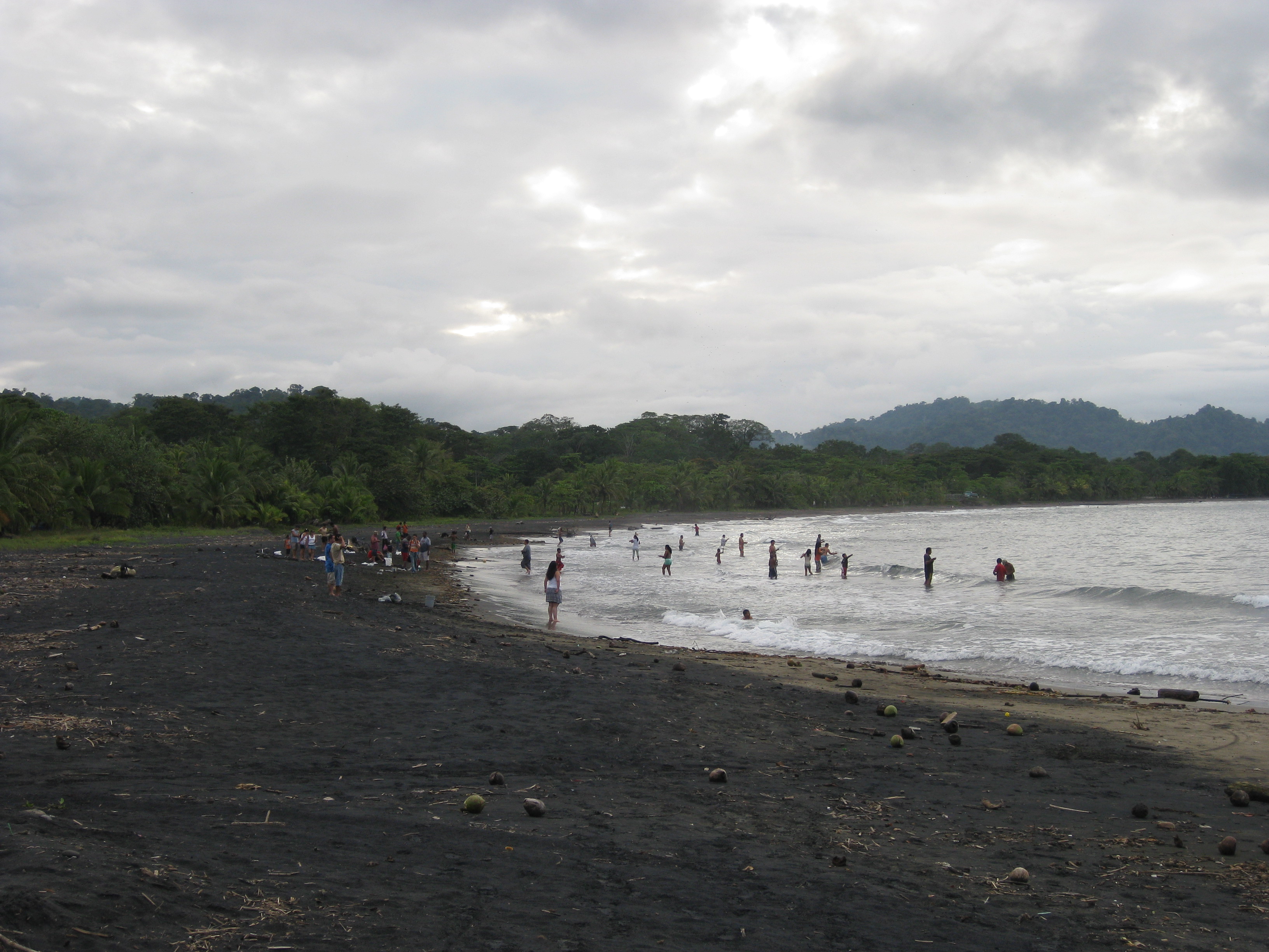
Playa Negra Costa Rica.jpg

Guanacaste, CR

Playa Negra

This reef break sits on the northern edge of the segment that ruptured in the M7.6 Nicoya quake of 5 Sept 2012; whether that reshaped the wave is unverified.

Playa Negra Costa Rica.jpg · <a href="//commons.wikimedia.org/w/index.php?title=User:Alonsosanchon&amp;action=edit&amp;redlink=1" class="new" title="User:Alonsosanchon (page does not exist)">Alonsosanchon</a> · CC BY-SA 4.0
Substrate
sand
Nearest airport
NOB · 31 km
I’m here for
Story

Playa Negra sits on the Pacific side of Costa Rica's Nicoya Peninsula, Guanacaste Province, about 27.9 km by straight line from the canton seat of Santa Cruz. The name means Black Beach, for the dark, mineral-heavy sand here. The nearest settlement is Los Pargos. Public coordinates for "Playa Negra, Costa Rica" (10°11′38″N 85°49′47″W) sit within about 140 meters of this dataset's centroid, so there is no naming mismatch to flag: this is the Guanacaste surf break, not the same-named black-sand beach near Puerto Viejo on the Caribbean side.

The wave is a right-hand reef break over a rock bottom, with a defined channel for paddling out, per the beach's own descriptive record. Reanalysis data (Open-Meteo Marine, ERA5, 2023-2024) puts annual mean wave height at 1.33 m, rising to a June average of 1.51 m and dropping to 1.12 m in March, with a typical period around 11.9 seconds. Peak recorded day: 1.92 m. The dataset's verdict: "Exposed - real surf, and rip current to respect."

Surfers reportedly rode this break from at least the 1970s, before Bruce Brown's 1994 film The Endless Summer II gave it wider recognition. Hold that credit loosely: about 12 km up the coast by straight line (roughly 25-30 km by road), Tamarindo's own history credits the same film with "launching" its own tourism boom. One film is cited as the origin story for more than one beach on this coast.

On September 5, 2012, at 8:42 a.m. local time, a magnitude-7.6 earthquake ruptured the subduction interface under the Nicoya Peninsula, centered 11 km east-southeast of Nicoya town, 40.2 km deep. It struck a segment tracked for decades as a mature seismic gap, overdue since a magnitude-7.7 rupture in 1950. Damage reached $44.8M, 169+ houses, two deaths, concentrated in Santa Cruz canton - the same canton Playa Negra sits in. The beach's own record claims the quake "lifted up the entire plate," improving the reef's wave - a claim on a page Wikipedia's editors flag as citing no sources.

Los Pargos is wired past what its road implies: culverts cross the creek beds, bridges span the rivers, and in 2010 the road got 7 meters of added rock base, alongside fiber-optic service rated to 200 Mbit/s. None of that shows on a straight-line map: the nearest airport is Tamarindo (TNO), domestic-only, about 13 km away, a single 890-meter runway frequently closed in the rainy season. A second small domestic strip, Nosara (NOB), sits farther out at 31.1 km and handled 7,350 passengers in 2014. Most travelers arrive through Liberia's international airport instead, over 50 km away, moving close to two million passengers a year.

The spike

This reef break sits on the northern edge of the segment that ruptured in the M7.6 Nicoya quake of 5 Sept 2012; whether that reshaped the wave is unverified.

Playa Negra's reputation rests on two claims almost nobody has checked. The first is that a 1994 surf film put it on the map. The second, stranger claim is that a 2012 earthquake improved the wave. Only one of those is independently documented, and it isn't the one about the wave.

A gap that had been waited on for decades. The Nicoya Peninsula sits directly above the seismogenic zone of a subduction megathrust, one of the few stretches of coastline on Earth where that zone reaches land instead of staying offshore. Seismologists had identified this segment as a mature seismic gap - a patch of fault locked and loading since its last major rupture, a magnitude-7.7 earthquake in 1950, with a recurrence interval estimated around fifty years. On September 5, 2012, at 8:42 a.m. local time, it went: a magnitude-7.6 earthquake centered about 11 kilometers east-southeast of Nicoya town, 40.2 kilometers deep. Damage came to an estimated $44.8 million, with at least 169 houses damaged and two deaths, concentrated in Santa Cruz canton and its neighbors - the same administrative canton Playa Negra falls under, about 27.9 kilometers from the beach to the canton seat by straight-line distance.

What the quake supposedly did to the reef. Playa Negra's own public description states plainly that the earthquake "lifted up the entire plate," improving the wave's form at higher tides when combined with smaller swells. It is a specific, testable claim: coseismic uplift, the permanent vertical shift in land elevation that a megathrust rupture produces, is a documented mechanism, routinely measured on subduction coastlines with GPS networks and repeat surveys. If the seafloor and reef at this exact break moved even a few centimeters in September 2012, the water depth over the reef at a given tide stage would change, and a shallower reef at high tide can plausibly sharpen a wave's shape. The mechanism is real. What's missing is any published measurement tying that mechanism to this specific reef. The page making the claim carries Wikipedia's own maintenance notice: it "does not cite any sources." Surf breaks accumulate this kind of lore constantly - the reef changed, the sandbar moved, the wave got better after the storm - and most of it never gets checked against survey data. This may be a case where the folklore happens to be geophysically plausible and still unverified.

One film, credited twice. The break's international reputation is tied to Bruce Brown's The Endless Summer II, released June 3, 1994, though surfers describe riding Playa Negra since at least the 1970s. The film's reach is genuinely well documented - but not uniquely at this beach. About 12 kilometers up the coast by straight line (roughly 25-30 kilometers by road), Tamarindo's own record describes the same film as the event "generally credited for launching a tourism boom" that turned a fishing village into Guanacaste's largest beach town, after a developer started building there in 1985. Two beaches, one film, two separate origin stories. Both are probably true in their own way: Brown's crew covered a lot of coastline, and the reputational splash landed on more than one break. It just means Playa Negra's Endless Summer II credit isn't the exclusive claim it is sometimes presented as.

A road that arrived in stages, and a fiber line that arrived anyway. For a beach whose main draw is remoteness, the infrastructure record shows deliberate, incremental investment rather than neglect: culverts added across the creek beds, bridges built over the rivers, and in 2010 specifically, seven meters of rock base added to the access road. None of that made it a highway - it remains an unpaved approach through Los Pargos - but it tracks with what actually shows up in the village now: restaurants serving Peruvian, French, and Mexican food, and a fiber-optic line rated up to 200 megabits per second. That is a bandwidth figure that beats plenty of urban connections, sitting in a village reached by a road that needed rock fill as recently as 2010.

The airport math doesn't work the way the map implies. By straight-line distance, the closest airport is Tamarindo (TNO), a domestic-only strip with a single 890-meter asphalt runway about 13 kilometers from the beach - an airstrip its own record calls frequently closed in the rainy season. It has no international service; Sansa, Aerobell, and Skyway fly its domestic routes to San José. A second small domestic strip, Nosara (NOB), sits farther out at 31.1 kilometers and handled 7,350 passengers in 2014 - a number small enough to state precisely rather than round. Most people who fly in for this beach actually land at Liberia's international airport, more than fifty kilometers away from the coast by straight line, reopened for international traffic in October 1995 and running a new 23,000-square-meter terminal since January 2012 that alone handled 1.92 million passengers in 2024. The nearest airport on a map and the airport people actually use are two different places, and the wave data measuring this exact stretch of ocean - annual mean height 1.33 meters, June the biggest month at 1.51 meters, exposed with rip current to respect - comes from a satellite reanalysis model, not a buoy anyone put in the water here.

What's actually solid. The earthquake happened, at the magnitude, date, and depth on record. The film exists and covers Costa Rica, even if its Playa Negra-specific credit rides on an uncited page. The road got rock fill in 2010. The airport passenger counts are published. What isn't solid is the one claim that gets repeated as the beach's signature fact: that the ground moving in 2012 made the wave better. Published GPS and geomorphic surveys (Protti et al., Nature Geoscience, 2014) document up to 0.8 meters of coseismic uplift along the central Nicoya coast, decaying toward the northern peninsula - but those surveys do not resolve what happened at this specific reef.

Playa Negra in 2010.jpg
Culture

Where it shows up

Film
  • The Endless Summer II · 1994
    Bruce Brown

    Surf documentary released June 3, 1994, credited by Playa Negra's own record with raising the beach's international profile - a credit shared, per Tamarindo's own record, with the tourism boom of the town about 12 km up the coast by straight line (roughly 25-30 km by road).

History
  • 2012 Nicoya Peninsula earthquake · 2012

    The M7.6 earthquake of September 5, 2012, ruptured the seismic gap this coastline sits above and is the event Playa Negra's own record credits, without citation, with reshaping the reef's wave.

Other
  • Nicoya Peninsula Blue Zone

    The wider Nicoya Peninsula is identified as one of the world's "Blue Zones" for longevity; regional context rather than a fact about the beach itself, since the designation concerns population health, not the coastline.

Dog at Playa Negra (15272765604).jpg
History

What happened here

  1. 1950natural

    The seismic gap's last rupture

    A magnitude-7.7 earthquake ruptures the same Nicoya Peninsula segment that will go again in 2012, establishing the recurrence interval seismologists later estimate at roughly 50 years.

    Wikipedia →
  2. 1970cultural

    Surfers begin riding Playa Negra

    Per the beach's own historical record, surfers were visiting and riding the right-hand reef break at Playa Negra from at least the 1970s, well before any film gave it wider recognition.

    Wikipedia →
  3. 1985cultural

    Tamarindo's tourism development begins

    A developer begins building beachside properties at Tamarindo, about 12 km up the coast from Playa Negra by straight line (roughly 25-30 km by road), starting the transformation of a fishing village into Guanacaste's largest beach town.

    Wikipedia →
  4. 1994cultural

    The Endless Summer II released

    Bruce Brown's surf documentary releases on June 3, 1994, and is later credited on Wikipedia with raising Playa Negra's profile and, separately, with launching Tamarindo's tourism boom.

    Wikipedia →
  5. 1995infrastructure

    Liberia airport reopens for international flights

    Guanacaste Airport (Daniel Oduber Quirós International Airport, LIR) is re-inaugurated as an international airport, eventually becoming the practical gateway for Playa Negra despite lying farther away than the nearest domestic airstrip.

  6. 2010infrastructure

    Rock base added to the Los Pargos access road

    Seven meters of rock base are added to the unpaved road serving Los Pargos and Playa Negra, part of a longer pattern of culverts and bridges added to the route over time.

    Wikipedia →
  7. 2012infrastructure

    New Liberia terminal opens

    A privately built 23,000-square-meter terminal opens at Liberia's international airport, expanding capacity for the Pacific-coast tourism corridor that includes Playa Negra.

  8. 2012natural

    M7.6 Nicoya earthquake

    A magnitude-7.6 earthquake ruptures the subduction interface beneath the Nicoya Peninsula on September 5 at 8:42 a.m. local time, centered 11 km east-southeast of Nicoya. Playa Negra's own record credits the quake with reshaping the reef's wave, a claim that remains uncited.

    Wikipedia →
  9. 2014economy

    Nosara Airport passenger count published

    A second small domestic airstrip in the region, farther from Playa Negra than Tamarindo by straight-line distance, handles 7,350 passengers for the year, a 10.1% increase over 2013, underscoring how minor the region's domestic airstrips are relative to the beach's actual traveler flow.

The honest part
“The most repeated fact about this reef is a claim no published survey has tested at this reef.”

The uncomfortable truth about Playa Negra is that its most repeated fact is unverifiable and its most marketed quality is manufactured. The claim that the 2012 earthquake reshaped the reef into a better wave traces to a single uncited paragraph on a page Wikipedia itself flags as citing no sources; published GPS and geomorphic uplift surveys of the earthquake exist, but none of them resolve whether this specific reef moved. And the remoteness that draws surfers here - the unpaved road, the lack of a real airport nearby - coexists with a fiber-optic line rated to 200 megabits per second and a restaurant scene serving Peruvian, French, and Mexican food to what is, by any honest description, an expatriate and digital-nomad economy. This is not an undiscovered break preserved by isolation. It is a well-connected surf economy that markets isolation while steadily building the infrastructure that undermines it - rock-filled roads, bridges, broadband - one project at a time.

The reef break itself carries real, unglamorous risk that no marketing softens: a fast, hollow wave over a rock bottom, in a stretch of coast exposed enough that the regional wave model's own one-line summary is a warning about rip current, not a sales pitch. And the beach sits inside a documented earthquake hazard zone - the same Nicoya seismic gap that ruptured at magnitude 7.6 in 2012 after a magnitude-7.7 predecessor in 1950 - a fact more relevant to anyone staying nearby than the folklore about what that earthquake supposedly did to the surf.

Iguana at Playa Negra (15894374532).jpg
Anatomy

The shape of the place

The reef break lineup

50%

The offshore take-off zone over a rock-reef bottom, with a defined channel for paddling out. A right-hand break; not a beginner zone.

Best for Experienced reef-break surfers

Depth over the reef changes with tide; the beach's own record attributes a post-2012 change in wave form to earthquake uplift, unverified.

The black-sand shore

50%

The dark, mineral-heavy sand strip that gives the beach its name, predicted as a lithic-rich (volcanic/collisional terrane) sand regime.

Best for Walking, watching the break, sunset

Sand composition is model-predicted (GloPrSM v1.0.0), not a direct field sample, at roughly 38% quartz, 7% feldspar, 55% lithic fragments.

Los Pargos village edge

55%

The small inland settlement where the surf economy actually lives: restaurants, lodging, and a fiber-optic line rated to 200 Mbit/s, reached by an unpaved, rock-filled road.

Best for Food, lodging, connectivity

Culverts and bridges were added over time; the road got seven meters of added rock base in 2010.

Landmarks

Tamarindo Airport

airport

A domestic-only airstrip with a single 890-meter asphalt runway, about 13 km from Playa Negra by straight-line distance - the nearest airport on the map, though it carries no international flights and is frequently closed in the rainy season.

Wikipedia →

Daniel Oduber Quirós International Airport (Liberia, LIR)

airport

The international airport most Playa Negra travelers actually use, reopened for international service in October 1995 and expanded with a new terminal in January 2012; farther from the beach than Tamarindo by straight-line distance.

Wikipedia →

Los Pargos

village

The closest settlement to Playa Negra, home to the area's restaurants, lodging, and infrastructure; named for pargo, snapper.

Wikipedia →
A day here

From first light to dark

Dawn

First light finds the reef break already working; Guanacaste's dry-season mornings bring the lightest wind of the day, and low-tide reef exposure at dawn is when the rock bottom is easiest to see and avoid.

Midday

By late morning the sun is direct and the black sand absorbs and radiates heat sharply enough to burn bare feet; monthly wave heights for this stretch run 1.12-1.51 meters depending on the month, with the reef's channel doing steady work ferrying surfers past the break.

Golden hour

Late-afternoon light is when the earthquake-improved-wave claim gets tested informally by every surfer paddling out on a rising tide, chasing the higher-tide form Playa Negra's own record credits to 2012's coseismic lift, verified or not.

Night

After dark there is no beach lighting and no formal night access; Los Pargos's restaurants and fiber-fed rental economy carry on inland while the reef and its black sand go fully dark and unmonitored.

The surfer and its dog waiting for waves (15707733900).jpg
Sea & surf

What the water does

JFMAMJJASONDmetres (significant wave height)

Solid = typical monthly wave height; pale = the bigger days (90th pct). Offshore/regional swell from Open-Meteo Marine (ERA5 Ocean reanalysis, 2023–2024); a sheltered cove may sit calmer than this.

Exposed — real surf, and rip current to respect
Typical wave height
1.33 m
Biggest swell
Jun · 1.51 m
Calmest
Mar · 1.12 m
Typical period
11.9 s (groundswell)
Before you go

Things to know

Road access

The final approach to Los Pargos and Playa Negra is unpaved. Culverts and bridges have been added over time and the road got seven meters of added rock base in 2010, but it remains dirt and rock, not pavement; conditions worsen in the May-October wet season.

Expert-only reef

The break is a fast, right-hand wave over a rock-reef bottom with a defined paddle-out channel. This is not a learner wave; reef contact is a real risk for anyone who falls in the impact zone.

The nearest airport isn't the useful one

Tamarindo (TNO), about 13 km away by straight line, is domestic-only with a single 890-meter runway that's frequently closed in the rainy season. Most travelers actually arrive via Liberia's international airport, more than 50 km away by straight line.

Zero recorded shark incidents

The dataset shows zero recorded shark incidents at this beach; the more relevant hazards are the reef itself and rip current, per the regional wave model's own "real surf, and rip current to respect" summary.

Surf & rip

Powerful water — strongest around Jun, gentlest in Mar. Mind rip currents; this isn't a wade-in-anywhere beach.

Sharks

No incidents on record in the global shark-attack file.

Plan

If you go

Getting there
Nearest airport
Nosara Airport (NOB) · 31 km
Nearest town
Santa Cruz · 28 km

Playa Negra is reached via Guanacaste's coastal road network through Los Pargos, south of Tamarindo and north of Junquillal in Santa Cruz canton. The final approach is unpaved: culverts were added across creek beds, bridges built over rivers, and seven meters of rock base added to the road in 2010, but it remains a dirt-and-rock route rather than pavement. Most air travelers arrive via Liberia's Daniel Oduber Quirós International Airport (LIR), more than 50 km away by straight-line distance and reached by paved highway through Santa Cruz canton's coastal districts. A small domestic-only airstrip at Tamarindo (TNO) is closer by straight-line distance (about 13 km) but carries no international service and is frequently closed in the rainy season.

When to go
  • Wet-season swell window · May through October

    Not a festival but the closest thing to a recurring event: the wet season carries the biggest average swell for this stretch of coast, peaking in June at 1.51 m, per reanalysis wave data - the dry season (November-April) runs calmer, bottoming out at 1.12 m in March, but brings easier, less rutted road access into Los Pargos.

What to eat & drink
Casado

Costa Rica's standard lunch plate: rice, beans, salad, plantain, and a protein, served at informal sodas (small local eateries) rather than anywhere on the sand itself.

Sodas in Los Pargos village, inland from the beach

Ceviche

Citrus-cured raw fish, typically snapper or corvina, served cold - a fitting regional dish given that Los Pargos translates to "the snappers."

Restaurants in Los Pargos village

Peruvian menu at Cafe Playa Negra

A Peruvian-food restaurant named in Los Pargos, reflecting the international resident population settled around the break; this listing comes from the beach's own public record, which carries no independent citations.

Los Pargos village

French menu at Villa Deevena

A French-menu restaurant in Los Pargos, again per the beach's public record and subject to the same sourcing caveat; the beach itself has no on-sand food service.

Los Pargos village

Sources & references
  1. Wikipedia: 2012 Costa Rica earthquake · cited 4×
  2. Wikipedia: Playa Negra, Costa Rica · cited 4×
  3. Wikipedia: Daniel Oduber Quirós International Airport · cited 3×
  4. Wikipedia: Tamarindo, Costa Rica
  5. Wikipedia: The Endless Summer II
  6. Wikipedia: Nosara Airport
  7. Wikipedia: Tamarindo Airport (straight-line distance calculated from its published coordinates)
  8. beach dataset (nearest_airport.distance_km); Wikipedia: Nosara Airport (passenger data)
  9. Open-Meteo Marine ERA5, 2023-2024
Colophon · Provenance

Where this page comes from

Geography, facilities
OpenStreetMap (ODbL) for geometry and facility tags within 500 m of the beach centroid. GeoNames for city/airport distances.
Climate & ocean
Open-Meteo ERA5 + Marine archive, 2014–2023 monthly normals.
Photography
Archival, original tone (Tier B — Wikimedia Commons). Each image licensed per its own terms; attribution visible inline.
History & culture
Every factual claim is linked to its source in the prose above. Wikipedia citations inline. Non-wiki sources named where relevant.
Editorial voice
Register: wry. Written to pass a local's nod test; corrections welcome.
Written by Erin Rose
Last reviewed 2026-04-19
v0.9 — in editorial development toward v1.0