CW

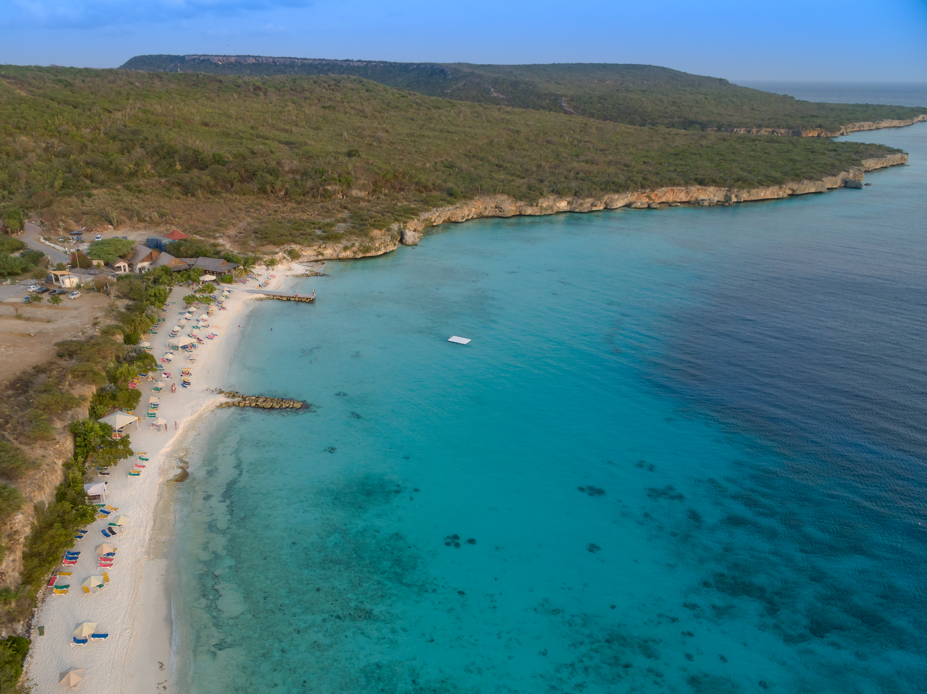
Playa Porto Marie

Playa-Porto-Marie.jpg

CW

Playa Porto Marie

On 19 August 1795, rebels led by Tula broke a 67-man Dutch militia column near this bay, the revolt's sharpest tactical defeat for the colonial government.

Playa-Porto-Marie.jpg · Martijn Meijerink; SkitterPhoto · CC0
Nearest airport
CUR · 14 km
I’m here for
Story

Playa Porto Marie is a private, fee-gated beach on a plantation bay in Curaçao's Bandabou district, near Sint Willibrordus, 25 km by road from Willemstad and 19 km by road (23 min) from Hato International Airport (CUR) — versus the dataset's 14.2 km straight-line figure. Entry costs Nafl. 5.00 (about $3), plus $3.50 for a chair. The name isn't decorative: this was an 18th-century plantation, and one night in August 1795 it was a battlefield.

Dutch authorities permitted cattle farming here in 1684; by 1704 a 593-hectare plantation ran between Rif St. Marie and Lelienberg, producing milk, buttermilk, and cheese for daily delivery to Willemstad. About seventy dwellings housed enslaved and free laborers; stable ruins survive. In 1738 the Dutch West India Company built a coral-stone storehouse on Seru Basora hill, capped by a belpaal watchtower (restored 2014); the bay was fortified in stone as Fort Porto Marie in 1742.

On 17 August 1795, an enslaved worker named Tula walked off Knip plantation with 40–50 followers, launching Curaçao's largest slave revolt; the column swelled to roughly 2,000 as it crossed the island. On 19 August, Father Jacobus Schinck tried and failed to negotiate Tula's surrender at Porto Marie. That same day a 67-man Dutch militia under Lieutenant R.G. Plegher sailed from Willemstad to attack the rebel camp there — and was defeated and driven off, the government's sharpest tactical defeat of the revolt. Tula was betrayed and captured on 19 September, then tortured to death at Rif, Otrabanda, on 3 October 1795.

The fort didn't outlast the century: English forces attacked, plundered, and destroyed it in 1805. The plantation changed hands afterward; Dr. Nicolaas Rojer ran the estate from 1874 until his death in 1885; an 1867 letter records it in financial trouble.

None of that is signposted at the gate. What greets visitors is a private beach club: a TripAdvisor-ranked restaurant, rental chairs, a viewing tower, and a shore-accessible dive site called the Valley — two reef walls at roughly 15 and 18 meters split by a sand channel, visibility often past 30 meters. Hundreds of artificial reef blocks have since been sunk to rebuild coral cover. Curaçao law nominally guarantees public beach access; fee-gated private beaches like this remain a live political argument about who controls the shoreline.

The spike

On 19 August 1795, rebels led by Tula broke a 67-man Dutch militia column near this bay, the revolt's sharpest tactical defeat for the colonial government.

What actually happened on 19 August 1795. On the evening of 19 August, Franciscan priest Jacobus Schinck went to Porto Marie plantation, on Curaçao's southwest coast, to talk Tula out of the rebellion he had launched two days earlier. Schinck met Tula at 8:30 p.m. and heard him invoke France's occupation of the Netherlands and the abolition already underway in French colonies as grounds for freedom. The negotiation went nowhere. Colonial authorities weren't only talking. The same day, a militia force of 67 men under Lieutenant R. G. Plegher left Willemstad by boat, landed near Boca San Michiel, and marched on the rebel encampment at Porto Marie to break the revolt by force before it could spread further.

Why it failed. The rebels beat them decisively, though the sources don't agree on exactly where. The English-language Wikipedia account of the revolt places Plegher's defeat at Porto Mari itself. Dutch-language accounts (Curaçaose slavenopstand van 1795) place his actual defeat at the neighboring Oud St. Marie plantation, where the rebels captured roughly eighty rifles, before his column ever reached Porto Mari. Set against the eventual outcome — Tula's capture and execution six weeks later — the Porto Marie engagement can read like a footnote. At the time it was the opposite: it was the government's most direct attempt to crush the revolt militarily in its first week, and it failed completely. For a brief window in August 1795, the colonial government of Curaçao did not control a plantation twenty-five kilometers from its own capital, and had just lost a pitched fight to people it had legally classified as property.

The scale of what Tula built. Tula left Knip plantation on 17 August with forty to fifty people. By the time colonial authorities were negotiating with him at Porto Marie two days later, the movement numbered in the hundreds, and it eventually swelled to roughly two thousand people, freeing enslaved workers and prisoners at plantation after plantation as it crossed the island: Lagún, Santa Cruz, San Nicolas, Santa Martha, San Juan, Porto Marie among them. Two thousand people is not a skirmish. On an island whose entire enslaved population numbered in the low tens of thousands, it was a substantial fraction of the colony rising at once, coordinated well enough to defeat a professional militia force in open engagement.

What the site chose to remember, and what it didn't. Porto Marie was already a working plantation before the revolt reached it, one with a decades-old fort (rebuilt in stone in 1742) and, from 1738, a Dutch West India Company storehouse on the hill above the bay. Its strategic value — a defensible bay, a fort, a garrison-worthy plantation house — is exactly what made it a target for the government's counterattack, and exactly what made it, briefly, ground the rebels could hold. None of that is why the beach is known today. The dive shop's marketing calls the reef system "the Valley" and sells snorkeling trips over the coral blocks sunk to rebuild what tourism and runoff degraded. The 1795 battle isn't part of the pitch.

The fort didn't survive either. Ten years after the rebels routed the Dutch militia, English forces attacked Porto Marie in 1805 and destroyed the fort outright — the same coastline that had beaten off a colonial militia proved unable to hold against a foreign navy. The plantation persisted as an agricultural concern into the nineteenth century, though under diminishing returns. By the time Dr. Nicolaas Rojer took over the estate in 1874, it was already a marginal operation; an 1867 letter from a neighboring plantation owner documents Porto Marie in financial trouble years before that, as Curaçao's economy shifted away from plantation agriculture altogether and toward the trade and, later, oil-refining economy that would come to dominate the island in the twentieth century.

The through-line to the fee at the gate. A private operator now charges Nafl. 5.00, about three dollars, for entry to the same bay, an arrangement that sits in a genuine legal gray zone: Curaçao law states that beaches must remain accessible to the public, and lawmakers have called for more transparency around exactly the kind of contract that lets Porto Marie, Mambo Beach, and Cas Abao charge admission at all. The mechanism is different — no militia is involved — but the underlying question is the same one the plantation's owners and the rebels who broke through their defenses in 1795 were fighting over: who gets to stand on this stretch of coast, and on what terms. The reef balls and the viewing tower answer that question with a price list, payable at a booth instead of a fort wall. The historical record shows it has never been a settled one at Porto Marie, only re-negotiated, generation after generation, by whoever currently controls the gate.

Playa Porto Marie 3.jpg
Culture

Where it shows up

History
  • Battle of Porto Marie / Curaçao Slave Revolt of 1795 · 1795

    The 19 August 1795 defeat of a 67-man Dutch militia by Tula's rebels at Porto Marie, the sharpest tactical loss the colonial government suffered during the largest slave revolt in Curaçao's history.

  • Tula, national hero of Curaçao

    Tula, who led the 1795 revolt and was tortured to death on 3 October 1795, has been officially recognized as a national hero of Curaçao since 2010; Museo Tula at Knip plantation memorializes him.

  • Belpaal restoration, Seru Basora · 2014
    François van der Hoeven / NAAM foundation

    A 2014 restoration of the near-collapsed 18th-century belpaal watchtower above Porto Marie bay, led by the archaeology working group of the NAAM foundation.

Other
  • El Indjan rock formation

    A distinctive rock formation known locally as El Indjan ("The Indian") near Sint Willibrordus, part of the salt-pan and plantation landscape surrounding Porto Marie bay.

Playa Porto Mari beach (34089797754).jpg
History

What happened here

  1. 1684founding

    Cattle farming permitted at Porto Marie bay

    Dutch colonial authorities grant permission for livestock farming at the strategically located Porto Marie bay, the earliest documented step toward the plantation that would later occupy the site.

    Wikipedia →
  2. 1704founding

    593-hectare plantation established

    Porto Marie is formally established as a 593-hectare plantation between Rif St. Marie and Lelienberg, becoming known for milk, buttermilk, and cheese production delivered daily to Willemstad.

  3. 1738construction

    West India Company storehouse built on Seru Basora

    The Dutch West India Company builds a coral-stone storehouse with an attached threshing floor on Seru Basora, the hill above Porto Marie bay, topped by a belpaal watch-and-signal tower.

  4. 1742military

    Fort Porto Marie rebuilt in stone

    The Dutch rebuild the fortification guarding Porto Marie bay in stone, naming it Fort Porto Marie, reflecting the bay's strategic value on Curaçao's west coast.

    Wikipedia →
  5. 1795conflict

    Battle of Porto Marie

    On 19 August, a 67-man Dutch militia under Lieutenant R. G. Plegher sails from Willemstad to crush Tula's rebel camp at Porto Marie and is defeated and driven off; Dutch-language accounts place the actual defeat at the neighboring Oud St. Marie plantation, where the rebels captured roughly eighty rifles. The same evening, Father Jacobus Schinck fails to negotiate Tula's surrender at the plantation.

    Wikipedia →
  6. 1795conflict

    Tula tortured to death

    Betrayed and captured on 19 September, Tula, leader of the revolt that fought its sharpest battle at Porto Marie, is publicly tortured to death at Rif, Otrabanda, on 3 October.

    Wikipedia →
  7. 1805military

    English forces destroy Fort Porto Marie

    English forces attack, plunder, and destroy Fort Porto Marie, ending the site's century-plus run as a fortified position on Curaçao's west coast.

    Wikipedia →
  8. 1874ownership

    Dr. Nicolaas Rojer settles at Porto Marie

    Dr. Nicolaas Rojer acquires and settles at the Porto Marie estate, running it until his death in 1885, by which point the plantation economy on Curaçao was already in long-term decline.

  9. 2014preservation

    Belpaal on Seru Basora restored

    The NAAM foundation's archaeology working group, led by François van der Hoeven, restores the badly deteriorated 1738 belpaal watchtower on Seru Basora above Porto Marie bay.

The honest part
“The dive shop sells trips to "the Valley." Nothing at the gate mentions the militia that was routed here in 1795.”

Porto Marie's honest problem is erasure by omission, not falsification. Nothing on the beach's website or at the gate is factually wrong; nothing mentions that on 19 August 1795 this bay was the site of the sharpest tactical defeat the colonial government suffered during the largest slave revolt in Curaçao's history, or that the plantation whose ruins still stand on Seru Basora ran on the labor of roughly seventy enslaved and free residents. The dive shop sells trips to "the Valley." The restaurant is ranked #8 of 211 on TripAdvisor. Both are true, and both are silent about what happened on the ground they're built on.

That silence has a modern echo. Curaçao law says the island's beaches must remain accessible to the public, yet Porto Marie, like Mambo Beach and Cas Abao, charges admission — Nafl. 5.00 here, plus $3.50 for a chair — under contracts between the government and private operators that lawmakers themselves have called for more transparency about. The 1795 rebels fought their way onto this land because the plantation's owners had fenced it. Nobody needs force to keep people out now; a turnstile and a fee do a version of the job the fort was built for.

Playa Porto Marie 2.jpg
Anatomy

The shape of the place

The Valley dive site

40%

A shore-accessible double-reef system with a sandy channel between two coral walls at roughly 15 and 18 meters; visibility often exceeds 30 meters.

Best for Diving and snorkeling

Position approximate; described in dive-guide sources as offshore from the main beach.

Main beach and restaurant terrace

50%

The fee-gated public-facing strip: rental chairs, a viewing tower, and the on-site restaurant, open 9:30 a.m.–6:30 p.m. daily.

Best for Swimming, sunbathing, casual dining

Entry Nafl. 5.00 (~$3); chairs $3.50 more.

Former Fort Porto Marie site

55%

The bay-mouth position the Dutch fortified in stone in 1742 and lost to English forces in 1805; no structure remains standing today.

Coordinates approximate; the fort itself no longer stands and its footprint isn't marked on-site.

Seru Basora (storehouse and belpaal ruins)

60%

The hill above the bay carrying the 1738 Dutch West India Company coral-stone storehouse ruins and the belpaal watchtower, restored in 2014.

Best for History, photography

Coordinates approximate; exact ruin footprint not published in available sources.

Landmarks

Fort Porto Marie (site) · 1742

fortification

A Dutch fortification guarding Porto Marie bay, rebuilt in stone in 1742 and destroyed by English forces in 1805. No structure survives today.

Wikipedia →

West India Company storehouse and belpaal, Seru Basora · 1738

plantation structure · Dutch West India Company (WIC)

A coral-stone storehouse with attached threshing floor, topped by a belpaal watch-and-signal tower, built on the hill above Porto Marie bay; restored in 2014 after near-collapse.

Sint Willibrordus Church · 1888

church · Evert Margry

Neo-Gothic Roman Catholic church in the village of Sint Willibrordus, built 1884-1888 and the namesake landmark of the settlement nearest Porto Marie bay.

Wikipedia →
A day here

From first light to dark

Dawn

Before the 9:30 a.m. gate opens, Porto Marie bay is empty water and coral-stone ruins on Seru Basora catching first light — the closest the site gets to how it looked before the beach club and the fee booth.

Midday

By midday the private beach fills with rental-chair rows and swimmers over the Valley dive site, visibility often past 30 meters; the on-site restaurant runs first-come tables with no reservations.

Golden hour

Late afternoon light picks out the coral-stone storehouse and restored belpaal on Seru Basora, the same rise the 1738 West India Company watchtower used to survey the water the militia sailed into in 1795.

Night

The beach closes at 6:30 p.m. daily, and stays shut entirely on 31 December and Carnival Sunday; after dark the bay reverts to the dark, unlit plantation coastline it was for most of its history.

Playa Porto Mari Strand (34933052135).jpg
Sea & surf

What the water does

JFMAMJJASONDmetres (significant wave height)

Solid = typical monthly wave height; pale = the bigger days (90th pct). Offshore/regional swell from Open-Meteo Marine (ERA5 Ocean reanalysis, 2023–2024); a sheltered cove may sit calmer than this.

Mixed — usually swimmable, with a livelier season
Typical wave height
1.12 m
Biggest swell
Jul · 1.25 m
Calmest
Oct · 0.91 m
Typical period
5.9 s (wind chop)
Before you go

Things to know

Entry costs money

Nafl. 5.00 (about $3) per person; children under 4 free; beach chairs $3.50. Open daily 9:30 a.m.–6:30 p.m., closed 31 December and Carnival Sunday.

Bring cash

Guilders (Nafl.) or dollars are standard at the gate; card acceptance isn't guaranteed at small beach operations on this coast.

It's a dive/snorkel beach, not a party beach

The draw is the shore-accessible double-reef Valley dive site (visibility often past 30 m); there's no nightlife or late hours.

No historical marker on-site

Nothing at the entrance notes the 19 August 1795 battle or the plantation's slave-labor history; that record exists in archival and academic sources, not signage.

Sharks

No incidents on record in the global shark-attack file.

Plan

If you go

Getting there
Nearest airport
Hato International Airport (CUR) · 14 km
Nearest town
Dorp Soto · 6 km

Porto Marie sits on Curaçao's southwest coast in the Bandabou district, near Sint Willibrordus. By road it's roughly 25 km (about 30-45 minutes depending on traffic) from central Willemstad, and about 19 km / 23 minutes' drive from Hato International Airport (CUR) — notably more than the 14.2 km straight-line distance in the underlying dataset, since the coast road curves around Bullen Bay and Daaibooi. There's no public transit to the gate; a rental car or taxi is standard, with Sint Willibrordus village, about 2 miles inland, the nearest public-transport stop.

When to go
  • Dia di Lucha pa Libertat (Tula Day) · Annually, 17 August

    Curaçao's island-wide commemoration of the 1795 revolt Tula led. The main ceremony is held at Museo Tula on Knip plantation, not at Porto Marie itself, though the bay here was the site of the revolt's sharpest militia defeat two days into the uprising.

What to eat & drink
Playa PortoMari restaurant

The beach's own restaurant, first-come-first-served with no reservations; ranked #8 of 211 restaurants in Curaçao on TripAdvisor at 4.5 stars.

On-site at Playa Porto Marie

Jaanchie's

A roughly 60-year-old, three-generation family restaurant on the same Bandabou coast, and the only restaurant on Curaçao licensed to serve iguana stew; open daily noon–5 p.m., no reservations.

Westpunt, further west along the Bandabou coast road

Karko stoba and keshi yena

Conch stew (karko stoba) and a stuffed-cheese shell dish (keshi yena) are standard across Curaçao's Bandabou roadside kitchens; neither is served on the beach itself.

Roadside kitchens across the Bandabou district, inland of Sint Willibrordus

Sources & references
  1. Wikipedia (NL): Porto Mari · cited 5×
  2. Lake View Curaçao: History of Porto Marie · cited 2×
  3. Caribisch Netwerk (NTR), 17 Aug 2014 · cited 2×
  4. Wikipedia: Curaçao Slave Revolt of 1795; Wikipedia (NL): Curaçaose slavenopstand van 1795; curacaohistory.com
  5. Wikipedia: Tula (Curaçao)
  6. Wikipedia: Curaçao Slave Revolt of 1795; Wikipedia (NL): Curaçaose slavenopstand van 1795
  7. Lake View Curaçao: History of Porto Marie; Wikipedia (NL): Porto Mari
  8. Caribisch Netwerk (NTR), 2014
  9. playaportomari.com
  10. DiveCuraçao.info: Porto Mari dive guide
  11. Rome2Rio; dataset centroid calculation
Colophon · Provenance

Where this page comes from

Geography, facilities
OpenStreetMap (ODbL) for geometry and facility tags within 500 m of the beach centroid. GeoNames for city/airport distances.
Climate & ocean
Open-Meteo ERA5 + Marine archive, 2014–2023 monthly normals.
Photography
Archival, original tone (Tier B — Wikimedia Commons). Each image licensed per its own terms; attribution visible inline.
History & culture
Every factual claim is linked to its source in the prose above. Wikipedia citations inline. Non-wiki sources named where relevant.
Editorial voice
Register: severe. Written to pass a local's nod test; corrections welcome.
Written by Erin Rose
Last reviewed 2026-04-19
v0.9 — in editorial development toward v1.0