Faro, PT

Praia da Falésia Açoteias

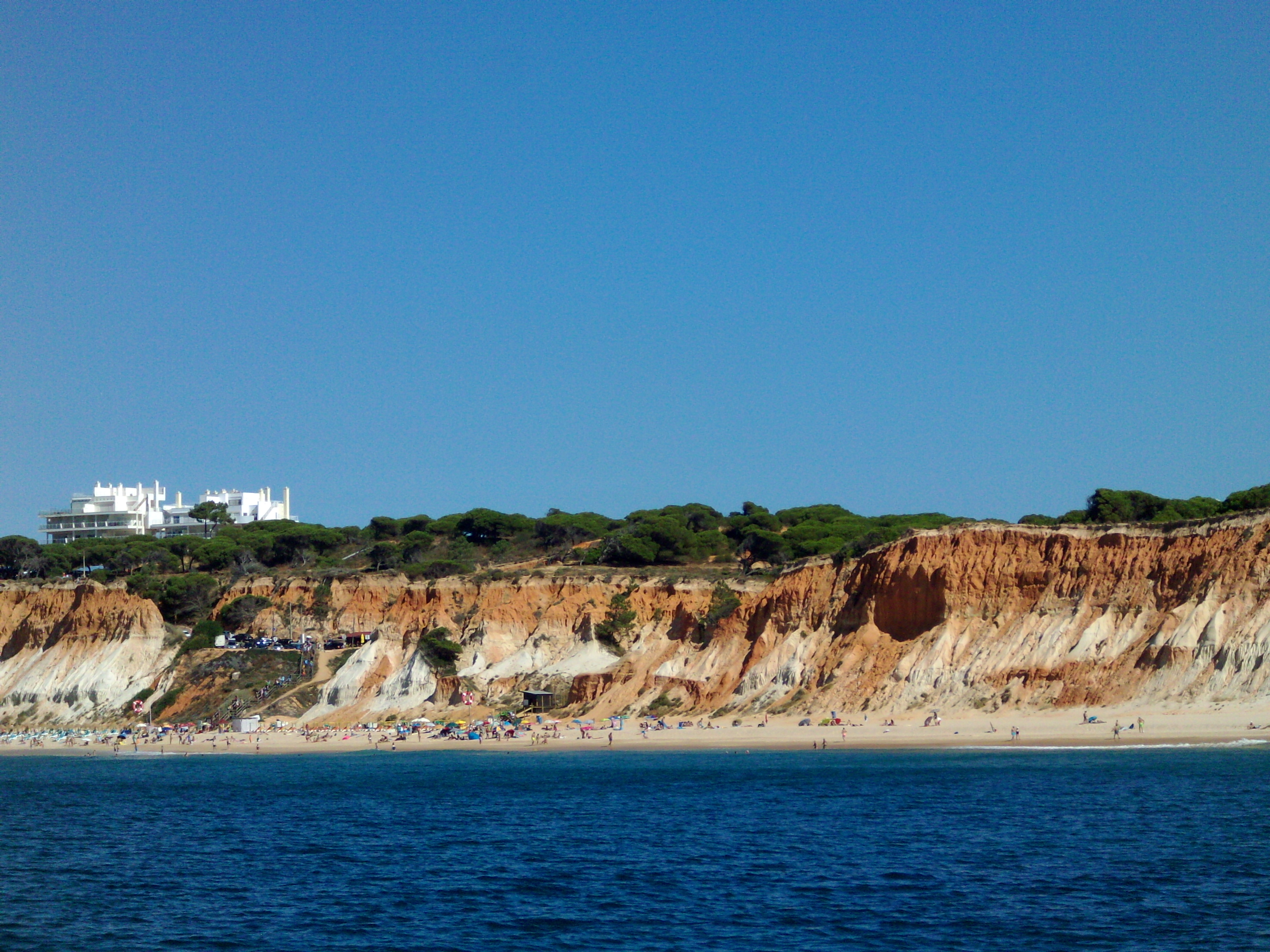
Falesia Beach seen from sea.JPG

Faro, PT

Praia da Falésia

A nearly 6 km run of cliffs banded white-to-red, the upper Quarteira Sands stained ochre by iron oxide, recording roughly five million years of deposition.

Falesia Beach seen from sea.JPG · <a href="//commons.wikimedia.org/w/index.php?title=User:Diana5cruz&amp;action=edit&amp;redlink=1" class="new" title="User:Diana5cruz (page does not exist)">Diana5cruz</a> · CC BY-SA 4.0
Substrate
sand
Nearest airport
FAO · 19 km
Tier
Featured
I’m here for
Story

Praia da Falésia runs for close to six kilometres along the central Algarve coast, from the fishing district of Olhos de Água in the west to the resort town of Vilamoura in the east. Açoteias is the western reach of that run, the stretch named for the Aldeia das Açoteias resort whose road and clifftop car parks deliver most visitors to the sand. The name on the maps, falésia, is simply the Portuguese word for cliff, and the cliff is the whole point.

What stands behind the sand at Açoteias is not scenery but a cross-section. The bluffs rise to roughly 30 to 40 metres and read in horizontal bands, greyish-white at the base shading up through cream and terracotta to deep red at the crown. Those are two named formations stacked on top of each other. The lower, paler unit is the Falésia Sands, laid down in a deltaic system during the Pliocene; the upper red unit is the Quarteira Sands, deposited on a shallow continental shelf from the Upper Pliocene into the Early-to-Middle Pleistocene. The red at the top is iron oxide. Between them sits an intermediate series of fossil-bearing deposits that marks the Pliocene-Pleistocene boundary. End to end the wall records something on the order of five million years of coastal deposition.

The cliff is also the reason the beach exists at the width it does. The sand is soft, the cliff softer, composed of sand and clay rather than hard rock, and it does not so much weather as dissolve. Winter rain carves grooves and gullies down the red faces, slabs and aprons of material slump to the base, and that eroded sediment is what continually replenishes the strand below. The beach is, in a literal sense, the cliff coming apart. The same process that makes the bands legible is the one that makes the edges dangerous: sections collapse periodically, particularly after heavy winter rainfall, and the foot of the cliff shifts year by year.

On top of the red runs a fringe of umbrella pine, the dark green crown that every wide photograph of Falésia carries above the ochre. Below it the sand is pale and fine, and the water is the central Algarve's relatively sheltered Atlantic, calmer here than the exposed west coast around Sagres. Façésia carries Blue Flag status for water quality, and the western Açoteias end, nearer Olhos de Água, fronts the high-end resort cluster of Pine Cliffs, the Sheraton Algarve and the Epic Sana, with the Alfamar resort lending its name to the eastern half of the same beach.

The honest qualifier is that Açoteias is not a wild place. It is the access-managed western portion of one of the Algarve's most heavily visited beaches, reached down clifftop steps and boardwalks from resort car parks, busy through July and August, and quiet mostly in the shoulder months and out of season. What it offers that the surrounding resorts do not is the wall itself: a five-million-year stratigraphic column you can stand at the base of, read top to bottom, and watch erode.

The spike

A nearly 6 km run of cliffs banded white-to-red, the upper Quarteira Sands stained ochre by iron oxide, recording roughly five million years of deposition.

What makes Praia da Falésia worth singling out is not a wreck or a legend but a wall, and the wall is a clock. For close to six kilometres the cliff behind the sand stands cut in horizontal bands, and those bands are not decoration. They are two stacked geological formations and the boundary between them, exposed in cross-section by the Atlantic, recording on the order of five million years of deposition. At Açoteias you can walk to the base of it and read the whole column top to bottom.

The two formations. The lower, paler unit, greyish-white shading to cream, is the Falésia Sands, deposited in a deltaic system during the Pliocene. The upper unit, the part that gives the whole beach its colour, is the Quarteira Sands, accumulated on a shallow continental shelf from the Upper Pliocene into the Early-to-Middle Pleistocene. The red and terracotta of that upper band is iron oxide, the same chemistry that reddens rust and Martian soil, staining the old shelf sands. Between the two sits an intermediate series of fossil-bearing deposits that marks the Pliocene-Pleistocene boundary, so the cliff carries not just two layers but the seam where one geological epoch gives way to the next.

What is inside the seam. That intermediate band is not empty. It holds a roughly half-metre fossiliferous conglomerate with the teeth of large sharks, Isurus and Otodus megalodon among them, alongside marine-mammal remains, the residue of a warm shallow sea. Higher in the sequence, near the top, a two-metre siltstone unit shot through with root structures is read as a paleosol, an ancient land surface, dated to roughly 125,000 years ago. So the column does not only stack sand on sand; it runs from open-shelf marine deposits through a fossil seam to a buried soil, a legible change of environment over deep time held in a single roadside cliff.

Why the bands are red, white and falling. The cliff is soft. It is sand and clay, not hard rock, and it behaves accordingly. Winter rain does not weather it slowly; it carves grooves and gullies straight down the faces, and slabs and aprons of material slump to the base. That collapsing sediment is exactly what feeds the beach: the wide pale strand below is the cliff coming apart and being spread out by the sea. The legibility of the bands and the instability of the cliff are the same fact. You can see five million years of stratigraphy precisely because the Atlantic keeps shaving the face clean, and the face keeps shaving because it is too soft to hold.

Why Açoteias, specifically. Falésia runs from the fishing district of Olhos de Água in the west to Vilamoura in the east, and the western half, the Açoteias reach near Olhos de Água, carries the tallest and most dramatic cliffs, rising to something like 30 to 40 metres. It is also the access-managed end, reached down steps and boardwalks from resort car parks, which is the honest trade: the most legible, most photographed section of the wall is also the busiest and the most built-up behind. The pine crowning the red is the umbrella pine the Pine Cliffs resort is named for. Stand at the base in the last hour of light, when the low sun saturates the iron-oxide red and throws the pine into near-black silhouette, and the cliff reads as what it is, a five-million-year section of the Algarve coast standing on end, dissolving as you watch it.

Portugal-tobefree-20160320-161057.jpg
Culture

Where it shows up

Other
  • Repeatedly ranked among Europe's best beaches

    Praia da Falésia is a recurring entry in travel-press rankings of the best beaches in the Algarve and in Europe, its banded red cliffs and pine crowns the image most often used to represent the central Algarve coast.

History
  • Olhos de Água, eyes of water

    The fishing district at the western end takes its name, eyes of water, from freshwater springs that well up through the sand at low tide, a long-recorded local feature of this stretch of coast.

Portugal-tobefree-20160320-160911.jpg
History

What happened here

  1. -5000000natural

    Deposition of the Falésia Sands begins

    The lower, greyish-white unit of the cliff, the Falésia Sands, is laid down in a deltaic system during the Pliocene, the first of the formations now exposed in the bluffs at Açoteias.

  2. -2580000natural

    The Pliocene-Pleistocene boundary is recorded

    An intermediate fossil-bearing series, including a conglomerate with shark teeth of Isurus and Otodus megalodon plus marine-mammal remains, is deposited across the Pliocene-Pleistocene boundary, separating the lower Falésia Sands from the upper red unit.

  3. -1800000natural

    Deposition of the red Quarteira Sands

    The upper, iron-oxide-red Quarteira Sands accumulate on a shallow continental shelf from the Upper Pliocene into the Early-to-Middle Pleistocene, giving the cliff its red crown and completing roughly five million years of stacked deposition.

  4. -125000natural

    A paleosol forms near the cliff top

    A roughly two-metre siltstone unit with abundant root structures, interpreted as a paleosol, forms near the top of the sequence approximately 125,000 years ago, the youngest dated layer in the exposed column.

The honest part
Its defining feature is beautiful precisely because it is dissolving, and the dissolving does not wait for the beach to be empty.

Praia da Falésia is regularly ranked among the best beaches in the Algarve and, in some travel-press lists, among the best in Europe, and the Açoteias end carries that crowd. It is fronted by major resorts, the Pine Cliffs, the Sheraton Algarve, the Epic Sana to the west and the Alfamar to the east, and in high summer the descent from the clifftop car parks funnels heavy foot traffic onto a strand that, for all its length, concentrates people around the access points. The image of an empty red-cliff beach is largely a shoulder-season or early-morning image; in July and August this is a busy resort beach with lifeguards, bars and rented sunbeds.

The cliff that draws everyone is also genuinely hazardous. The bluffs are soft sand and clay, not stable rock, and they fail. Erosion is not a slow abstraction here but the mechanism that builds the beach: winter rain cuts the gullies, slabs slump, and the base advances landward year by year. Standing tucked against the red face for shade or for a photograph puts you under material that comes down, especially after heavy rain. The reckoning of Açoteias is that its defining feature, the five-million-year wall of banded sediment, is beautiful precisely because it is dissolving, and the dissolving does not wait for the beach to be empty.

Portugal-tobefree-20160320-160906.jpg
Anatomy

The shape of the place

Olhos de Água end

5%

The western terminus of Falésia at the fishing district of Olhos de Água, where freshwater springs surface on the beach at low tide and the high-end resort cluster of Pine Cliffs and the Sheraton Algarve sits on the clifftop.

Best for Fresh fish and the tallest, most dramatic western cliffs

The most heavily resourced access on the western half; restaurants and services concentrated in the village.

Açoteias access and central sand

35%

The western reach of Falésia named for the Aldeia das Açoteias resort, reached by clifftop car park, steps and boardwalk. Lifeguarded and serviced by seasonal bars in summer; the main arrival point for the western half of the beach.

Best for Standing at the base of the banded cliff with managed access

Car parking is at the clifftop with a descent to the sand; busiest in July and August.

The banded cliff wall

50%

The 30-to-40-metre soft cliff of sand and clay rising behind the strand, banded white-to-red, the Falésia Sands below and the iron-oxide Quarteira Sands above, crowned by umbrella pine.

Best for Reading the stratigraphy and golden-hour photography

The faces are friable and shed material, especially after winter rain; do not shelter or climb against them.

Alfamar / eastern end

70%

The eastern half of the same beach, named for the Alfamar Beach & Sport Resort, where the cliff gradually loses height toward Vilamoura. A second clifftop access and car park serve this section.

Best for A quieter stretch as the cliff steps down eastward

Continuous with Açoteias along the sand; the beach runs unbroken to Vilamoura.

Landmarks

The Falésia cliffs

natural

The roughly 30-to-40-metre wall of soft sand and clay banded white-to-red, exposing the Falésia Sands and the iron-oxide Quarteira Sands across some five million years of deposition, running nearly six kilometres from Olhos de Água to Vilamoura.

Wikipedia →

Pine Cliffs resort and Sheraton Algarve

resort

The high-end resort cluster on the clifftop at the western, Olhos de Água end of the Açoteias reach, including Pine Cliffs and the Sheraton Algarve, named for the umbrella pine that crowns the red cliffs.

Aldeia das Açoteias

resort

The resort village whose road and clifftop car parks give the western reach of Falésia its name and its principal beach access, set on former farmland east of Olhos de Água.

A day here

From first light to dark

Dawn

At first light the cliffs face east-southeast across the water and catch the sun early, the red and terracotta bands lifting to their warmest while the sand is still empty and the resort car parks above are quiet. The Atlantic here is at its calmest in the morning, the annual mean wave height under a metre.

Midday

By late morning the clifftop car parks at Açoteias and Alfamar fill, and the steps and boardwalks down from the resorts feed a steady stream onto the sand. In July and August the lifeguarded central sections crowd around the access points; the bands of the cliff flatten under overhead light, the worst hour to read or photograph them.

Golden hour

Late afternoon throws the sun back onto the west-facing breaks of the cliff and saturates the ochre and red to their deepest, the pine crown going near-black above. This is the hour the wall is built for, the contrast of iron-oxide red over pale sand at its strongest as the day crowds begin to climb back up the steps.

Night

After dark the beach empties and goes unlit; there are no facilities on the sand itself once the seasonal bars close. The resorts on the clifftop carry the light and the noise, while the strand below returns to the sound of the Atlantic working at the base of the cliff.

Portugal-tobefree-20160320-160909.jpg
Sea & surf

What the water does

JFMAMJJASONDmetres (significant wave height)

Solid = typical monthly wave height; pale = the bigger days (90th pct). Offshore/regional swell from Open-Meteo Marine (ERA5 Ocean reanalysis, 2023–2024); a sheltered cove may sit calmer than this.

Mixed — usually swimmable, with a livelier season
Typical wave height
0.67 m
Biggest swell
Feb · 0.95 m
Calmest
Jul · 0.45 m
Typical period
6.8 s (wind chop)
Before you go

Things to know

Access

The beach is reached by descending from clifftop car parks at Açoteias and Alfamar via steps and boardwalks; parking is roughly 250 to 300 m from the sand and fills in summer.

Cliff safety

The cliffs are soft sand and clay that collapse periodically, especially after winter rain. Do not shelter against, undercut or climb the faces.

Facilities

Falésia carries Blue Flag status with summer lifeguards and seasonal bars at the access points; out of season the sand has no service or shade.

Best light

The cliff bands read flat at midday; early morning and the last hours before sunset saturate the red and ochre.

Sharks

No incidents on record in the global shark-attack file.

Plan

If you go

Getting there
Nearest airport
Faro - Gago Coutinho International Airport (FAO) · 19 km
Nearest town
Boliqueime · 6 km

Access is from the clifftop down steps and boardwalks at the Açoteias and Alfamar resort car parks, about 250 to 300 m above the sand, off the Aldeia das Açoteias road east of Olhos de Água. Olhos de Água village offers the most serviced western access.

What to eat & drink
Seasonal beach bars at the access points

The Açoteias and Alfamar access points carry summer beach bars and restaurants serving grilled fish, drinks and light meals to sunbed renters. They are seasonal and concentrated at the foot of the steps, not spread along the strand; out of season the sand has no service at all.

Clifftop and beach-foot access points at Açoteias and Alfamar

Grilled sardines and the Algarve cataplana

The regional Algarve table: charcoal-grilled sardines in summer and cataplana, the seafood-and-shellfish stew cooked in the hinged copper pan the dish is named for. Both are standard along this coast rather than tourist inventions.

Restaurants in Olhos de Água and Albufeira

Fresh fish at Olhos de Água

Olhos de Água, immediately west of Açoteias, is a working fishing district, and its restaurants land and grill the day's catch. The name means eyes of water, after freshwater springs that surface on the beach at low tide.

Olhos de Água seafront, west of Açoteias

Medronho

The Algarve's traditional spirit, distilled from the fruit of the arbutus (medronho) shrub that grows in the hills of the Serra. A regional drink with a long local history, served as a digestif.

Bars and restaurants across the Albufeira area

Sources & references
  1. Geoparque Algarvensis · cited 7×
  2. Geoparque Algarvensis; Falésia Beach geology
  3. Falésia Beach / Albufeira tourism
  4. Falésia Beach geology / tourism guides
  5. World Beach Tour beach data
  6. World Beach Tour beach data; visitalgarve.pt
Colophon · Provenance

Where this page comes from

Geography, facilities
OpenStreetMap (ODbL) for geometry and facility tags within 500 m of the beach centroid. GeoNames for city/airport distances.
Climate & ocean
Open-Meteo ERA5 + Marine archive, 2014–2023 monthly normals.
Photography
Archival, original tone (Tier B — Wikimedia Commons). Each image licensed per its own terms; attribution visible inline.
History & culture
Every factual claim is linked to its source in the prose above. Wikipedia citations inline. Non-wiki sources named where relevant.
Editorial voice
Register: reverent. Written to pass a local's nod test; corrections welcome.
Written by Erin Rose
Last reviewed 2026-04-19
v0.9in editorial development toward v1.0