Faro, PT

Praia da Marinha

Praia da Marinha (2012-09-27), by Klugschnacker in Wikipedia (1).JPG

Faro, PT

Praia da Marinha

A double sea-arch in 16-to-24-million-year-old limestone, reached by a steep cliff staircase and exposed only at low tide.

Praia da Marinha (2012-09-27), by Klugschnacker in Wikipedia (1).JPG · Klugschnacker · CC BY-SA 3.0
Length
3.7 km
Spring tide
2.72 m
Nearest airport
PRM · 17 km
Tier
Featured
I’m here for
Story

Praia da Marinha is a small cliff-backed cove on the Atlantic coast of the Algarve, in the civil parish of Caramujeira, municipality of Lagoa, in southern Portugal. It sits at roughly 37.0901 north, 8.4125 west, between Carvoeiro to the west and Armação de Pêra to the east, and it is reached from a clifftop car park down a steep staircase cut into the rock. The beach itself is modest, a strip of sand at the foot of orange limestone walls, but the rock is the reason people come.

At the eastern edge of the cove stands the formation that put Marinha on millions of camera rolls: a double natural arch of limestone, two openings cut side by side, which from the clifftop above reads as the letter M and, from another angle, as a pair of arches that frame the shape of a heart. Portuguese visitors call it O Coração do Algarve, the heart of the Algarve. It is one of the single most-photographed pieces of coast in the country, and the view that sells it is taken not from the sand but from the marked clifftop path that runs above the beach.

That path is the western end of the Percurso dos Sete Vales Suspensos, the Seven Hanging Valleys Trail, a clifftop route of about 5.7 kilometers each way that links Praia da Marinha with Praia do Vale de Centeanes near Carvoeiro and passes Benagil, Praia do Carvalho, and a run of sea caves and arches along the way. For many walkers the arches of Marinha are the finish line, and the beach below is where they descend to swim.

The cliffs are Miocene limestone, laid down roughly 16 to 24 million years ago when this coast was a warm shallow sea, and later dissolved and undercut by rain and Atlantic storms into the arches, pillars, and grottoes that define the Barlavento coastline. That same softness is why the wall keeps moving: the Algarve’s limestone cliffs retreat by millimeters to centimeters a year, mostly in winter storms, and along this stretch of coast collapses have killed people. The beauty and the hazard are the same rock.

Marinha is also an awarded beach. In 1998 it received the Portuguese Ministry of the Environment’s “Golden Beach” (Bandeira de Ouro) distinction for its natural qualities, and it has since been listed by the Michelin guide among the most beautiful beaches in Europe and the world. The recognition is deserved and it is also the problem: a tiny cove with a 32-space car park became a bucket-list stop, and on a high-summer afternoon the access road can be closed by police because there is nowhere left to put a car.

The access shapes everything about a visit. There is no road to the sand, only the staircase; there are no sunbeds or umbrellas to hire, no shower; a single seasonal snack bar at the foot of the steps is the only place to buy food or water on the beach. Lifeguards patrol roughly June to mid-September. The water rarely climbs above about 22 degrees Celsius even in August. And the arches you came for are only fully walkable at low tide, when the sea pulls back from the foot of the cliff; come at high water and the waves run right up to the rock.

The spike

A double sea-arch in 16-to-24-million-year-old limestone, reached by a steep cliff staircase and exposed only at low tide.

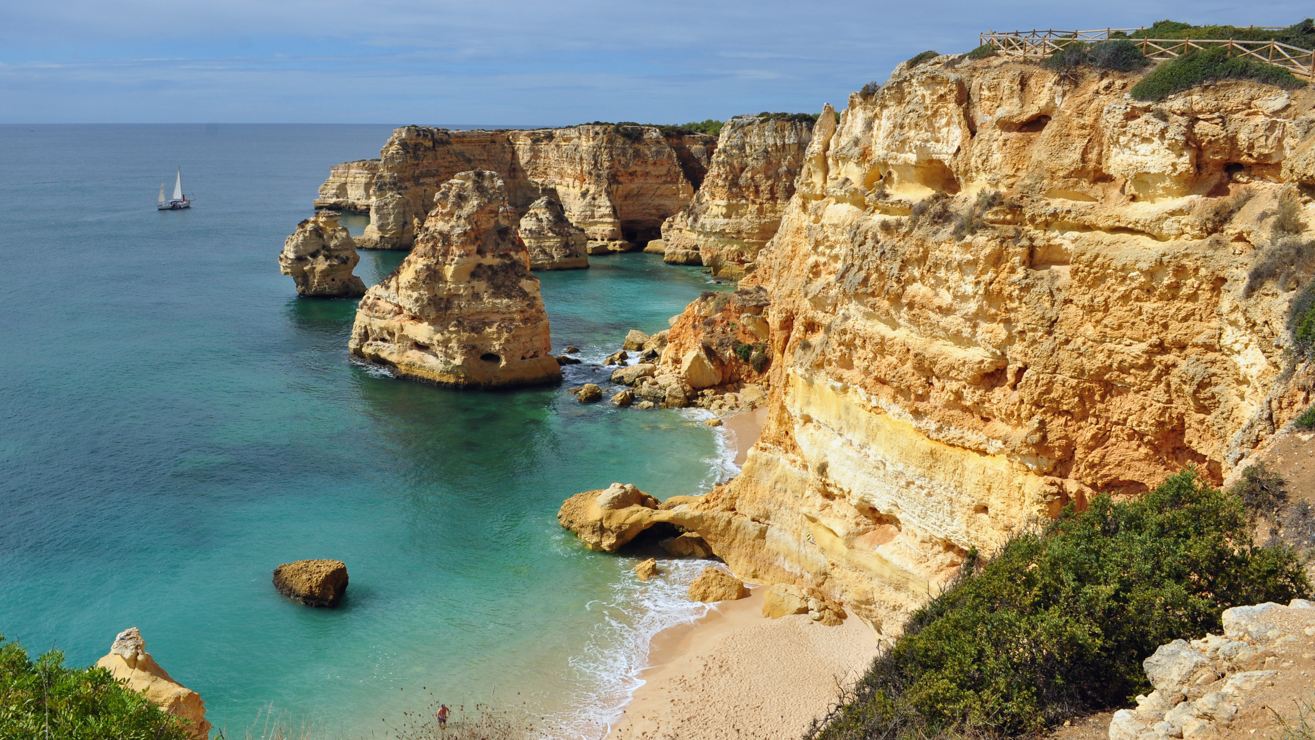
The thing that makes Praia da Marinha singular is one rock formation, and it is worth being precise about what it is and why it matters. At the eastern end of this small cove, the Atlantic has cut two arches side by side into the orange limestone wall, leaving a double sea-arch that stands out from the cliff like a pair of legs braced in the water. Seen from the clifftop directly above, the two openings and the pillar between them read unmistakably as the letter M — which is why it is often just called the “M rock” — and from a slightly different angle the curve of the arches frames a heart, the form Portuguese visitors named O Coração do Algarve, the heart of the Algarve. This is not a marketing slogan retrofitted onto a pretty beach. The arches are the most-photographed single formation on a coastline that is itself the most photographed in Portugal, and the canonical image of them — turquoise water threading two stone openings under a ribbed orange cliff — is taken from above, on the trail, not from the sand below.

To understand the arches you have to understand the rock, because the formation is a snapshot of a process still running. The cliffs at Marinha are Miocene limestone, deposited between roughly 16 and 24 million years ago, when the Algarve coast lay under a warm, shallow sea and successive layers of carbonate sediment, rich in fossils, built up into the pale-to-orange stone you see today. Limestone is soluble. Over the millions of years since the sea level fell and exposed it, rainwater seeping along joints and bedding planes has dissolved the rock from within — the process geologists call karstification — while the Atlantic has attacked it from outside, prying open every crack with the hydraulic shock of waves and winter storms. The result, all along this Barlavento stretch between Portimão and Arm: a fantasy inventory of sea caves, blowholes, freestanding pillars, and arches, of which Marinha’s double arch is simply the most photogenic specimen. An arch is a transitional shape. The sea hollows a cave into the base of a headland; when two caves meet, or a cave breaks through, an arch is born; and when the span finally fails, the arch collapses and leaves a freestanding stack offshore. Marinha’s twin arch is, geologically, a moment caught between cave and ruin.

That is the uncomfortable corollary of the spike, and it is honest to say it plainly: the formation that makes this beach famous is actively eroding, and the cliffs around it are dangerous. Measurements along the Algarve coast put the cliff-retreat rate at somewhere between a couple of millimeters and a few centimeters a year, concentrated in winter, with occasional sudden failures that move far more rock at once. This is not abstract. The Algarve’s soft limestone cliffs have killed beachgoers — most infamously at Maria Luísa beach in Albufeira, where a cliff collapse in August 2009 buried and killed five people — and the regional authorities now run summer campaigns under the blunt slogan “A natureza não avisa,” nature doesn’t warn, urging people to keep clear of the cliff bases. The same erosion that carved Marinha’s arches is the reason you should not sit, picnic, or shelter directly beneath an overhang anywhere on this coast.

The second half of what makes Marinha singular is access, because the rock is hard to reach on purpose and on accident at once. There is no road down to the cove. From the clifftop car park you descend a steep staircase — commonly described as roughly 100 to 150 steps, the lower flights cut into or built against the rock and genuinely steep near the bottom — a five-to-ten-minute climb down that is explicitly not suitable for anyone with reduced mobility, and a harder climb back up in the heat. The car park itself holds about 32 vehicles. That number is the entire bottleneck of Marinha’s fame: a beach that appears on “most beautiful in the world” lists has parking for thirty-two cars, and in July and August it fills early enough that police close the approach road, sometimes about a kilometer out, once it is full. The single-track final stretch of road compounds it. The practical consequence is that the only sane way to experience Marinha in summer is to arrive at or before dawn, or in May and early June and the shoulder season, when the staircase and the sand are quiet.

The arches add one more constraint that catches first-time visitors: the tide. At low tide the sea withdraws from the foot of the cliff, the sand widens, the smaller cove to the side joins the main beach, and you can walk to and around the base of the arch formation and, on calm days, swim through to the adjacent grottoes. At high tide the picture inverts — waves run all the way to the cliff foot, the walkable sand shrinks, and the arches become something you look at rather than stand under. Because the beach faces a relatively sheltered aspect, currents here are gentle and the water is usually calm enough for swimming and snorkeling, which is why families tolerate the staircase; but the timing of when you can actually reach the arches is dictated by the tide table, not the daylight.

Finally, Marinha is the hinge of the Algarve’s best-known coastal walk, and that context is part of why the arches are so heavily photographed. The beach forms the eastern trailhead of the Percurso dos Sete Vales Suspensos, the Seven Hanging Valleys Trail, named for seven valleys that ancient streams carved into the cliffs and that now hang above the sea. The marked route runs about 5.7 kilometers one way (roughly 11.4 there and back) west to Praia do Vale de Centeanes near Carvoeiro, taking about two and a half to three hours each way, and on its course it passes the Benagil sea cave, Praia do Carvalho, and a string of arches and blowholes. The trail’s most reproduced single image is the view down onto Marinha’s double arch from the clifftop, which means the formation is photographed both by the day-trippers who climb down the staircase and by the hikers who never descend at all. The beach is famous twice over: as a destination you climb down to, and as a viewpoint you walk above. The rock is the same; what changes is whether you are standing on the sand or looking down at it.

Put together — a double arch of fossil-bearing Miocene limestone, photographed from above, walkable only at low tide, reached only by a steep staircase, served by a 32-car lot, eroding measurably every winter on a coast that has killed people — Praia da Marinha is not a beach that happens to have a nice rock. It is a rock formation that happens to have a beach at its foot, and almost everything inconvenient about visiting it is downstream of that one fact.
Algarve-1.jpg
Culture

Where it shows up

Other
  • Golden Beach (Bandeira de Ouro) distinction · 1998
    Portuguese Ministry of the Environment

    In 1998 the Ministry of the Environment awarded Praia da Marinha the Golden Beach distinction for its outstanding natural qualities, an early official recognition that anchored its reputation.

  • Michelin guide “most beautiful beaches” listing
    Michelin guide

    The Michelin guide has listed Praia da Marinha among the ten most beautiful beaches in Europe and the hundred most beautiful in the world, recognition repeated across travel media and central to the beach’s fame.

  • CNN 20 most beautiful cliff beaches · 2018
    CNN

    In 2018 CNN named Marinha among the twenty most beautiful beaches in the world in the cliff-beach category, one of several international rankings that turned a small cove into a bucket-list stop.

  • “A natureza não avisa” cliff-safety campaign · 2025
    Algarve civil-protection and maritime authorities

    Recurring summer awareness campaigns under the slogan “nature doesn’t warn” distribute leaflets in Portuguese and English and urge beachgoers to keep clear of cliff bases, a direct response to the fatal cliff-collapse history of the Algarve’s limestone coast.

Praia da Marinha (2012-09-27), by Klugschnacker in Wikipedia (31).JPG
History

What happened here

  1. -16000000natural

    Miocene limestone laid down

    Between roughly 24 and 16 million years ago, during the Miocene, a warm shallow sea deposited the fossil-bearing carbonate sediment that hardened into the orange limestone cliffs of this coast, the raw material the sea later carved into Marinha’s arches.

    Wikipedia →
  2. 1998policy

    Golden Beach distinction awarded

    The Portuguese Ministry of the Environment awards Praia da Marinha the “Golden Beach” (Bandeira de Ouro) distinction for its outstanding natural qualities, an early formal recognition of the cove’s significance.

    Wikipedia →
  3. 2009disaster

    Maria Luísa cliff collapse kills five

    On 22 August 2009 a cliff collapsed at Maria Luísa beach in nearby Albufeira, on the same soft Algarve limestone, burying and killing five people and injuring others — the defining warning of the cliff-collapse risk along this coast.

  4. 2018cultural

    Named among the world’s most beautiful cliff beaches

    CNN names Praia da Marinha among the 20 most beautiful beaches in the world in the category of beaches with cliffs, cementing its status on international lists.

    Wikipedia →
  5. 2019cultural

    Named best Portuguese beach to visit in September

    Marinha is selected as the Portuguese beach with the award for best spot to visit in September, recognition tied to its shoulder-season conditions when crowds and parking pressure ease.

    Wikipedia →
  6. 2023policy

    Benagil cave access restricted

    From 10 September 2023 the Portuguese maritime authority restricts how visitors may enter the nearby Benagil sea cave, a highlight of the Seven Hanging Valleys trail past Marinha, after a summer of dangerous overcrowding and incidents.

  7. 2024policy

    Swimming and self-guided kayak into Benagil banned

    By order of the maritime authority, swimming and self-guided kayak or SUP entry into Benagil Cave are banned from July 2024 following repeated drownings and boat incidents, tightening the rules on the most famous stop along the coastal trail.

  8. 2025policy

    Renewed cliff-danger campaign

    Algarve civil-protection and maritime authorities run another summer awareness campaign, “A natureza não avisa” (nature doesn’t warn), distributing leaflets and warning beachgoers to keep clear of cliff bases after fresh rockfalls along the coast.

The honest part
It is a rock formation that happens to have a beach at its foot — and the same erosion that carved its arches is the reason you should not stand beneath them.

The honest truth about Praia da Marinha is that its fame outgrew its capacity, and that the rock everyone comes to photograph is slowly destroying itself. A cove with parking for about 32 cars and a single steep staircase down to the sand now appears on global “most beautiful beach” lists, and the result in July and August is a car park full by mid-morning, an access road that police close roughly a kilometer out, and a queue of people on a staircase that is not built for crowds and not usable by anyone with reduced mobility. There are no sunbeds, no showers, and only one seasonal snack bar; the sand you actually get depends on the tide, and at high water the arches you came for are walled off by the sea.

The deeper reckoning is geological. The orange cliffs here are soft Miocene limestone, retreating by millimeters to centimeters a year and capable of sudden collapse — the same Algarve rock that killed five people at Albufeira’s Maria Luísa beach in 2009, which is why the authorities now plaster the coast with “nature doesn’t warn” signs every summer. The double arch of Marinha is mid-process: a cave that became an arch and will, on a timescale no one can promise, become a fallen stack. Standing under the cliff for the photograph is exactly the thing the safety campaigns ask you not to do.

Praia da Marinha (2012-09-27), by Klugschnacker in Wikipedia (86).JPG
Anatomy

The shape of the place

Seven Hanging Valleys trailhead

15%

The clifftop western trailhead of the Percurso dos Sete Vales Suspensos, where the marked path leaves toward Benagil, Praia do Carvalho, and Vale de Centeanes, about 5.7 km away. The classic arch viewpoint is along here.

Best for The canonical clifftop view and the coastal hike

Unfenced clifftop in places; stay on the marked path and back from the edge.

The main sand

50%

The central strip of sand at the foot of the staircase, sheltered and calm, with gentle currents that make it usable for swimming and snorkeling. Its width shrinks and grows with the tide.

Best for Swimming and families

Only seasonal snack bar and the toilets are here; no sunbeds or showers.

The side cove

70%

A smaller cove beside the main beach, separated by rock that the sea covers at high water. At low tide it joins the main sand and opens the walk toward the arches and grottoes.

Best for Quieter low-tide swimming and rock-pooling

Check the tide table before crossing; the link is cut off as the tide rises.

The double sea-arch

85%

The twin limestone arch at the eastern edge of the cove, the “M rock” or O Coração do Algarve. Walkable around its base at low tide; at high tide the sea runs to the cliff foot and it becomes a view only.

Best for The defining photograph and low-tide exploring

Best shot is from the clifftop path above, not the sand. Don’t linger directly under the overhang.

Landmarks

The double sea-arch (O Coração do Algarve / “M rock”)

natural

A twin natural arch cut by the Atlantic into the Miocene limestone at the eastern edge of the cove. From the clifftop it reads as the letter M; from another angle it frames a heart, which is why Portuguese visitors call it the heart of the Algarve. It is the most-photographed formation on Portugal’s most-photographed coast, and is walkable at its base only at low tide.

Wikipedia →

Percurso dos Sete Vales Suspensos (Seven Hanging Valleys Trail)

trail

A clifftop coastal trail of about 5.7 km each way running west from Praia da Marinha to Praia do Vale de Centeanes near Carvoeiro, named for seven valleys ancient streams carved into the cliffs. It passes the Benagil cave, Praia do Carvalho, and a sequence of arches and blowholes, and its most reproduced image is the view down onto Marinha’s double arch.

Benagil sea cave

natural

A large domed sea cave with a circular opening in its roof (an “eye” to the sky), on the coast just west of Marinha and a highlight of the Seven Hanging Valleys trail. After repeated drownings and boat incidents, the maritime authority restricted access from September 2023 and banned swimming and self-guided kayak entry from July 2024.

A day here

From first light to dark

Dawn

Before the heat the car park still has spaces and the staircase is empty; arriving at dawn is the only reliable way to beat the summer closure of the access road. If the tide is out, the sand is at its widest and you can walk to the foot of the double arch with the cove almost to yourself.

Midday

By late morning in summer the 32-car park is full, the road may be closed about a kilometer out, and the staircase carries a steady line of people up and down. The water sits calm and clear, rarely above 22 degrees, and the arches are at their most photographed from the clifftop path above.

Golden hour

Late afternoon thins the day-trippers as the road reopens and cars leave; the orange limestone deepens in the low light, which is when the cliffs and the arch photograph best from the Seven Hanging Valleys trail above the beach.

Night

There are no lights and no facilities open after the snack bar closes; the cove empties out. If a low tide falls after dark the sea is far off the cliff, but the unlit, unguarded staircase makes the descent a poor idea once the light goes.

Compare

How it ranks

Peak warmth
Warmer than 86% of beaches in its country
Peak-month high ≈ 28°C

Ranked against every beach in our database — 228,000+ worldwide.

Praia da Marinha (2012-09-27), by Klugschnacker in Wikipedia (64).JPG
Sea & surf

What the water does

JFMAMJJASONDmetres (significant wave height)

Solid = typical monthly wave height; pale = the bigger days (90th pct). Offshore/regional swell from Open-Meteo Marine (ERA5 Ocean reanalysis, 2023–2024); a sheltered cove may sit calmer than this.

Mixed — usually swimmable, with a livelier season
Typical wave height
0.7 m
Biggest swell
Feb · 0.99 m
Calmest
Jul · 0.47 m
Typical period
7 s (wind chop)
Before you go

Things to know

The stairs are the access

There is no road to the sand. You descend a steep staircase of roughly 100–150 steps, steepest near the bottom, a 5–10 minute climb down and a harder climb back up. It is not suitable for anyone with reduced mobility, and there is no step-free route.

Parking is tiny — come early

The clifftop car park holds about 32 cars and the final road stretch is single-track. In July and August it fills by mid-morning and police may close the approach road about a kilometer out. Arrive at or before dawn, or visit in May, early June, or September.

Time the tide for the arches

The double arch is walkable at its base only at low tide, when the sea pulls back and the side cove joins the main beach. At high tide waves reach the cliff foot and the arch becomes a view, not a place you can stand under. Check a tide table before you go.

Mind the cliffs

The orange limestone is soft and eroding — it retreats by millimeters to centimeters a year and can fail suddenly, as a 2009 collapse at Albufeira’s Maria Luísa beach (five dead) showed. Don’t sit, picnic, or shelter directly beneath overhangs. There is one seasonal snack bar and no showers; bring water.

Sharks

No incidents on record in the global shark-attack file.

Plan

If you go

Getting there
Nearest airport
Portimão Airport (PRM) · 17 km
Nearest town
Carvoeiro · 4 km

Praia da Marinha is in Caramujeira, Lagoa, signposted off the M1273 / Estrada da Praia da Marinha, about 25 minutes by car from Portimão, 30 from Albufeira, and 50 from Faro airport; the last stretch is single-track. There is no road to the sand: park in the clifftop car park (about 32 spaces, with the only toilets) and descend a steep staircase of roughly 100–150 steps, a 5–10 minute climb down that is not step-free and not suitable for reduced mobility. In high summer arrive at or before dawn, because the lot fills early and police close the approach road when it is full. You can also reach the cove on foot via the Seven Hanging Valleys trail from Carvoeiro, or view it from boat trips out of Benagil, Carvoeiro, Portimão, and Albufeira.

When to go
  • Lifeguard season · Roughly June to mid-September

    Lifeguards patrol Praia da Marinha through the core summer months, the same window when the staircase, the 32-car park, and the access road are under the most pressure and when the road may be closed by police once full.

  • Seven Hanging Valleys hiking season · Spring and autumn, avoiding peak summer heat

    Walkers favor the cooler shoulder months for the ~5.7 km clifftop trail from Marinha toward Carvoeiro, when temperatures are kinder on the unshaded path and the arch viewpoints are less crowded.

What to eat & drink
The beach snack bar

A single seasonal snack bar at the foot of the staircase is the only place to buy food, drink, or use a toilet on the beach itself; there are no shops, showers, or sunbeds. Reported as small and reasonably priced, but do not count on it out of season — carry water for the climb back up.

At the base of the staircase, on the sand at Praia da Marinha

Cataplana de marisco

The Algarve’s signature seafood stew, clams, prawns and fish steamed in a hinged copper cataplana pan, is the regional dish to eat after the hike rather than on the beach. It is a staple of restaurants in nearby Carvoeiro and Armação de Pêra.

Restaurants in Carvoeiro and Lagoa, a short drive inland

Sardinhas assadas

Charcoal-grilled sardines are the everyday summer food of the Portuguese coast, sold from grills in the fishing villages along this stretch in the warmer months. They are a regional staple, not a Marinha-specific offering.

Grills and tascas in the surrounding Algarve villages

Dom Rodrigo and almond sweets

The Algarve’s traditional sweets are built on its almond and fig groves — Dom Rodrigo, made of egg-yolk threads and almond, and marzipan figures are the classic regional confections, sold in pastelarias across Lagoa and the surrounding towns.

Pastelarias in Lagoa and nearby Algarve towns

Sources & references
  1. Wikipedia: Praia da Marinha · cited 5×
  2. zigzagonearth; Geoloquium · cited 2×
  3. Portugal Resident; The Portugal News
  4. Earth Trekkers; A Couple Days Travel
  5. Algarve Addicts; RandomTrip
  6. Sul Informação; The Portugal News
  7. 5Emotions Algarve; Portugal Lovers
  8. algarve-tourist.com; Drifter Planet
  9. algarve-tourist.com
  10. PandoTrip; zigzagonearth
  11. algarve-tourist.com; zigzagonearth
Colophon · Provenance

Where this page comes from

Geography, facilities
OpenStreetMap (ODbL) for geometry and facility tags within 500 m of the beach centroid. GeoNames for city/airport distances.
Climate & ocean
worldclim_v2.1_2.5m
Tides
eot20
Photography
Archival, original tone (Tier B — Wikimedia Commons). Each image licensed per its own terms; attribution visible inline.
History & culture
Every factual claim is linked to its source in the prose above. Wikipedia citations inline. Non-wiki sources named where relevant.
Editorial voice
Register: reverent. Written to pass a local's nod test; corrections welcome.
Written by Erin Rose
Last reviewed 2026-04-19
v0.9in editorial development toward v1.0