Galicia, ES

Praia das Catedrais

Ribadeo. Playa de las catedrales.jpg

Galicia, ES

Praia das Catedrais

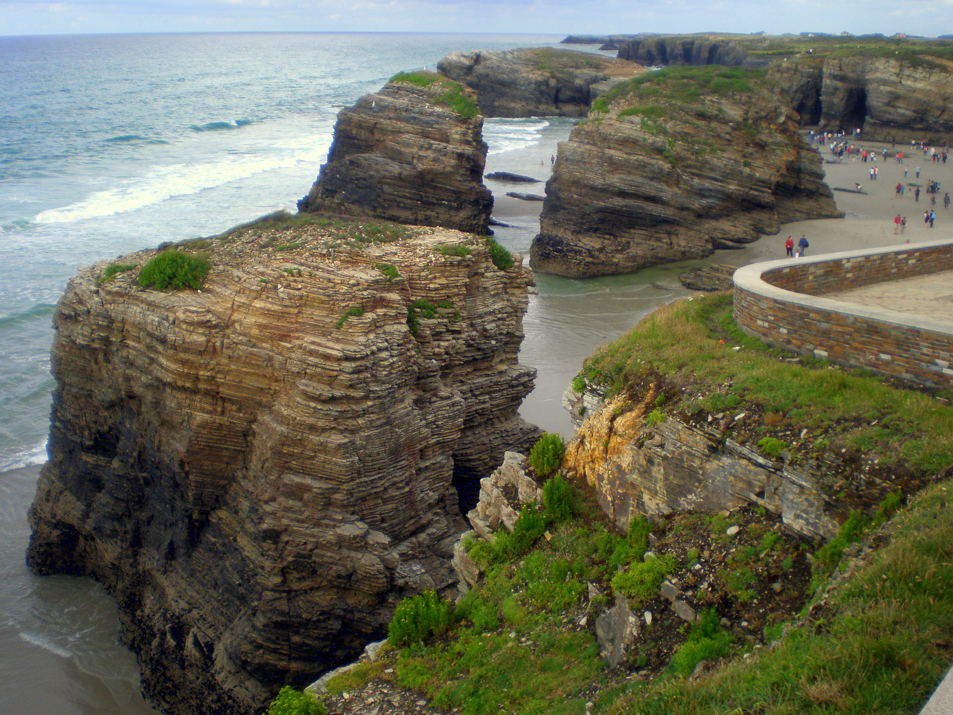
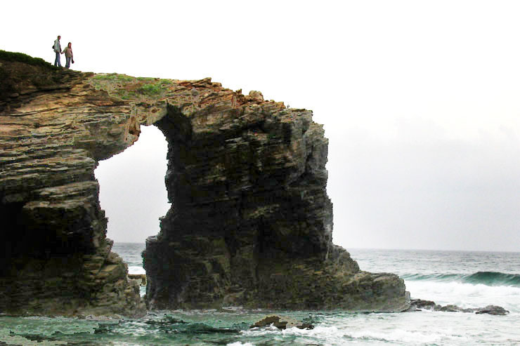
The sea cut 30-metre arches into slate and schist here; you can only walk among them at low tide, and since 2015 summer entry is capped and permitted.

Ribadeo. Playa de las catedrales.jpg · <a rel="nofollow" class="external text" href="https://www.flickr.com/photos/11198957@N08">Jaume Meneses</a> · CC BY-SA 2.0
Substrate
sand
Spring tide
3.37 m
Nearest airport
OVD · 90 km
Tier
Featured
I’m here for
Story

Praia das Catedrais sits on the Cantabrian coast of Galicia, in the municipality of Ribadeo, Lugo province, about ten kilometres west of the town of Ribadeo. Its official Galician name is Praia de Augas Santas — 'Beach of the Holy Waters,' a reference to a spring once believed to have healing properties. The tourist name, Praia das Catedrais (Playa de las Catedrales in Spanish), describes what the sea has carved into the cliffs: arches and rock columns that resemble the flying buttresses and naves of a Gothic cathedral.

The formations are made of slate and schist, with quartzite, and the rock itself is roughly 500 million years old. The tallest arches reach about 30 metres. They are not permanent. The sea that built them is still cutting, and pieces fall: a 25-year-old visitor was killed by a falling rock inside one of the caves in March 2018, and a partial arch collapse on the night of 29 November 2020 brought down a rock face six metres wide and ten metres high.

The single fact that governs every visit is the tide. At high tide the Cantabrian Sea covers the sand completely and you see almost nothing — a cliff line and water. Only at low tide does the sand drain out and the arches stand clear, and the usable window is roughly a few hours on either side of low water. People who arrive without checking a tide table routinely find a flooded beach. People who walk out among the arches and lose track of the rising water get cut off, and the local emergency services have run rescues for exactly this reason.

The beach was declared a Natural Monument by the Xunta de Galicia in 2005, and it is also a Natura 2000 Special Conservation Zone (ZEC ES1120005) within the Río Eo, Oscos e Terras de Burón Biosphere Reserve. In 2015, after a single day the previous summer had drawn an estimated 16,000 people to a beach with a four-hour viewing window, the Xunta introduced an access cap and a free-permit system for the high season.

That permit system is now the defining bureaucratic fact of the place: a daily limit of 4,812 visitors, enforced during Easter Week and every day from 1 July to 30 September, with free reservations made in advance through the regional government's website. Outside those dates no permit is needed — but the tide still rules, and in the off-season the weather on this stretch of the Atlantic-fed Cantabrian coast is frequently grey, wet, and cold.

The result is a place that is genuinely a natural wonder and genuinely difficult to experience well: you have to want it at the right hour, with the right paperwork, and you have to respect that the cathedrals are still being demolished by the same sea that built them.

The spike

The sea cut 30-metre arches into slate and schist here; you can only walk among them at low tide, and since 2015 summer entry is capped and permitted.

## The geology, the tide, and the permit: how a beach becomes a rationed monument

Praia das Catedrais is a single geological idea repeated along about a kilometre and a half of cliff between the smaller beaches of Augasantas and Carricelas: the sea, given enough time, will hollow a hard rock until the rock becomes an arch, and then it will bring the arch down.

The rock. The cliffs are built of slate and schist, with bands of quartzite, and the stone is on the order of 500 million years old — laid down as sediment along ancient southern-hemisphere shores in the early Palaeozoic. Around 350 million years ago, the collision of the supercontinents Laurussia and Gondwana folded and compressed those sediments into a mountain range, tilting the rock layers and setting up the steeply-bedded, fractured cliffs you see today. That tilt matters: it gives the sea vertical planes of weakness to exploit. The formations sit on the *rasa cantábrica*, the flat coastal platform that runs along this part of the north Spanish coast.

How an arch is made. The local interpretation, given by the Ribadeo tourism authority, describes a four-stage sequence. First, wave action widens existing fractures in the cliff. Second, that erosion deepens into sea caves — known locally as *furnas*. Third, neighbouring caves connect, and where a cave roof collapses it opens a vertical shaft to the surface, locally called an *ollo* ('eye'). Fourth, continued erosion punches a cave all the way through a headland and the roof survives as an arch — at which point the structure is, by its nature, fragile and unstable. The tallest of these arches reaches roughly 30 metres, the height of a real cathedral vault, which is where the name comes from.

The instability is not theoretical. An arch is a transitional form — the stage between a cave and a sea stack. It exists only until the span fails. On the night of 29 November 2020, one of the named arches partially collapsed; the detached face measured about six metres wide and ten metres high. It happened at night, in winter, with no one underneath. The 2020 fall followed a fatal incident: in March 2018 a 25-year-old woman, Inés Baladrón Zorita of Laguna de Duero, was killed when a rock fell on her head inside one of the caves. In 2026 the Audiencia Nacional found the Spanish State, the Xunta, and the Ribadeo council partly liable and ordered compensation. The lesson the geology teaches is the same as the safety warning: these formations are actively eroding, and standing directly under or inside them carries real risk.

The tide is the gate. The whole experience of the beach — being able to walk on the sand at all, let alone among the arches — depends on the tide being out. At high water the sea covers the beach floor completely and the arches become inaccessible sea-cliffs with water at their feet. At low water the sand re-emerges and you can walk through and beneath the formations. The viewing window is short — roughly a couple of hours either side of low tide — and it shifts by about fifty minutes each day, tracking the lunar cycle. This is why a tide table is not optional. It is also why the beach gets people into danger: the water comes back, and visitors who have wandered out among the arches and lost track of the time can be cut off against the cliff, which is exactly the scenario the local rescue services have had to respond to.

The permit is the human-management layer on top of the natural one. For most of its history the beach had no entry control. By the early 2010s its fame — a 2012 traveller poll ranked it the best beach in Spain — had turned the tidal window into a crush. In the summer before the cap, a single day reportedly drew around 16,000 people to a beach you can only stand on for about four hours. In 2015, under a Special Protection Plan agreed between the Ribadeo council and the Xunta de Galicia, the regional government imposed a daily limit of 4,812 visitors and a free-permit requirement for the busy periods: every day in Easter Week (Semana Santa) and every day from 1 July to 30 September. Permits are free, reserved in advance through the Xunta's official site, and also bundled in for guests of nearby accommodation, for users of the Bus Praia shuttle from Ribadeo, and for arrivals by taxi. Outside those dates the cap and the permit fall away — but the tide does not.

So the beach asks two questions of every visitor, and they are different questions. The Xunta's question — *do you have a permit, in high season?* — protects the site from people. The sea's question — *is the tide out, and do you know when it turns?* — protects people from the site. You can satisfy the first with a free online booking. The second you satisfy only by reading a tide table and watching the water.

Xistos na praia de Augas Santas ou das Catedrais. Devesa. Ribadeo. Galiza-07.jpg
Culture

Where it shows up

natural
  • One of National Geographic's seven natural wonders of Galicia · 2024
    National Geographic

    As Catedrais is regularly named among Galicia's defining natural wonders in Spanish travel media, including a 2024 National Geographic-cited list of the seven natural marvels of Galicia.

cultural
  • TripAdvisor Travellers' Choice — best beach in Spain (2012) · 2012
    TripAdvisor

    The 2012 Travellers' Choice poll that ranked As Catedrais best beach in Spain, second in Europe and sixth worldwide — the recognition that drove the visitor surge leading to the 2015 cap.

place_name
  • 'Augas Santas' — the holy-waters name
    Galician oral tradition

    The official name Praia de Augas Santas ('Beach of the Holy Waters') is older than the cathedral nickname and refers to a spring once believed to have curative powers — a layer of folk tradition beneath the geological fame.

As Catedrais Lugo Galicia.jpg
History

What happened here

  1. -500000000geological

    The slate and schist are laid down

    The sediments that become the cliffs' slate, schist and quartzite are deposited along ancient southern-hemisphere shores in the early Palaeozoic, roughly 500 million years ago.

    Wikipedia →
  2. -350000000geological

    Laurussia–Gondwana collision folds the rock

    Around 350 million years ago the collision of the supercontinents Laurussia and Gondwana folds and uplifts the sediments into a mountain range, tilting the rock layers and creating the steeply-bedded, fractured cliffs the sea later carves.

    Wikipedia →
  3. 2005political

    Declared a Natural Monument

    The Xunta de Galicia declares Praia de Augas Santas a Natural Monument. The site is also part of the Natura 2000 network as Special Conservation Zone ES1120005, within the Río Eo, Oscos e Terras de Burón Biosphere Reserve.

    Wikipedia →
  4. 2012cultural

    Voted best beach in Spain

    A TripAdvisor Travellers' Choice poll ranks As Catedrais the best beach in Spain, second in Europe and sixth in the world — a turning point in the international fame that soon overwhelmed the tidal viewing window.

    Wikipedia →
  5. 2015political

    Visitor cap and free-permit system introduced

    Under a Special Protection Plan agreed between the Ribadeo council and the Xunta, the regional government imposes a daily limit of 4,812 visitors and a free-permit requirement for Easter Week and 1 July–30 September. The previous summer a single day had reportedly drawn around 16,000 people to a beach with a roughly four-hour tidal window.

    Wikipedia →
  6. 2018event

    Fatal rockfall in a cave

    On 31 March 2018, a 25-year-old visitor, Inés Baladrón Zorita of Laguna de Duero, is killed when a rock falls on her head inside one of the beach's caves. In 2026 the Audiencia Nacional finds the State, the Xunta and the Ribadeo council partly liable and orders compensation.

    Wikipedia →
  7. 2020event

    Partial collapse of an arch

    On the night of 29 November 2020, erosion brings down part of one of the iconic arches; the detached rock face measures about six metres wide and ten metres high. The collapse happens at night with no one beneath it.

    Wikipedia →
The honest part
The Xunta's permit protects the site from people. The tide table protects people from the site. They are not the same protection, and you need both.

Three hard facts sit under the postcard.

**The arches can kill you, and have.** This is an actively eroding cliff, not a stable monument. In March 2018 a 25-year-old visitor died inside one of the caves when a rock fell on her head; in 2026 a court found the State, the Xunta and the Ribadeo council partly liable. On the night of 29 November 2020 a section of one arch — roughly six by ten metres — collapsed. Standing directly beneath or inside the formations carries genuine, documented risk, and you should not linger under overhangs.

**The tide cuts people off.** The beach is only walkable for a few hours around low water; at high tide it floods completely. Visitors who go out among the arches and lose track of the returning sea get trapped against the cliff, and local emergency services have had to perform rescues. Check the tide table before you go, time your visit to low tide, and start walking back before the water turns — there is no improvising your way out of a flooded cove against a vertical cliff.

**Access is rationed in high season.** Since 2015 the site has been capped at 4,812 visitors per day during Easter Week and from 1 July to 30 September, with a free permit required in advance. The cap exists because a single pre-cap summer day drew an estimated 16,000 people to a four-hour beach. Show up in August without a booking and you may not get in — and even with a permit, you are sharing a small tidal window with thousands of others.

As Catedrais - panoramio.jpg
Anatomy

The shape of the place

Praia de Augasantas (west)

15%

The western neighbouring beach that gives the monument its official name. Part of the same slate-and-schist coastal platform; quieter than the central arch zone.

Best for Less-crowded low-tide walking, continuing the coastal-platform walk west

Same tidal rules apply — it floods too.

The arches (central low-tide zone)

50%

The core of the monument — the cluster of 30-metre arches, columns and caves carved into the slate-and-schist cliff between Augasantas and Carricelas. Accessible on the sand only at low tide; this is the part that floods completely at high water.

Best for Walking among and beneath the formations at low tide, photography of arches-within-arches

Do not stand under overhangs — this cliff is actively eroding (fatal rockfall 2018, partial collapse 2020). Watch the returning tide and walk back early.

Clifftop walkways and viewpoints

50%

Elevated wooden walkways and railed viewpoints along the cliff edge, built as part of the post-2015 protection plan to route foot traffic above the fragile zones. The only way to 'see' the beach when the tide is in.

Best for Overhead views of the arches at any tide, accessible viewing, the safe option at high tide or after dark

Stay behind the railings — the cliff edge is undercut. This is where you watch from when the sand is flooded.

Praia de Carricelas (east)

85%

The eastern neighbouring beach bounding the run of arches. Together Augasantas and Carricelas frame the roughly 1.5 km of carved cliff that makes up the named formations.

Best for Quieter low-tide exploration at the eastern end of the formations

Same tidal cut-off risk as the central zone.

Landmarks

The 30-metre arches

natural

The flying-buttress sea arches that give the beach its name — up to about 30 metres high, cut into 500-million-year-old slate and schist, visible on the sand only at low tide.

Wikipedia →

Sea caves and furnas

natural

The caves (furnas) and roof-collapse shafts (ollos) that are the intermediate stage between fracture and arch. Walking into them is possible only at low tide and carries rockfall risk — a 2018 fatality occurred inside one.

Wikipedia →
A day here

From first light to dark

Dawn

Whether dawn is any good depends entirely on whether low tide falls near it. If the tide table puts low water in the early morning, this is the best hour: the sand is freshly drained, the wet slate mirrors the grey-to-pink sky, and the high-season crowds and their permits don't start until the daytime window. If low tide is at dawn, be here. If high tide is at dawn, there is nothing to see but water against the cliffs.

Midday

Midday is when the permit system bites: in July, August and September the 4,812-person cap is being counted, the cliff-top car park fills, and the wooden walkways carry a steady line of visitors. Whether you can actually get onto the sand still depends on the tide — a midday low tide means a crowded but spectacular beach; a midday high tide means everyone is admiring the formations from the clifftop viewpoints above.

Golden hour

Late-afternoon light rakes across the wet slate and the arches photograph at their best — but only if the evening low tide cooperates. On the right day, golden hour and a draining tide line up and the beach empties as the permit window winds down. On the wrong day the sea is already climbing back over the sand and the arches are sliding out of reach.

Night

After dark the beach is closed to safe use and the tide is unlit and unpredictable; this is not a place to be on the sand at night. The collapse that took down part of an arch in 2020 happened at night, in winter — the cliffs keep working on their own schedule. The clifftop, well back from the edge, is the only place to be after dark.

Compare

How it ranks

Peak warmth
Cooler than 71% of beaches in its country
Peak-month high ≈ 24°C

Ranked against every beach in our database — 228,000+ worldwide.

Acceso á praia de Augas Santas ou das Catedrais. Devesa. Ribadeo. Galiza-02.jpg
Sea & surf

What the water does

JFMAMJJASONDmetres (significant wave height)

Solid = typical monthly wave height; pale = the bigger days (90th pct). Offshore/regional swell from Open-Meteo Marine (ERA5 Ocean reanalysis, 2023–2024); a sheltered cove may sit calmer than this.

Exposed — real surf, and rip current to respect
Typical wave height
1.76 m
Biggest swell
Jan · 2.31 m
Calmest
Jun · 1.14 m
Typical period
9.9 s (groundswell)
Before you go

Things to know

Surf & rip

Powerful water — strongest around Jan, gentlest in Jun. Mind rip currents; this isn't a wade-in-anywhere beach.

Sharks

No incidents on record in the global shark-attack file.

Plan

If you go

Getting there
Nearest airport
Asturias Airport (OVD) · 90 km
Nearest town
Barreiros · 7 km

Praia das Catedrais is about 10 km west of Ribadeo, reached off the N-634 coastal road in Lugo province, Galicia, with a clifftop car park and stairways down to the beach. There is no admission fee, but in high season — Easter Week and 1 July to 30 September — entry is capped at 4,812 people a day and requires a free permit booked in advance through the Xunta de Galicia website (ascatedrais.xunta.gal). The Bus Praia shuttle from Ribadeo bus station and arrival by taxi both include guaranteed access. Outside the permit dates no booking is needed, but the beach is still only walkable at low tide.

When to go
  • High-season permit window · Easter Week (Semana Santa) and every day 1 July–30 September

    Not a festival but the defining annual rhythm: during these dates a free permit is required and the beach is capped at 4,812 visitors per day. Reservations open in advance through the Xunta de Galicia website.

What to eat & drink
Pulpo á feira

Galician boiled octopus, sliced over wood plates, dressed with olive oil, coarse salt and pimentón. The defining dish of inland and coastal Galicia and a fixture of every Ribadeo menu. Traditionally eaten with a young Ribeiro white or a glass of Mencía red.

Tabernas and restaurants in Ribadeo town

Percebes (gooseneck barnacles)

Harvested at risk from the wave-battered rocks of the Galician coast by licensed percebeiros, then simply boiled in seawater. Expensive, intensely of the sea, and a regional point of pride along this stretch of the Cantabrian coast.

Seafood restaurants in Ribadeo and the Lugo coastal villages

Empanada gallega

The Galician savoury pie — a flat, double-crust pastry filled with tuna (atún), cockles, or pork, baked and sliced into squares. Sold by weight in bakeries; the standard portable lunch for a beach day timed around the tide.

Bakeries (panaderías) in Ribadeo

Queixo de San Simón da Costa

A smoked, pear-shaped cow's-milk cheese with Protected Designation of Origin from the Terra Chá region of Lugo province — the same province As Catedrais sits in. Smoked over birch, mild and dense. A regional cheese-board staple.

Cheese shops and markets in Lugo province

Sources & references
  1. https://en.wikipedia.org/wiki/As_Catedrais_beach · cited 2×
  2. https://gl.wikipedia.org/wiki/Praia_de_Augas_Santas · cited 2×
  3. https://turismoribadeo.gal/en/as-catedrais-beach/access-permits/ · cited 2×
  4. https://turismoribadeo.gal/en/as-catedrais-beach/history-and-geology/
  5. https://www.diariodelviajero.com/noticias/se-derrumba-parcialmente-uno-arcos-playa-catedrales
Colophon · Provenance

Where this page comes from

Geography, facilities
OpenStreetMap (ODbL) for geometry and facility tags within 500 m of the beach centroid. GeoNames for city/airport distances.
Climate & ocean
worldclim_v2.1_2.5m
Tides
eot20
Photography
Archival, original tone (Tier B — Wikimedia Commons). Each image licensed per its own terms; attribution visible inline.
History & culture
Every factual claim is linked to its source in the prose above. Wikipedia citations inline. Non-wiki sources named where relevant.
Editorial voice
Register: reverent. Written to pass a local's nod test; corrections welcome.
Written by Erin Rose
Last reviewed 2026-04-19
v0.9in editorial development toward v1.0