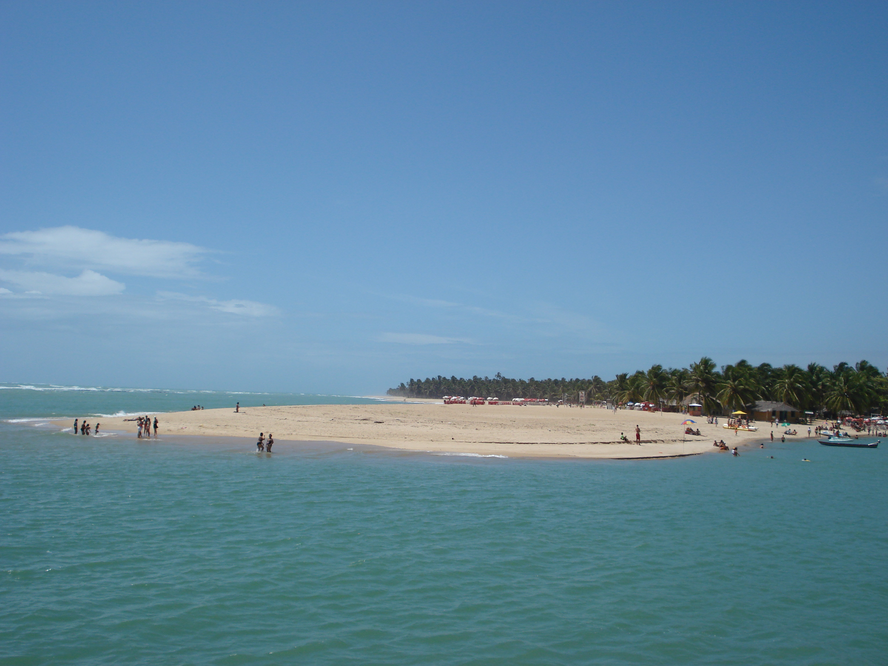
Alagoas, BR

Praia do Gunga

Praia-do-gunga-2012-09-22.JPG

Alagoas, BR

Praia do Gunga

By 2017, Gunga's 14 bar-restaurants, 18 food stalls and 32 craft stalls ran roughly 600 jobs, still pending the state's environmental sign-off.

Praia-do-gunga-2012-09-22.JPG · <a href="//commons.wikimedia.org/wiki/User:Lageandre" title="User:Lageandre">André Lage Freitas</a> · CC BY-SA 3.0
Nearest airport
MCZ · 41 km
I’m here for
Story

Praia do Gunga sits on a tongue of sand in Roteiro, a municipality of roughly 6,500 people on Alagoas' southern coast, where the Rio São Miguel widens into a tidal lagoon locally called the Lagoa do Roteiro before meeting the Atlantic. It belongs to Roteiro, not Barra de São Miguel across the water, though boats depart from Barra's marina. English Wikipedia files it under "Neighbourhoods in Maceió" — wrong; Gunga is about 43 km south of the capital by road.

Reaching it means water or land. Boats cross the lagoon from Barra de São Miguel in fifteen to twenty minutes; drivers arrive on a road that crosses private land, described simply as "by car driving through a private property" — there is no public through-road. From Zumbi dos Palmares Airport (MCZ), routing puts the drive at about 64 km, 68 minutes, farther than the 40.7 km straight-line map distance, since the coast road bends inland around the lagoon.

What greets arrivals is not empty coastline. By 2017 the beach ran a complex of 14 bar-restaurants, 18 food stalls and 32 craft stalls, per administrator Edinaldo Pulcino, drawing 5,000 monthly visitors at peak and employing roughly 600 people directly. On 7 July 2017 the state environmental institute (IMA/AL) and Roteiro's government began negotiating a Termo de Ajustamento de Conduta, Brazil's tool for legalizing a built operation, not approving one first. One of Alagoas' most-used tourism images sat on land whose paperwork trailed its economy.

The ecology keeps its own schedule. In January 2018 beachgoers found a broad-snouted caiman over two meters long on the sand, locally extinct in Alagoas for two decades before a breeding facility in Fernão Velho, Maceió, reestablished it. Eleven months later a stranded melon-headed whale died here despite a response from the Instituto Biota. The ocean side carries real surf, mean wave height 1.46 m, peaking near 1.8 m in June, and a rip current; the lagoon side is calm by geography.

None of this is staffed like a resort. There are no lifeguards; when a speedboat hit rocks nearby on 11 September 2017, injuring six, jangadeiros — raft fishermen — pulled the victims out. On 1 December 2018 a 60-year-old man drowned here; crews could not revive him. What's left is two beaches joined by a coconut-lined spit, running an economy still being formalized, on land reached by someone else's private road.

The spike

By 2017, Gunga's 14 bar-restaurants, 18 food stalls and 32 craft stalls ran roughly 600 jobs, still pending the state's environmental sign-off.

Praia do Gunga's fame is entirely visual: a coconut-lined sand spit where the Rio São Miguel's tidal lagoon meets the open Atlantic, the water reading bluer at low tide and greener at high tide as the two systems trade places. What that image leaves out is that the beach's actual tourist economy — the part that makes the postcard functional rather than theoretical — spent years running ahead of its own paperwork.

What was actually operating. By July 2017, according to complex administrator Edinaldo Pulcino, the beach supported 14 bar-restaurants, 18 food stalls and 32 craft stalls arranged in a dedicated pavilion. That is 64 individual commercial operations on a single sand spit in a municipality of about 6,500 people. Pulcino put monthly visitor traffic at roughly 5,000 in high season and 2,000 otherwise, and estimated the complex supported around 600 direct jobs and 3,000 indirect ones — a meaningful share of Roteiro's economy, running on a beach most outsiders encounter only as a photograph.

Why regularization, and why then. On 7 July 2017, Gustavo Lopes, director-president of Alagoas' state environmental institute (IMA/AL), met with Roteiro mayor Wladimir Brito and administrator Pulcino to begin drafting a Termo de Ajustamento de Conduta, a TAC. This is the standard Brazilian legal instrument for bringing an already-operating business or development into compliance with environmental law after the fact, rather than requiring compliance before construction. Brazil uses TACs constantly, precisely because so much commercial development along its coastline gets built first and licensed later, if at all. The framing of the 2017 meeting as "the first of several" meetings is itself informative: this was not a formality being rubber-stamped, but the opening move in a negotiation over how a functioning, job-supporting tourist complex would be brought into a compliance framework it had operated without.

The private road underneath the postcard. Gunga's access compounds the informality. There is no public road connecting the beach to the highway network; English-language reference sources describe car access simply as driving "through a private property." Visitors without a car cross the Lagoa do Roteiro by boat from Barra de São Miguel's marina instead, a fifteen-to-twenty-minute trip. Route-distance calculations bear out how indirect the land option is: a road trip from Zumbi dos Palmares International Airport runs about 64 kilometers and 68 minutes, well above the 40.7-kilometer straight-line distance a flat map would imply, because the coast road detours inland around the lagoon system before a final approach that isn't public right-of-way at all. Functionally, this means one of Alagoas' most reproduced tourism images sits on a peninsula where the state has negotiated environmental terms with the people running the kiosks, while the physical route to get there by land runs through the Fazenda Gunga — land the Ministério Público Federal's own 9 May 2017 recommendation names as controlled by ex-mayor Nivaldo Jatobá and his company, Nivaldo Jatobá – Empreendimentos Agroindustriais LTDA, not the state. The 2025 TAC's own recitals note there is no roadside parking on that access road, so arriving by car in practice means paying the complex's parking fee; anyone unwilling or unable to pay it is effectively shut out. Two separate kinds of informal governance sit on top of each other: commercial and territorial.

The ecology arrived on its own terms too. The peninsula's wildlife punctuates this story rather than illustrating it directly, but the pattern rhymes. In January 2018, bathers found a two-meter broad-snouted caiman (Caiman latirostris) on the sand. The species had been locally extinct in Alagoas for roughly two decades; a captive-breeding facility in Maceió's Fernão Velho neighborhood reestablished a wild population, and rising water in inland lagoons during the breeding season periodically pushes individuals toward the coast, Gunga's lagoon included. Eleven months later, a stranded melon-headed whale died on the beach despite intervention from the Instituto Biota. Both events are reminders that the lagoon-and-ocean geography that makes Gunga scenic also makes it a live ecological corridor, not a static backdrop.

And nobody is watching the water. The complex has no lifeguard service. When a speedboat lost power and struck rocks near the beach on 11 September 2017, injuring six people including two children, it was jangadeiros, independent traditional raft fishermen working the area, who performed the rescue, not any official emergency service. On 1 December 2018, a 60-year-old man drowned here; fire, ambulance and helicopter units responded but could not revive him. The ocean side of the peninsula carries a real, dataset-flagged rip current and an annual mean wave height of 1.46 meters, rising toward 1.8 meters in June — conditions that exist regardless of how informally the beach around them is run.

What actually singular about Gunga, then, isn't the color-changing water. Plenty of estuary-mouth beaches shift color with the tide. What is specific to this one is the gap between how it is marketed and how it is governed: a photogenic sand spit that, for years, ran a 64-stall, thousands-of-jobs tourist economy on land it reached through someone else's driveway, while its operator repeatedly failed to meet the terms the state set for it. IMA issued 27 infraction notices on 1 July 2017; a first TAC, TAC/COJ nº 94/2017, was signed with the operator on 28 August 2017; in March 2024 IMA cancelled that TAC outright, citing total non-compliance — no sewage-treatment plant, no solid-waste system, no urban plan, no environmental-education project — and embargoed part of the complex the following month. After a 10 June 2024 meeting between the Ministério Público Federal, IMA/AL and the complex, a second TAC was signed on 10 April 2025: it gives the operator 30 days to file sewage-treatment, hydro-sanitary, architectural, solid-waste-collection, IPHAN and SPU documentation, after which IMA has 60 days to assess it before deciding whether to issue an operating licence, and it requires at least 20% of the complex's lower parking lot to be kept free for reduced-mobility access. As of April 2025, then, the operator had a fresh filing deadline, not a finished permit — whether IMA has since issued an operating licence isn't documented here.

A fazenda de coqueiros e o mar.JPG
Culture

Where it shows up

Other
  • "One of the most beautiful beaches in Brazil" · 2016

    English Wikipedia sources this characterization to a 2016 Brazilian travel-blog post (Viajante Comum), not any ranking body, though the phrase recurs widely across tourism material.

  • "Natural aquarium" boat-trip branding

    Tour operators market shallow-water boat trips from Gunga as visits to a "natural aquarium," a nickname repeated in English-language reference material on the beach.

History
  • Zumbi dos Palmares International Airport

    Gunga's gateway airport in Maceió is named for Zumbi, leader of the 17th-century Quilombo dos Palmares maroon settlement in inland Alagoas — a historical reference point for the region, not for the beach itself.

Praia do Gunga 140.jpg
History

What happened here

  1. 1963founding

    Roteiro becomes its own municipality

    Roteiro, the municipality containing Praia do Gunga, is created on 18 December 1963, separating its administration from neighboring Barra de São Miguel and Marechal Deodoro.

    Wikipedia →
  2. 2017policy

    IMA and Roteiro open regularization talks for the beach complex

    On 7 July 2017, IMA/AL director-president Gustavo Lopes and Roteiro mayor Wladimir Brito meet with complex administrator Edinaldo Pulcino to begin drafting a Termo de Ajustamento de Conduta covering the beach's 14 bar-restaurants, 18 food stalls and 32 craft stalls, described as the first of several planned meetings.

  3. 2017policy

    IMA issues 27 infraction notices to the beach complex

    On 1 July 2017 the state environmental institute IMA/AL issues 27 autos de infração against the commercial complex on the peninsula, the enforcement step that precedes the regularization talks opened a week later.

  4. 2017policy

    First TAC (TAC/COJ nº 94/2017) signed with the operator

    On 28 August 2017 IMA/AL and the complex's operator formalize TAC/COJ nº 94/2017, the conduct-adjustment agreement meant to bring sewage treatment, solid-waste handling and licensing into compliance.

  5. 2017incident

    Speedboat hits rocks near the beach

    On 11 September 2017, a speedboat traveling from Barra de São Miguel to Maceió loses engine power at high speed and strikes rocks near Praia do Gunga, injuring six people including two children aged 10 and 12; nearby jangadeiros perform the rescue before the Capitania dos Portos investigates.

  6. 2018natural

    Broad-snouted caiman found on the beach

    On 24 January 2018, a Caiman latirostris up to two meters long is found by bathers and rescued by the Environmental Police Battalion; the species had been locally extinct in Alagoas for about two decades before a Fernão Velho breeding facility helped reestablish it.

  7. 2018incident

    60-year-old man drowns

    On 1 December 2018, José Raimundo, 60, drowns at Praia do Gunga; Fire Department, SAMU ambulance and the Falcão 5 aerial unit attempt resuscitation without success, and the cause of the drowning is not established in reporting.

  8. 2018natural

    Melon-headed whale strands and dies

    On 28 December 2018, a female melon-headed whale over two meters long strands in shallow water; Instituto Biota responds but the animal dies by early afternoon, and a necropsy is ordered to determine the cause.

  9. 2019incident

    16-year-old tourist drowns

    On 13 January 2019, a 16-year-old tourist from Sergipe drowns at Praia do Gunga after roughly 40 minutes submerged; local jangadeiros and a helicopter take part in the rescue effort.

  10. 2019incident

    Unidentified body recovered near the lagoon mouth

    On 12-13 March 2019, fishermen find a woman's body floating near the Boca da Barra, close to Praia do Gunga; Polícia Militar, Corpo de Bombeiros, the Instituto de Criminalística and the Instituto Médico Legal respond, and the case remains unresolved in available reporting.

  11. 2024policy

    IMA cancels the 2017 TAC for total non-compliance

    In March 2024 IMA/AL notifies the Ministério Público Federal that it has cancelled TAC/COJ nº 94/2017 'em razão do seu descumprimento integral' — none of the agreed works had been delivered.

  12. 2024policy

    Embargo on the complex

    On 11 April 2024 IMA/AL embargoes the commercial complex, the enforcement action that follows the cancelled agreement.

  13. 2024policy

    MPF, IMA and the complex meet

    On 10 June 2024 the Ministério Público Federal, IMA/AL and the complex's operator meet to negotiate a replacement agreement.

  14. 2025policy

    Second TAC signed; 30-day filing deadline, no operating licence yet

    On 10 April 2025 the MPF and IMA/AL sign TAC nº 2/PR/AL with the operator: 30 days to file sewage-treatment, hydro-sanitary, architectural, solid-waste, IPHAN and SPU documents, after which IMA would evaluate a licence. As of that date the operator held a deadline, not a permit.

The honest part
“One of Alagoas' most-used tourism images sat on land whose paperwork trailed its economy.”

Praia do Gunga is marketed as one of Brazil's most beautiful beaches, a claim English Wikipedia itself traces to a single 2016 travel-blog post rather than any ranking body. What that marketing leaves out is that the beach has no lifeguard service, no public road, and a commercial complex whose environmental paperwork is still open eight years on: IMA issued 27 infraction notices in 2017, signed a first TAC with the operator that August, cancelled it outright in March 2024 for total non-compliance, and embargoed its mirante restaurant, an under-construction pousada and its artisan stand that April. A second, signed Termo de Ajustamento de Conduta followed with the Ministério Público Federal and IMA/AL on 10 April 2025 — one that gives the operator 30 days to file sewage-treatment, hydro-sanitary, architectural, solid-waste-collection, IPHAN and SPU documentation and requires at least 20% of the complex's lower parking lot to be kept free for reduced-mobility access, with the 2024 embargoes to be released only as IMA clears that documentation and, potentially, issues an operating licence. Access runs through a private property by land or a fifteen-to-twenty-minute boat crossing by water; rescue after the 2017 speedboat accident that injured six people came from jangadeiros, not any official service; and a 16-year-old tourist drowned here on 13 January 2019 after roughly 40 minutes submerged, despite a rescue effort that included local jangadeiros and a helicopter.

None of that makes Gunga exceptional among Brazilian ocean beaches without formal safety infrastructure — it makes it representative of one. What is unusual is the gap between the image and the governance: a peninsula reused constantly in Alagoas tourism marketing whose actual commercial engine, 14 bar-restaurants, 18 food stalls, 32 craft stalls and an estimated 600 direct jobs as counted in 2017, ran for years on unresolved environmental terms, burned through one TAC entirely, and in April 2025 signed a second that sets a fresh 30-day filing deadline rather than closing the matter — terms that reserve a fifth of the complex's lower parking lot for free, reduced-mobility access, not a general public guarantee of free beach access; the Ministério Público Federal had already recommended free access to the beach back in May 2017, without result. Local press covering this same TAC (Alagoas 24 Horas, April 2025) described the parking clause more broadly, as a free-public-access guarantee rather than a reduced-mobility-specific one; the TAC's own wording, cited above, is narrower.

Barra de São Miguel & Praia do Gunga.jpg
Anatomy

The shape of the place

Lagoa do Roteiro shore

40%

The calmer, estuary-facing side where the Rio São Miguel widens into the Lagoa do Roteiro before the ocean; shallow, tide-exposed sand flats form here at low water.

Best for Calmer swimming, children, low-tide pool wading

Boats from Barra de São Miguel's marina land on this side.

Beach complex (kiosk pavilion)

50%

The commercial core of the peninsula: 14 bar-restaurants, 18 food stalls and 32 craft stalls as counted in 2017, still working through formal state environmental permitting at that count.

Best for Food, drink and craft shopping

Subject of the 2017 IMA/Roteiro Termo de Ajustamento de Conduta talks.

Coconut-lined sand spit

50%

The narrow strip of coconut palms running the length of the peninsula, the composition behind most of Gunga's circulated photographs and the physical divider between ocean and lagoon.

Best for Photography, walking between the two shores

Falling coconuts are a real, if minor, hazard under wind.

Atlantic-facing shore

60%

The exposed Atlantic side of the spit, carrying the real surf and rip current flagged in the local wave dataset (annual mean 1.46 m, peak-day 2.2 m).

Best for Surf-aware swimming and photography of open Atlantic swell

No lifeguard service; the 2018 drowning occurred on this side of the peninsula.

Landmarks

Marina de Barra de São Miguel

marina

The departure point for boats crossing the Lagoa do Roteiro to Praia do Gunga; most visitors without a car reach the beach from here.

Wikipedia →

Complexo da Praia do Gunga

commercial complex

The 14-bar-restaurant, 18-food-stall, 32-craft-stall commercial pavilion on the peninsula, subject of the 2017 IMA/Roteiro environmental regularization talks.

A day here

From first light to dark

Dawn

The tide, not the light, sets the geography before the complex opens: at low water the sand flats on the lagoon side are exposed, and the first boats cross from Barra de São Miguel's marina before the day's onshore wind builds.

Midday

The ocean side shows what the wave data promises, a mean height near 1.2-1.8 m depending on season and a rip current worth respecting, while the lagoon side stays flat; the complex's 14 bar-restaurants and 18 food stalls are at full trade.

Golden hour

Late light favors the coconut-lined spit itself, the composition behind most of Gunga's circulated photographs; boat traffic back toward Barra de São Miguel's marina picks up as day-trippers time the crossing to the fading light.

Night

After the complex closes there is no lit boardwalk and no official presence; the peninsula that supported an estimated 600 direct jobs by day reverts, after dark, to an unlit spit between a lagoon and open ocean.

A rede das redes (12204061944).jpg
Sea & surf

What the water does

JFMAMJJASONDmetres (significant wave height)

Solid = typical monthly wave height; pale = the bigger days (90th pct). Offshore/regional swell from Open-Meteo Marine (ERA5 Ocean reanalysis, 2023–2024); a sheltered cove may sit calmer than this.

Exposed — real surf, and rip current to respect
Typical wave height
1.46 m
Biggest swell
Jun · 1.8 m
Calmest
Feb · 1.18 m
Typical period
8.4 s (groundswell)
Before you go

Things to know

Getting there is a choice, not a road

There's no public road all the way in. Cross by boat from Barra de São Miguel's marina (roughly 15-20 minutes) or arrive by a route that crosses private property; confirm which one your trip actually uses before booking.

No lifeguards

Recorded rescues here, a 2017 speedboat crash and a 2018 drowning, were handled by jangadeiros or emergency services called in after the fact, not by any lifeguard stationed on the beach.

Pick your side

The Atlantic side carries real surf and a rip current, per the site's wave dataset; the Lagoa do Roteiro side is calm and shallow, and it's the side to choose for children or weak swimmers.

The complex runs on cash and informality

As of the 2017 IMA/Roteiro talks, the beach's 14 bar-restaurants, 18 food stalls and 32 craft stalls were still working through formal environmental permitting; treat it as an informal market, not a regulated resort strip.

Surf & rip

Powerful water — strongest around Jun, gentlest in Feb. Mind rip currents; this isn't a wade-in-anywhere beach.

Sharks

No incidents on record in the global shark-attack file.

Plan

If you go

Getting there
Nearest airport
Zumbi dos Palmares International Airport (MCZ) · 41 km
Nearest town
Marechal Deodoro · 17 km

Praia do Gunga sits in Roteiro municipality on the Alagoas coast south of Maceió. Most visitors cross the Lagoa do Roteiro by boat from Barra de São Miguel's marina, about 15-20 minutes each way; the only road route crosses private land, with no public through-road. By road, the beach is roughly 43 km (about 44 minutes) from central Maceió and about 64 km (about 68 minutes) from Zumbi dos Palmares International Airport (MCZ) — both routing-engine estimates, and both notably longer than straight-line map distance because the coast road detours around the lagoon system.

When to go
  • Low-tide natural pool window · Twice daily, tied to the tide cycle

    The shallow, swimmable pools that form on Gunga's exposed sand flats are a tidal event, not a calendar one — they appear and vanish with each low tide rather than on any fixed festival schedule.

What to eat & drink
Grilled and fried fresh fish

The standard order at Alagoas' southern-coast beach kiosks; Roteiro's 2017 count of 18 food stalls at Gunga is the verified scale of this trade, though no individual stall names are documented in available sources.

The kiosk pavilion within the Gunga beach complex

Água de coco (coconut water)

Served straight from the palms that line the peninsula, the standard cold drink at any Alagoas beach and one this particular stretch is specifically known for, given its coconut canopy.

Vendors throughout the beach complex

Camarão (shrimp) plates

Of the complex's 14 bar-restaurants, shrimp dishes are a standard order on Alagoas' southern coast, typically served with rice and farofa; individual restaurant names are not independently documented in available sources.

The complex's bar-restaurants

Barra de São Miguel harbor restaurants

The wider dining scene most visitors actually rely on sits across the lagoon in Barra de São Miguel proper, where the town's marina and streets support a larger, more varied restaurant scene than the beach complex itself.

Barra de São Miguel, across the Lagoa do Roteiro

Sources & references
  1. TAC nº 2/PR/AL (MPF/IMA-AL, 10 Apr 2025), recitals · cited 5×
  2. GazetaWeb, 7 Jul 2017 · cited 3×
  3. Wikipedia: Roteiro, Alagoas · cited 2×
  4. GazetaWeb, 24 Jan 2018 · cited 2×
  5. GazetaWeb, 11 Sep 2017
  6. GazetaWeb, 1 Dec 2018
  7. GazetaWeb, 28 Dec 2018
  8. Alagoas 24 Horas, 13 Jan 2019
  9. GazetaWeb, 12 Mar 2019
  10. Folha de Alagoas, 13 Jun 2024
  11. OSRM routing engine (car profile)
  12. OSRM routing engine; beach dataset
  13. GazetaWeb, 7 Jul 2017 (admin. Edinaldo Pulcino)
  14. Open-Meteo Marine ERA5 reanalysis, 2023-2024
Colophon · Provenance

Where this page comes from

Geography, facilities
OpenStreetMap (ODbL) for geometry and facility tags within 500 m of the beach centroid. GeoNames for city/airport distances.
Climate & ocean
Open-Meteo ERA5 + Marine archive, 2014–2023 monthly normals.
Photography
Archival, original tone (Tier B — Wikimedia Commons). Each image licensed per its own terms; attribution visible inline.
History & culture
Every factual claim is linked to its source in the prose above. Wikipedia citations inline. Non-wiki sources named where relevant.
Editorial voice
Register: wry. Written to pass a local's nod test; corrections welcome.
Written by Erin Rose
Last reviewed 2026-04-19
v0.9 — in editorial development toward v1.0