South Aegean, GR

Sarakiniko Beach

Sarakshape.JPG

South Aegean, GR

Sarakiniko

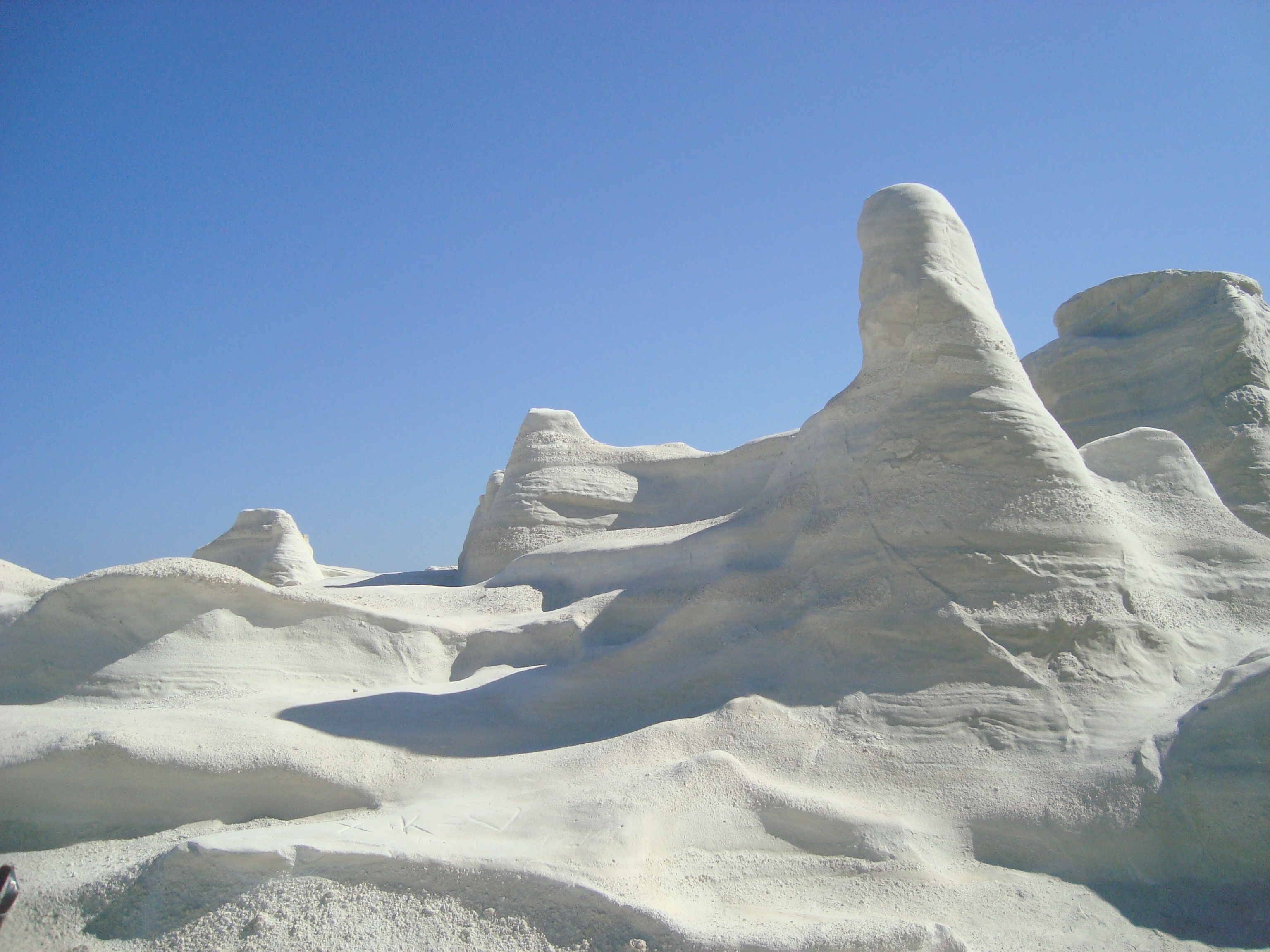
Wind off the Aegean and waves driven by the north winds have eroded Milos's pale volcanic tuff into a bare, treeless lunar landscape with no soil and no shade.

Sarakshape.JPG · <a href="//commons.wikimedia.org/w/index.php?title=User:Vihou_World&amp;action=edit&amp;redlink=1" class="new" title="User:Vihou World (page does not exist)">Vihou World</a> · CC BY-SA 4.0
Nearest airport
JTR · 99 km
Tier
Featured
I’m here for
Story

Sarakiniko sits on the north shore of Milos, a volcanic island in the South Aegean about 2.2 kilometers from the port town of Adamas. There is almost no sand and almost no green. The ground is greyish-white volcanic rock, soft enough that wind off the open sea and waves driven by the north winds have worn it into bare, rounded curves with no soil to hold a plant. A couple of trees at the back of the inlet supply the only shade on the whole site. The result is a treeless expanse most people describe as a moonscape, and it is one of the most photographed landscapes in the Aegean.

The rock is the record of Milos's volcanism. The island is volcanic in origin, with activity that began two to three million years ago in the Pliocene and last erupted roughly 90,000 years ago. Sarakiniko's pale tuff and pumice are the compacted ash of those eruptions, and their bone-white color is what the wind and waves expose as they strip the surface. The same erosion has cut a narrow inlet of thin white sand niched between the rock formations, where the water is calm enough to swim when the meltemi is down.

The site has no facilities. No taverna, no lifeguard, no fresh water, no umbrellas, and access is free. The rock is sharp underfoot and slick when wet, and the inlet shelves into deeper water where swimmers and visitors jump from the low cliffs into the sea. On the eastern, desert side of the headland lies the wreck of the Africa, a ship that ran aground at Sarakiniko in 2003 and shows above the surface when the waves draw back.

Milos has a long human record under the same volcanic geology. Its obsidian was traded across the Aegean and the Near East as early as 15,000 years ago, worked into blades long before farming; the Bronze Age town of Phylakopi, excavated in 1896 and again in 1973 by Colin Renfrew, stood on the island's northeast coast. The island has been mined for sulphur, bentonite, perlite, pozzolana, and kaolin into the modern era. In 1820 a farmer on Milos uncovered the Parian-marble statue now called the Venus de Milo, in the Louvre since 1821 — island context, not a Sarakiniko find.

The spike

Wind off the Aegean and waves driven by the north winds have eroded Milos's pale volcanic tuff into a bare, treeless lunar landscape with no soil and no shade.

Most famous beaches earn their fame from sand, water color, or a single landmark. Sarakiniko's defining fact is the absence of all the usual beach material: there is almost no sand, no soil, and no vegetation beyond two trees. What is left is bare rock, and the bare rock is the whole point.

What the rock is. Milos is a volcanic island. Its volcanism began two to three million years ago in the Pliocene and last erupted about 90,000 years ago, and across that span it laid down thick beds of ash and pumice that compacted into pale tuff. Sarakiniko is a headland of that tuff on the island's north shore. The rock is soft — soft enough to scratch, soft enough to crumble — and greyish-white where it is fresh.

What the wind and sea did to it. Sarakiniko faces the open Aegean and the north winds that drive the waves onto Milos's north coast. Soft volcanic tuff exposed to that wind and water erodes fast and erodes smoothly, without the fracturing of harder rock. The result is a surface of rounded, scoured curves rather than jagged cliffs — bone-white where the weathering has stripped it, with a narrow inlet of thin white sand cut between the formations. There is no soil left to hold a plant, which is why the headland is treeless, and the treelessness is what completes the effect.

Why people call it the moon. Bare pale rock, eroded into smooth swells, with no green to read as Earth, photographs as a lunar surface. The comparison is so consistent that Sarakiniko is routinely called the Moon Beach or a lunar landscape, and it is one of the most photographed coastal landscapes in the Aegean. The image is graphically legible — white rock, deep blue water, hard light — and that legibility is what carries it across travel media.

The honest condition of the place. The same facts that make the spike make the discomfort. No soil means no shade and no relief from the sun reflecting off the white rock. Soft rock means sharp edges underfoot and surfaces that turn slick when wet. An exposed headland means the meltemi can turn the calm inlet choppy in an afternoon. Visitors jump from the low cliffs into water whose depth is unmarked, with no lifeguard present. On the eastern, desert side of the headland the wreck of the Africa, aground since 2003, surfaces when the waves draw back — a reminder that this is an exposed north coast, not a sheltered bay. Sarakiniko delivers exactly one thing at full strength: eroded white volcanic rock against the sea. Everything a beach usually provides, it withholds.

Sar004.jpg
Culture

Where it shows up

Other
  • The Moon Beach / lunar landscape

    Sarakiniko is widely described as a moonscape or lunar landscape because its bare white eroded rock resembles the surface of the moon. The comparison drives much of the photography that makes it one of the most photographed landscapes in the Aegean.

History
  • Milos obsidian and the prehistoric Aegean trade

    Milos was one of the prehistoric Mediterranean's principal obsidian sources, its volcanic glass worked into blades and traded across the Aegean and Near East as early as 15,000 years ago, long before farming. The same volcanism produced Sarakiniko's rock.

  • The Venus de Milo · 1820

    The Parian-marble statue found by a farmer on Milos on 8 April 1820, dated to the 2nd century BC and in the Louvre since 1821. It is island context for Milos, not a find from Sarakiniko itself.

Sbea.JPG
History

What happened here

  1. -3000000natural

    Milos volcanism begins

    Volcanic activity on Milos begins roughly two to three million years ago in the Pliocene epoch. The ash and pumice it deposits become the pale tuff later exposed at Sarakiniko.

    Wikipedia →
  2. -90000natural

    Last eruption on Milos

    The island's volcanism last erupts about 90,000 years ago. The volcanic rock left behind is the soft greyish-white material that wind and waves later erode into Sarakiniko's formations.

    Wikipedia →
  3. -13000cultural

    Milos obsidian trade

    Obsidian from Milos is traded across the Aegean and the Near East as early as about 15,000 years ago, worked into sharp blades long before farming. The island becomes one of the prehistoric Mediterranean's major obsidian sources.

    Wikipedia →
  4. 1820cultural

    Venus de Milo found on Milos

    On 8 April 1820 a farmer on Milos uncovers the Parian-marble statue now known as the Venus de Milo, dated to the 2nd century BC. It is taken to France and has been in the Louvre since 1821. The find is island context, not a Sarakiniko discovery.

    Wikipedia →
  5. 1896cultural

    Phylakopi first excavated

    The Bronze Age town of Phylakopi, on the northeast coast of Milos, is first excavated by the British School at Athens in 1896, with further work in 1973 by Colin Renfrew. It documents the island's deep prehistoric occupation.

    Wikipedia →
  6. 2003disaster

    The Africa runs aground

    A ship named the Africa crashes at Sarakiniko in 2003. The wreck lies on the eastern, desert side of the headland and shows above the surface when the waves retreat.

    Wikipedia →
The honest part
Sarakiniko delivers exactly one thing at full strength: eroded white volcanic rock against the sea. Everything a beach usually provides, it withholds.

Sarakiniko gives you the rock and the water and nothing else. There is no shade beyond two trees at the back of the inlet, no fresh water, no lifeguard, and no taverna; the nearest cafe is in Adamas, a few minutes' drive away. The bare white tuff that makes the place reflects the Aegean sun back at you with no relief, and in July and August the small free parking area fills by mid-morning. The rock is sharp and turns slick where it is wet, and people routinely jump from the low cliffs into water they have not checked. None of this is hidden danger — it is the plain condition of an exposed volcanic headland with no infrastructure, photographed so heavily that the crowds arrive expecting a beach and find a rock shelf instead. Come early or late, bring your own water and footwear, and treat the cliff jumps as the unmanaged risk they are.

Sar003.jpg
Anatomy

The shape of the place

The swimming inlet

50%

The narrow cut of thin white sand niched between the rock formations, where the water is calm enough to swim when the north wind is down. The only patch of sand on an otherwise bare rock headland.

Best for Swimming and entering the water

Sharp rock at the edges; no lifeguard. Calm in still weather, choppy when the meltemi blows.

The eroded white rock

50%

The bare greyish-white volcanic tuff worn by wind and waves into rounded, treeless curves, the formation that gives Sarakiniko its lunar nickname. No soil, no shade, no vegetation.

Best for Walking the formations and photography

Rock is sharp underfoot and slick when wet; wear grippy footwear.

The cliff-jump ledges

60%

Low cliffs around the inlet where swimmers and visitors jump into the deeper water off the rock. The drop and water depth are unmarked and unmanaged.

Best for Cliff jumping for confident swimmers

No lifeguard; check depth and conditions before jumping. An unmanaged risk.

The Africa wreck (east side)

90%

The remains of the ship Africa, which ran aground at Sarakiniko in 2003, lying on the eastern desert side of the headland and visible above water when the waves draw back.

On the far eastern side away from the main inlet; appears at low water.

Landmarks

Sarakiniko volcanic rock formations

natural

The greyish-white tuff and pumice of Milos, eroded by wind and north-wind-driven waves into a bare, treeless landscape on the island's north shore. Compacted ash from volcanism that began two to three million years ago and last erupted about 90,000 years ago.

Wikipedia →

Wreck of the Africa

shipwreck

A ship that ran aground at Sarakiniko in 2003. Its remains lie on the eastern, desert side of the headland and are visible above the surface when the waves retreat.

Wikipedia →
A day here

From first light to dark

Dawn

At first light the white rock is grey and the inlet is in shadow, the meltemi often still. The small parking lot is nearly empty; the few people present are photographers working the low sun across the eroded curves before the glare flattens them.

Midday

By late morning the sun is overhead and the bare tuff throws the light straight back with no shade to break it. The free lot is full, the narrow inlet of white sand is crowded, and visitors jump from the low cliffs into the deeper water off the rock.

Golden hour

Late afternoon rakes warm light across the white formations and the crowds thin as the day-trippers head back toward Adamas. The rock holds the last sun after the inlet falls into shadow, the hour photographers favor over the hard noon.

Night

After dark Sarakiniko is unlit and empty, with no facilities and no one staying. The exposed headland, treeless and pale, is one of the darker spots near Adamas for the stars over the open Aegean.

Sarakiniko beach.jpg
Sea & surf

What the water does

JFMAMJJASONDmetres (significant wave height)

Solid = typical monthly wave height; pale = the bigger days (90th pct). Offshore/regional swell from Open-Meteo Marine (ERA5 Ocean reanalysis, 2023–2024); a sheltered cove may sit calmer than this.

Mixed — usually swimmable, with a livelier season
Typical wave height
1.05 m
Biggest swell
Jan · 1.46 m
Calmest
Jun · 0.68 m
Typical period
5 s (wind chop)
Before you go

Things to know

No shade or facilities

Two trees at the back of the inlet are the only shade; there is no taverna, fresh water, lifeguard, or umbrellas. Bring water, sun protection, and food.

Sharp rock

The volcanic rock is sharp underfoot and slick when wet. Wear grippy water shoes or sandals; many visitors arrive barefoot and regret it.

Cliff jumping

Visitors jump from the low cliffs into the sea off the rock. There is no lifeguard and the depth is unmarked; check the water before jumping.

Arrive early

The small free parking area fills by mid-morning in July and August. Arrive early or late in the day for parking and lighter crowds.

Wind

The headland is exposed; the meltemi north wind makes the inlet choppy and the swimming rougher. Calmer in still weather.

Sharks

No incidents on record in the global shark-attack file.

Plan

If you go

Getting there
Nearest airport
Santorini International Airport (JTR) · 99 km
Nearest town
Adamas · 2 km

Sarakiniko is about 2.2 kilometers from Adamas, the main port of Milos, a 5-to-10-minute drive on paved road. Access is free with a small free parking area that fills by mid-morning in summer; the headland is also reached by water taxi and boat in season.

What to eat & drink
Nothing on site

Sarakiniko has no taverna, kiosk, or fresh water, and only two trees of shade. Eat and drink before you arrive or after you leave, and carry your own water; the exposed white rock offers no relief from the sun.

Plan around the headland, not on it

Adamas waterfront tavernas

The island's main port, about 2.2 kilometers from Sarakiniko, has the nearest concentration of tavernas, supermarkets, and cafes. The standard Greek-island meal of grilled fish, souvlaki, and local oil is served along the harbor.

Adamas, the port town nearest the beach

Milos cheeses and local produce

Milos produces island cheeses and farm goods sold in Adamas, Plaka, and the inland villages. These are regional staples rather than tourist inventions, found in shops and on meze plates across the island.

Adamas and the villages of Milos

Sources & references
  1. Wikipedia: Milos · cited 5×
  2. Wikipedia: Sarakiniko Beach · cited 5×
  3. Wikipedia: Venus de Milo
  4. Wikipedia: Milos; Phylakopi
  5. Wikipedia: Sarakiniko Beach; Milos
  6. World Beach Tour beach data
Colophon · Provenance

Where this page comes from

Geography, facilities
OpenStreetMap (ODbL) for geometry and facility tags within 500 m of the beach centroid. GeoNames for city/airport distances.
Climate & ocean
Open-Meteo ERA5 + Marine archive, 2014–2023 monthly normals.
Photography
Archival, original tone (Tier B — Wikimedia Commons). Each image licensed per its own terms; attribution visible inline.
History & culture
Every factual claim is linked to its source in the prose above. Wikipedia citations inline. Non-wiki sources named where relevant.
Editorial voice
Register: severe. Written to pass a local's nod test; corrections welcome.
Written by Erin Rose
Last reviewed 2026-04-19
v0.9in editorial development toward v1.0