Lower Normandy, FR

Sword Beach

The Blue Marble, AS17-148-22727.jpg

Lower Normandy, FR

Sword Beach

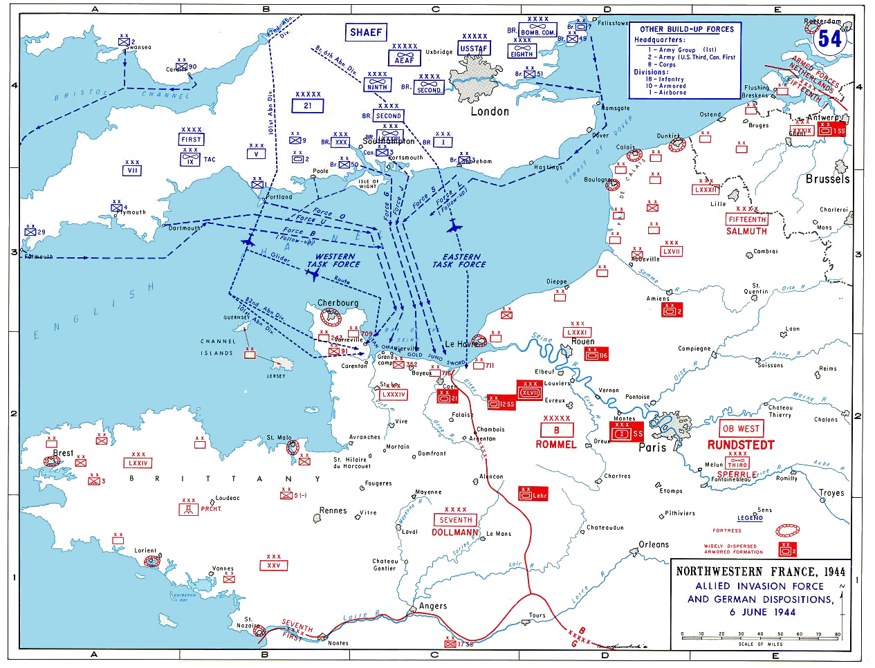
The easternmost D-Day beach, where the British 3rd Division landed to reach the Pegasus Bridge gliders and take Caen — Caen held for a month.

The Blue Marble, AS17-148-22727.jpg · Harrison Schmitt / Apollo 17 · Public domain
Length
700 m
Spring tide
6.53 m
Nearest airport
CFR · 17 km
Tier
Featured
I’m here for
Story

Sword Beach is the easternmost of the five Allied landing beaches of 6 June 1944, an arc of roughly 8 kilometers on the Calvados coast of Normandy from Ouistreham, at the mouth of the Orne and the Caen canal, west toward Saint-Aubin-sur-Mer. The name is not French — it was the codename Allied planners gave the sector, and like Omaha, Utah, Gold, and Juno it has outlived the operation and entered ordinary use. The beach fronts a line of small communes: Ouistreham and its Riva-Bella seafront at the east end, then Colleville-Montgomery, Hermanville-sur-Mer and its La Brèche access, Lion-sur-Mer, and Luc-sur-Mer.

The assault here was the left flank of the whole invasion, and its job was specific. The British 3rd Infantry Division, under Major General Tom Rennie, came ashore from 7:25 a.m. with the 13th/18th Royal Hussars' amphibious tanks, ordered to drive 14 kilometers inland and take Caen on the first day. On its eastern edge the landing was tied to the airborne operation that had begun just after midnight: Major John Howard's glider-borne company of the Ox and Bucks had seized the bridges over the Caen canal and the Orne at Bénouville and Ranville in the first minutes of D-Day, and the men off Sword had to reach them. Lord Lovat's 1st Special Service Brigade — with Philippe Kieffer's French commandos and Lovat's piper Bill Millin — pushed inland to do exactly that, reaching the bridges around midday.

The day did not finish what it started. The 3rd Division got men and tanks ashore and linked up with the airborne, but the advance on Caen stalled — halted by the only major German armoured counter-attack of the day, by the 21st Panzer Division, whose forward elements reached the coast in the Sword–Juno gap near Lion-sur-Mer by 20:00. Caen, the first-day objective, would not fall for another month, and then only as a ruin. The division's casualties on Sword for 6 June are usually given around 630, though a unit-by-unit tally comes closer to 683; sources differ and the count is an estimate. About 28,845 men had come ashore here by nightfall.

What sits on that sand now is a working seafront, less visited and less filmed than Omaha. Ouistreham is a cross-Channel ferry port with sailings to Portsmouth, Riva-Bella has a casino on the ground where a German strongpoint stood, and in summer the promenades fill on a wide, gently shelving beach with a 6.5-meter spring tide. The memory is held in fixed points: the Grand Bunker, a 17-meter German fire-control tower at Ouistreham now run as the Atlantic Wall Museum; the bronze statue of Bill Millin on the dunes; the divisional and commando memorials; and the bridges up the Orne that the men from this beach raced to reach. It was a resort coast that became the hinge between the seaborne and airborne halves of the invasion's eastern flank, and the honest reading holds the ferry terminal, the holiday seafront, and the unmet objective of Caen on one line of coast.

The spike

The easternmost D-Day beach, where the British 3rd Division landed to reach the Pegasus Bridge gliders and take Caen — Caen held for a month.

Most legendary beaches earn the word from nature — a reef, a wave, a color of sand. Sword earned it as a hinge: it was the easternmost beach of the invasion, the left edge of the whole Allied line on 6 June 1944, and its singular role was to join the two halves of that flank — the men who came by sea and the men who came by air — and then drive inland to take Caen on the first day. It managed the join. It failed the drive. That gap between what Sword achieved by lunchtime and what it was ordered to achieve by nightfall is the thing worth standing on the beach to understand.

Start with the eastern edge, because the airborne operation that frames Sword began before the beach landings did. Just after midnight — the gliders touched down at about 00:16 — Major John Howard's reinforced company of the 2nd Oxfordshire and Buckinghamshire Light Infantry, carried in six Horsa gliders, landed almost on top of the bridges over the Caen canal at Bénouville and the river Orne at Ranville. This was Operation Deadstick, a coup de main, and it was one of the most precise actions of the entire invasion: the lead gliders stopped within yards of their targets and the bridges were taken intact in a short, sharp fight. The canal bridge was later renamed Pegasus Bridge for the winged-horse badge of the 6th Airborne Division, and the Café Gondrée beside it bills itself as the first house in France liberated on D-Day. Holding those bridges intact mattered because they were the only crossings of the Orne and its canal on the eastern flank; keeping them denied the Germans an easy route to roll up the invasion from the east, and gave the Allies their own route to reinforce the airborne bridgehead. But the lightly armed paratroopers and glider troops could not hold indefinitely against armour. Someone had to reach them from the sea. That someone landed on Sword.

Now the beach itself. The British 3rd Infantry Division, commanded by Major General Tom Rennie, assaulted Sword on a narrow front beginning at 7:25 a.m., the swimming DD tanks of the 13th/18th Royal Hussars going in roughly with the leading infantry of the 8th Infantry Brigade — the South Lancashires and East Yorkshires. The principal beach strongpoint, codenamed "Cod," stood at La Brèche d'Hermanville on the Queen White sector and had to be reduced in the first hour at real cost. By later D-Day standards Sword was not a slaughter on the scale of Omaha: the surf and the strongpoints were deadly in the first wave, but the beach was largely cleared and the follow-on brigades came ashore through the morning. At the eastern end, the French troop of Free French commandos under Philippe Kieffer, attached to Lord Lovat's brigade, fought through Ouistreham and Riva-Bella and reduced the fortified casino position there shortly after 9 a.m. — Frenchmen liberating French soil on the first morning, a fact the Ouistreham memorials keep front and center.

The link-up is the part that worked, and it is the reason to call Sword a hinge. Lord Lovat's 1st Special Service Brigade pushed off the beach and inland toward the Orne bridges, his personal piper Bill Millin playing the bagpipes as they went — the War Office had banned pipers from leading men into action after the First World War, but Lovat, a Highlander, told Millin the ban was an English regulation that did not apply to two Scots. German snipers later said they did not shoot the piper because they thought he had lost his mind. The brigade reached the bridges around midday, roughly 13:00, linking the seaborne and airborne forces on the eastern flank. Lovat is remembered for having apologized to Howard for being a few minutes later than promised. The sea and the air had met.

And then the day's larger objective slipped away. The 3rd Division's orders were to take Caen, 14 kilometers inland, on D-Day itself. The advance got partway and stalled. The German 21st Panzer Division, the only Panzer division able to counter-attack on the coast on 6 June, drove north into the gap between Sword and Juno; some of its forward elements reached the sea near Lion-sur-Mer by about 20:00 before air-landed reinforcements and the threat to their flank forced them back. The counter-attack failed to split the beachhead, but it did what mattered to Sword: it stopped the rush on Caen. The city would not be taken until mid-July, after weeks of fighting that flattened much of it. So the strategic ledger of Sword is split down the middle — a clean tactical success at the bridges, an early French liberation of Ouistreham, and a first-day strategic objective missed by a month.

That is the spike, and it does not flatter either side of the story. Sword is the beach where the invasion's two methods, glider and landing craft, were stitched together on schedule by a piper-led brigade — and it is the beach whose headline objective, Caen, was the great unfinished business of the British sector. Today the same coast is a ferry port and a row of holiday seafronts, and the honest way to stand on it is to see the bridges a few kilometers up the Orne, the unmet city of Caen beyond them, and the casino and the ferry terminal in front of you, as one continuous fact rather than three separate ones.

Film still from the D-Day landings showing commandos aboard a landing craft on their approach to Sword Beach, 6 June 1944. BU1181.jpg
Culture

Where it shows up

Film
  • The Longest Day · 1962
    Darryl F. Zanuck (producer)

    The large-scale ensemble account of the D-Day landings, based on Cornelius Ryan's book, dramatizes the Pegasus Bridge coup de main and Lord Lovat's commandos coming ashore with piper Bill Millin among its many sequences. For decades the standard cinematic version of 6 June 1944.

History
  • Pegasus Bridge coup de main (Operation Deadstick) · 1944
    Maj John Howard / 2nd Ox and Bucks Light Infantry

    The glider assault that seized the Bénouville and Ranville bridges intact in the first minutes of D-Day, securing the eastern flank the Sword landing was tied to. One of the most precisely executed actions of the invasion; the original bridge and the Café Gondrée survive as memorials.

  • Commandant Kieffer's Free French commandos · 1944
    Philippe Kieffer

    The 177 Free French commandos of Kieffer's troop, attached to Lord Lovat's brigade, who landed on Sword and fought through Ouistreham — the only French troops to land on the D-Day beaches on 6 June 1944. Commemorated by memorials at Riva-Bella.

Literature
  • Pegasus Bridge: 6 June 1944 · 1985
    Stephen E. Ambrose

    Ambrose's narrative history of Howard's company and the capture of the Orne bridges, a widely cited account of the operation that framed the eastern flank of the Sword landing.

A Gooseberry off the beaches at Ouistreham.jpg
History

What happened here

  1. 1944battle

    Coup de main at the Orne bridges (Pegasus Bridge)

    In the first minutes of 6 June 1944, gliders landing about 00:16 deliver Major John Howard's company of the Ox and Bucks Light Infantry onto the bridges over the Caen canal at Bénouville and the Orne at Ranville. Both are seized intact in a short fight. The canal bridge is later renamed Pegasus Bridge; the Café Gondrée beside it claims to be the first house in France liberated on D-Day.

    Wikipedia →
  2. 1944battle

    The Sword Beach landing

    From 7:25 a.m. on 6 June 1944, the British 3rd Infantry Division under Maj-Gen Tom Rennie assaults Sword, the easternmost invasion beach, with the DD tanks of the 13th/18th Royal Hussars. The beach strongpoint "Cod" at La Brèche d'Hermanville is reduced in the first hour. Day-one casualties are usually cited at ~630 (a unit tally comes nearer 683); about 28,845 men are ashore by nightfall.

    Wikipedia →
  3. 1944battle

    Free French commandos take Ouistreham / Riva-Bella

    On the eastern flank, the Free French troop of Philippe Kieffer's commandos, attached to Lord Lovat's brigade, fight through Ouistreham and reduce the fortified Riva-Bella casino position shortly after 9 a.m. on 6 June 1944 — French troops liberating French soil on the first morning of the invasion.

    Wikipedia →
  4. 1944military

    Sword links up with the airborne at the bridges

    Lord Lovat's 1st Special Service Brigade, his piper Bill Millin playing the bagpipes, pushes inland from Sword and reaches the Orne bridges around midday (~13:00), joining the seaborne forces to the 6th Airborne Division holding the eastern flank. Lovat is remembered for apologizing to Howard for arriving a few minutes after the promised time.

    Wikipedia →
  5. 1944battle

    21st Panzer counter-attack stalls the drive on Caen

    Late on 6 June 1944 the German 21st Panzer Division mounts the only major armoured counter-attack of the day, driving north into the gap between Sword and Juno; its forward elements reach the coast near Lion-sur-Mer by about 20:00 before being pushed back. The attack fails to split the beachhead but stops the 3rd Division short of Caen, the first-day objective.

    Wikipedia →
  6. 1944military

    The Grand Bunker is forced

    The German fire-control tower at Ouistreham, which had directed the coastal batteries at the Orne mouth, held out after the landing. On 9 June 1944 Lieutenant Bob Orrell of the Royal Engineers, with three men, blew open its armoured door over about four hours and the garrison surrendered. The tower is now the Atlantic Wall Museum.

  7. 1944battle

    Caen finally falls

    Caen, the 3rd Division's objective for 6 June, is not taken until mid-July 1944 after weeks of fighting (Operations Charnwood and Goodwood among them) that destroy much of the city. The month-long delay in front of Caen is the strategic shadow over the otherwise successful Sword landing.

    Wikipedia →
  8. 2013memorial

    Bill Millin statue unveiled

    A bronze statue of Lord Lovat's piper Bill Millin, who played the bagpipes ashore on 6 June 1944, is unveiled on the dunes at Colleville-Montgomery overlooking Sword Beach. Millin died in 2010; the statue was funded by public subscription.

    Wikipedia →
The honest part
Sword took the bridges on schedule and missed its city by a month — a ferry port and a holiday seafront now run the length of a first-day objective that took until July.

The discomfort at Sword is quieter than at Omaha, but it is real, and it runs in two directions. Sword today is a commercial seafront: Ouistreham is a working cross-Channel ferry port with daily sailings to Portsmouth, Riva-Bella has a casino and a marina on the ground where a German strongpoint was stormed, and in July and August the promenades at Colleville-Montgomery, Hermanville, and Lion-sur-Mer are ordinary French holiday beaches. The communes that line the beach are entitled to live and earn here, and the war memory is genuinely kept — the Grand Bunker museum, the Bill Millin statue, the divisional and commando stones are well tended — but the texture is a resort with memorials threaded through it, not a consecrated field, and a visitor expecting the hush of the American cemetery up the coast will find a casino and a ferry queue instead.

The other discomfort is the one the brochures skip: Sword was, at the operational level, a failure on the day. The landing succeeded, the link-up with the airborne succeeded, the French commandos took Ouistreham — and the actual objective, Caen, was not reached, then not reached for a month, and was largely destroyed in the taking. The casualty figure usually quoted for the 3rd Division on 6 June, around 630, is an estimate; a careful unit tally comes nearer 683, and sources disagree. The clean number and the clean victory are both slightly truer than the record allows, and the honest account keeps the missed city of Caen in the same sentence as the bridges that were won.

Ouistreham.jpg
Anatomy

The shape of the place

Lion-sur-Mer (west end of sector)

20%

A small resort town at the western edge of Sword, near the gap toward Juno where the 21st Panzer Division's forward elements reached the coast by about 20:00 on 6 June. A preserved Churchill AVRE tank stands as a memorial. Quiet seafront and beach today.

Best for the Churchill AVRE tank memorial, the western seafront, the Sword–Juno boundary

This is the WBT beach-data centroid; the wider Sword sector runs ~8 km east from here to Ouistreham.

Hermanville-sur-Mer / La Brèche (center)

45%

The La Brèche access at Hermanville was the Queen White sector, fronted in 1944 by the German strongpoint "Cod" that the 8th Infantry Brigade had to reduce at H-Hour. A broad, gently shelving family beach now, with a war memorial at the access.

Best for the La Brèche landing memorials, swimming and family beach use in summer

The main weight of the 3rd Division's first wave came ashore on this sector.

Colleville-Montgomery (center-east)

65%

A seafront commune renamed after Field Marshal Montgomery. The bronze statue of piper Bill Millin stands on the dunes here, and divisional and commando memorials line the front. A quieter holiday beach today.

Best for the Bill Millin statue, beach walks, the D-Day memorials along the dune front

The commune added "Montgomery" to its name in honor of the Allied ground commander.

Ouistreham / Riva-Bella (east end)

90%

The eastern end at the mouth of the Orne and the Caen canal — a working cross-Channel ferry port with a casino, marina, and the Riva-Bella seafront. In 1944 this was the hardest-held flank, taken by Philippe Kieffer's Free French commandos; the Grand Bunker fire-control tower stands here, now the Atlantic Wall Museum.

Best for the Grand Bunker / Atlantic Wall Museum, the Kieffer commando memorials, the ferry port and seafood quay

Brittany Ferries sails from here to Portsmouth; the beach shares the coast with a busy port.

Landmarks

Le Grand Bunker (Atlantic Wall Museum) · 1944

fortification

A 17-meter German concrete fire-control tower at Ouistreham, built to direct the coastal batteries covering the mouth of the Orne. It held out after the landing until 9 June 1944, when Lt Bob Orrell of the Royal Engineers blew open its armoured door. Restored to its 1944 state and run as the Atlantic Wall Museum, with original equipment across its floors.

Bill Millin statue · 2013

statue

A bronze statue of Lord Lovat's piper, who played the bagpipes ashore and inland on 6 June 1944 despite a War Office ban on pipers leading troops into action. It stands on the dunes at Colleville-Montgomery overlooking the beach; Millin died in 2010 and the statue was funded by public subscription.

Wikipedia →

Pegasus Bridge (Bénouville canal bridge)

bridge

The bridge over the Caen canal at Bénouville, a few kilometers up the Orne from Sword, taken intact in the first minutes of D-Day by Major John Howard's glider-borne company and the objective the men from Sword raced to reach. Renamed for the 6th Airborne's winged-horse badge; the original span is now preserved at the Mémorial Pegasus museum beside the Café Gondrée.

Wikipedia →
A day here

From first light to dark

Dawn

At low water on a spring tide the sea pulls a long way out across firm, gently sloping sand, the same wide flat the 3rd Division crossed at 7:25 a.m. on 6 June 1944. The Grand Bunker tower stands black against an early Channel-grey sky at the Ouistreham end; the first ferry movements stir in the port before the seafront wakes.

Midday

In summer the promenades at Colleville-Montgomery, Hermanville, and Lion-sur-Mer fill with families and the beach is an ordinary French holiday strand. This is roughly the hour, around midday, when Lovat's commandos reached the Orne bridges in 1944; today the cross-Channel ferry queues build at Ouistreham a kilometer to the east.

Golden hour

Late light rakes west along the 8-kilometer line of seafronts and catches the bronze of the Bill Millin statue on the dunes at Colleville-Montgomery. The tide pushes back across the flat as the day-trippers thin and the casino lights come up at Riva-Bella.

Night

After dark the seafront towns go quiet — a casino and a few bars at Ouistreham, little else — and the Grand Bunker is a dark slab above the dunes. A few kilometers up the Orne, floodlights pick out Pegasus Bridge and the Café Gondrée, the points the men from this beach were racing to reach the night the gliders came down.

Compare

How it ranks

Peak warmth
Cooler than 72% of beaches in its country
Peak-month high ≈ 22°C

Ranked against every beach in our database — 228,000+ worldwide.

140606-EV637-285.jpg
Sea & surf

What the water does

JFMAMJJASONDmetres (significant wave height)

Solid = typical monthly wave height; pale = the bigger days (90th pct). Offshore/regional swell from Open-Meteo Marine (ERA5 Ocean reanalysis, 2023–2024); a sheltered cove may sit calmer than this.

Mixed — usually swimmable, with a livelier season
Typical wave height
0.71 m
Biggest swell
Dec · 1.06 m
Calmest
Jul · 0.52 m
Typical period
4.5 s (wind chop)
Before you go

Things to know

This is a working seafront, not a hush

Sword is a string of living seaside towns and a busy ferry port at Ouistreham, with a casino at Riva-Bella. The war memory is kept in fixed points — the Grand Bunker, the Bill Millin statue, the divisional and commando memorials — rather than across a consecrated field. Treat the memorials with respect; the beach itself is ordinary holiday coast.

The story is up the Orne as much as on the sand

The reason Sword matters — the Pegasus and Horsa bridges, the Café Gondrée, the Mémorial Pegasus — lies a few kilometers inland at Bénouville and Ranville. To understand the beach you have to drive to the bridges it was racing to reach.

Mind the tide

The spring tidal range here is about 6.5 m, so the sea retreats a long way across a wide, gently sloping flat and returns quickly. Check the tide table before walking far out; there is no high-cliff shelter, only open Channel beach.

Cool Channel conditions

This is the English Channel: peak-month air highs only reach about 22°C, the water is cool, and the best beach months are roughly May to September. The waves are usually small (annual mean under a meter) but pick up in late autumn and winter.

Sharks

No incidents on record in the global shark-attack file.

Plan

If you go

Getting there
Nearest airport
Caen Carpiquet airport (CFR) · 17 km
Nearest town
Lion-sur-Mer · 1 km

Sword Beach is on the Calvados coast just north of Caen, easily reached by car. Caen–Carpiquet airport (CFR) is about 17 km away and central Caen roughly 15 km south; from Caen the Ouistreham/Riva-Bella end is about a 20-minute drive, and the seafront communes — Colleville-Montgomery, Hermanville, Lion-sur-Mer, Luc-sur-Mer — run west from there along the coast road. Ouistreham is also a Brittany Ferries cross-Channel port with sailings from Portsmouth, so many visitors arrive by sea directly onto the beach's eastern end. Caen has a mainline rail station (Paris–Saint-Lazare to Caen is roughly 2 hours), and a tram/bus connects Caen to Ouistreham; the Pegasus Bridge sites at Bénouville and Ranville are a short drive inland from the beach.

When to go
  • D-Day anniversary commemorations · Every 6 June, with major ceremonies on round anniversaries

    Ceremonies along the Sword sector and at Pegasus Bridge mark the anniversary of the landing each 6 June, with larger gatherings on round-number years (the 70th in 2014, the 80th in 2024). British, French, and Commonwealth veterans and units take part.

  • Summer beach season · July and August

    In peak summer the seafronts at Colleville-Montgomery, Hermanville, Lion-sur-Mer, and Luc-sur-Mer fill with French holidaymakers; this wide, gently shelving beach is an ordinary regional swimming and sailing beach for most of the year, alongside its memorial role.

What to eat & drink
Moules-frites

Mussels steamed in cider or white wine with shallots and served with fries, the standard coastal-Normandy plate. There is no food on the beach itself to speak of; you eat on the seafronts and in the port at Ouistreham and along the Riva-Bella front.

Brasseries and restaurants at Ouistreham / Riva-Bella, Lion-sur-Mer, and Luc-sur-Mer

Coquilles Saint-Jacques

Scallops from the Bay of the Seine, a Normandy specialty in season (roughly autumn to spring), pan-seared or gratinéed with cream. Ouistreham has a working fishing quay alongside its ferry port.

Seafood restaurants on the Ouistreham quayside and Riva-Bella seafront

Trou normand and Calvados

This is the Calvados département, named for the apple brandy. Calvados is drunk as a digestif or served mid-meal as the "trou normand"; dry Norman cider accompanies the food. The pays d'Auge inland is the cider and brandy heartland.

Restaurants and cider houses across the Caen-la-mer and pays d'Auge area behind the beach

Teurgoule

A traditional lower-Normandy baked rice pudding, slow-cooked for hours with cinnamon until a dark skin forms. A regional dessert specific to this part of Normandy, not a tourist invention.

Bakeries and traditional restaurants in the Caen and Calvados-coast area

Sources & references
  1. Wikipedia, Sword Beach; Encyclopaedia Britannica · cited 3×
  2. D-Day Overlord; The D-Day Story, Portsmouth · cited 2×
  3. Wikipedia, Sword Beach; D-Day Overlord · cited 2×
  4. D-Day Overlord; Wikipedia, Sword Beach
  5. Comité du Débarquement; D-Day Overlord
  6. Wikipedia, Sword Beach; Warfare History Network
  7. D-Day Overlord; Atlantic Wall Museum (Le Grand Bunker)
  8. Encyclopaedia Britannica; Wikipedia, Battle for Caen
  9. Normandy War Guide; Wikipedia, Bill Millin
  10. D-Day Overlord (~630); Wikipedia, Sword Beach (8th Bde 367 + 185th Bde 232 + MG bn 36 = ~635 plus commando losses, totaling ~683)
  11. D-Day Overlord; Comité du Débarquement
  12. World Beach Tour beach data (EOT20 tidal model)
Colophon · Provenance

Where this page comes from

Geography, facilities
OpenStreetMap (ODbL) for geometry and facility tags within 500 m of the beach centroid. GeoNames for city/airport distances.
Climate & ocean
worldclim_v2.1_2.5m
Tides
eot20
Photography
Archival, original tone (Tier B — Wikimedia Commons). Each image licensed per its own terms; attribution visible inline.
History & culture
Every factual claim is linked to its source in the prose above. Wikipedia citations inline. Non-wiki sources named where relevant.
Editorial voice
Register: reverent. Written to pass a local's nod test; corrections welcome.
Written by Erin Rose
Last reviewed 2026-04-19
v0.9in editorial development toward v1.0