VG

The Baths

VirginGordaTheBaths.jpg

VG

The Baths

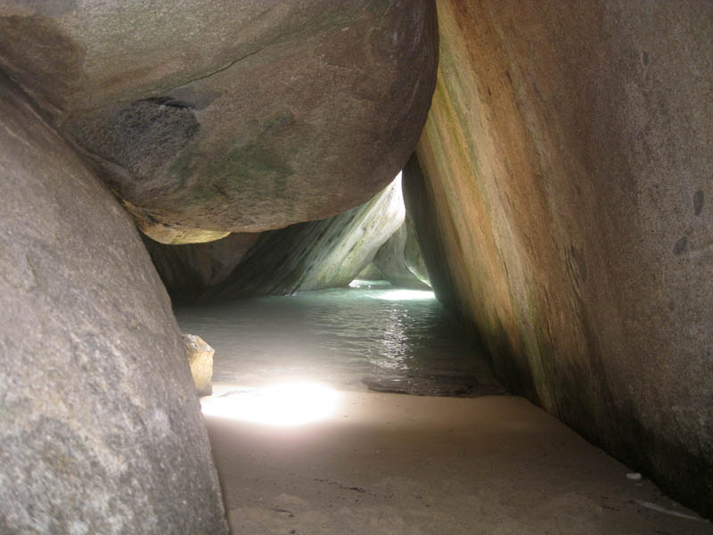
The boulders here are the exhumed innards of a granite pluton that crystallised kilometres underground about 45 million years ago.

VirginGordaTheBaths.jpg · <a href="//commons.wikimedia.org/wiki/User:Calyponte" title="User:Calyponte">Calyponte</a> · CC BY 3.0
Spring tide
0.20 m
Nearest airport
VIJ · 3 km
Tier
Featured
I’m here for
Story

The Baths sit at the southern tip of Virgin Gorda in the British Virgin Islands, about 1.9 kilometres south of Spanish Town, between Spring Bay and Devil's Bay. The thing that makes the place is the rock: granite boulders, the largest about 40 feet (12 metres) across, piled along the shore into a maze of tidal pools, tunnels, arches, and grottoes that are open to the sea. Most of the BVI is built of volcanic rock. Virgin Gorda's south end is granite, and the contrast is the whole story.

That granite is part of the Virgin Islands Batholith, a body of plutonic rock that crystallised from magma kilometres below the surface during the Eocene, roughly 45 million years ago. It never erupted. It cooled slowly at depth, cracked into rough blocks as it cooled and as the weight above it was stripped away, and then waited while tens of millions of years of erosion removed everything that had once covered it. What you walk through at The Baths is the exhumed core of that pluton, its blocks rounded by weathering into the boulders you see now.

The visit is physical. From the car park above, a marked trail drops to the main beach, then threads through the boulders along a route called the Caves: you bend under overhangs, climb fixed wooden ladders and ropes, wade through sea pools, and step across wet, slippery rock to come out the far side at Devil's Bay, a horseshoe of sand you cannot see from the path. The whole scramble runs perhaps fifteen to twenty minutes if you are not waiting on anyone. Swimming and snorkelling in the sheltered water between the boulders are the other two reasons people come.

The Baths has been a BVI National Park since 1990, managed within the protected-areas network overseen by the National Parks Trust of the Virgin Islands. Adjacent Devil's Bay was designated earlier, in 1964. The park is small, unfenced at the water, and free to enter, which is part of why it fills the way it does.

It also sits in a hurricane corridor. On 6 September 2017 the eye of Hurricane Irma, a Category 5 storm with sustained winds near 185 mph, passed directly over Virgin Gorda, Tortola, and Jost Van Dyke. The granite did not care. The islands around it did: four people died in the BVI, and roughly 85 percent of the territory's housing was damaged or destroyed. The boulders outlasted the storm; the human infrastructure around them had to be rebuilt.

The spike

The boulders here are the exhumed innards of a granite pluton that crystallised kilometres underground about 45 million years ago.

The Baths is a beach you can only have because a mountain's worth of rock was removed from above it. The boulders are not driftwood of the sea or anything the waves built. They are the deep interior of a granite pluton, brought to the surface by erosion and left lying on the shore. To understand the place you have to think in two directions at once: down, into where the rock formed, and up, through everything that has since been carried away.

Start with the magma. Around 45 million years ago, in the Eocene, molten rock pushed up into the older volcanic crust of the young Caribbean plate and stalled several kilometres below the surface. It did not break through to erupt. Trapped at depth, under the pressure and insulation of the rock above it, it cooled slowly. Slow cooling is why this is granite and not lava: the minerals had time to grow into interlocking crystals you can see with the naked eye. The Virgin Islands Batholith, of which The Baths is one piece, is a large plutonic body that ranges in composition from gabbro to granodiorite. Zircon dating of the batholith places its emplacement in the Eocene, beginning around 43.5 million years ago and continuing for more than ten million years across several separate plutons. This is some of the youngest plutonic rock in the Greater Antilles. The popular literature about The Baths often calls the rock simply granite and quotes an age of about 50 million years; that is close, and granodiorite is a granitic rock, so neither framing is wrong, but the precise number comes from the geochronology, not the brochures.

Note what is not true here. A common claim is that this granite is Cretaceous. The peer-reviewed dating does not support that for the Virgin Islands Batholith, which is Eocene. Another tempting story is that the boulders are volcanic. They are the opposite: this is intrusive rock that never reached the surface as lava, the deep counterpart to the volcanic rock that makes up the rest of the islands.

Now the cracking. As a granite pluton cools and as the kilometres of rock above it are slowly eroded off, the pressure on it drops. Granite responds to that unloading by fracturing. It develops joints, sets of roughly planar cracks, often in three directions that intersect to cut the solid mass into rough rectangular blocks. The Baths granite did exactly this. Before any of it saw daylight, the rock was already divided underground into a stack of blocks separated by joints. That jointing is the template for every boulder on the beach. The blocks were the bricks; weathering only rounded their corners.

Then the unburial. Erosion is the slow engine. Over tens of millions of years, rain, runoff, and the sea stripped away the volcanic and sedimentary cover that once lay over the pluton. Water worked down into the joints. In the tropics, rainwater is faintly acidic and chemically attacks feldspar in the granite, rotting it into clay along the crack faces while leaving the harder quartz behind as loose grains. Corners and edges, exposed on more sides, weather fastest, so the sharp-cornered blocks slowly become rounded. This is spheroidal weathering, and it is why the boulders look poured rather than quarried. The slippery white film many visitors notice on the rock is the residue of that decay, quartz grains left behind after the feldspar has gone. The boulders did not roll here and grind smooth. They are sitting at or near where they crystallised, rounded in place as the rock around their joints rotted away and washed off.

The beach is the by-product. The sand between and beneath the boulders is the same granite taken to its end state, feldspar-rich grit and quartz weathered out of the rock and washed down. The tidal pools, tunnels, and grottoes are simply the gaps the joints left, now flooded by the sea. A grotto at The Baths is a room with a granite-block roof, lit through cracks above, with seawater on the floor. Cathedral comparisons get made constantly, and the architecture is genuinely the same idea: a roof of stone held up by stone, with light coming through the gaps. The difference is that no one designed it. Joint geometry and 45 million years of weathering did.

Why this is singular, not just pretty. Granite shorelines exist elsewhere; Seychelles' Anse Source d'Argent and South Africa's Boulders Beach are the obvious cousins. What sets The Baths apart is the completeness of the exhumed-pluton story in a space small enough to walk through in twenty minutes, in a place where the surrounding islands are volcanic so the granite reads as an anomaly the moment you arrive. You are not looking at a granite outcrop. You are standing inside the cooled, cracked, and unburied guts of a mountain that erosion has spent the Cenozoic taking apart over your head. The roof is gone. The interior is the beach.

And it is provisional in human terms only. On a geological clock the boulders will sit here for ages yet. On a human one, the soft things around them, the trees on the headland, the ladders bolted into the rock, the buildings up the hill, are repeatedly rearranged by storms. Hurricane Irma in 2017 is the most recent proof. The rock is the permanent thing at The Baths. Everything else, including the way you are allowed to move through it, is temporary.

Virgin Gorda Boulders2.jpg
Culture

Where it shows up

Brand & advertising
  • BVI tourism icon

    The Baths' boulder grottoes are one of the British Virgin Islands' most recognised images and a fixture of the territory's tourism marketing, standing in for the BVI the way Table Mountain stands in for Cape Town.

Other
  • Cruise shore excursion staple

    Major cruise lines sell The Baths as a flagship Virgin Gorda shore excursion from Tortola, which is the principal driver of the midday crowding through the Caves trail.

  • Painkiller cocktail

    The Painkiller, a rum, pineapple, orange, coconut-cream and nutmeg cocktail, originated in the BVI at the Soggy Dollar Bar on Jost Van Dyke and is the territory's most exported drink, frequently served to visitors on Baths day trips.

History
  • The name 'The Baths'

    The site is named for the bath-like seawater pools the boulders enclose; the calm, sheltered, room-sized pools between the rocks read as natural baths, and the name long predates the area's national-park status.

TheBaths VirginGorda BVI.jpg
History

What happened here

  1. -45000000natural

    Granite crystallises underground

    Magma intrudes the volcanic crust of the young Caribbean plate and cools slowly several kilometres down, forming the granitic rock of the Virgin Islands Batholith. Zircon dating places the batholith's emplacement in the Eocene, beginning around 43.5 million years ago.

    Wikipedia →
  2. 1964conservation

    Devil's Bay designated a national park

    Devil's Bay, the horseshoe beach reached by scrambling through the boulders from The Baths, was designated a national park in 1964, predating the protection of The Baths itself.

  3. 1990conservation

    The Baths becomes a BVI National Park

    The Baths was designated a BVI National Park in 1990, along with adjacent bays, bringing the boulder shoreline under the protected-areas network managed by the National Parks Trust of the Virgin Islands.

    Wikipedia →
  4. 2010natural

    Establishes as a global icon of Caribbean geology

    By the 2010s The Baths had become one of the BVI's two or three most photographed sites and a fixture of cruise shore-excursion itineraries, with the boulder grottoes standing in for the territory in tourism marketing.

    Wikipedia →
  5. 2017disaster

    Hurricane Irma's eye crosses Virgin Gorda

    On 6 September 2017 the eye of Hurricane Irma, a Category 5 storm with sustained winds near 185 mph, passed directly over Virgin Gorda, Tortola, and Jost Van Dyke. Four people died in the BVI and roughly 85 percent of the territory's housing was damaged or destroyed.

    Wikipedia →
  6. 2017humanitarian

    Operation Ruman relief response

    In Irma's immediate aftermath the United Kingdom launched Operation Ruman, deploying military and aid resources to the BVI and other British Caribbean territories to support search, security, and the start of recovery.

    Wikipedia →
  7. 2019development

    Tourism recovery on Virgin Gorda

    By 2019 Virgin Gorda's tourism and infrastructure had substantially recovered from Irma, with The Baths back in operation as a leading day-trip and cruise excursion destination after the rebuilding of access and facilities.

The honest part
The granite shrugged off a Category 5 hurricane that killed four people and flattened most of the islands around it; the rock is the only thing here that storms cannot rearrange.

The Baths is small, free, and famous, which is a hard combination. The trail through the boulders is narrow with real choke points, the snorkel slots and photo spots only fit a few people at a time, and the wooden ladders force single-file movement. When cruise ships are in port, day-trippers arrive in waves from Tortola and the US and British Virgin Islands, and the Caves trail backs up into a queue; visitors report waiting in line, inside the rock, to inch through passages built for one person. Reviews regularly describe the place as either a wonder or a crush depending entirely on whether you beat the boats. The park has no entrance fee and no cap, so the crowd is self-regulated only by the size of the car park and the patience of the people in it.

The second uncomfortable truth is exposure. This is a hurricane coast. Ninety tropical-cyclone tracks have passed within range of it in the historical record, and on 6 September 2017 Hurricane Irma's Category 5 eye crossed Virgin Gorda directly, killing four people across the BVI and damaging or destroying roughly 85 percent of the territory's homes. The boulders shrugged it off; they are tens of millions of years old. The people who live and work around them did not, and the recovery of the BVI's tourism and housing took years. Visiting The Baths means visiting an indestructible landscape attached to a fragile community that periodically has to rebuild around it.

TheBaths RockFormation BritishVirginIslands Feb6-2000.jpg
Anatomy

The shape of the place

Spring Bay

10%

A separate boulder-strewn beach just north of The Baths with similar granite formations and calmer, shallower water, far less visited than the main site.

Best for The Baths-style boulders and snorkelling without the cruise crowds

Often overlooked because it lacks the famous Caves trail; a good fallback when The Baths is full.

The Baths main beach

40%

The sandy arrival beach at the foot of the trail from the car park, framed by the largest boulders. Restrooms are on site. This is where the swimming and the boulder scramble both begin.

Best for First arrival, swimming, photographs of the big boulders

Gets busiest when boat passengers land; the sand is the same weathered granite as the rock above it.

The Caves trail

60%

The marked route through the boulders, with fixed wooden ladders, ropes, overhangs, and flooded tidal pools, linking The Baths to Devil's Bay. The grottoes are open to the sea and lit through gaps in the block roof.

Best for The scramble itself; the signature grotto photographs

Single-file choke points; this is where queues form on cruise days. Wet, slippery rock throughout.

Devil's Bay

85%

A horseshoe of sand at the far end of the Caves trail, invisible from the main beach, with clear sheltered water. A national park in its own right since 1964.

Best for A calmer swim away from the arrival crowd; the payoff at the end of the scramble

Reachable only by the boulder trail from The Baths or by boat; no direct road access.

Landmarks

The Baths boulders

geological_formation

Granite boulders up to about 40 feet (12 m) across, the exhumed and weathered blocks of an Eocene pluton in the Virgin Islands Batholith, forming the tidal pools, tunnels, arches, and grottoes that define the beach.

Wikipedia →

The Caves grottoes

natural_feature

Sea-flooded chambers between the boulders, roofed by granite blocks and lit through gaps above, threaded by a ladder-and-rope trail from The Baths to Devil's Bay. The most photographed feature in the park.

Wikipedia →

Devil's Bay National Park · 1964

national_park · National Parks Trust of the Virgin Islands

The horseshoe beach reached through the boulders from The Baths, designated a national park in 1964 and managed within the BVI's protected-areas network.

Wikipedia →
A day here

From first light to dark

Dawn

The gate at The Baths typically opens around 8-9am, and the first hour is the prize: the Caves trail is empty, the low sun rakes across the granite, and the tidal pools sit glassy before any swell or any crowd. This is the only window when you can move through the boulders at your own pace.

Midday

By late morning the cruise and day-trip boats have landed their passengers and the narrow passages back up into a queue; people wait single-file inside the rock to pass the choke points. Overhead noon light flattens the boulders and throws hard short shadows, and the swimming coves between the rocks are busiest.

Golden hour

Late afternoon the boats pull out and the trail empties again. Warm light catches the grain of the granite, the small spring tidal range, barely 20 centimetres here, means the pools change little, and the sheltered water on the lee side of the boulders stays calm for a last swim.

Night

The park closes at dusk and there is no lighting in the boulders; the Caves trail is genuinely dangerous in the dark over wet rock. Land crabs and hermit crabs move on the sand after sunset, and the grottoes fall silent except for water working through the gaps.

Compare

How it ranks

Peak warmth
Warmer than 81% of beaches in its country
Peak-month high ≈ 31°C
Worldwide
Among the warmest 13% of beaches on Earth

Ranked against every beach in our database — 228,000+ worldwide.

CaveAtTheBaths01.JPG
Sea & surf

What the water does

JFMAMJJASONDmetres (significant wave height)

Solid = typical monthly wave height; pale = the bigger days (90th pct). Offshore/regional swell from Open-Meteo Marine (ERA5 Ocean reanalysis, 2023–2024); a sheltered cove may sit calmer than this.

Mixed — usually swimmable, with a livelier season
Typical wave height
1.16 m
Biggest swell
Jan · 1.3 m
Calmest
May · 0.97 m
Typical period
6.3 s (wind chop)
Before you go

Things to know

Beat the boats

Arrive when the gate opens, before the cruise and day-trip passengers land mid-morning. The Caves trail is a calm wonder early and a single-file queue by late morning.

It is a scramble, not a stroll

The trail to Devil's Bay uses fixed wooden ladders, ropes, overhangs, and flooded pools over wet granite. Wear water shoes, carry a dry bag, and keep both hands free.

No fee, no food, no cap

Entry is free and there is no visitor limit, so crowding is real. There is no food service in the boulders; bring water, since the heat and the scramble are dehydrating.

Check the swell and the season

The pools are usually calm and swimmable, but Atlantic swells can make entry between the boulders difficult, and the June-November hurricane season can bring rough seas. Conditions vary day to day.

Sharks

No incidents on record in the global shark-attack file.

Plan

If you go

Getting there
Nearest airport
Virgin Gorda Airport (VIJ) · 3 km
Nearest town
Tortola · 17 km

The Baths is at the southern tip of Virgin Gorda, about 1.9 km south of Spanish Town. Most visitors reach Virgin Gorda by ferry from Tortola (roughly 30 minutes Road Town to Spanish Town), then drive or taxi about 10-15 minutes to the car park above the beach, where a marked trail descends to the sand. Virgin Gorda Airport (VIJ) is only 2.7 km away but has limited service; many arrivals instead fly into Tortola (EIS) or San Juan and continue by ferry. Day-trip and cruise excursion boats also land passengers directly.

When to go
  • Cruise-ship arrival waves · Most weekdays in the December-April high season

    On days when cruise ships are in port at Tortola, day-trip passengers arrive in concentrated waves from mid-morning, and the narrow Caves trail backs up into a queue. The pattern is the single biggest determinant of how the visit feels.

  • Atlantic hurricane season · 1 June to 30 November

    The BVI lies in the hurricane belt; the official season runs June through November, peaking around September. Direct hits are rare but consequential, as Hurricane Irma showed in September 2017, and rough seas can close the boulder pools to swimming.

What to eat & drink
Fish and fungi

The BVI's traditional plate: stewed or fried local fish served with fungi, a cornmeal-and-okra polenta. It is the territory's most cited national dish and a fixture of older West Indian kitchens across the islands.

Local restaurants in Spanish Town, Virgin Gorda, not on the beach itself.

Roti

A West Indian flatbread wrapped around curried chicken, conch, or vegetables, brought to the Caribbean by Indo-Caribbean communities and now standard island lunch food.

Casual spots in Spanish Town; bring it as a packed lunch, since there is no real food service in the boulders.

Conch in various forms

Queen conch, eaten as fritters, in a creole stew, or as a marinated salad. A traditional BVI ingredient now subject to fishery regulation across the region because of overharvesting.

Restaurants in Spanish Town and Virgin Gorda yacht-harbour eateries.

Painkiller

The BVI's claimed signature cocktail: dark rum, pineapple and orange juice, cream of coconut, and grated nutmeg, popularised at the Soggy Dollar Bar on Jost Van Dyke. It originates in the territory, not at The Baths.

Bars on Virgin Gorda and across the BVI; there is no bar inside the park.

Sources & references
  1. Wikipedia: The Baths · cited 3×
  2. Wikipedia: Effects of Hurricane Irma in the BVI · cited 2×
  3. Smith et al., Geochemistry and Geochronology of the Virgin Islands Batholith
  4. bvitourism.com national parks
  5. Wikipedia: The Baths; cruise-line excursion listings
  6. Wikipedia: Operation RUMAN
  7. Virgin Islands Property & Yacht (2019 Virgin Gorda special edition)
  8. Smith et al., Geochemistry and Geochronology of the Virgin Islands Batholith (zircon ID-TIMS)
  9. Wikipedia: The Baths; bvitourism.com national parks
  10. AllTrails; cruise and visitor guides
  11. IBTrACS v04r01 (NOAA)
  12. Open-Meteo Marine (ERA5, 2023-2024)
Colophon · Provenance

Where this page comes from

Geography, facilities
OpenStreetMap (ODbL) for geometry and facility tags within 500 m of the beach centroid. GeoNames for city/airport distances.
Climate & ocean
worldclim_v2.1_2.5m
Tides
eot20
Photography
Archival, original tone (Tier B — Wikimedia Commons). Each image licensed per its own terms; attribution visible inline.
History & culture
Every factual claim is linked to its source in the prose above. Wikipedia citations inline. Non-wiki sources named where relevant.
Editorial voice
Register: reverent. Written to pass a local's nod test; corrections welcome.
Written by Erin Rose
Last reviewed 2026-04-19
v0.9in editorial development toward v1.0