Otago, NZ

Tunnel Beach

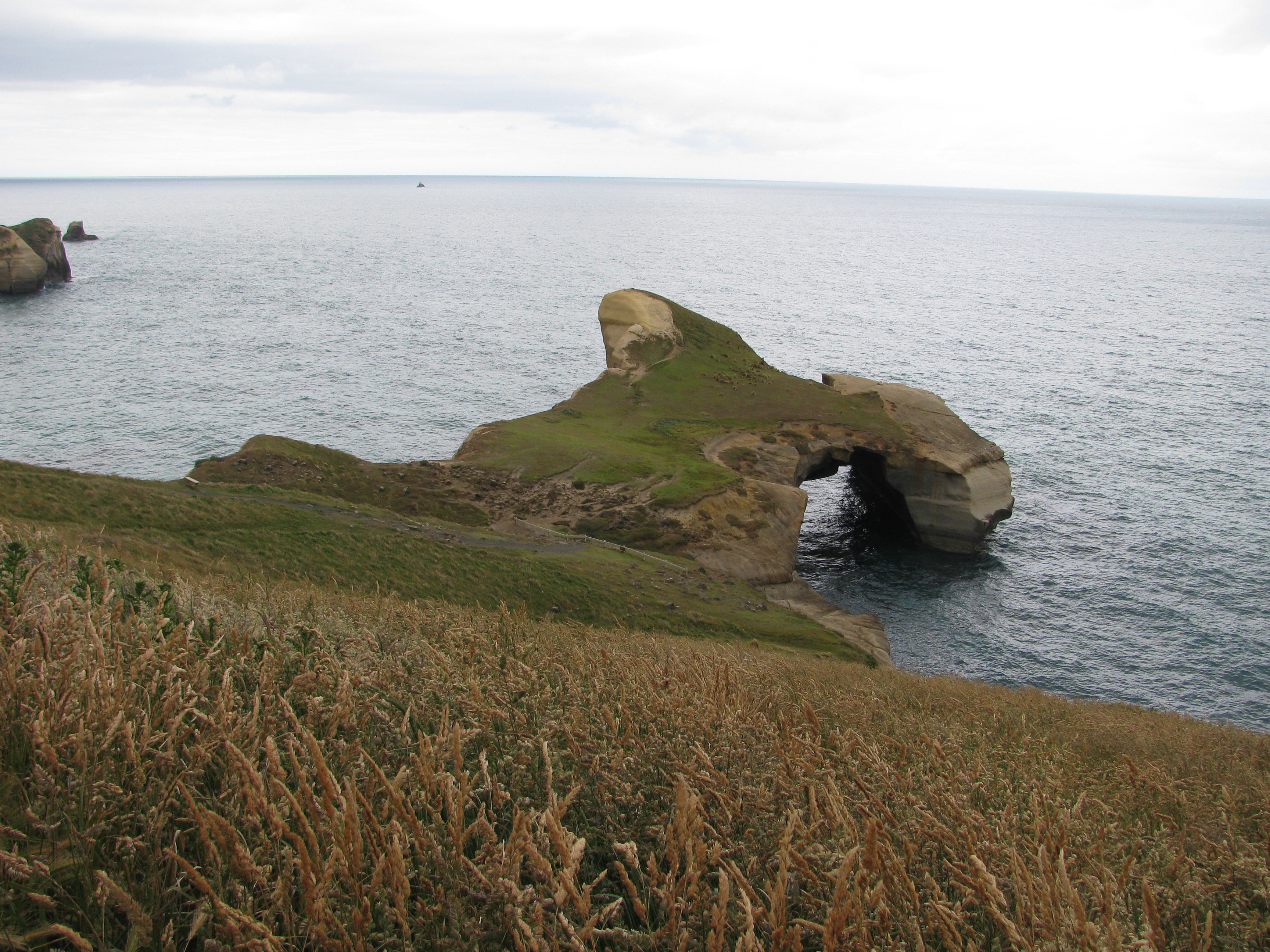
Cliffs around Tunnel Beach.jpg

Otago, NZ

Tunnel Beach

Politician John Cargill commissioned this tunnel in the 1870s for private beach access; the drowned-daughters legend attached to it is fiction.

Cliffs around Tunnel Beach.jpg · <a href="https://en.wikipedia.org/wiki/User:Pseudopanax" class="extiw" title="wikipedia:User:Pseudopanax">Pseudopanax</a> at <a href="https://en.wikipedia.org/wiki/" class="extiw" title="wikipedia:">E · Public domain
Nearest airport
DUD · 20 km
I’m here for
Story

Tunnel Beach is a small sandstone cove 7.5 kilometers southwest of central Dunedin, New Zealand, reached only through a hand-carved tunnel cut through sandstone cliffs. Those cliffs are Caversham Sandstone, an Early-to-Middle Miocene marine deposit roughly 15 to 20 million years old, holding marine fossils (brachiopods, echinoderms) visible in the rock face. The tunnel is 72 steps of hand-tool-marked stone, dim and low-ceilinged, opening onto a cove framed by a natural sea arch and sea stacks.

John Cargill cut the tunnel in the 1870s. He was a Dunedin-area politician, MP for Dunedin Country from 1853 to 1858 and for Bruce from 1866 to 1870, who had made his money running roughly 55,000 merino sheep, together with his son-in-law, on the Teviot run in South Otago. He wanted private access to the beach from land his family held above the cliffs, at a time when this stretch of coast was still large private runs, not public reserve. Cargill later left New Zealand; he died on 2 January 1898 at Okanagan, British Columbia, on the far side of the Pacific from the staircase he cut.

Local legend holds that Cargill built the tunnel to give his daughters private access to the beach, and that one of them later drowned there. Wikipedia's Tunnel Beach article states there is no truth to the story. What actually happened is duller and more revealing: a wealthy landowner wanted quicker access to his own beach, so he had it dug. The real danger here isn't a drowned daughter of folklore but dangerous currents and waves that DOC advises against swimming in, and a genuinely steep, wet track.

The tunnel opened to the public in 1983, when concrete steps were added to what had been a bare slope; DOC manages the reserve today. The walk from the car park now runs 2.6 kilometers return, descending roughly 150 meters from the trailhead to sea level per Wikipedia, past five lookout points, or "nests," to the tunnel and beach. In October 2024 a single storm triggered at least ten large slips along the 1.3-kilometer track, closing it outright; repairs kept it shut for thirteen months, and DOC reopened it on 14 November 2025, timed for summer.

Fur seals and sea lions haul out on the rocks below; DOC asks a 20-meter distance. The cove itself is small, tidal, and exposed to Southern Ocean swell, with no lifeguard and no cell signal. Nothing is sold at Tunnel Beach — no kiosk, no vendor, not even a bin — since it is unstaffed DOC land behind a gated car park whose hours shrink in winter.

The spike

Politician John Cargill commissioned this tunnel in the 1870s for private beach access; the drowned-daughters legend attached to it is fiction.

Tunnel Beach is a story about who gets to reach the water, told through a hole cut in a cliff. In the 1870s a wealthy pastoralist named John Cargill commissioned a tunnel cut through Miocene sandstone cliffs so his family could walk down to a private cove without going around by boat or track. That is the entire, undramatic origin of one of Dunedin's best-known short walks. It survives today because the man who built it had the money to move rock for convenience, and because more than a century later the Department of Conservation decided the public should have what only the Cargills once did.

The man who dug it. John Cargill was not a random landowner. He sat in Parliament for Dunedin Country from 1853 to 1858 and for the Bruce electorate from 1866 to 1870, and his fortune came from sheep: he and his son-in-law ran roughly 55,000 merino on the Teviot run in South Otago, one of the large pastoral holdings that defined the colonial Otago economy. His family held land above the cliffs south of the young Scottish settlement of Dunedin, at a time when that coastline was still private runs rather than public reserve. Cutting a tunnel through sandstone for a family beach outing was, for a man with that kind of income, a reasonable expense. He eventually left New Zealand; he died on 2 January 1898 at Okanagan, British Columbia, a long way from the staircase he had ordered dug into a New Zealand cliff face.

The legend that grew around it. A local legend attached itself to the tunnel: that Cargill built it to give his daughters private access to the beach, and that one of them (some tellings say two) later drowned there. It is a tidy narrative, the kind of origin story that makes a strange piece of infrastructure feel meaningful. It is also, according to Wikipedia's Tunnel Beach article, false: there is no truth to the drowning story. What the documentary record actually shows is a rich man building himself convenient stairs, with no drowning attached to any daughter's name.

Why the fabrication matters more than the fact. A tunnel built for a drowned daughter and a tunnel built for a landowner's convenience are the same object, but they carry different weight. The legend converts an act of private wealth and control over land access into an act of grief, which is more sympathetic and more marketable. It is easy to see why the story stuck: "rich man builds shortcut to his beach" doesn't sell tickets to a walking track. "Devoted father carves his daughters a private stairway to the sea, and one drowns using it" does. The debunking on Wikipedia is one paragraph, unsourced beyond the site's own citation apparatus, but the shape of the correction is itself instructive: tourism narratives default to sentiment over economic history, even when the economic history is the more interesting story.

The actual danger is not folklore. While the drowned-daughter story is invented, Tunnel Beach is genuinely dangerous in ways that have nothing to do with legend. The Department of Conservation warns of dangerous currents and waves there, calls the cove unsafe at high tide and in rough seas, and notes it is not patrolled by lifeguards. The beach is small, tidal, and unmonitored, with no cell reception in the cove. The 2.6-kilometer return track is steep enough that DOC itself calls the section past the first lookout "strenuous." In October 2024, a single severe-weather event triggered at least ten large slips along the 1.3-kilometer track, closing the entire site for repairs and geotechnical assessment; it did not reopen until 14 November 2025, more than a year later. None of this required an invented drowning. The cliffs, the currents, and the weather are dangerous enough on their own, on the record, with dates attached.

What the tunnel actually demonstrates. Strip away the legend and what's left is a clean case study in how private infrastructure becomes public heritage. A 19th-century landowner used his wealth to solve a personal access problem by altering the coastline. A century later, concrete steps were added in 1983 when the site opened to the public; the state eventually took over the altered coastline, built a formal track with five named lookout points, and now manages the closures, the geotechnical risk, and the rescues that come with letting the public use what was once one family's private staircase. The sea arch and the fossil-bearing sandstone would exist with or without Cargill's tunnel. What makes Tunnel Beach specifically what it is — a destination rather than an inaccessible cliff line — is a decision made by one man with sheep money in the 1870s, later inherited by a government agency that still has to manage the consequences of where he chose to cut.

Tunnel Beach (3).jpg
Culture

Where it shows up

History
  • The drowned-daughters legend

    A local story claiming Cargill built the tunnel to give his daughters private access to the beach and that one later drowned there; Wikipedia's Tunnel Beach article finds no truth to the drowning.

  • The founding of the Otago settlement · 1848
    William Cargill

    John Cargill's father, William Cargill, led the Otago Association's settlement of Dunedin, arriving at Port Chalmers on the John Wickliffe on 23 March 1848 and later serving as the province's first Superintendent; the family's pastoral wealth in the following decades funded the private tunnel.

Other
  • "One of Dunedin's best short walks"
    Department of Conservation

    DOC's own official description of the Tunnel Beach Walk, framing it as a short, high-value track rather than a themed or legend-driven attraction.

Tunnel Beach New Zealand I.jpg
History

What happened here

  1. 1821historic

    John Cargill is born

    John Cargill, later the tunnel's builder, is born in England, the son of Captain William Cargill.

    Wikipedia →
  2. 1848founding

    William Cargill founds the Otago settlement

    John Cargill's father, William Cargill, arrives at Port Chalmers aboard the John Wickliffe on 23 March 1848 and becomes the founding figure of the Otago settlement; the family's later wealth and land in the area trace to this founding.

    Wikipedia →
  3. 1853policy

    John Cargill enters Parliament

    John Cargill is elected MP for Dunedin Country, serving until 1858, alongside his father's own parliamentary and provincial roles.

    Wikipedia →
  4. 1866policy

    John Cargill becomes MP for Bruce

    John Cargill returns to Parliament as MP for the Bruce electorate, serving until 1870, around the same period the Teviot run and the Tunnel Beach tunnel are established.

    Wikipedia →
  5. 1870founding

    The tunnel is hand-carved (circa)

    John Cargill has a tunnel hand-cut through the Caversham Sandstone cliffs for private family access to the beach below; sources date this only to the 1870s, not a specific year.

    Wikipedia →
  6. 1898historic

    John Cargill dies in British Columbia

    John Cargill dies on 2 January 1898 at Okanagan, British Columbia, Canada, far from the tunnel and land he had held in Otago.

    Wikipedia →
  7. 1983policy

    Tunnel Beach opens to the public

    The tunnel and track open to the public, with concrete steps added to what had been a bare, carved slope; DOC manages the reserve today.

    Wikipedia →
  8. 2024natural

    A storm closes the track

    A severe weather event triggers at least ten large slips along the 1.3 km Tunnel Beach track, forcing a full closure for safety assessment and repair.

  9. 2025policy

    The track reopens

    The Department of Conservation reopens Tunnel Beach Track on Friday 14 November 2025, thirteen months after the October 2024 closure, timed for the New Zealand summer.

The honest part
“The tunnel exists because one family could afford to cut through rock, and most families around them could not.”

The honest problem with Tunnel Beach's most-told story is that it isn't true, and the true story is more useful. There's no record that any of John Cargill's daughters drowned there; the beach's own reference material says so directly. What actually built the tunnel was ordinary 19th-century wealth: a politician who ran roughly 55,000 sheep with his son-in-law, converting some of that money into a private staircase through his own cliff, at a time when this coastline belonged to a handful of large landholders rather than the public. The romantic version erases that arrangement and replaces it with grief, which is a more comfortable thing to think about while walking a hand-carved tunnel than the fact that it exists because one family could afford to cut through rock and most families around them could not.

The site's real risks are undramatic and well documented rather than folkloric. DOC warns of dangerous currents and waves and calls the cove unsafe at high tide and in rough seas, and people have been hurt falling on the steep track. In October 2024, a single storm put at least ten large slips across the 1.3-kilometer route and shut it for thirteen months, a closure length that reflects how unstable this stretch of Caversham Sandstone can be under heavy rain, not a one-off event. The track that reopened in November 2025 sits on the same geology that failed in 2024; nothing about the reopening changes the fact that another severe-weather event could close it again.

Tunnel Beach New Zealand II.jpg
Anatomy

The shape of the place

Tunnel Beach car park

0%

The gated Department of Conservation car park at the end of Tunnel Beach Road, the only vehicle access point to the track.

Gates lock at posted hours (8am-9pm Sep-Mar, 9am-5pm Apr-Aug); vehicles left inside after closing risk being impounded.

The clifftop lookouts

20%

Five named lookout points ('nests') along the clifftop track between the car park and the tunnel, overlooking the sandstone cliffs and coastline.

Best for Clifftop views without descending the tunnel

The track beyond the first lookout is steep; DOC describes it as strenuous.

The tunnel and steps

50%

72 hand-carved steps through Caversham Sandstone, low-ceilinged and dimly lit by daylight from either end; the only way down to the cove.

Best for The approach itself, and photographing the carved rock and light shaft

Cut in the 1870s by John Cargill; concrete steps added in 1983.

The cove and sea arch

55%

A small, tidal cove of sand and rock framed by a natural sea arch and sea stacks, exposed to Southern Ocean swell.

Best for Viewing the sea arch and cliffs at low tide

DOC advises against swimming because of dangerous currents and waves; the cove is not patrolled by lifeguards.

Landmarks

The Tunnel Beach tunnel

structure · John Cargill (commissioned)

A hand-carved passage of 72 steps through Caversham Sandstone, cut in the 1870s for private family access; concrete steps were added when it opened to the public in 1983, and DOC manages the reserve today.

Wikipedia →

Tunnel Beach sea arch

natural_feature

A natural sandstone sea arch framing the cove, formed by marine erosion of the Caversham Sandstone cliffs over the Quaternary.

Wikipedia →

St Clair Beach

beach

The nearest sizeable beach and suburb, roughly 2.3 km northeast of Tunnel Beach as the crow flies; it hosts Dunedin's surf lifesaving club and the region's main surf-competition venue, unlike the unstaffed Tunnel Beach.

A day here

From first light to dark

Dawn

The car park gate doesn't open until 8am in summer or 9am in winter, so nobody legally reaches the tunnel at first light; the earliest visitors get is low morning sun raking the clifftop lookouts before the steep final descent.

Midday

By midday the sandstone cliffs are lit flat and the small cove is at its most exposed or most submerged depending on the tide; the beach is tidal and DOC posts no tide table on site, so checking one before descending matters more than the light.

Golden hour

Late afternoon sends direct light down the tunnel shaft and across the sea arch. In summer the 9pm gate closing leaves time for a full sunset; in winter the 5pm closing cuts visitors off well before golden hour reaches the water.

Night

After the gate locks — 5pm in winter, 9pm in summer — the car park closes and vehicles left inside risk being impounded. Nobody stays at Tunnel Beach after hours; the cove has no lighting, no cell signal, and no lifeguard at any hour.

Before you go

Things to know

Not for swimming

DOC warns of dangerous currents and waves at Tunnel Beach and calls the cove unsafe at high tide and in rough seas; there is no lifeguard and no cell reception in the cove.

Gated, timed access

The car park gate locks outside posted hours (8am-9pm Sep-Mar, 9am-5pm Apr-Aug); vehicles left inside after closing risk being impounded.

Reopened November 2025

The track was fully closed from October 2024 to 14 November 2025 after a storm caused at least ten large slips; check current DOC alerts before visiting, since this stretch of cliff is prone to slips after heavy rain.

Steep, slippery, no handrail

The 2.6 km return track and the unlit, low-ceilinged tunnel are steep and become slippery when wet; DOC calls the section past the first lookout strenuous, and the site has high, unfenced cliffs with steep drops and unstable edges.

Car park break-ins

DOC warns that thieves may target cars parked at the Tunnel Beach car park; take valuables with you.

Sharks

No incidents on record in the global shark-attack file.

Plan

If you go

Getting there
Nearest airport
Dunedin International Airport (DUD) · 20 km
Nearest town
Dunedin · 6 km

Tunnel Beach is reached by car via Blackhead Road and Tunnel Beach Road, about 7.5 km southwest of central Dunedin (roughly 15-20 minutes' drive); there is no public transport to the car park itself. The dataset's straight-line distance from the beach to Dunedin International Airport (DUD) is 20.3 km, but that is not a road figure — Dunedin Airport's own site states the airport is 27 km south of the city and to allow 30 minutes to drive between the city and the airport. Tunnel Beach is a further 7.5 km southwest of central Dunedin, on the same side of the city as the airport, so the airport-to-beach road route (via SH1 through Mosgiel, or via Brighton) runs roughly 30-35 km and 30-40 minutes — confirm with a route planner. From the car park, the track itself is 2.6 km return, through the tunnel, to the beach.

When to go
  • None at Tunnel Beach itself · N/A

    Tunnel Beach hosts no organized recurring events; it is unstaffed DOC land with a gated car park. The nearest recurring beach event is the Midwinter Plunge charity swim at St Clair Beach, roughly 2.3 km away, held annually at the June winter solstice.

What to eat & drink
Nothing at Tunnel Beach itself

Tunnel Beach is unstaffed Department of Conservation land: no kiosk, no vendor, no rubbish bin. Visitors are expected to bring their own water and carry out what they carry in.

Tunnel Beach car park and track

Fish and chips

The standard South Island seaside meal, sold at takeaway shops rather than at any beach; the nearest are in St Clair and central Dunedin.

Takeaway shops in St Clair (roughly 2.3 km northeast) and central Dunedin (7.5 km northeast by road)

Cheese rolls

A toasted, savory bread-and-cheese roll specific to Otago and Southland, sold at cafes and bakeries rather than as a beach food.

Cafes and bakeries across Dunedin

Bluff oysters, in season

The regional delicacy from Foveaux Strait, further south, but served in Dunedin restaurants during the season, typically March to August.

Seafood restaurants in central Dunedin

Sources & references
  1. Wikipedia: John Cargill (politician) · cited 5×
  2. Wikipedia: Tunnel Beach · cited 4×
  3. Department of Conservation: Tunnel Beach Walk · cited 2×
  4. Wikipedia: William Cargill (New Zealand politician)
  5. Wikipedia: Tunnel Beach; Department of Conservation
  6. Department of Conservation; Otago Daily Times; Stuff.co.nz
  7. Department of Conservation media release; Otago Daily Times
  8. Wikipedia: Tunnel Beach; Otakou Group geological description
  9. Department of Conservation media release; Otago Daily Times; Stuff.co.nz
Colophon · Provenance

Where this page comes from

Geography, facilities
OpenStreetMap (ODbL) for geometry and facility tags within 500 m of the beach centroid. GeoNames for city/airport distances.
Climate & ocean
Open-Meteo ERA5 + Marine archive, 2014–2023 monthly normals.
Photography
Archival, original tone (Tier B — Wikimedia Commons). Each image licensed per its own terms; attribution visible inline.
History & culture
Every factual claim is linked to its source in the prose above. Wikipedia citations inline. Non-wiki sources named where relevant.
Editorial voice
Register: wry. Written to pass a local's nod test; corrections welcome.
Written by Erin Rose
Last reviewed 2026-04-19
v0.9 — in editorial development toward v1.0